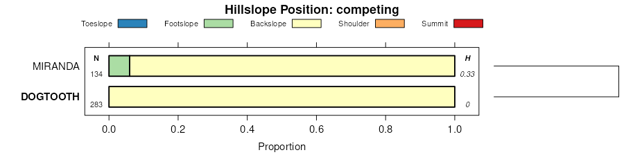
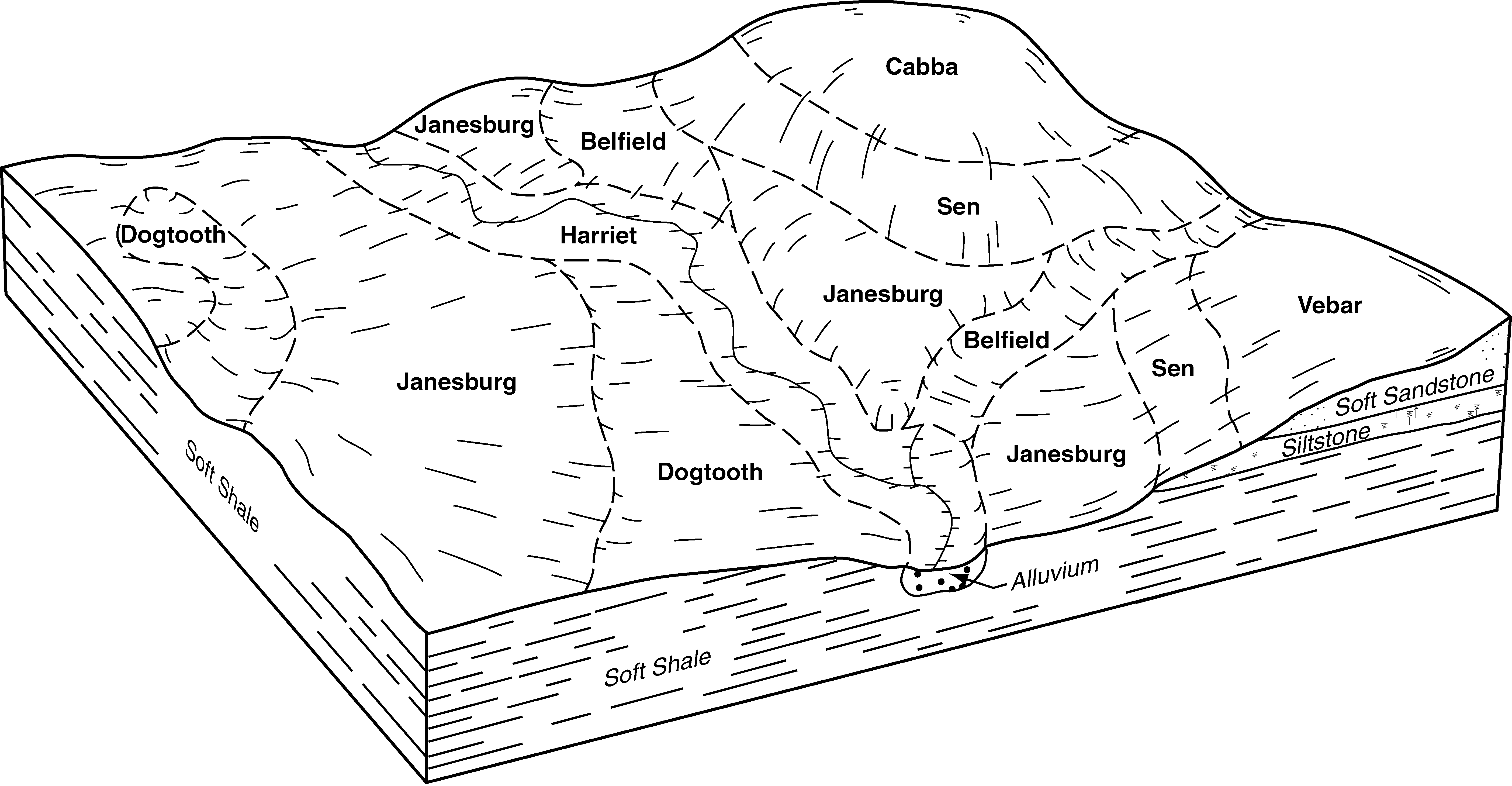
| Dogtooth-Janesburg-Cabba complex, 6 to 35 percent slopes | E0701F | 446 | 2992177 | 1vzry | mt109 | 1956 | 1:31680 |
Dogtooth-Janesburg-Cabba complex, 6 to 35 percent slopes | E0701F | 99 | 2755638 | 1vzry | nd001 | 1983 | 1:20000 |
Janesburg-Dogtooth complex, 0 to 6 percent slopes | E0563B | 45970 | 2699039 | 2r4gj | nd007 | 1998 | 1:24000 |
Dogtooth-Janesburg complex, 0 to 6 percent slopes | E0559B | 18138 | 2699038 | 2r4gh | nd007 | 1998 | 1:24000 |
Dogtooth-Janesburg-Cabba complex, 6 to 35 percent slopes | E0701F | 12693 | 1715170 | 1vzry | nd007 | 1998 | 1:24000 |
Dogtooth-Janesburg-Brandenburg complex, 9 to 35 percent slopes | E3021F | 5847 | 2707099 | 1vzvb | nd007 | 1998 | 1:24000 |
Dogtooth-Janesburg complex, 6 to 15 percent slopes | E0561D | 1827 | 1715161 | 1vzrh | nd007 | 1998 | 1:24000 |
Cedarpan-Dogtooth, barren, very stony-Farfeld complex, 3 to 35 percent slopes | E6039F | 879 | 2707119 | d1v1 | nd007 | 1998 | 1:24000 |
Dogtooth-Janesburg-Cabba complex, 6 to 35 percent slopes | E0701F | 1627 | 2563547 | 1vzry | nd011 | 1969 | 1:20000 |
Regent-Moreau-Dogtooth complex, 3 to 9 percent slopes | RlB | 288 | 992887 | 12b5m | nd011 | 1969 | 1:20000 |
Reeder-Dogtooth complex, 6 to 9 percent slopes | RdC | 184 | 992879 | 12b5c | nd011 | 1969 | 1:20000 |
Reeder-Dogtooth complex, 3 to 6 percent slopes | RdB | 127 | 992878 | 12b5b | nd011 | 1969 | 1:20000 |
Reeder-Dogtooth complex, 0 to 3 percent slopes | RdA | 42 | 992877 | 12b59 | nd011 | 1969 | 1:20000 |
Dogtooth-Janesburg-Cabba complex, 6 to 35 percent slopes | E0701F | 13179 | 2707180 | 1vzry | nd025 | 1981 | 1:20000 |
Janesburg-Dogtooth complex, 0 to 6 percent slopes | E0563B | 1181 | 2707171 | 2r4gj | nd025 | 1981 | 1:20000 |
Dogtooth-Janesburg complex, 0 to 6 percent slopes | E0559B | 457 | 2707170 | 2r4gh | nd025 | 1981 | 1:20000 |
Dogtooth-Janesburg complex, 6 to 15 percent slopes | E0561D | 107 | 2758468 | 1vzrh | nd025 | 1981 | 1:20000 |
Dogtooth-Janesburg silt loams, saline, 0 to 6 percent slopes | E0557B | 5 | 1713154 | 1vzrd | nd025 | 1981 | 1:20000 |
Dogtooth-Janesburg-Brandenburg complex, 9 to 35 percent slopes | E3021F | 2 | 2758484 | 1vzvb | nd025 | 1981 | 1:20000 |
Barkof-Wayden-Dogtooth complex, 3 to 9 percent slopes | E0725C | 4447 | 2707275 | 2r4gn | nd033 | 1985 | 1:24000 |
Brandenburg-Cabba-Dogtooth complex, 15 to 70 percent slopes | E3013F | 18 | 2759747 | cdts | nd033 | 1985 | 1:24000 |
Janesburg-Dogtooth complex, 0 to 6 percent slopes | E0563B | 6 | 2759730 | 2r4gj | nd033 | 1985 | 1:24000 |
Dogtooth-Janesburg-Cabba complex, 6 to 35 percent slopes | E0701F | 508 | 2759634 | 1vzry | nd037 | 1985 | 1:20000 |
Dogtooth-Janesburg-Cabba complex, 6 to 35 percent slopes | E0701F | 94 | 2755675 | 1vzry | nd041 | 1986 | 1:20000 |
Dogtooth-Janesburg-Cabba complex, 6 to 35 percent slopes | E0701F | 62591 | 2715039 | 1vzry | nd053 | 2003 | 1:24000 |
Brandenburg-Cabba-Dogtooth complex, 15 to 70 percent slopes | E3013F | 35774 | 2715087 | cdts | nd053 | 2003 | 1:24000 |
Dogtooth-Janesburg complex, 0 to 6 percent slopes | E0559B | 18436 | 2715033 | 2r4gh | nd053 | 2003 | 1:24000 |
Brandenburg-Searing-Dogtooth complex, 6 to 15 percent slopes | E3013D | 8738 | 2715086 | cdtr | nd053 | 2003 | 1:24000 |
Janesburg-Dogtooth complex, 0 to 6 percent slopes | E0563B | 4921 | 2715034 | 2r4gj | nd053 | 2003 | 1:24000 |
Dogtooth-Janesburg complex, 6 to 15 percent slopes | E0561D | 109 | 2759711 | 1vzrh | nd053 | 2003 | 1:24000 |
Dogtooth-Janesburg-Werner complex, 3 to 25 percent slopes | C593E | 6 | 2567157 | 2q6md | nd055 | 1974 | 1:20000 |
Dogtooth-Janesburg-Cabba complex, 6 to 35 percent slopes | E0701F | 1746 | 2699253 | 1vzry | nd057 | 1976 | 1:20000 |
Dogtooth-Janesburg-Cabba complex, 6 to 35 percent slopes | E0701F | 39847 | 1718334 | 1vzry | nd059 | 1998 | 1:20000 |
Dogtooth-Janesburg complex, 0 to 6 percent slopes | E0559B | 13706 | 1718328 | 2r4gh | nd059 | 1998 | 1:20000 |
Dogtooth-Janesburg-Cabba complex, 6 to 35 percent slopes | E0701F | 5365 | 2662512 | 1vzry | nd061 | 1988 | 1:24000 |
Dogtooth-Janesburg-Werner complex, 3 to 25 percent slopes | C593E | 2520 | 2566775 | 2q6md | nd061 | 1988 | 1:24000 |
Dogtooth-Janesburg complex, 6 to 15 percent slopes | E0561D | 14 | 2662510 | 1vzrh | nd061 | 1988 | 1:24000 |
Dogtooth-Janesburg-Cabba complex, 6 to 35 percent slopes | E0701F | 33 | 2755704 | 1vzry | nd065 | 1971 | 1:20000 |
Dogtooth-Janesburg complex, 0 to 6 percent slopes | E0559B | 32 | 2755703 | 2r4gh | nd065 | 1971 | 1:20000 |
Dogtooth-Janesburg-Regent complex, 6 to 15 percent slopes | E0705D | 21737 | 2699080 | d1x3 | nd085 | 1992 | 1:24000 |
Janesburg-Dogtooth complex, 0 to 6 percent slopes | E0563B | 16895 | 2699097 | 2r4gj | nd085 | 1992 | 1:24000 |
Janesburg-Dogtooth fine sandy loams, 0 to 6 percent slopes | E0569B | 11284 | 2699096 | d1xj | nd085 | 1992 | 1:24000 |
Dogtooth-Janesburg-Cabba complex, 6 to 35 percent slopes | E0701F | 7460 | 2699079 | 1vzry | nd085 | 1992 | 1:24000 |
Dogtooth-Janesburg-Cabba complex, 6 to 35 percent slopes | E0701F | 607 | 2758508 | 1vzry | nd087 | 1974 | 1:20000 |
Dogtooth-Janesburg complex, 0 to 6 percent slopes | E0559B | 98 | 2707366 | 2r4gh | nd087 | 1974 | 1:20000 |
Janesburg-Dogtooth complex, 0 to 6 percent slopes | E0563B | 16823 | 2715970 | 2r4gj | nd089 | 1965 | 1:20000 |
Dogtooth-Janesburg complex, 0 to 6 percent slopes | E0559B | 13447 | 2715969 | 2r4gh | nd089 | 1965 | 1:20000 |
Dogtooth-Janesburg-Cabba complex, 6 to 35 percent slopes | E0701F | 7215 | 2715976 | 1vzry | nd089 | 1965 | 1:20000 |
Brandenburg-Dogtooth-Janesburg complex, 0 to 15 percent slopes | E3015D | 775 | 2715997 | 1vzv9 | nd089 | 1965 | 1:20000 |
Dogtooth-Janesburg-Brandenburg complex, 9 to 35 percent slopes | E3021F | 688 | 1713546 | 1vzvb | nd089 | 1965 | 1:20000 |
Dogtooth-Janesburg complex, 6 to 15 percent slopes | E0561D | 586 | 1713458 | 1vzrh | nd089 | 1965 | 1:20000 |
Amor-Dogtooth-Janesburg loams, 3 to 25 percent slopes, very stony | E0711E | 375 | 2715977 | 1vzrz | nd089 | 1965 | 1:20000 |
Dogtooth-Janesburg silt loams, saline, 0 to 6 percent slopes | E0557B | 206 | 1713455 | 1vzrd | nd089 | 1965 | 1:20000 |
Dogtooth-Janesburg-Cabba complex, 6 to 35 percent slopes | DcE | 7273 | 2933133 | 1vzry | sd031 | 1986 | 1:24000 |
Dogtooth-Janesburg complex, 6 to 15 percent slopes | DjD | 825 | 2920818 | 1vzrh | sd031 | 1986 | 1:24000 |
Dogtooth-Janesburg complex, 6 to 15 percent slopes | DjD | 197 | 2920820 | 1vzrh | sd063 | 1984 | 1:24000 |