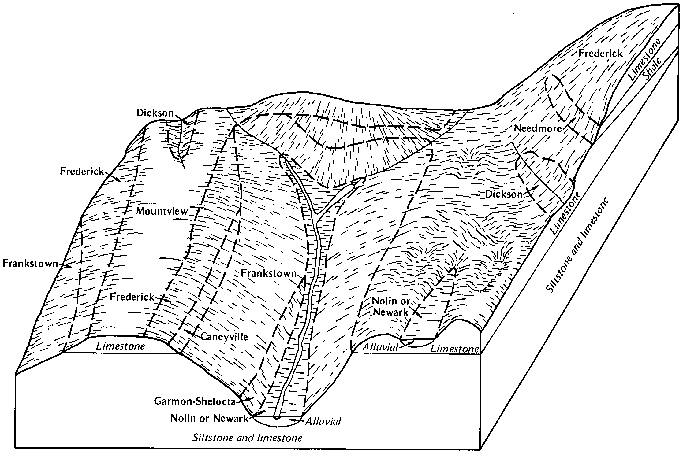
| Dickson silt loam, 0 to 2 percent slopes | DkA | 1715 | 328694 | 2t8fr | al033 | 1986 | 1:20000 |
Dickson silt loam, 2 to 5 percent slopes | DoB | 79182 | 523044 | 2sr6k | al077 | 1973 | 1:20000 |
Dickson silt loam, 6 to 10 percent slopes | DoC | 16160 | 523045 | kk8f | al077 | 1973 | 1:20000 |
Dickson silt loam, 0 to 2 percent slopes | DoA | 7964 | 523043 | 2t8fr | al077 | 1973 | 1:20000 |
Dickson silt loam, 2 to 5 percent slopes, eroded | Dle | 22716 | 522753 | 2s8mc | al083 | 1953 | 1:20000 |
Dickson silt loam, 0 to 2 percent slopes | Dlv | 17840 | 522756 | 2t8fr | al083 | 1953 | 1:20000 |
Dickson silt loam, 2 to 5 percent slopes | Dlu | 12853 | 522755 | 2sr6k | al083 | 1953 | 1:20000 |
Dickson cherty silt loam eroded rolling phase | Dcn | 3414 | 522747 | kjyt | al083 | 1953 | 1:20000 |
Dickson cherty silt loam eroded undulating phase | Dce | 2445 | 522746 | kjys | al083 | 1953 | 1:20000 |
Dickson cherty silt loam undulating phase | Dcu | 1139 | 522748 | kjyv | al083 | 1953 | 1:20000 |
Dickson silt loam eroded rolling phase | Dln | 1033 | 522754 | kjz1 | al083 | 1953 | 1:20000 |
Dickson cherty silt loam rolling phase | Dco | 841 | 522745 | kjyr | al083 | 1953 | 1:20000 |
Dickson cherty silty clay loam severely eroded rolling phase | Dkd | 248 | 522752 | kjyz | al083 | 1953 | 1:20000 |
Dickson silt loam, 2 to 5 percent slopes | Dt | 11550 | 523117 | 2sr6k | al089 | 1958 | 1:24000 |
Dickson silt loam, eroded, undulating | Du | 6124 | 523118 | kkbs | al089 | 1958 | 1:24000 |
Dickson cherty silt loam, eroded, undulating | Do | 4970 | 523113 | kkbm | al089 | 1958 | 1:24000 |
Dickson cherty silt loam, undulating | Dn | 3539 | 523112 | kkbl | al089 | 1958 | 1:24000 |
Dickson cherty silt loam, eroded, rolling | Dr | 3388 | 523115 | kkbp | al089 | 1958 | 1:24000 |
Dickson silt loam, 0 to 2 percent slopes | Ds | 2430 | 523116 | 2t8fr | al089 | 1958 | 1:24000 |
Dickson cherty silt loam, rolling | Dp | 1151 | 523114 | kkbn | al089 | 1958 | 1:24000 |
Dickson silt loam, 2 to 6 percent slopes | DkB | 4780 | 549759 | lg25 | ky169 | 1965 | 1:15840 |
Dickson silt loam, 6 to 12 percent slopes, eroded | DkC2 | 483 | 549761 | lg27 | ky169 | 1965 | 1:15840 |
Dickson silt loam, 0 to 2 percent slopes | DkA | 307 | 549758 | lg24 | ky169 | 1965 | 1:15840 |
Dickson silt loam, 2 to 6 percent slopes, eroded | DkB2 | 238 | 549760 | lg26 | ky169 | 1965 | 1:15840 |
Dickson silt loam, 2 to 6 percent slopes | DkB | 1248 | 550068 | lgd4 | ky231 | 1985 | 1:20000 |
Dickson silt loam, 2 to 6 percent slopes | DcB | 9219 | 552548 | ljz4 | ky620 | 1979 | 1:20000 |
Dickson silt loam, 2 to 6 percent slopes | DcB | 23279 | 2452977 | 2nbj9 | ky646 | 1966 | 1:15840 |
Dickson silt loam, 6 to 12 percent slopes, eroded | DcC2 | 4256 | 2452978 | 2nbjb | ky646 | 1966 | 1:15840 |
Dickson silt loam, 0 to 2 percent slopes | DcA | 863 | 2452976 | 2nbj8 | ky646 | 1966 | 1:15840 |
Dickson silt loam, 2 to 5 percent slopes | DkB | 18031 | 524421 | 2rgxr | tn015 | 1999 | 1:24000 |
Dickson silt loam, 5 to 12 percent slopes | DkC2 | 610 | 524422 | 2qh7h | tn015 | 1999 | 1:24000 |
Dickson silt loam, 2 to 5 percent slopes | DkB2 | 5799 | 527008 | 2rgxr | tn021 | 1991 | 1:24000 |
Dickson silt loam, 2 to 5 percent slopes | DkB2 | 957 | 531091 | 2rgxr | tn027 | 2002 | 1:24000 |
Dickson silt loam, 2 to 5 percent slopes | Dk | 45136 | 2749865 | 2rgxr | tn031 | 1956 | 1:20000 |
Dickson silt loam, 2 to 5 percent slopes | DkB | 2804 | 523415 | 2rgxr | tn037 | 1977 | 1:15840 |
Dickson silt loam, 5 to 12 percent slopes | Dk | 3295 | 2749891 | 2qh7h | tn039 | 2008 | 1:24000 |
Dickson silt loam, 2 to 5 percent slopes | Dl | 1306 | 2749867 | 2rgxr | tn039 | 2008 | 1:24000 |
Dickson silt loam, severely eroded rolling phase | Dm | 360 | 327290 | bzkr | tn039 | 2008 | 1:24000 |
Dickson silt loam, 2 to 5 percent slopes | DkB | 18036 | 527055 | 2rgxr | tn041 | 1968 | 1:15840 |
Dickson silt loam, 0 to 2 percent slopes | DkA | 1667 | 527054 | 2qh74 | tn041 | 1968 | 1:15840 |
Dickson silt loam, 2 to 5 percent slopes | DkB | 6393 | 527104 | 2rgxr | tn043 | 1993 | 1:24000 |
Dickson silt loam, 2 to 5 percent slopes, eroded | Dz | 12703 | 527196 | 2s8mc | tn051 | 1950 | 1:20000 |
Dickson silt loam, 2 to 5 percent slopes | Dy | 12468 | 527195 | 2wc0r | tn051 | 1950 | 1:20000 |
Dickson silt loam, eroded, rolling phase | D3 | 1676 | 527171 | kpkj | tn051 | 1950 | 1:20000 |
Dickson silt loam, rolling phase | D2 | 341 | 527170 | kpkh | tn051 | 1950 | 1:20000 |
Dickson silty clay loam, severely eroded, rolling phase | D4 | 90 | 527172 | kpkk | tn051 | 1950 | 1:20000 |
Dickson silt loam, 2 to 5 percent slopes | DnB | 2209 | 527303 | 2wc0r | tn055 | 1965 | 1:15840 |
Dickson silt loam, 2 to 5 percent slopes | DkB | 1851 | 527458 | 2rgxr | tn081 | 1997 | 1:24000 |
Dickson silt loam, 2 to 5 percent slopes | Da | 3245 | 2749871 | 2rgxr | tn083 | 1952 | 1:20000 |
Dickson silt loam, 5 to 12 percent slopes | Dc | 570 | 2749892 | 2qh7h | tn083 | 1952 | 1:20000 |
Dickson silt loam, shallow | Dls | 40366 | 527562 | kpz4 | tn085 | 1943 | 1:20000 |
Dickson silt loam, 2 to 5 percent slopes | Dl | 5445 | 527561 | 2rgxr | tn085 | 1943 | 1:20000 |
Dickson silt loam, 5 to 12 percent slopes | Dlx | 1683 | 527563 | 2qh7h | tn085 | 1943 | 1:20000 |
Dickson silt loam, 2 to 5 percent slopes | DkB2 | 1002 | 530186 | 2rgxr | tn087 | 1999 | 1:24000 |
Dickson silt loam, 5 to 12 percent slopes | DkC2 | 9 | 530187 | 2qh7h | tn087 | 1999 | 1:24000 |
Dickson silt loam, eroded gently sloping phase | Df | 8859 | 527635 | kq1h | tn099 | 1955 | 1:20000 |
Dickson silt loam, 2 to 5 percent slopes | De | 2890 | 527634 | 2wc0r | tn099 | 1955 | 1:20000 |
Dickson silt loam, eroded gently sloping dark brown surface phase | Dh | 971 | 527637 | kq1k | tn099 | 1955 | 1:20000 |
Dickson silt loam, level dark brown surface phase | Dg | 217 | 527636 | kq1j | tn099 | 1955 | 1:20000 |
Dickson silt loam, 2 to 5 percent slopes | DkB2 | 7123 | 530858 | 2rgxr | tn101 | 1999 | 1:24000 |
Dickson silt loam, 5 to 12 percent slopes | DkC2 | 202 | 530859 | 2qh7h | tn101 | 1999 | 1:24000 |
Dickson silt loam, 2 to 5 percent slopes | DkB | 26102 | 525822 | 2wc0r | tn103 | 1999 | 1:24000 |
Dickson silt loam, 5 to 12 percent slopes, eroded | DkC2 | 1217 | 525823 | kn51 | tn103 | 1999 | 1:24000 |
Dickson silt loam, 2 to 5 percent slopes | DkB2 | 16116 | 527700 | 2rgxr | tn111 | 1992 | 1:24000 |
Dickson silt loam, 2 to 5 percent slopes | De | 340 | 527761 | 2rgxr | tn119 | 1955 | 1:20000 |
Dickson silt loam, 2 to 5 percent slopes | DsB | 20302 | 527980 | 2rgxr | tn125 | 1972 | 1:15840 |
Dickson silt loam, 5 to 12 percent slopes | DsC | 2825 | 527981 | 2qh7h | tn125 | 1972 | 1:15840 |
Dickson silt loam, 2 to 5 percent slopes, western phase | DwB | 175 | 3436753 | 31pml | tn125 | 1972 | 1:15840 |
Dickson silt loam, 0 to 2 percent slopes | DsA | 21 | 3436752 | 31pmk | tn125 | 1972 | 1:15840 |
Dickson silt loam, 2 to 5 percent slopes | DkB | 2534 | 625734 | 2rgxr | tn127 | 2002 | 1:24000 |
Dickson silt loam, 0 to 2 percent slopes | DkA | 1081 | 625733 | 2qh74 | tn127 | 2002 | 1:24000 |
Dickson silt loam, 2 to 5 percent slopes | DkB2 | 2107 | 843365 | 2rgxr | tn133 | 2003 | 1:24000 |
Dickson silt loam, 2 to 5 percent slopes | DkB2 | 109 | 560616 | 2rgxr | tn135 | 2000 | 1:24000 |
Dickson silt loam, 2 to 5 percent slopes | DsB | 26921 | 528169 | 2rgxr | tn147 | 1965 | 1:15840 |
Dickson silt loam, 5 to 12 percent slopes | DsC2 | 1332 | 528170 | 2qh7h | tn147 | 1965 | 1:15840 |
Dickson silt loam, 5 to 12 percent slopes | Da | 22256 | 2396895 | 2qh7h | tn161 | 1953 | 1:20000 |
Dickson silt loam, 2 to 5 percent slopes | Db | 10890 | 2396896 | 2rgxr | tn161 | 1953 | 1:20000 |
Dickson silt loam, 0 to 2 percent slopes | Sa | 2389 | 2396968 | 2qh74 | tn161 | 1953 | 1:20000 |
Dickson-Gullied land complex, 2 to 12 percent slopes | Rd | 1924 | 2396961 | 2lg7b | tn161 | 1953 | 1:20000 |
Dickson silt loam, 2 to 5 percent slopes | DkB2 | 24594 | 528351 | 2rgxr | tn165 | 1993 | 1:20000 |
Dickson silt loam, 2 to 5 percent slopes | DkB | 20843 | 529879 | 2rgxr | tn177 | 1965 | 1:15840 |
Dickson silt loam, 2 to 5 percent slopes | DkB | 2417 | 328009 | 2wc0r | tn181 | 1996 | 1:24000 |
Dickson silt loam, 5 to 8 percent slopes | DkC | 624 | 328010 | c09z | tn181 | 1996 | 1:24000 |
Dickson silt loam, 2 to 5 percent slopes | DkB | 727 | 523493 | 2rgxr | tn187 | 1961 | 1:15840 |
Dickson silt loam, 2 to 5 percent slopes | DkB | 3322 | 528642 | 2rgxr | tn604 | 1974 | 1:20000 |
Dickson silt loam, 2 to 5 percent slopes | Dk | 4932 | 2427432 | 2rgxr | tn610 | 1960 | 1:15840 |
Bewleyville-Dickson complex, 2 to 6 percent slopes | BeB | 3100 | 2439166 | 2mw4s | tn701 | 1985 | 1:24000 |

