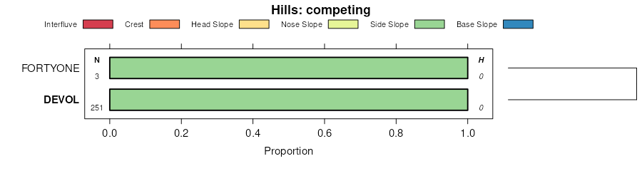
| Carwile, ponded-Devol complex, 0 to 3 percent slopes | CaB | 15636 | 381415 | dswq | ok003 | 1971 | 1:24000 |
Devol fine sandy loam, 0 to 3 percent slopes | AtB | 10384 | 381411 | 2sdbd | ok003 | 1971 | 1:24000 |
Devol loamy sand, 0 to 3 percent slopes | AsB | 9686 | 381410 | 2sdbh | ok003 | 1971 | 1:24000 |
Devol fine sandy loam, 3 to 5 percent slopes | AtC | 3769 | 381412 | 2sdbg | ok003 | 1971 | 1:24000 |
Devol fine sandy loam, silty substratum, 1 to 3 percent slopes | DvsB | 127 | 622538 | nwsw | ok003 | 1971 | 1:24000 |
Devol loamy sand, 3 to 8 percent slopes | DevD | 31 | 622537 | 2sdbl | ok003 | 1971 | 1:24000 |
Devol loamy sand, 0 to 3 percent slopes | 16 | 10533 | 381651 | 2sdbh | ok009 | 1978 | 1:24000 |
Devol loamy sand, 3 to 8 percent slopes | 17 | 9049 | 381652 | 2sdbl | ok009 | 1978 | 1:24000 |
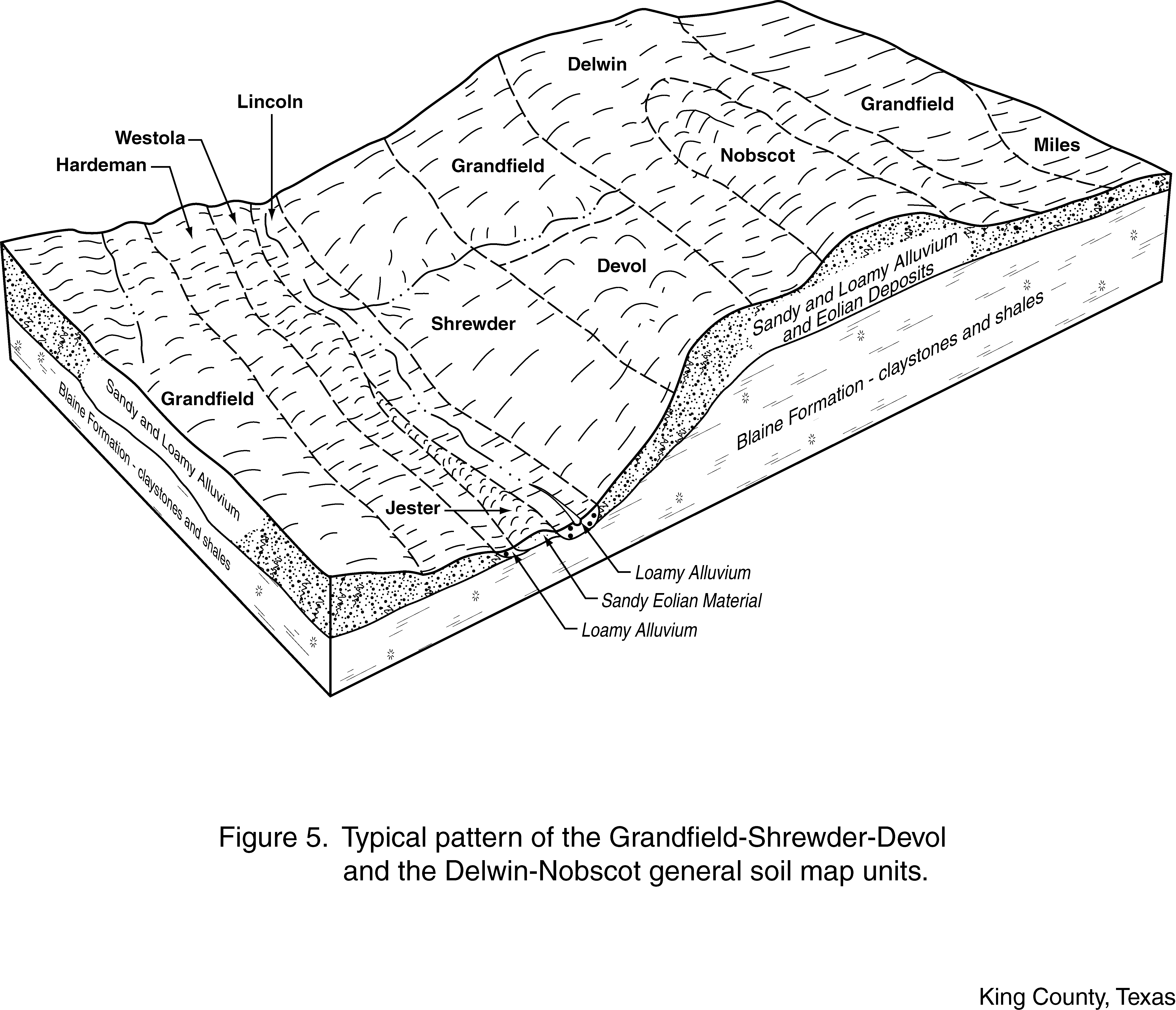
Devol-Grandfield complex, 3 to 12 percent slopes | 18 | 6438 | 381653 | dt4d | ok009 | 1978 | 1:24000 |
Devol fine sandy loam, 8 to 20 percent slopes | Sb | 8182 | 381768 | dt83 | ok011 | 1965 | 1:24000 |
Devol loamy sand, 0 to 3 percent slopes | ShB | 701 | 382247 | dtrk | ok033 | 1961 | 1:24000 |
Devol fine sandy loam, 3 to 5 percent slopes | DeC | 2026 | 382319 | 2sdbg | ok039 | 1973 | 1:24000 |
Devol fine sandy loam, 0 to 3 percent slopes | Ps | 5713 | 382389 | 2sdbd | ok043 | 1961 | 1:24000 |
Hardeman-Likes-Devol complex, 3 to 20 percent slopes | Br | 2153 | 382355 | 2tckm | ok043 | 1961 | 1:24000 |
Hardeman-Likes-Devol complex, 3 to 20 percent slopes | Bn | 35523 | 382422 | 2tckm | ok045 | 1963 | 1:24000 |
Devol fine sandy loam, 1 to 3 percent slopes | 2 | 13429 | 382707 | dv7d | ok053 | 1983 | 1:24000 |
Carwile, ponded-Devol complex, 0 to 3 percent slopes | 5 | 5793 | 382740 | dv8g | ok053 | 1983 | 1:24000 |
Devol fine sandy loam, 3 to 5 percent slopes | 3 | 2729 | 382718 | dv7r | ok053 | 1983 | 1:24000 |
Springer and Devol loamy sands, 0 to 3 percent slopes | SpDB | 10622 | 648152 | prg4 | ok055 | 2005 | 1:24000 |
Devol and Springer loamy sands, 3 to 8 percent slopes | DeSD | 5374 | 648153 | 30fpv | ok055 | 2005 | 1:24000 |
Springer and Devol loamy sands, 0 to 3 percent slopes | SpDB | 9243 | 975445 | 11r0z | ok057 | 1982 | 1:24000 |
Devol and Springer loamy sands, 3 to 8 percent slopes | DeSD | 6294 | 975446 | 30fpv | ok057 | 1982 | 1:24000 |
Devol loamy fine sand, 3 to 8 percent slopes, eroded | 16 | 4505 | 975447 | 11r11 | ok057 | 1982 | 1:24000 |
Devol fine sandy loam, 0 to 3 percent slopes | 17 | 652 | 975448 | 2sdbd | ok057 | 1982 | 1:24000 |
Devol fine sandy loam, 0 to 3 percent slopes | DvlB | 7876 | 382976 | 2sdbd | ok059 | 1998 | 1:24000 |
Devol fine sandy loam, 3 to 5 percent slopes | DvlC | 6465 | 382977 | 2sdbg | ok059 | 1998 | 1:24000 |
Grandfield-Devol-Grandmore complex, 5 to 12 percent slopes | GDGE | 2695 | 383187 | 30l07 | ok059 | 1998 | 1:24000 |
Devol fine sandy loam, 5 to 8 percent slopes | DvlD | 1309 | 382978 | dvj4 | ok059 | 1998 | 1:24000 |
Devol loamy fine sand, 8 to 12 percent slopes | DevE | 119 | 382979 | dvj5 | ok059 | 1998 | 1:24000 |
Springer and Devol loamy sands, 0 to 3 percent slopes | SpDB | 5585 | 392355 | f58m | ok065 | 2000 | 1:24000 |
Devol and Springer loamy sands, 3 to 8 percent slopes | DeSD | 1915 | 392356 | 30fpv | ok065 | 2000 | 1:24000 |
Devol loamy fine sand, 0 to 3 percent slopes | PfB | 26561 | 383407 | dvyz | ok073 | 1960 | 1:24000 |
Devol loamy fine sand, 3 to 8 percent slopes | PfC | 16527 | 383408 | dvz0 | ok073 | 1960 | 1:24000 |
Devol loamy sand, 0 to 3 percent slopes | DeB | 3241 | 383445 | 2sdbh | ok075 | 1973 | 1:24000 |
Devol fine sandy loam, 0 to 3 percent slopes | OrB | 3984 | 383844 | 2sdbd | ok093 | 1965 | 1:24000 |
Hardeman-Likes-Devol complex, 3 to 20 percent slopes | PcE | 30547 | 384759 | 2tckm | ok129 | 1961 | 1:24000 |
Grandfield-Devol complex, 3 to 5 percent slopes | MxC | 3021 | 384753 | 30l06 | ok129 | 1961 | 1:24000 |
Devol loamy sand, 3 to 8 percent slopes | SfC | 2905 | 384775 | 2sdbl | ok129 | 1961 | 1:24000 |
Devol loamy fine sand, 8 to 12 percent slopes | SfE | 2404 | 384776 | dxd4 | ok129 | 1961 | 1:24000 |
Devol fine sandy loam, 0 to 3 percent slopes | PsB | 2195 | 384764 | 2sdbd | ok129 | 1961 | 1:24000 |
Devol fine sandy loam, 3 to 5 percent slopes | PsC | 961 | 384765 | 2sdbg | ok129 | 1961 | 1:24000 |
Devol fine sandy loam, 0 to 1 percent slopes | PsA | 416 | 384763 | dxcq | ok129 | 1961 | 1:24000 |
Devol fine sandy loam, 5 to 8 percent slopes | PsD | 160 | 384766 | dxct | ok129 | 1961 | 1:24000 |
Devol fine sandy loam, 0 to 1 percent slopes | HaA | 14952 | 384951 | dxks | ok141 | 1968 | 1:24000 |
Devol loamy sand, 0 to 3 percent slopes | DeB | 12050 | 384941 | 2sdbh | ok141 | 1968 | 1:24000 |
Devol loamy sand, 3 to 8 percent slopes | DeC | 3760 | 384942 | 2sdbl | ok141 | 1968 | 1:24000 |
Devol-Grandfield complex, 0 to 3 percent slopes | 16 | 4616 | 384999 | dxmb | ok149 | 1976 | 1:24000 |
Devol-Grandfield complex, 3 to 8 percent slopes | 17 | 4561 | 385000 | dxmc | ok149 | 1976 | 1:24000 |
Devol loamy sand, 3 to 8 percent slopes | 15 | 3209 | 384998 | 2sdbl | ok149 | 1976 | 1:24000 |
Devol loamy sand, 0 to 3 percent slopes | 14 | 1359 | 384997 | 2sdbh | ok149 | 1976 | 1:24000 |
Devol loamy sand, 0 to 3 percent slopes | DevB | 12027 | 385172 | 2sdbh | ok151 | 1995 | 1:24000 |
Devol fine sandy loam, silty substratum, 1 to 3 percent slopes | DvsB | 10872 | 385177 | dxt2 | ok151 | 1995 | 1:24000 |
Devol loamy sand, 3 to 8 percent slopes | DevD | 6396 | 385173 | 2sdbl | ok151 | 1995 | 1:24000 |
Devol fine sandy loam, 3 to 5 percent slopes | DvlC | 6371 | 385176 | 2sdbg | ok151 | 1995 | 1:24000 |
Devol fine sandy loam, 0 to 3 percent slopes | DvlB | 4743 | 385175 | 2sdbd | ok151 | 1995 | 1:24000 |
Devol loamy fine sand, silty substratum, 3 to 8 percent slopes | DvvD | 2038 | 385178 | dxt3 | ok151 | 1995 | 1:24000 |
Hardeman-Devol complex, 8 to 20 percent slopes | EpE | 9090 | 385272 | 30yj4 | ok153 | 1961 | 1:24000 |
Devol fine sandy loam, 0 to 3 percent slopes | PbB | 7119 | 385290 | 2sdbd | ok153 | 1961 | 1:24000 |
Hardeman-Devol complex, 5 to 8 percent slopes | EpD | 5447 | 385271 | 30yj3 | ok153 | 1961 | 1:24000 |
Devol fine sandy loam, 3 to 8 percent slopes | PbC | 4985 | 385291 | dxxr | ok153 | 1961 | 1:24000 |
Devol loamy sand, 0 to 3 percent slopes | SfB | 10343 | 363840 | 2sdbh | tx075 | 1961 | 1:20000 |
Devol and Nobscot soils, severely eroded | Sn3 | 8394 | 363841 | d6lt | tx075 | 1961 | 1:20000 |
Devol and Nobscot soils, hummocky | SnD | 5769 | 363842 | d6lv | tx075 | 1961 | 1:20000 |
Devol loamy fine sand, 0 to 3 percent slopes | 13 | 4457 | 363864 | d6mk | tx077 | 1977 | 1:24000 |
Devol fine sand loam, 0 to 1 percent slopes | 15 | 3285 | 363866 | d6mm | tx077 | 1977 | 1:24000 |
Devol fine sandy loam, 1 to 3 percent slopes | 16 | 1815 | 363867 | d6mn | tx077 | 1977 | 1:24000 |
Devol loamy fine sand, 3 to 8 percent slopes | 14 | 633 | 363865 | d6ml | tx077 | 1977 | 1:24000 |
Devol loamy fine sand, undulating | SrB | 8861 | 364617 | d7dv | tx101 | 1969 | 1:20000 |
Devol loamy fine sand, hummocky | SrD | 4516 | 364618 | d7dw | tx101 | 1969 | 1:20000 |
Devol and Tivoli soils, hummocky | StD | 1608 | 364619 | d7dx | tx101 | 1969 | 1:20000 |
Devol loamy sand, 3 to 8 percent slopes | DeD | 511 | 3100899 | 2sdbl | tx155 | 2021 | 1:24000 |
Devol loamy sand, 0 to 3 percent slopes | SgB | 25818 | 367160 | 2sdbh | tx197 | 1965 | 1:20000 |
Devol loamy sand, 3 to 8 percent slopes | SgD | 9051 | 367161 | 2sdbl | tx197 | 1965 | 1:20000 |
Devol soils, severely eroded | Sp3 | 2496 | 367162 | db1y | tx197 | 1965 | 1:20000 |
Grandfield-Devol complex, 0 to 3 percent slopes | GrDB | 30979 | 2713438 | 2r5rw | tx207 | 1960 | 1:20000 |
Devol-Nobscot complex, 1 to 3 percent slopes | DeNB | 16688 | 2713435 | 2r5rx | tx207 | 1960 | 1:20000 |
Nobscot-Devol complex, 3 to 8 percent slopes | NoDC | 5055 | 2713443 | 2r5ry | tx207 | 1960 | 1:20000 |
Devol loamy sand, 3 to 8 percent slopes | DvD | 1881 | 368580 | dcjp | tx269 | 1999 | 1:31680 |
Grandfield-Devol complex, 0 to 3 percent slopes | GrDB | 21803 | 2713439 | 2r5rw | tx275 | 1975 | 1:24000 |
Devol-Nobscot complex, 1 to 3 percent slopes | DeNB | 5500 | 2713436 | 2r5rx | tx275 | 1975 | 1:24000 |
Devol loamy fine sand, 3 to 8 percent slopes, dry | DeD | 52819 | 369450 | 2w83v | tx295 | 1971 | 1:24000 |
Devol and Springer soils, undulating, severely eroded | DsC3 | 740 | 369451 | ddfs | tx295 | 1971 | 1:24000 |
Devol loamy fine sand, 3 to 8 percent slopes | DoD | 13358 | 370857 | dfx4 | tx345 | 1972 | 1:24000 |
Devol and Tivoli soils, 1 to 8 percent slopes | DtD | 1495 | 370858 | dfx5 | tx345 | 1972 | 1:24000 |
Devol loamy fine sand, 3 to 8 percent slopes, dry | DeD | 4395 | 371510 | 2w83v | tx393 | 1979 | 1:24000 |
Devol loamy fine sand, 0 to 3 percent slopes | DeB | 6861 | 372269 | dhcp | tx433 | 1970 | 1:24000 |
Grandfield-Devol complex, 0 to 3 percent slopes | GrDB | 324 | 2713440 | 2r5rw | tx433 | 1970 | 1:24000 |
Devol-Nobscot complex, 1 to 3 percent slopes | DeNB | 69 | 2713437 | 2r5rx | tx433 | 1970 | 1:24000 |
Devol loamy sand, 3 to 8 percent slopes | DlD | 67213 | 373291 | 2sdbl | tx483 | 1970 | 1:24000 |
Devol loamy sand, 0 to 3 percent slopes | DlB | 34917 | 373290 | 2sdbh | tx483 | 1970 | 1:24000 |
Devol soils, undulating, severely eroded | DmC3 | 18616 | 373292 | djfp | tx483 | 1970 | 1:24000 |
Devol loamy fine sand, 0 to 3 percent slopes | DvB | 980 | 373347 | djhg | tx485 | 1972 | 1:20000 |