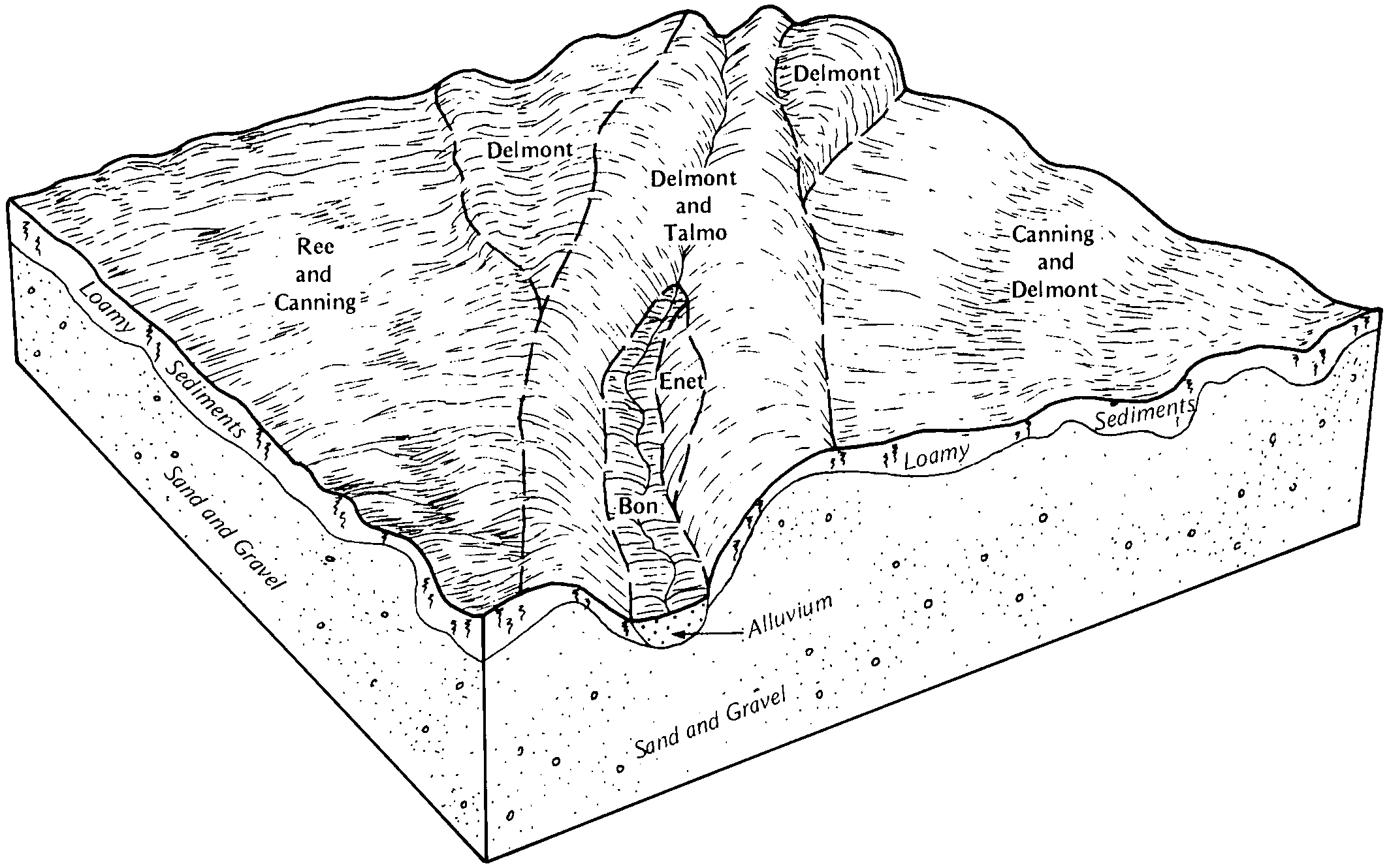
| Delmont-Enet loams, 2 to 6 percent slopes | DmB | 10395 | 354841 | 2wkr4 | sd003 | 1979 | 1:20000 |
Delmont-Enet loams, 0 to 2 percent slopes | DmA | 2581 | 354840 | 2wkr3 | sd003 | 1979 | 1:20000 |
Delmont-Talmo complex, 6 to 15 percent slopes | DnC | 2562 | 354842 | cx7j | sd003 | 1979 | 1:20000 |
Talmo-Delmont complex, 15 to 40 percent slopes | TdE | 399 | 354868 | cx8c | sd003 | 1979 | 1:20000 |
Delmont loam, 0 to 2 percent slopes | DeA | 6175 | 354561 | 2wkr5 | sd005 | 1976 | 1:20000 |
Delmont-Talmo complex, 2 to 6 percent slopes | DfB | 3639 | 354562 | cwyh | sd005 | 1976 | 1:20000 |
Delmont-Enet loams, 2 to 6 percent slopes | EdB | 1654 | 418265 | 2wkr4 | sd009 | 1981 | 1:20000 |
Delmont-Enet loams, 0 to 2 percent slopes | EdA | 1630 | 418264 | 2wkr3 | sd009 | 1981 | 1:20000 |
Talmo-Delmont loams, 15 to 40 percent slopes | TaE | 589 | 418287 | g184 | sd009 | 1981 | 1:20000 |
Delmont-Talmo loams, 6 to 9 percent slopes | DlC | 273 | 418258 | g176 | sd009 | 1981 | 1:20000 |
Enet-Delmont loams, 2 to 9 percent slopes | EnC | 1180 | 355023 | cxfc | sd023 | 1980 | 1:20000 |
Delmont-Talmo complex, 2 to 9 percent slopes | DmC | 1063 | 355014 | cxf2 | sd023 | 1980 | 1:20000 |
Delmont-Enet loams, 2 to 6 percent slopes | DeB | 128 | 417716 | 2wkr4 | sd025 | 1992 | 1:20000 |
Delmont-Enet loams, 0 to 2 percent slopes | DeA | 18 | 417715 | 2wkr3 | sd025 | 1992 | 1:20000 |
Delmont-Enet loams, 2 to 6 percent slopes | DmB | 849 | 445545 | 316sr | sd027 | 1995 | 1:24000 |
Delmont-Talmo complex, 6 to 15 percent slopes | DnD | 54 | 445546 | gymg | sd027 | 1995 | 1:24000 |
Delmont loam, 2 to 6 percent slopes | DmB | 1532 | 352913 | 2wkr6 | sd035 | 1966 | 1:20000 |
Delmont-Enet loams, 0 to 2 percent slopes | EoA | 1306 | 352915 | 2wkr3 | sd035 | 1966 | 1:20000 |
Delmont-Enet loams, 2 to 6 percent slopes | EoB | 850 | 352916 | 2wkr4 | sd035 | 1966 | 1:20000 |
Delmont-Enet loams, 0 to 2 percent slopes | EdA | 3461 | 354895 | 2wkr3 | sd043 | 1979 | 1:20000 |
Delmont-Talmo loams, 2 to 9 percent slopes | DmC | 1648 | 354890 | cx92 | sd043 | 1979 | 1:20000 |
Delmont-Enet loams, 2 to 6 percent slopes | DlB | 965 | 354889 | 2wkr4 | sd043 | 1979 | 1:20000 |
Delmont loam, 0 to 2 percent slopes | DeA | 659 | 354888 | 2wkr5 | sd043 | 1979 | 1:20000 |
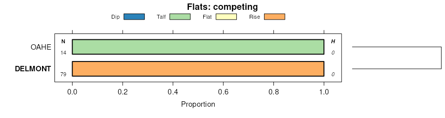
Oahe-Delmont loams, 2 to 6 percent slopes | LeB | 65 | 354268 | 2wkpk | sd045 | 1973 | 1:20000 |
Delmont-Enet loams, 2 to 6 percent slopes | LhB | 29 | 354269 | 2wkr4 | sd045 | 1973 | 1:20000 |
Oahe-Delmont loams, 0 to 2 percent slopes | LeA | 26 | 354267 | 2wkpj | sd045 | 1973 | 1:20000 |
Delmont loam, 0 to 2 percent slopes | LeA | 355 | 355175 | 2wkr5 | sd049 | 1981 | 1:20000 |
Delmont loam, 2 to 6 percent slopes | LeB | 287 | 355176 | 2wkr6 | sd049 | 1981 | 1:20000 |
Delmont-Talmo loams, 6 to 9 percent slopes | DtC | 53 | 3466277 | 30t3v | sd049 | 1981 | 1:20000 |
Oahe-Delmont loams, 2 to 6 percent slopes | So | 4538 | 352679 | 2wkpk | sd059 | 1959 | 1:20000 |
Glenham-Delmont loams, rolling | WuC | 1985 | 352699 | cv0d | sd059 | 1959 | 1:20000 |
Delmont loam, 0 to 2 percent slopes | Sm | 1949 | 352678 | 2wkr5 | sd059 | 1959 | 1:20000 |
Delmont-Enet loams, 2 to 6 percent slopes | Sw | 1614 | 352680 | 2wkr4 | sd059 | 1959 | 1:20000 |
Oahe-Delmont loams, 0 to 2 percent slopes | OhA | 1438 | 352656 | 2wkpj | sd059 | 1959 | 1:20000 |
Delmont-Enet loams, 0 to 2 percent slopes | WgA | 654 | 352687 | 2wkr3 | sd059 | 1959 | 1:20000 |
Glenham-Delmont loams, undulating | WuB | 349 | 352698 | cv0c | sd059 | 1959 | 1:20000 |
Houdek-Delmont loams, rolling | HsC | 343 | 352624 | 2yyhb | sd059 | 1959 | 1:20000 |
Houdek-Delmont loams, undulating | HsB | 3 | 352623 | 2yyh9 | sd059 | 1959 | 1:20000 |
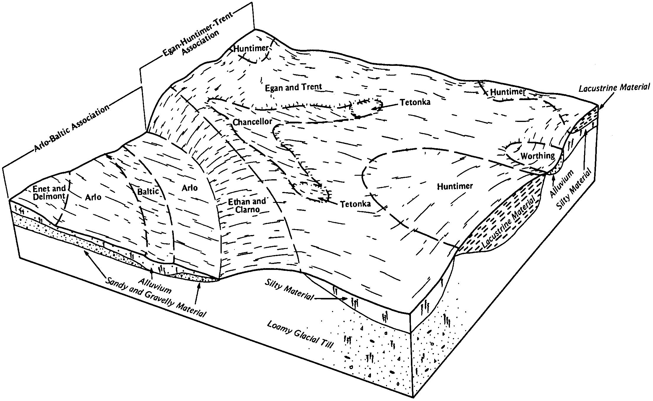
Oahe-Delmont loams, 2 to 6 percent slopes | DnB | 5639 | 353791 | 2wkpk | sd069 | 1992 | 1:20000 |
Talmo-Delmont loams, 3 to 15 percent slopes | TdD | 4236 | 353853 | cw6m | sd069 | 1992 | 1:20000 |
Oahe-Delmont loams, 0 to 2 percent slopes | OaA | 2154 | 353822 | 2wkpj | sd069 | 1992 | 1:20000 |
Delmont-Enet loams, 2 to 6 percent slopes | EpB | 2804 | 356429 | 2wkr4 | sd073 | 1987 | 1:20000 |
Delmont-Talmo loams, 9 to 20 percent slopes | DmD | 2739 | 356422 | cywh | sd073 | 1987 | 1:20000 |
Delmont-Ethan loams, 9 to 20 percent slopes | DkD | 2336 | 356421 | cywg | sd073 | 1987 | 1:20000 |
Delmont loam, 6 to 9 percent slopes | DeC | 1767 | 356419 | cywd | sd073 | 1987 | 1:20000 |
Canning-Delmont loams, 2 to 6 percent slopes | CdB | 1648 | 356411 | cyw4 | sd073 | 1987 | 1:20000 |
Delmont-Enet loams, 0 to 2 percent slopes | DgA | 796 | 356420 | 2wkr3 | sd073 | 1987 | 1:20000 |
Delmont-Talmo loams, 2 to 6 percent slopes | DtB | 1428 | 417473 | g0dw | sd077 | 1992 | 1:20000 |
Delmont loam, 0 to 2 percent slopes | DeA | 1004 | 417472 | 2wkr5 | sd077 | 1992 | 1:20000 |
Talmo-Delmont loams, 6 to 15 percent slopes | TdD | 163 | 417517 | g0g9 | sd077 | 1992 | 1:20000 |
Delmont-Talmo loams, 2 to 6 percent slopes | DeB | 1138 | 416481 | fzcw | sd079 | 1967 | 1:20000 |
Talmo-Delmont loams, 6 to 21 percent slopes | TdE | 1041 | 416516 | fzf0 | sd079 | 1967 | 1:20000 |
Dempster-Delmont complex, 6 to 9 percent slopes | DpC | 495 | 416485 | fzd0 | sd079 | 1967 | 1:20000 |
Delmont-Talmo loams, 6 to 9 percent slopes | DeC | 451 | 416482 | fzcx | sd079 | 1967 | 1:20000 |
Delmont-Graceville complex, 2 to 6 percent slopes | DgB | 2211 | 416634 | fzjt | sd083 | 1971 | 1:20000 |
Delmont and Talmo soils, 2 to 9 percent slopes | DkB | 1291 | 416635 | fzjv | sd083 | 1971 | 1:20000 |
Delmont loam, 2 to 6 percent slopes | DeB | 919 | 416633 | 316sk | sd083 | 1971 | 1:20000 |
Delmont loam, 0 to 2 percent slopes | DeA | 394 | 416632 | 2zp2y | sd083 | 1971 | 1:20000 |
Delmont loam, 2 to 6 percent slopes | DeB | 4624 | 418022 | 2wkr6 | sd087 | 1976 | 1:20000 |
Delmont-Enet loams, 0 to 2 percent slopes | DnA | 2494 | 418023 | 2wkr3 | sd087 | 1976 | 1:20000 |
Delmont-Enet loams, 0 to 2 percent slopes | EdA | 9321 | 355397 | 2wkr3 | sd097 | 1983 | 1:20000 |
Delmont-Talmo complex, 6 to 9 percent slopes | DgC | 1098 | 446023 | gz3v | sd099 | 1995 | 1:24000 |
Delmont-Enet loams, 2 to 6 percent slopes | DeB | 1074 | 446022 | 316sr | sd099 | 1995 | 1:24000 |
Delmont-Enet loams, 0 to 2 percent slopes | DeA | 797 | 446021 | 316sp | sd099 | 1995 | 1:24000 |
Delmont-Talmo complex, 9 to 15 percent slopes | DgD | 725 | 446024 | gz3w | sd099 | 1995 | 1:24000 |
Talmo-Delmont complex, 15 to 40 percent slopes | TdE | 150 | 446079 | gz5n | sd099 | 1995 | 1:24000 |
Delmont-Talmo complex, 6 to 40 percent slopes | DgD | 168 | 418314 | g190 | sd101 | 1985 | 1:20000 |
Delmont loam, 0 to 2 percent slopes | DeA | 94 | 418313 | 2zp2y | sd101 | 1985 | 1:20000 |
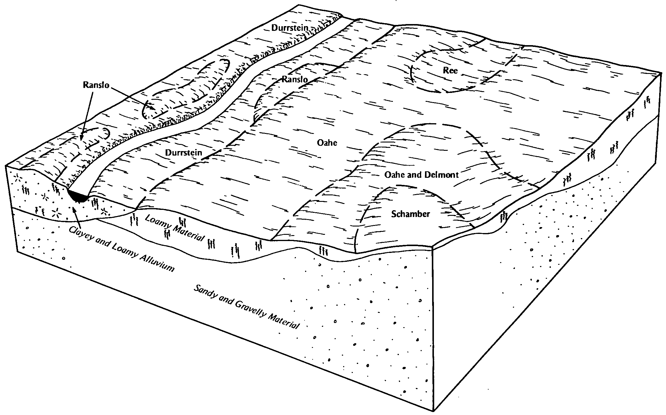
Oahe-Delmont loams, 0 to 2 percent slopes | OaA | 11847 | 355351 | 2wkpj | sd107 | 1983 | 1:20000 |
Oahe-Delmont loams, 2 to 6 percent slopes | OdB | 3181 | 355353 | 2wkpk | sd107 | 1983 | 1:20000 |
Delmont-Schamber complex, 6 to 15 percent slopes | DsD | 1742 | 355321 | cxqz | sd107 | 1983 | 1:20000 |
Delmont-Enet loams, 2 to 6 percent slopes | EdB | 3210 | 354784 | 2wkr4 | sd111 | 1978 | 1:20000 |
Delmont loam, 0 to 2 percent slopes | DdA | 638 | 354775 | 2wkr5 | sd111 | 1978 | 1:20000 |
Delmont-Enet loams, 0 to 2 percent slopes | DeA | 4083 | 356586 | 2wkr3 | sd115 | 1997 | 1:24000 |
Oahe-Delmont loams, 0 to 2 percent slopes | OaA | 3489 | 353097 | 2wkpj | sd119 | 1967 | 1:20000 |
Oahe-Delmont loams, 2 to 6 percent slopes | OaB | 1366 | 353098 | 2wkpk | sd119 | 1967 | 1:20000 |
Delmont-Enet loams, high precipitation, 0 to 2 percent slopes | DlA | 12013 | 3082507 | 2xhdj | sd125 | 1980 | 1:20000 |
Delmont-Enet loams, high precipitation, 2 to 6 percent slopes | DehB | 4077 | 3082553 | 2xhdk | sd125 | 1980 | 1:20000 |
Delmont-Enet loams, 2 to 6 percent slopes | DeB | 1059 | 418224 | 2wkr4 | sd125 | 1980 | 1:20000 |
Delmont-Enet loams, 0 to 2 percent slopes | DeA | 360 | 418223 | 2wkr3 | sd125 | 1980 | 1:20000 |
Oahe-Delmont loams, 2 to 6 percent slopes | LaB | 1732 | 354505 | 2wkpk | sd129 | 1975 | 1:20000 |
Oahe-Delmont loams, 0 to 2 percent slopes | LaA | 986 | 354504 | 2wkpj | sd129 | 1975 | 1:20000 |
Delmont-Enet loams, 0 to 2 percent slopes | EhA | 1341 | 418078 | 2wkr3 | sd135 | 1977 | 1:20000 |
Delmont-Enet loams, 2 to 6 percent slopes | EhB | 944 | 418079 | 2wkr4 | sd135 | 1977 | 1:20000 |
Delmont-Enet loams, high precipitation, 0 to 2 percent slopes | DlA | 16 | 3082509 | 2xhdj | sd135 | 1977 | 1:20000 |
Delmont-Enet loams, high precipitation, 2 to 6 percent slopes | EhhB | 6 | 3082555 | 2xhdk | sd135 | 1977 | 1:20000 |
Delmont loam, 2 to 6 percent slopes | DeB | 4485 | 417955 | 2wkr6 | sd602 | 1975 | 1:20000 |
Delmont loam, 0 to 2 percent slopes | DeA | 3706 | 417954 | 2wkr5 | sd602 | 1975 | 1:20000 |
Delmont-Talmo complex, 6 to 12 percent slopes | DnD | 1509 | 417957 | g0xh | sd602 | 1975 | 1:20000 |
Delmont-Rock outcrop complex, 2 to 9 percent slopes | DmB | 433 | 417956 | g0xg | sd602 | 1975 | 1:20000 |
Oahe-Delmont loams, 2 to 6 percent slopes | OdB | 6182 | 355527 | 2wkpk | sd603 | 1983 | 1:20000 |
Delmont loam, 6 to 15 percent slopes | DeD | 4203 | 355494 | cxxk | sd603 | 1983 | 1:20000 |
Oahe-Delmont loams, 0 to 2 percent slopes | Oa | 2179 | 355526 | 2wkpj | sd603 | 1983 | 1:20000 |