| Loxley, Dawson, and Greenwood peats, 0 to 1 percent slopes | LoxaaA | 15181 | 1455282 | 3110p | mi003 | 2007 | 1:24000 |
Rousseau-Dawson complex, 0 to 15 percent slopes | 109D | 192 | 1455310 | 1kvch | mi003 | 2007 | 1:24000 |
Rousseau-Dawson complex, 0 to 60 percent slopes | 109F | 78 | 1455311 | 1kvcj | mi003 | 2007 | 1:24000 |
Dawson peat | 128 | 251 | 191323 | 6f2q | mi007 | 1998 | 1:12000 |
Dawson-Loxley peats | 14 | 2 | 191353 | 6f3p | mi007 | 1998 | 1:12000 |
Dawson-Greenwood peats | Dg | 195 | 189145 | 6btg | mi011 | 1964 | 1:20000 |
Dawson, Greenwood, and Loxley soils. 0 to 1 percent slopes | 19 | 11193 | 414955 | fxsn | mi013 | 1984 | 1:20000 |
Dawson peat | 10 | 1831 | 190519 | 6d7s | mi031 | 1988 | 1:15840 |
Loxley, Dawson, and Greenwood peats, 0 to 1 percent slopes | LoxaaA | 26613 | 415144 | 3110p | mi033 | 1989 | 1:15840 |
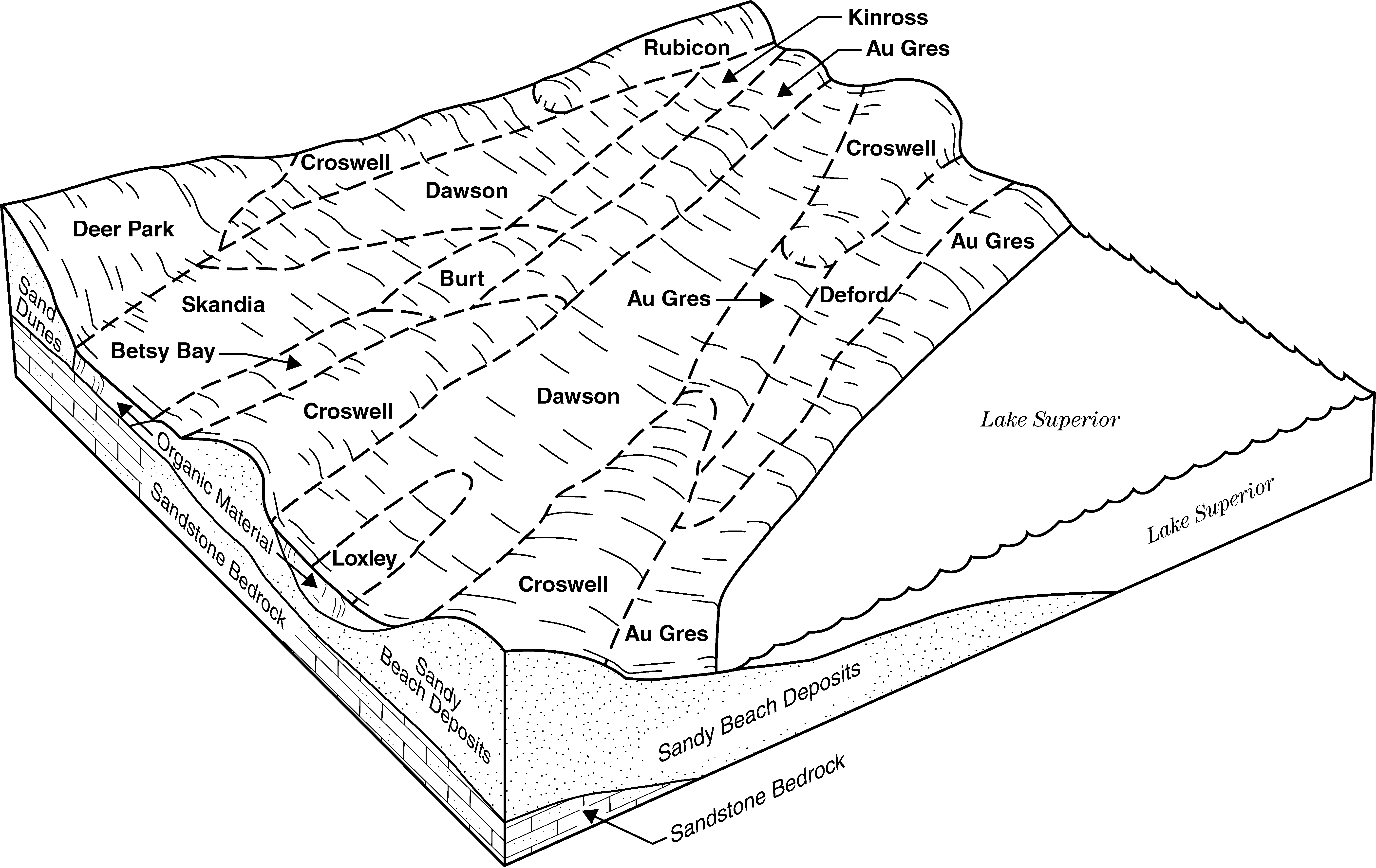
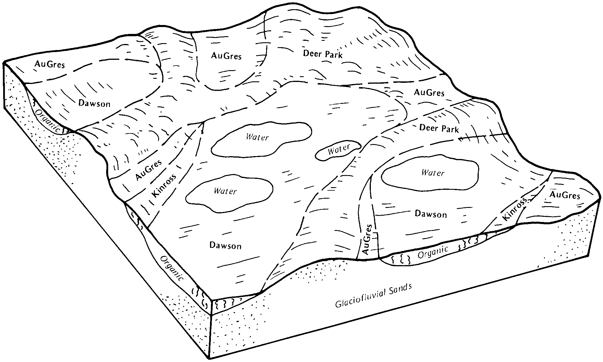
Au Gres-Dawson-Rubicon complex, 0 to 15 percent slopes | 39D | 8627 | 415146 | fxzt | mi033 | 1989 | 1:15840 |
Kinross-Dawson complex | 102 | 5056 | 415054 | fxwv | mi033 | 1989 | 1:15840 |
Dawson-Deer Park-Wainola complex, 0 to 50 percent slopes | 154F | 2662 | 415112 | fxyq | mi033 | 1989 | 1:15840 |
Dawson-Loxley peats | 14 | 1805 | 189656 | 6cby | mi039 | 1993 | 1:15840 |
Loxley, Dawson, and Greenwood peats, 0 to 1 percent slopes | LoxaaA | 26473 | 1588037 | 3110p | mi041 | 1969 | 1:24000 |
Loxley and Dawson peats, 0 to 1 percent slopes | 417A | 99 | 1588059 | 3110q | mi041 | 1969 | 1:24000 |
Greenwood and Dawson peats | 17 | 3332 | 3385771 | fy1k | mi043 | 1985 | 1:20000 |
Loxley and Dawson peats, 0 to 1 percent slopes | 417A | 1259 | 415200 | 3110q | mi043 | 1985 | 1:20000 |
Loxley, Greenwood, and Dawson peats, 0 to 1 percent slopes | 418A | 12938 | 1456367 | 3110n | mi053 | 2007 | 1:24000 |
Dawson, Greenwood and Loxley soils, 0 to 1 percent slopes | 26 | 8766 | 416113 | fz00 | mi061 | 1989 | 1:20000 |
Dawson-Kinross complex, 0 to 1 percent slopes | 125 | 1006 | 416059 | fyy8 | mi061 | 1989 | 1:20000 |
Dawson peat | 128 | 1113 | 191709 | 6fh5 | mi069 | 1995 | 1:15840 |
Dawson, Greenwood, and Loxley soils, 0 to 1 percent slopes | 28 | 6944 | 2450856 | 2n89w | mi071 | 1992 | 1:20000 |
Dawson-Loxley peats | 14 | 2109 | 190627 | 6dc8 | mi079 | 1998 | 1:12000 |
Loxley, Dawson, and Greenwood peats, 0 to 1 percent slopes | LoxaaA | 44295 | 399629 | 3110p | mi095 | 2004 | 1:24000 |
Spot-Dawson peats | 102 | 9442 | 631297 | p5xf | mi095 | 2004 | 1:24000 |
Rousseau-Dawson complex, 0 to 60 percent slopes | 109F | 2664 | 631299 | p5xh | mi095 | 2004 | 1:24000 |
Au Gres-Dawson-Rubicon complex, 0 to 15 percent slopes | 110D | 2534 | 631300 | p5xj | mi095 | 2004 | 1:24000 |
Rousseau-Dawson complex, 0 to 15 percent slopes | 109D | 1483 | 631298 | p5xg | mi095 | 2004 | 1:24000 |
Au Gres-Dawson-Rubicon complex, 0 to 35 percent slopes | 110E | 287 | 631301 | p5xk | mi095 | 2004 | 1:24000 |
Loxley, Dawson, and Greenwood peats, 0 to 1 percent slopes | LoxaaA | 9681 | 416397 | 3110p | mi097 | 1994 | 1:20000 |
Finch-Dawson-Pullup complex, 0 to 35 percent slopes | 39E | 7016 | 416399 | fz97 | mi097 | 1994 | 1:20000 |
Greenwood and Dawson soils | 58 | 14113 | 3385784 | f88k | mi103 | 1999 | 1:24000 |
Loxley, Dawson, and Greenwood peats, 0 to 1 percent slopes | LoxaaA | 6415 | 3385782 | 3110p | mi103 | 1999 | 1:24000 |
Loxley and Dawson peats, 0 to 1 percent slopes | 417A | 2368 | 395236 | 3110q | mi103 | 1999 | 1:24000 |
Loxley and Dawson soils | 81 | 821 | 192604 | 6gf1 | mi105 | 1992 | 1:15840 |
Loxley, Dawson, and Greenwood peats, 0 to 1 percent slopes | LoxaaA | 5242 | 3385786 | 3110p | mi109 | 1985 | 1:20000 |
Loxley and Dawson peats, 0 to 1 percent slopes | 417A | 3451 | 415457 | 3110q | mi109 | 1985 | 1:20000 |
Dawson-Loxley peats | 14 | 987 | 192190 | 6fzp | mi119 | 1997 | 1:12000 |
Dawson peat | 71 | 428 | 189943 | 6cn6 | mi129 | 1987 | 1:15840 |
Dawson, Greenwood, and Loxley soils, 0 to 1 percent slopes | 46A | 2420 | 1456433 | 1kwjq | mi131 | 2007 | 1:24000 |
Dawson-Kinross complex, 0 to 1 percent slopes | 8157 | 1221 | 1674846 | 1t6t9 | mi131 | 2007 | 1:24000 |
Dawson peaty muck | Da | 227 | 190014 | 6cqh | mi133 | 1966 | 1:15840 |
Dawson-Loxley peats | 14 | 856 | 241377 | 835c | mi135 | 2003 | 1:12000 |
Dawson-Loxley peats | 14 | 1698 | 191443 | 6f6l | mi137 | 1998 | 1:12000 |
Dawson peat | 62 | 813 | 190926 | 6dnx | mi141 | 1989 | 1:15840 |
Dawson-Loxley peats | 14 | 7378 | 190979 | 6dqm | mi143 | 1999 | 1:12000 |
Dawson-Kinross complex | 499 | 218 | 191047 | 6dst | mi143 | 1999 | 1:12000 |
Loxley, Dawson, and Greenwood peats, 0 to 1 percent slopes | LoxaaA | 30949 | 1456947 | 3110p | mi153 | 2007 | 1:24000 |
Dawson-Kinross complex | 84 | 4111 | 1456920 | 1kx1f | mi153 | 2007 | 1:24000 |
Deer Park-Dawson-Wainola complex, 0 to 60 percent slopes | 80F | 995 | 1610311 | 1r1nj | mi153 | 2007 | 1:24000 |
Dawson and Loxley soils, 0 to 1 percent slopes | 3 | 2500 | 435345 | gm0d | mi605 | 2004 | 1:24000 |
Dawson-Croswell complex, 0 to 8 percent slopes | 15B | 1240 | 800735 | vw75 | mi605 | 2004 | 1:24000 |
Dawson muck | 536 | 10020 | 396377 | f9gc | mn017 | 1973 | 1:20000 |
Colton-Duxbury-Dawson complex, 15 to 35 percent slopes | 380D | 42 | 2679499 | 9wv5 | ny033 | 2018 | 1:24000 |
Dawson-Fluvaquents-Loxley complex, frequently flooded | 021 | 5 | 2679497 | 9wtv | ny033 | 2018 | 1:24000 |
Dawson-Fluvaquents-Loxley complex, frequently flooded | 21A | 4707 | 291941 | 9ssg | ny041 | 1994 | 1:62500 |
Loxley-Dawson complex | 23A | 558 | 291942 | 9ssh | ny041 | 1994 | 1:62500 |
Colton-Duxbury-Dawson complex, 0 to 15 percent slopes | 380B | 76 | 2677573 | 9wv4 | ny043 | 2018 | 1:24000 |
Dawson-Fluvaquents-Loxley complex, frequently flooded | 21A | 4 | 2677610 | 9ssg | ny043 | 2018 | 1:24000 |
Dawson peat | 398 | 4 | 2677594 | 9vb5 | ny043 | 2018 | 1:24000 |
Tunbridge-Lyman-Dawson complex, 3 to 15 percent slopes, very rocky, very bouldery | TwC | 16 | 2753699 | 2wrc1 | ny049 | 2018 | 1:24000 |
Dawson peat | 398 | 2683 | 293420 | 9vb5 | ny065 | 1993 | 1:24000 |
Dawson-Fluvaquents-Loxley complex, frequently flooded | 021 | 43097 | 294867 | 9wtv | ny089 | 1990 | 1:24000 |
Tunbridge-Lyman-Dawson complex, 3 to 15 percent slopes, very rocky, very bouldery | TwC | 26814 | 295028 | 2wrc1 | ny089 | 1990 | 1:24000 |
Colton-Duxbury-Dawson complex, 15 to 35 percent slopes | 380D | 18376 | 294877 | 9wv5 | ny089 | 1990 | 1:24000 |
Loxley-Dawson complex | 023 | 15492 | 294868 | 9wtw | ny089 | 1990 | 1:24000 |
Colton-Duxbury-Dawson complex, 0 to 15 percent slopes | 380B | 12997 | 294876 | 9wv4 | ny089 | 1990 | 1:24000 |
Dawson peat | Da | 604 | 294928 | 9wwt | ny089 | 1990 | 1:24000 |
Dawson, Greenwood, and Loxley soils, 0 to 1 percent slopes | 5140A | 2917 | 1702827 | 1v4xx | wi003 | 2006 | 1:12000 |
Loxley, Beseman, and Dawson peats, 0 to 1 percent slopes | 3034A | 1937 | 1700372 | 3110s | wi003 | 2006 | 1:12000 |
Loxley, Beseman, and Dawson peats, 0 to 1 percent slopes | 3034A | 10782 | 1383580 | 3110s | wi007 | 2005 | 1:12000 |
Loxley, Beseman, and Dawson peats, 0 to 1 percent slopes | 3034A | 1001 | 448354 | 3110s | wi013 | 2004 | 1:12000 |
Loxley, Daisybay, and Dawson soils, 0 to 1 percent slopes | 6059A | 855 | 656103 | q0qm | wi013 | 2004 | 1:12000 |
Loxley, Beseman, and Dawson peats, 0 to 1 percent slopes | 3034A | 5537 | 431882 | 3110s | wi019 | 1994 | 1:20000 |
Loxley, Beseman, and Dawson peats, 0 to 1 percent slopes | 3034A | 23715 | 781218 | 3110s | wi031 | 2005 | 1:12000 |
Loxley, Beseman, and Dawson peats, 0 to 1 percent slopes | 3034A | 4342 | 430012 | 3110s | wi037 | 1995 | 1:12000 |
Loxley and Dawson peats, 0 to 1 percent slopes | 3017A | 836 | 3385798 | 3110q | wi037 | 1995 | 1:12000 |
Loxley, Beseman, and Dawson peats, 0 to 1 percent slopes | 3034A | 29404 | 429843 | 3110s | wi041 | 1995 | 1:12000 |
Loxley, Greenwood, and Dawson peats, 0 to 1 percent slopes | 3018A | 154 | 3385799 | 3110n | wi041 | 1995 | 1:12000 |
Loxley, Greenwood, and Dawson peats, 0 to 1 percent slopes | 3018A | 17603 | 1702364 | 3110n | wi051 | 2006 | 1:12000 |
Dawson, Greenwood, and Loxley soils, 0 to 1 percent slopes | 5140A | 8146 | 1532140 | 1nf9w | wi051 | 2006 | 1:12000 |
Loxley, Beseman, and Dawson peats, 0 to 1 percent slopes | 3034A | 875 | 782086 | 3110s | wi051 | 2006 | 1:12000 |
Newson-Dawson, lake plain, complex, 0 to 1 percent slopes | 1889A | 2666 | 2561530 | 2t80k | wi057 | 1987 | 1:12000 |
Loxley, Beseman, and Dawson peats, 0 to 1 percent slopes | 3034A | 11736 | 421059 | 3110s | wi067 | 1983 | 1:20000 |
Loxley and Dawson peats, 0 to 1 percent slopes | 3017A | 1304 | 3385803 | 3110q | wi067 | 1983 | 1:20000 |
Loxley, Beseman, and Dawson peats, 0 to 1 percent slopes | 3034A | 14165 | 431625 | 3110s | wi069 | 1993 | 1:20000 |
Loxley, Greenwood, and Dawson peats, 0 to 1 percent slopes | 3018A | 2114 | 3385805 | 3110n | wi069 | 1993 | 1:20000 |
Loxley and Dawson peats, 0 to 1 percent slopes | 3017A | 4157 | 3385810 | 3110q | wi075 | 1987 | 1:20000 |
Loxley, Beseman, and Dawson peats, 0 to 1 percent slopes | 3034A | 1259 | 422409 | 3110s | wi075 | 1987 | 1:20000 |
Loxley, Dawson, and Greenwood peats, 0 to 1 percent slopes | 3011A | 95 | 3385809 | 3110p | wi075 | 1987 | 1:20000 |
Loxley and Dawson peats, 0 to 1 percent slopes | 3017A | 1248 | 395810 | 3110q | wi078 | 1998 | 1:12000 |
Loxley and Dawson peats, 0 to 1 percent slopes | 3017A | 4053 | 422477 | 3110q | wi083 | 1985 | 1:15840 |
Loxley, Greenwood, and Dawson peats, 0 to 1 percent slopes | 3018A | 71546 | 3385817 | 3110n | wi085 | 1988 | 1:20000 |
Loxley, Beseman, and Dawson peats, 0 to 1 percent slopes | 3034A | 12553 | 421089 | 3110s | wi085 | 1988 | 1:20000 |
Loxley, Beseman, and Dawson peats, 0 to 1 percent slopes | 3034A | 16279 | 1483052 | 3110s | wi099 | 2006 | 1:12000 |
Loxley, Greenwood, and Dawson peats, 0 to 1 percent slopes | 3018A | 307 | 1700939 | 3110n | wi099 | 2006 | 1:12000 |
Loxley, Beseman, and Dawson peats, 0 to 1 percent slopes | 3034A | 14121 | 1672284 | 3110s | wi113 | 2006 | 1:12000 |
Loxley and Dawson peats, 0 to 1 percent slopes | 3017A | 4424 | 422679 | 3110q | wi115 | 1981 | 1:15840 |
Loxley, Greenwood, and Dawson peats, 0 to 1 percent slopes | 3018A | 51815 | 3385824 | 3110n | wi125 | 1985 | 1:20000 |
Loxley, Beseman, and Dawson peats, 0 to 1 percent slopes | 3034A | 3017 | 421251 | 3110s | wi125 | 1985 | 1:20000 |
Loxley, Beseman, and Dawson peats, 0 to 1 percent slopes | 3034A | 6338 | 635990 | 3110s | wi129 | 2002 | 1:12000 |
Newson-Dawson, lake plain, complex, 0 to 1 percent slopes | 1889A | 4832 | 2561640 | 2t80k | wi141 | 1971 | 1:12000 |