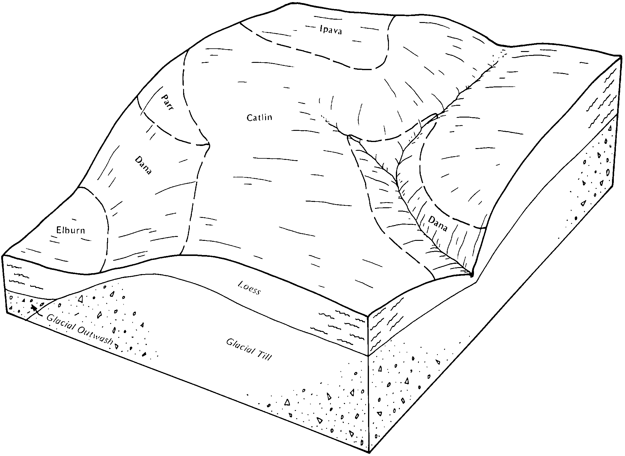
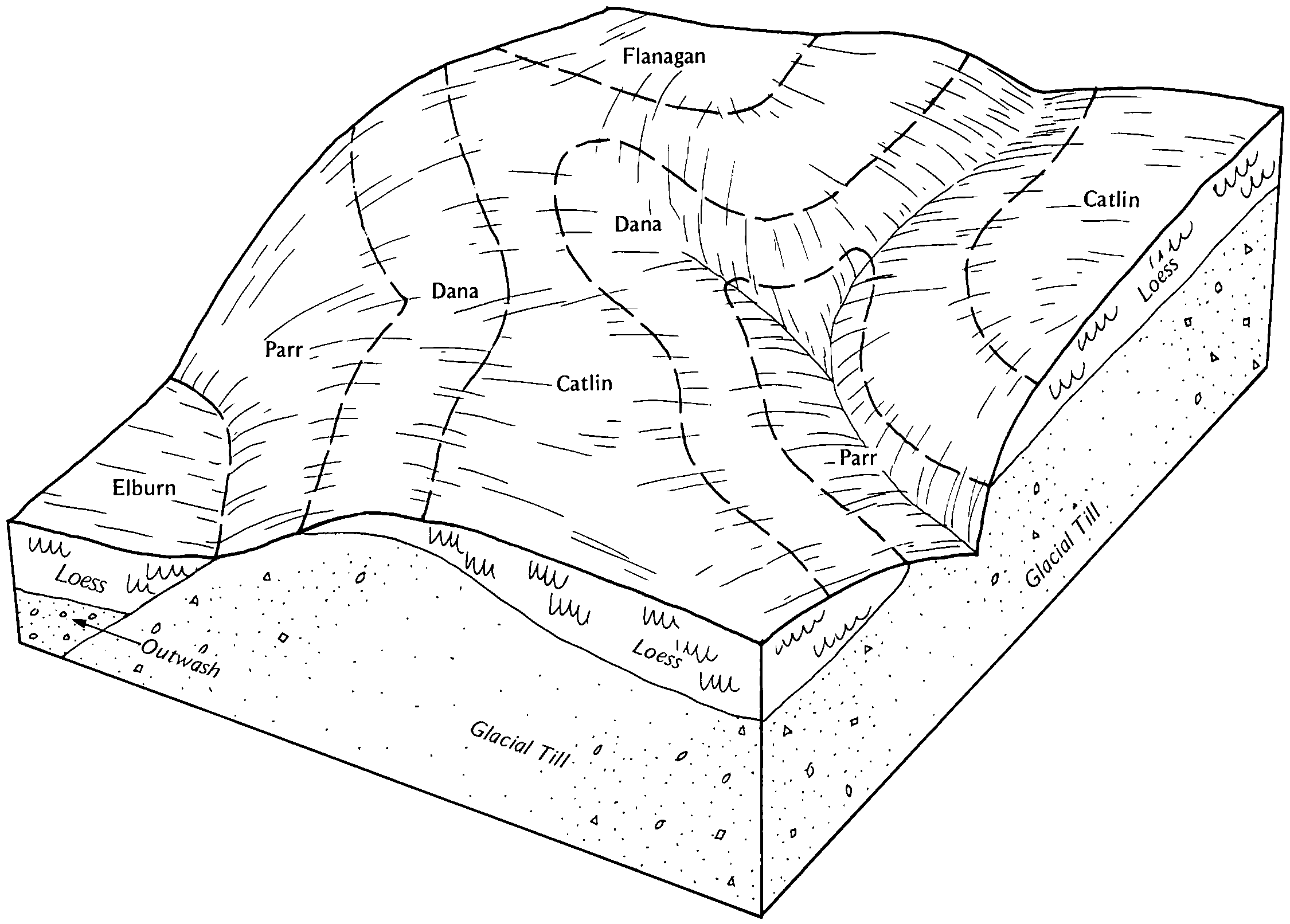
| Dana silt loam, 2 to 5 percent slopes | 56B | 22846 | 242969 | 2smzw | il019 | 1999 | 1:12000 |
Dana silt loam, 2 to 5 percent slopes, eroded | 56B2 | 136 | 242972 | 2smzx | il019 | 1999 | 1:12000 |
Dana silt loam, 2 to 5 percent slopes, eroded | 56B2 | 10234 | 1428382 | 2smzx | il029 | 2005 | 1:12000 |
Dana silt loam, 2 to 5 percent slopes | 56B | 3710 | 1428381 | 2smzw | il029 | 2005 | 1:12000 |
Dana silt loam, 2 to 5 percent slopes, eroded | 56B2 | 2858 | 1529896 | 2smzx | il039 | 2005 | 1:12000 |
Dana silt loam, 2 to 5 percent slopes | 56B | 4049 | 200172 | 2smzw | il041 | 2004 | 1:12000 |
Dana silt loam, 2 to 5 percent slopes | 56B | 16720 | 843533 | 2smzw | il045 | 1997 | 1:12000 |
Dana silt loam, 2 to 5 percent slopes, eroded | 56B2 | 14470 | 843534 | 2smzx | il045 | 1997 | 1:12000 |
Dana silt loam, 2 to 5 percent slopes | 56B | 3372 | 198275 | 2smzw | il053 | 2001 | 1:12000 |
Dana silt loam, 2 to 5 percent slopes, eroded | 56B2 | 182 | 198276 | 2smzx | il053 | 2001 | 1:12000 |
Dana silt loam, 2 to 5 percent slopes, eroded | 56B2 | 3219 | 199055 | 2smzx | il113 | 2000 | 1:12000 |
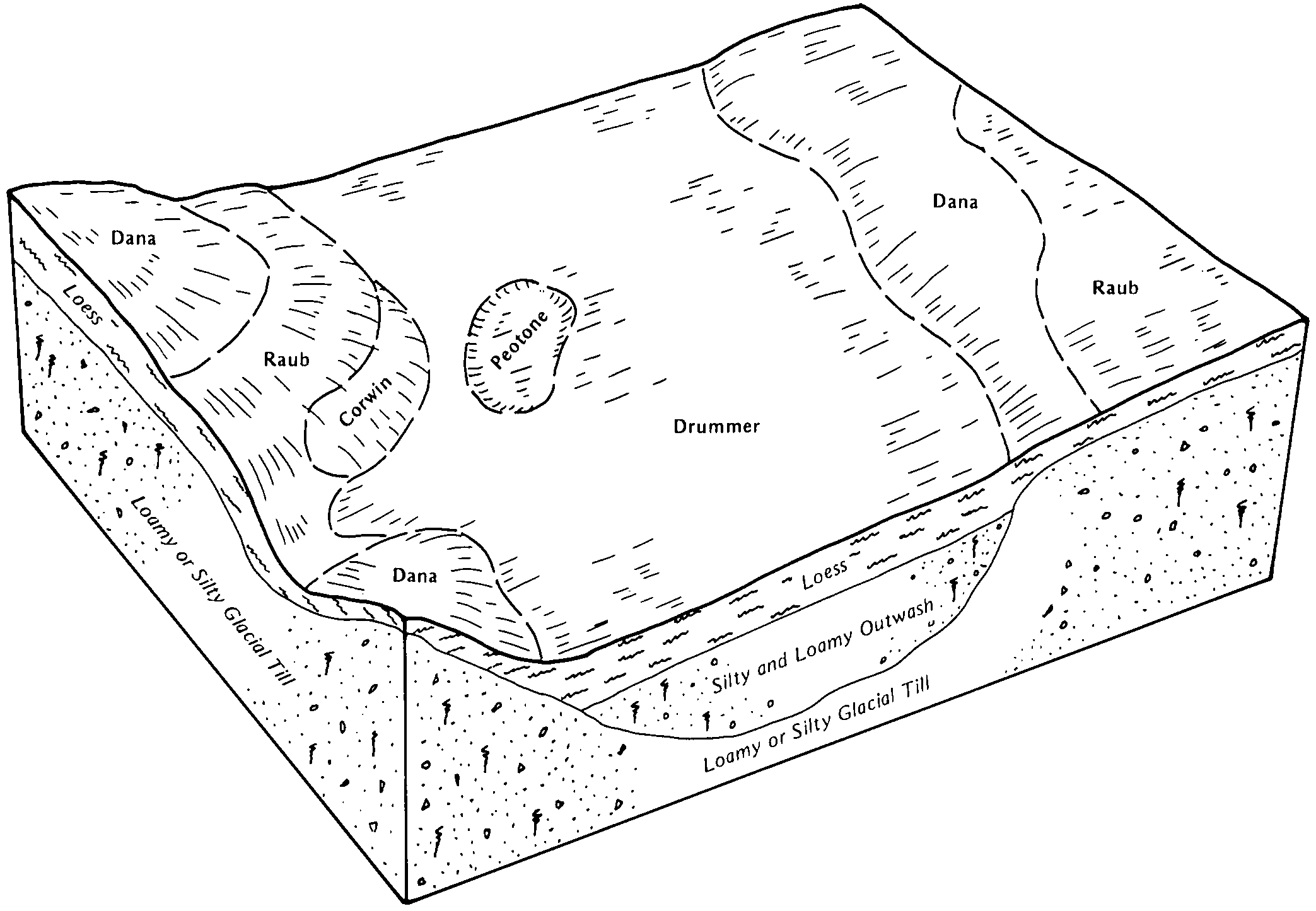
Dana silty clay loam, 5 to 10 percent slopes, eroded | 56C2 | 2439 | 621226 | nvfk | il113 | 2000 | 1:12000 |
Dana silt loam, 2 to 5 percent slopes | 56B | 6283 | 1913923 | 2smzw | il115 | 2007 | 1:12000 |
Dana silty clay loam, 5 to 10 percent slopes, eroded | 56C2 | 2286 | 1913925 | 227lj | il115 | 2007 | 1:12000 |
Dana silt loam, 2 to 5 percent slopes, eroded | 56B2 | 112 | 1913924 | 2smzx | il115 | 2007 | 1:12000 |
Dana silt loam, 0 to 2 percent slopes | 56A | 12170 | 246544 | 2smzv | il139 | 1999 | 1:12000 |
Dana silt loam, 2 to 5 percent slopes, eroded | 56B2 | 9163 | 246545 | 2smzx | il139 | 1999 | 1:12000 |
Dana silt loam, 2 to 5 percent slopes, eroded | 56B2 | 7622 | 1912952 | 2smzx | il147 | 2009 | 1:12000 |
Dana silt loam, 2 to 5 percent slopes | 56B | 2207 | 1913158 | 2smzw | il147 | 2009 | 1:12000 |
Dana silty clay loam, 5 to 10 percent slopes, severely eroded | 56C3 | 1012 | 1949525 | 23fmx | il147 | 2009 | 1:12000 |
Dana silty clay loam, 5 to 10 percent slopes, eroded | 56C2 | 908 | 1722815 | 1vtqp | il147 | 2009 | 1:12000 |
Dana silt loam, 2 to 5 percent slopes, eroded | 56B2 | 17499 | 179032 | 2smzx | il173 | 1990 | 1:15840 |
Dana silt loam, 0 to 2 percent slopes | 56A | 1673 | 179031 | 2smzv | il173 | 1990 | 1:15840 |
Dana silt loam, 2 to 5 percent slopes, eroded | 56B2 | 6887 | 1601008 | 2smzx | il183 | 2006 | 1:12000 |
Dana silt loam, 0 to 2 percent slopes | DaA | 2099 | 162324 | 5fx8 | in023 | 1978 | 1:20000 |
Dana silt loam, 2 to 6 percent slopes | DaB | 323 | 162325 | 5fx9 | in023 | 1978 | 1:20000 |
Dana silt loam, 2 to 5 percent slopes | DaB | 1165 | 160426 | 2smzw | in165 | 1977 | 1:20000 |
Dana silt loam, 2 to 6 percent slopes | DaB | 2999 | 169749 | 2w0v8 | oh017 | 1977 | 1:15840 |
Dana-Urban land complex, 2 to 6 percent slopes | DaUB | 1304 | 3381068 | 30tp5 | oh017 | 1977 | 1:15840 |
Dana silt loam, bedrock substratum, 2 to 8 percent slopes | DbB | 1004 | 169750 | 5pmt | oh017 | 1977 | 1:15840 |
Dana silt loam, 0 to 2 percent slopes | DaA | 704 | 169748 | 5pmr | oh017 | 1977 | 1:15840 |
Urban land-Dana complex, 2 to 6 percent slopes | UDaB | 484 | 3381069 | 30tp6 | oh017 | 1977 | 1:15840 |
Dana-Urban land complex, 0 to 2 percent slopes | DaUA | 282 | 3381066 | 30tp3 | oh017 | 1977 | 1:15840 |
Dana, bedrock substratum-Urban land complex, 2 to 8 percent slopes | DbUB | 128 | 3381070 | 30tp7 | oh017 | 1977 | 1:15840 |
Urban land-Dana complex, 0 to 2 percent slopes | UDaA | 72 | 3381067 | 30tp4 | oh017 | 1977 | 1:15840 |
Urban land-Mollic Udarents-Dana complex, 0 to 12 percent slopes | UMDXC | 117 | 2652905 | 2q6ys | oh061 | 1980 | 1:15840 |
Dana silt loam, 0 to 4 percent slopes | DaB | 54 | 169381 | 5p7x | oh061 | 1980 | 1:15840 |
Dana silt loam, 2 to 6 percent slopes | DcB | 25 | 1720796 | 2w0v8 | oh061 | 1980 | 1:15840 |
Dana silt loam, 2 to 6 percent slopes | DaB | 547 | 1420403 | 2w0v8 | oh071 | 1973 | 1:15840 |
Dana silt loam, 0 to 2 percent slopes | DaA | 318 | 1420402 | 1jp1f | oh071 | 1973 | 1:15840 |
Dana silt loam, 2 to 6 percent slopes | DaB | 850 | 170241 | 2w0v8 | oh113 | 1969 | 1:15840 |
Dana silt loam, 2 to 6 percent slopes | DaB | 314 | 210758 | 2w0v8 | oh135 | 2005 | 1:12000 |
Dana silt loam, 0 to 2 percent slopes | DaA | 297 | 210759 | 729p | oh135 | 2005 | 1:12000 |
Dana silt loam, 2 to 6 percent slopes | DaB | 4719 | 171331 | 2w0v8 | oh165 | 1967 | 1:20000 |
Dana-Urban land complex, 2 to 6 percent slopes | DaUB | 2178 | 3422237 | 30tp5 | oh165 | 1967 | 1:20000 |
Urban land-Dana complex, 2 to 6 percent slopes | UDaB | 409 | 3422238 | 30tp6 | oh165 | 1967 | 1:20000 |
Dana silt loam, 0 to 2 percent slopes | DaA | 137 | 171330 | 5r8s | oh165 | 1967 | 1:20000 |
Urban land-Dana complex, 0 to 2 percent slopes | UDaA | 62 | 3422236 | 30tp4 | oh165 | 1967 | 1:20000 |
Dana-Urban land complex, 0 to 2 percent slopes | DaUA | 48 | 3422235 | 30tp3 | oh165 | 1967 | 1:20000 |


