| Croswell sand, nearly level and undulating | 224B | 2800 | 190272 | 2whw2 | mi001 | 1993 | 1:20000 |
Croswell sand, 0 to 6 percent slopes | CswaaA | 2525 | 2574635 | 2whw1 | mi001 | 1993 | 1:20000 |
Au Gres-Allendale-Croswell sands, nearly level | 253A | 1926 | 190296 | 6d0l | mi001 | 1993 | 1:20000 |
Croswell sand, 0 to 3 percent slopes | 15A | 1652 | 1455250 | 2xtn4 | mi003 | 2007 | 1:24000 |
Croswell-Kinross complex, 0 to 6 percent slopes | 176B | 1382 | 1455339 | 1kvdf | mi003 | 2007 | 1:24000 |
Croswell sand, 0 to 6 percent slopes | CswaaA | 6257 | 2574639 | 2whw1 | mi007 | 1998 | 1:12000 |
Croswell sand, 0 to 6 percent slopes | CswaaA | 1212 | 2574644 | 2whw1 | mi009 | 1976 | 1:15840 |
Croswell-Au Gres sands, 0 to 3 percent slopes | CswauA | 384 | 3155897 | 2ythb | mi009 | 1976 | 1:15840 |
Kinross-Croswell complex, 0 to 3 percent slopes | 32A | 3170 | 414972 | fxt6 | mi013 | 1984 | 1:20000 |
Croswell sand, 0 to 3 percent slopes | 16A | 2338 | 414952 | 2xtn4 | mi013 | 1984 | 1:20000 |
Vilas, very deep water table-Croswell complex, 1 to 6 percent slopes | 8113B | 141 | 2441907 | 2mz06 | mi013 | 1984 | 1:20000 |
Vilas, very deep water table-Croswell-Pence, very deep water table, complex, 1 to 6 percent slopes | 8058B | 66 | 2475139 | 2p2l6 | mi013 | 1984 | 1:20000 |
Croswell sand, 0 to 6 percent slopes | CswaaA | 793 | 2574643 | 2whw1 | mi029 | 1970 | 1:15840 |
Croswell sand, 0 to 6 percent slopes | CswaaA | 11613 | 2574650 | 2whw1 | mi031 | 1988 | 1:15840 |
Croswell sand, 0 to 3 percent slopes | 20A | 12103 | 415130 | 2xtn4 | mi033 | 1989 | 1:15840 |
Croswell-Au Gres sands, 0 to 3 percent slopes | 88A | 10820 | 415178 | fy0v | mi033 | 1989 | 1:15840 |
Croswell-Markey complex, 0 to 6 percent slopes | 125B | 1362 | 415082 | fxxr | mi033 | 1989 | 1:15840 |
Allendale-Croswell complex, 0 to 3 percent slopes | 83A | 568 | 415171 | fy0m | mi033 | 1989 | 1:15840 |
Croswell sand, 0 to 6 percent slopes | CswaaA | 12311 | 2574645 | 2whw1 | mi035 | 1977 | 1:15840 |
Croswell sand, 0 to 6 percent slopes | CswaaA | 14619 | 2574636 | 2whw1 | mi039 | 1993 | 1:15840 |
Croswell-Au Gres sands, 0 to 3 percent slopes | 15A | 4059 | 189659 | 6cc1 | mi039 | 1993 | 1:15840 |
Au Gres-Kinross-Croswell complex, 0 to 6 percent slopes | 50B | 984 | 189722 | 6cf2 | mi039 | 1993 | 1:15840 |
Croswell sand, 0 to 3 percent slopes | CrA | 13855 | 1588036 | 2xtn4 | mi041 | 1969 | 1:24000 |
Croswell sand, 0 to 6 percent slopes | CswaaA | 1068 | 2574634 | 2whw1 | mi047 | 1968 | 1:20000 |
Croswell-Au Gres association | CT | 3905 | 189771 | 6cgn | mi051 | 1966 | 1:15840 |
Rubicon-Croswell association, undulating | RUB | 3744 | 189854 | 6ckb | mi051 | 1966 | 1:15840 |
Croswell-Au Gres-Roscommon association | CW | 3173 | 189773 | 6cgq | mi051 | 1966 | 1:15840 |
Gladwin-Epoufette-Croswell association, undulating | GPB | 2806 | 189783 | 6ch1 | mi051 | 1966 | 1:15840 |
Croswell sand, 0 to 6 percent slopes | CswaaA | 2655 | 2574633 | 2whw1 | mi051 | 1966 | 1:15840 |
Grayling-Croswell-Au Gres association | GU | 663 | 189786 | 6ch4 | mi051 | 1966 | 1:15840 |
Croswell-Au Gres-Kinross association | CU | 513 | 189772 | 6cgp | mi051 | 1966 | 1:15840 |
Vilas, very deep water table-Croswell-Pence, very deep water table, complex, 1 to 6 percent slopes | 58B | 1376 | 1456239 | 1kwbg | mi053 | 2007 | 1:24000 |
Manitowish-Croswell complex, 1 to 6 percent slopes | 53B | 500 | 1456231 | 1kwb6 | mi053 | 2007 | 1:24000 |
Croswell-Rubicon sands, 0 to 2 percent slopes | CrA | 4566 | 189400 | 6c2p | mi055 | 1963 | 1:15840 |
Croswell loamy sands, 0 to 2 percent slopes | CpA | 4006 | 189396 | 6c2k | mi055 | 1963 | 1:15840 |
Croswell-Rubicon sands, 2 to 6 percent slopes | CrB | 1358 | 189402 | 6c2r | mi055 | 1963 | 1:15840 |
Croswell loamy sands, 2 to 6 percent slopes | CpB | 938 | 189398 | 6c2m | mi055 | 1963 | 1:15840 |
Croswell sand, 0 to 6 percent slopes | CswaaA | 601 | 2574631 | 2whw1 | mi055 | 1963 | 1:15840 |
Croswell loamy sands, 0 to 2 percent slopes, overwash | CoA | 563 | 189394 | 6c2h | mi055 | 1963 | 1:15840 |
Croswell loamy sands, 0 to 2 percent slopes, moderately eroded | CpA2 | 233 | 189397 | 6c2l | mi055 | 1963 | 1:15840 |
Croswell-Rubicon sands, 0 to 2 percent slopes, moderately eroded | CrA2 | 203 | 189401 | 6c2q | mi055 | 1963 | 1:15840 |
Croswell loamy sands, 2 to 6 percent slopes, moderately eroded | CpB2 | 125 | 189399 | 6c2n | mi055 | 1963 | 1:15840 |
Croswell loamy sands, 2 to 6 percent slopes, overwash | CoB | 86 | 189395 | 6c2j | mi055 | 1963 | 1:15840 |
Croswell-Au Gres sands, 0 to 3 percent slopes | 75A | 2434 | 416158 | fz1g | mi061 | 1989 | 1:20000 |
Vilas, very deep water table-Croswell complex, 1 to 6 percent slopes | 8113B | 2165 | 2483919 | 2pcqf | mi061 | 1989 | 1:20000 |
Croswell sand, 0 to 3 percent slopes | 17A | 1109 | 416105 | 2xtn4 | mi061 | 1989 | 1:20000 |
Vilas, very deep water table-Croswell-Pence, very deep water table, complex, 1 to 6 percent slopes | 8058B | 315 | 2486060 | 2pfyh | mi061 | 1989 | 1:20000 |
Croswell sand, 0 to 6 percent slopes | CswaaA | 11175 | 2574637 | 2whw1 | mi069 | 1995 | 1:15840 |
Croswell sand, nearly level and undulating | 224B | 4327 | 191767 | 2whw2 | mi069 | 1995 | 1:15840 |
Croswell-Au Gres sands, 0 to 3 percent slopes | 15A | 403 | 191717 | 6fhf | mi069 | 1995 | 1:15840 |
Karlin, moderately wet-Croswell complex, 0 to 3 percent slopes | 69A | 12159 | 416008 | fywm | mi071 | 1992 | 1:20000 |
Vilas, very deep water table-Croswell-Pence, very deep water table, complex, 1 to 6 percent slopes | 8058B | 1295 | 2475138 | 2p2l5 | mi071 | 1992 | 1:20000 |
Manitowish-Croswell complex, 1 to 6 percent slopes | 8053B | 125 | 2474959 | 2p2dd | mi071 | 1992 | 1:20000 |
Croswell sand, 0 to 6 percent slopes | CswaaA | 17426 | 2574641 | 2whw1 | mi079 | 1998 | 1:12000 |
Croswell-Au Gres sands, 0 to 3 percent slopes | 15A | 2940 | 190630 | 6dcc | mi079 | 1998 | 1:12000 |
Au Gres-Kinross-Croswell complex, 0 to 6 percent slopes | 50B | 919 | 190662 | 6ddd | mi079 | 1998 | 1:12000 |
Croswell-Spot complex, 0 to 6 percent slopes | 174B | 3558 | 631319 | p5y4 | mi095 | 2004 | 1:24000 |
Croswell, rarely flooded-Deford, frequently flooded complex, 0 to 6 percent slopes | 201B | 1728 | 631370 | p5zs | mi095 | 2004 | 1:24000 |
Croswell sand, 0 to 3 percent slopes | 20B | 766 | 399620 | 2xtn4 | mi095 | 2004 | 1:24000 |
Croswell-Au Gres sands, 0 to 6 percent slopes | 88B | 717 | 653852 | pyd0 | mi095 | 2004 | 1:24000 |
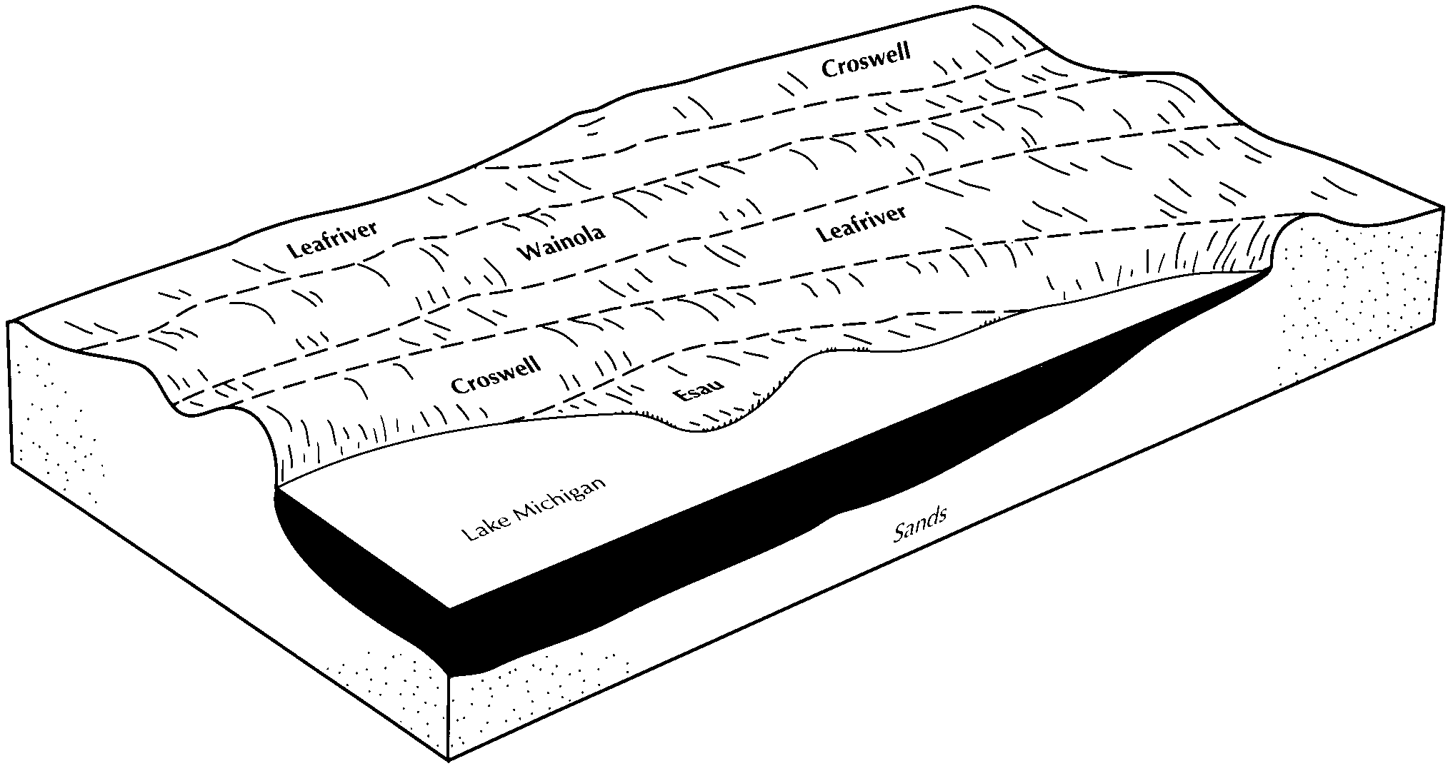
Leafriver-Croswell-Wainola complex, 0 to 6 percent slopes | 172B | 15854 | 416349 | fz7m | mi097 | 1994 | 1:20000 |
Croswell sand, 0 to 3 percent slopes | 20B | 3178 | 416376 | 2xtn4 | mi097 | 1994 | 1:20000 |
Croswell-Wainola complex, 0 to 6 percent slopes | 88B | 1752 | 416430 | fzb7 | mi097 | 1994 | 1:20000 |
Croswell-Spot complex, 0 to 6 percent slopes | 174B | 1110 | 416351 | fz7p | mi097 | 1994 | 1:20000 |
Croswell-Markey complex, 0 to 6 percent slopes | 125B | 433 | 416319 | fz6n | mi097 | 1994 | 1:20000 |
Croswell sand, 0 to 3 percent slopes | 15A | 13491 | 395105 | 2xtn4 | mi103 | 1999 | 1:24000 |
Croswell-Deford complex, 0 to 3 percent slopes | 118A | 9344 | 394998 | f80w | mi103 | 1999 | 1:24000 |
Greenwood-Croswell complex, 0 to 6 percent slopes | 176B | 4570 | 395129 | f853 | mi103 | 1999 | 1:24000 |
Croswell sand, 0 to 6 percent slopes | CswaaA | 11622 | 2574647 | 2whw1 | mi113 | 1983 | 1:15840 |
Croswell and Melita loamy sands, 0 to 2 percent slopes | Cd | 858 | 187275 | 68w4 | mi117 | 1956 | 1:20000 |
Croswell and Melita loamy sands, 2 to 6 percent slopes | Ce | 664 | 187276 | 68w5 | mi117 | 1956 | 1:20000 |
Croswell and Melita loamy sands, 6 to 15 percent slopes | Cg | 99 | 187277 | 68w6 | mi117 | 1956 | 1:20000 |
Croswell sand, 0 to 6 percent slopes | CswaaA | 8374 | 2574638 | 2whw1 | mi119 | 1997 | 1:12000 |
Deford-Au Gres-Croswell complex, 0 to 6 percent slopes | 352B | 5519 | 192248 | 6g1k | mi119 | 1997 | 1:12000 |
Croswell sand, 0 to 6 percent slopes | CswaaA | 14452 | 2574649 | 2whw1 | mi129 | 1987 | 1:15840 |
Croswell sand, loamy substratum, 0 to 3 percent slopes | 44B | 3510 | 189918 | 6cmd | mi129 | 1987 | 1:15840 |
Croswell-Au Gres-Tawas complex, 0 to 18 percent slopes | 120D | 2251 | 1456543 | 1kwn8 | mi131 | 2007 | 1:24000 |
Vilas, very deep water table-Croswell-Pence, very deep water table, complex, 1 to 6 percent slopes | 8058B | 753 | 1674795 | 1t6rn | mi131 | 2007 | 1:24000 |
Vilas, very deep water table-Croswell complex, 1 to 6 percent slopes | 8113B | 430 | 1674829 | 1t6sr | mi131 | 2007 | 1:24000 |
Manitowish-Croswell complex, 1 to 6 percent slopes | 8053B | 319 | 1674793 | 1t6rl | mi131 | 2007 | 1:24000 |
Croswell sand, 0 to 3 percent slopes | 29A | 226 | 1456408 | 2xtn4 | mi131 | 2007 | 1:24000 |
Croswell sand, 0 to 6 percent slopes | CswaaA | 5685 | 2574632 | 2whw1 | mi133 | 1966 | 1:15840 |
Deford-Au Gres-Croswell complex, 0 to 6 percent slopes | 352B | 7632 | 241413 | 836j | mi135 | 2003 | 1:12000 |
Croswell sand, 0 to 6 percent slopes | CswaaA | 6072 | 2574630 | 2whw1 | mi135 | 2003 | 1:12000 |
Croswell-Au Gres sands, 0 to 3 percent slopes | 15A | 1429 | 241378 | 835d | mi135 | 2003 | 1:12000 |
Au Gres-Kinross-Croswell complex, 0 to 6 percent slopes | 50B | 5 | 241390 | 835s | mi135 | 2003 | 1:12000 |
Croswell sand, 0 to 6 percent slopes | CswaaA | 4443 | 2574640 | 2whw1 | mi137 | 1998 | 1:12000 |
Croswell-Au Gres sands, 0 to 3 percent slopes | 15A | 1776 | 191452 | 6f6w | mi137 | 1998 | 1:12000 |
Deford-Au Gres-Croswell complex, 0 to 6 percent slopes | 352B | 591 | 191483 | 6f7w | mi137 | 1998 | 1:12000 |
Au Gres-Kinross-Croswell complex, 0 to 6 percent slopes | 50B | 190 | 191504 | 6f8k | mi137 | 1998 | 1:12000 |
Croswell sand, 0 to 6 percent slopes | CrB | 5662 | 192656 | 6ggq | mi139 | 1967 | 1:15840 |
Croswell sand, 0 to 6 percent slopes | CswaaA | 8227 | 2574651 | 2whw1 | mi141 | 1989 | 1:15840 |
Croswell loamy sand, loamy substratum, 0 to 4 percent slopes | 45B | 3773 | 190897 | 6dmz | mi141 | 1989 | 1:15840 |
Deer Park-Croswell-Au Gres complex, 0 to 12 percent slopes | 56C | 3467 | 190914 | 6dnj | mi141 | 1989 | 1:15840 |
Croswell cobbly sand, 0 to 4 percent slopes | 81B | 1453 | 190951 | 2whw3 | mi141 | 1989 | 1:15840 |
Croswell sand, 0 to 6 percent slopes | CswaaA | 22606 | 2574642 | 2whw1 | mi143 | 1999 | 1:12000 |
Au Gres-Kinross-Croswell complex, 0 to 6 percent slopes | 50B | 14740 | 191003 | 6drd | mi143 | 1999 | 1:12000 |
Croswell-Au Gres sands, 0 to 3 percent slopes | 15A | 9905 | 190994 | 6dr3 | mi143 | 1999 | 1:12000 |
Croswell-Kinross complex, 0 to 6 percent slopes | 562B | 881 | 1538080 | 1nmhh | mi153 | 2007 | 1:24000 |
Croswell sand, 0 to 3 percent slopes | 561A | 461 | 1538074 | 2xtn4 | mi153 | 2007 | 1:24000 |
Croswell sand, 0 to 6 percent slopes | CswaaA | 29350 | 2574648 | 2whw1 | mi600 | 1983 | 1:15840 |
Au Gres-Deford-Croswell complex, 0 to 6 percent slopes | 126B | 3486 | 800765 | vw84 | mi605 | 2004 | 1:24000 |
Croswell-Au Gres complex, 0 to 3 percent slopes | 125A | 1320 | 800767 | vw86 | mi605 | 2004 | 1:24000 |
Dawson-Croswell complex, 0 to 8 percent slopes | 15B | 1240 | 800735 | vw75 | mi605 | 2004 | 1:24000 |
Rubicon-Croswell complex, 1 to 12 percent slopes | 113C | 1043 | 800749 | vw7m | mi605 | 2004 | 1:24000 |
Deer Park-Croswell complex, 1 to 12 percent slopes | 112C | 443 | 800748 | vw7l | mi605 | 2004 | 1:24000 |
Shelldrake-Croswell complex, 0 to 8 percent slopes | 110B | 147 | 800745 | vw7h | mi605 | 2004 | 1:24000 |
Cublake-Croswell-Ashwabay complex, 0 to 6 percent slopes | 6705B | 4720 | 1444477 | 1kh31 | wi003 | 2006 | 1:12000 |
Croswell-Chinwhisker complex, 0 to 3 percent slopes | 3591A | 1470 | 1444453 | 1kh28 | wi003 | 2006 | 1:12000 |
Cublake-Croswell-Ashwabay complex, 6 to 15 percent slopes | 6705C | 1034 | 1444478 | 1kh32 | wi003 | 2006 | 1:12000 |
Croswell sand, 0 to 6 percent slopes | 6500B | 483 | 1444431 | 1kh1k | wi003 | 2006 | 1:12000 |
Cublake-Croswell-Ashwabay complex, 0 to 6 percent slopes | 6705B | 19726 | 433296 | gjw9 | wi007 | 2005 | 1:12000 |
Cublake-Croswell-Ashwabay complex, 6 to 15 percent slopes | 6705C | 9731 | 433299 | gjwd | wi007 | 2005 | 1:12000 |
Croswell sand, 0 to 6 percent slopes | 6500B | 2284 | 433582 | gk5j | wi007 | 2005 | 1:12000 |
Croswell-Chinwhisker complex, 0 to 3 percent slopes | 3591A | 1676 | 1147409 | 17hz6 | wi007 | 2005 | 1:12000 |
Croswell loamy sand, 0 to 3 percent slopes | 3371A | 826 | 782467 | 2xtn5 | wi007 | 2005 | 1:12000 |
Croswell sand, 0 to 3 percent slopes | 3500A | 445 | 782475 | 2xtn4 | wi007 | 2005 | 1:12000 |
Croswell loamy sand, 0 to 3 percent slopes | 3371A | 4055 | 781200 | 2xtn5 | wi031 | 2005 | 1:12000 |
Cublake-Croswell-Ashwabay complex, 0 to 6 percent slopes | 6705B | 1472 | 1487650 | 1ly0q | wi031 | 2005 | 1:12000 |
Croswell sand, 0 to 3 percent slopes | 3500A | 1105 | 781296 | 2xtn4 | wi031 | 2005 | 1:12000 |
Croswell sand, 0 to 6 percent slopes | 6500B | 267 | 781297 | v704 | wi031 | 2005 | 1:12000 |
Croswell-Chinwhisker complex, 0 to 3 percent slopes | 3591A | 202 | 1149640 | 17l95 | wi031 | 2005 | 1:12000 |
Croswell loamy sand, 0 to 3 percent slopes | 3371A | 1666 | 429995 | 2xtn5 | wi037 | 1995 | 1:12000 |
Croswell sand, 0 to 4 percent slopes | 3500B | 1095 | 429834 | 2tnxv | wi041 | 1995 | 1:12000 |
Croswell-Chinwhisker complex, 0 to 3 percent slopes | 3591A | 4033 | 1701242 | 1v38s | wi051 | 2006 | 1:12000 |
Croswell sand, 0 to 4 percent slopes | 3500B | 2147 | 782164 | 2tnxv | wi051 | 2006 | 1:12000 |
Cublake-Croswell-Ashwabay complex, 0 to 6 percent slopes | 6705B | 1846 | 1697708 | 1tzls | wi051 | 2006 | 1:12000 |
Cublake-Croswell-Ashwabay complex, 6 to 15 percent slopes | 6705C | 1305 | 1697709 | 1tzlt | wi051 | 2006 | 1:12000 |
Croswell loamy sand, 0 to 3 percent slopes | 3371A | 1519 | 421048 | 2xtn5 | wi067 | 1983 | 1:20000 |
Croswell sand, 0 to 4 percent slopes | 3500B | 8196 | 431612 | 2tnxv | wi069 | 1993 | 1:20000 |
Croswell loamy sand, 0 to 3 percent slopes | 3371A | 18661 | 422383 | 2xtn5 | wi075 | 1987 | 1:20000 |
Croswell loamy sand, 0 to 3 percent slopes | 3371A | 1618 | 395788 | 2xtn5 | wi078 | 1998 | 1:12000 |
Croswell sand, 0 to 4 percent slopes | 3500B | 18833 | 421081 | 2tnxv | wi085 | 1988 | 1:20000 |
Croswell loamy sand, 0 to 3 percent slopes | 3371A | 839 | 421170 | 2xtn5 | wi095 | 1978 | 1:15840 |
Croswell-Chinwhisker complex, 0 to 3 percent slopes | 3591A | 4501 | 1292270 | 1dcq4 | wi099 | 2006 | 1:12000 |
Croswell-Chinwhisker complex, 0 to 3 percent slopes | 3591A | 15 | 1145157 | 17fmk | wi107 | 2006 | 1:12000 |
Croswell-Chinwhisker complex, 0 to 3 percent slopes | 3591A | 4881 | 1017815 | 1353r | wi113 | 2006 | 1:12000 |
Croswell loamy sand, 0 to 3 percent slopes | 3371A | 8021 | 422664 | 2xtn5 | wi115 | 1981 | 1:15840 |
Croswell sand, 0 to 4 percent slopes | 3500B | 20589 | 421232 | 2tnxv | wi125 | 1985 | 1:20000 |
Croswell loamy sand, 0 to 3 percent slopes | 3371A | 465 | 435500 | 2xtn5 | wi129 | 2002 | 1:12000 |