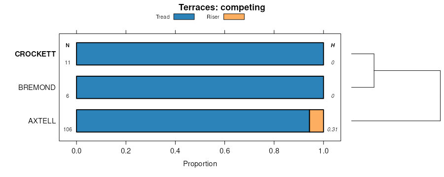
| Crockett-Durant complex, 1 to 5 percent slopes, eroded | 21 | 24491 | 381801 | dt95 | ok013 | 1974 | 1:24000 |
Crockett loam, 1 to 3 percent slopes | 20 | 1818 | 381800 | 2ssh6 | ok013 | 1974 | 1:24000 |
Crockett loam, 1 to 5 percent slopes, severely eroded | 22 | 795 | 381802 | dt96 | ok013 | 1974 | 1:24000 |
Crockett fine sandy loam, 2 to 5 percent slopes, eroded | CsC2 | 45004 | 393283 | 2ssh9 | tx021 | 1972 | 1:24000 |
Crockett fine sandy loam, 1 to 3 percent slopes | CfB | 16153 | 393279 | 2ssh8 | tx021 | 1972 | 1:24000 |
Crockett fine sandy loam, 3 to 8 percent slopes, severely eroded | CsD3 | 10860 | 393284 | 2t0rz | tx021 | 1972 | 1:24000 |
Crockett fine sandy loam, 5 to 10 percent slopes | CsE2 | 5244 | 393285 | 2t0ry | tx021 | 1972 | 1:24000 |
Crockett gravelly fine sandy loam, 1 to 5 percent slopes | CgC | 4647 | 393280 | 2sshb | tx021 | 1972 | 1:24000 |
Crockett gravelly loam, 5 to 10 percent slopes | ChE | 1015 | 393281 | f67h | tx021 | 1972 | 1:24000 |
Crockett loam, 1 to 3 percent slopes | CrB | 10966 | 363188 | 2vth8 | tx041 | 1993 | 1:20000 |
Crockett loam, 2 to 5 percent slopes, eroded | CrB2 | 2025 | 363189 | d5xs | tx041 | 1993 | 1:20000 |
Crockett loam, 1 to 3 percent slopes | CrB | 8860 | 363440 | 2vth8 | tx051 | 1994 | 1:24000 |
Crockett soils, 2 to 5 percent slopes, eroded | CrC2 | 28015 | 363504 | 2vthb | tx055 | 1972 | 1:20000 |
Crockett fine sandy loam, 1 to 3 percent slopes | CfB | 25779 | 363502 | 2ssh8 | tx055 | 1972 | 1:20000 |
Crockett gravelly fine sandy loam, 1 to 5 percent slopes | CgC | 11357 | 363503 | 2sshb | tx055 | 1972 | 1:20000 |
Crockett soils, 3 to 8 percent slopes, severely eroded | CrD3 | 4445 | 363505 | d67z | tx055 | 1972 | 1:20000 |
Crockett soils, 2 to 5 percent slopes, eroded | CrC2 | 2942 | 364062 | 2vthb | tx085 | 1965 | 1:20000 |
Crockett soils, 5 to 8 percent slopes, eroded | CrD2 | 155 | 364063 | 2wg94 | tx085 | 1965 | 1:20000 |
Crockett fine sandy loam, 1 to 5 percent slopes, eroded | 16 | 13344 | 364463 | d77w | tx097 | 1973 | 1:24000 |
Crockett fine sandy loam, 1 to 3 percent slopes | 15 | 3926 | 364462 | d77v | tx097 | 1973 | 1:24000 |
Normangee and Crockett soils, 3 to 8 percent slopes, severely eroded | 58 | 1749 | 364509 | d79c | tx097 | 1973 | 1:24000 |
Crockett fine sandy loam, 0 to 1 percent slopes | 14 | 629 | 364461 | d77t | tx097 | 1973 | 1:24000 |
Crockett fine sandy loam, 1 to 3 percent slopes | 21 | 1259 | 364802 | 2ssh8 | tx113 | 1975 | 1:20000 |
Crockett fine sandy loam, 0 to 1 percent slopes | 20 | 1012 | 364801 | 2vth9 | tx113 | 1975 | 1:20000 |
Crockett fine sandy loam, 2 to 5 percent slopes, eroded | 22 | 651 | 364803 | 2ssh9 | tx113 | 1975 | 1:20000 |
Crockett fine sandy loam, 1 to 3 percent slopes | 27 | 3877 | 364977 | d7sg | tx121 | 1975 | 1:24000 |
Crockett-Urban land complex, 0 to 2 percent slopes | 28 | 1703 | 364978 | d7sh | tx121 | 1975 | 1:24000 |
Crockett fine sandy loam, 0 to 1 percent slopes | 26 | 1559 | 364976 | d7sf | tx121 | 1975 | 1:24000 |
Crockett fine sandy loam, 1 to 3 percent slopes | CrB | 10804 | 365049 | d7vs | tx123 | 1973 | 1:20000 |
Crockett soils, 2 to 5 percent slopes, eroded | CsC2 | 5435 | 365051 | d7vv | tx123 | 1973 | 1:20000 |
Crockett fine sandy loam, 3 to 5 percent slopes | CrC | 3605 | 365050 | d7vt | tx123 | 1973 | 1:20000 |
Crockett fine sandy loam, 0 to 1 percent slopes | CrA | 1643 | 365048 | d7vr | tx123 | 1973 | 1:20000 |
Crockett soils, 2 to 5 percent slopes, eroded | CrC2 | 6404 | 365288 | 2vthb | tx139 | 1962 | 1:20000 |
Crockett fine sandy loam, 3 to 8 percent slopes, severely eroded | CrD3 | 722 | 365289 | 2t0rz | tx139 | 1962 | 1:20000 |
Crockett fine sandy loam, 1 to 3 percent slopes | 20 | 22288 | 365438 | 2ssh8 | tx145 | 1975 | 1:20000 |
Crockett fine sandy loam, 2 to 5 percent slopes, eroded | 21 | 12965 | 365439 | 2ssh9 | tx145 | 1975 | 1:20000 |
Crockett fine sandy loam, 0 to 1 percent slopes | 19 | 9584 | 365436 | 2vth9 | tx145 | 1975 | 1:20000 |
Axtell and Crockett soils, 2 to 8 percent slopes, severely eroded | 10 | 1620 | 365427 | d87z | tx145 | 1975 | 1:20000 |
Crockett loam, 1 to 3 percent slopes | CrB | 17510 | 365506 | 2ssh4 | tx147 | 1989 | 1:24000 |
Crockett loam, 2 to 5 percent slopes, eroded | CrC2 | 4364 | 365507 | d8bk | tx147 | 1989 | 1:24000 |
Crockett loam, 1 to 3 percent slopes | CrB | 7321 | 365703 | 2vth8 | tx149 | 1991 | 1:24000 |
Crockett fine sandy loam, 1 to 3 percent slopes | CrB | 20737 | 375375 | 2ssh8 | tx161 | 1986 | 1:24000 |
Crockett fine sandy loam, 2 to 5 percent slopes, eroded | CrC3 | 4483 | 375377 | 2ssh9 | tx161 | 1986 | 1:24000 |
Crockett fine sandy loam, 0 to 1 percent slopes | CrA | 4148 | 375374 | 2vth9 | tx161 | 1986 | 1:24000 |
Crockett fine sandy loam, 3 to 5 percent slopes | CrC | 3094 | 375376 | 2t0rx | tx161 | 1986 | 1:24000 |
Crockett fine sandy loam, 3 to 8 percent slopes, severely eroded | CrD4 | 2704 | 375379 | 2t0rz | tx161 | 1986 | 1:24000 |
Crockett fine sandy loam, 5 to 10 percent slopes | CrD | 431 | 375378 | 2t0ry | tx161 | 1986 | 1:24000 |
Crockett fine sandy loam, 1 to 3 percent slopes | CrB | 16352 | 366507 | 2ssh8 | tx177 | 1997 | 1:24000 |
Crockett fine sandy loam, 2 to 5 percent slopes, eroded | CrC2 | 8497 | 366508 | 2ssh9 | tx177 | 1997 | 1:24000 |
Crockett gravelly fine sandy loam, 2 to 5 percent slopes, eroded | CsC2 | 1489 | 366549 | d9f5 | tx177 | 1997 | 1:24000 |
Crockett gravelly fine sandy loam, 1 to 3 percent slopes | CsB | 1407 | 366548 | d9f4 | tx177 | 1997 | 1:24000 |
Crockett loam, 2 to 5 percent slopes, eroded | 23 | 24855 | 366658 | 2ssh7 | tx181 | 1977 | 1:20000 |
Crockett loam, 1 to 3 percent slopes | 22 | 20197 | 366657 | 2ssh6 | tx181 | 1977 | 1:20000 |
Crockett loam, 0 to 1 percent slopes | 21 | 4706 | 366656 | 2t0s0 | tx181 | 1977 | 1:20000 |
Crockett-Urban land complex, 0 to 3 percent slopes | 24 | 1277 | 366659 | d9jq | tx181 | 1977 | 1:20000 |
Crockett fine sandy loam, 1 to 5 percent slopes | CrC | 4811 | 366753 | d9mr | tx185 | 1988 | 1:24000 |
Crockett fine sandy loam, 5 to 8 percent slopes | CrD | 867 | 366755 | d9mt | tx185 | 1988 | 1:24000 |
Crockett fine sandy loam, 1 to 5 percent slopes, eroded | CrC2 | 221 | 366754 | d9ms | tx185 | 1988 | 1:24000 |
Crockett loam, 2 to 5 percent slopes, eroded | CsC3 | 32615 | 366848 | 2ssh7 | tx187 | 1973 | 1:20000 |
Crockett fine sandy loam, 1 to 3 percent slopes | CfB | 18910 | 366846 | 2ssh8 | tx187 | 1973 | 1:20000 |
Crockett gravelly fine sandy loam, 1 to 5 percent slopes | CgC | 7467 | 366847 | 2sshb | tx187 | 1973 | 1:20000 |
Crockett loam, 3 to 8 percent slopes, severely eroded | CsD4 | 3680 | 366849 | d9qv | tx187 | 1973 | 1:20000 |
Crockett fine sandy loam, 0 to 1 percent slopes | CfA | 1206 | 366845 | 2vth9 | tx187 | 1973 | 1:20000 |
Crockett loam, 1 to 3 percent slopes | 6 | 3730 | 367640 | 2ssh4 | tx213 | 1978 | 1:20000 |
Crockett fine sandy loam, 1 to 3 percent slopes | 29 | 12657 | 367741 | 2ssh8 | tx217 | 1975 | 1:20000 |
Crockett-Wilson complex, 0 to 2 percent slopes | 30 | 2699 | 367743 | dbnp | tx217 | 1975 | 1:20000 |
Crockett fine sandy loam, 0 to 1 percent slopes | 28 | 1561 | 367740 | 2vth9 | tx217 | 1975 | 1:20000 |
Crockett loam, 1 to 3 percent slopes | 6 | 85554 | 367898 | 2ssh4 | tx231 | 1978 | 1:24000 |
Crockett loam, 2 to 5 percent slopes, eroded | 7 | 34641 | 367899 | dbtq | tx231 | 1978 | 1:24000 |
Crockett-Urban land complex, 1 to 3 percent slopes | 8 | 3166 | 367900 | dbtr | tx231 | 1978 | 1:24000 |
Crockett fine sandy loam, 1 to 5 percent slopes | CrC | 10950 | 369081 | dd1v | tx287 | 2002 | 1:24000 |
Crockett fine sandy loam, 2 to 5 percent slopes, eroded | CrC2 | 2046 | 748067 | 2ssh9 | tx287 | 2002 | 1:24000 |
Crockett gravelly fine sandy loam, 1 to 5 percent slope | CgB | 1472 | 748086 | t3ft | tx287 | 2002 | 1:24000 |
Crockett-Wilson complex, 1 to 3 percent slopes | CsB | 11642 | 369181 | dd52 | tx289 | 1985 | 1:24000 |
Crockett fine sandy loam, 1 to 5 percent slopes | CrB | 9571 | 369179 | dd50 | tx289 | 1985 | 1:24000 |
Crockett fine sandy loam, 5 to 10 percent slopes | CrD | 2543 | 369180 | dd51 | tx289 | 1985 | 1:24000 |
Crockett loam, 1 to 3 percent slopes | CrB | 51454 | 369387 | 2ssh6 | tx293 | 1991 | 1:24000 |
Crockett loam, 2 to 5 percent slopes, eroded | CrC2 | 34120 | 369388 | 2ssh7 | tx293 | 1991 | 1:24000 |
Crockett loam, 0 to 1 percent slopes | CrA | 4001 | 369386 | 2t0s0 | tx293 | 1991 | 1:24000 |
Crockett loam, 3 to 5 percent slopes | CrB | 2909 | 370085 | 2vv4y | tx309 | 1992 | 1:24000 |
Crockett loam, 1 to 3 percent slopes | CrB | 2868 | 370275 | 2vth8 | tx313 | 1989 | 1:24000 |
Crockett fine sandy loam, 1 to 3 percent slopes | CrB | 21733 | 370666 | 2ssh8 | tx331 | 1988 | 1:24000 |
Crockett fine sandy loam, 2 to 5 percent slopes, eroded | CrC3 | 4998 | 370667 | 2ssh9 | tx331 | 1988 | 1:24000 |
Crockett fine sandy loam, 1 to 3 percent slopes | KlB | 4579 | 575592 | m9yh | tx339 | 1967 | 1:20000 |
Crockett fine sandy loam, 1 to 3 percent slopes | CrB | 72848 | 370922 | 2ssh8 | tx349 | 1968 | 1:24000 |
Crockett fine sandy loam, 0 to 1 percent slopes | CrA | 36410 | 370921 | 2vth9 | tx349 | 1968 | 1:24000 |
Crockett soils, 2 to 5 percent slopes, eroded | CtC2 | 21834 | 370925 | 2vthb | tx349 | 1968 | 1:24000 |
Crockett fine sandy loam, 3 to 5 percent slopes | CrC | 11635 | 370923 | 2t0rx | tx349 | 1968 | 1:24000 |
Crockett fine sandy loam, 3 to 8 percent slopes, severely eroded | CtD3 | 7826 | 370926 | 2t0rz | tx349 | 1968 | 1:24000 |
Crockett fine sandy loam, 5 to 10 percent slopes | CrD | 4705 | 370924 | 2t0ry | tx349 | 1968 | 1:24000 |
Crockett loam, 1 to 3 percent slopes | CrB | 5040 | 371432 | 2ssh4 | tx387 | 1972 | 1:24000 |
Crockett loam, 1 to 3 percent slopes | CrB | 9603 | 371702 | 2ssh6 | tx395 | 1996 | 1:24000 |
Crockett loam, 2 to 5 percent slopes, eroded | CrC2 | 6035 | 371703 | 2ssh7 | tx395 | 1996 | 1:24000 |
Crockett soils, 2 to 5 percent slopes, eroded | CsC2 | 1122 | 392235 | 2vthb | tx453 | 1969 | 1:20000 |
Crockett loam, 1 to 3 percent slopes | CrB | 48441 | 373036 | 2ssh4 | tx467 | 1994 | 1:24000 |
Crockett loam, 2 to 5 percent slopes, eroded | CrC2 | 17882 | 373038 | dj5h | tx467 | 1994 | 1:24000 |
Crockett loam, 0 to 1 percent slopes | CrA | 2452 | 373035 | dj5d | tx467 | 1994 | 1:24000 |
Crockett loam, 3 to 5 percent slopes | CrC | 704 | 373037 | dj5g | tx467 | 1994 | 1:24000 |
Crockett fine sandy loam, 1 to 5 percent slopes | 25 | 15353 | 373152 | dj95 | tx477 | 1979 | 1:24000 |
Crockett fine sandy loam, 5 to 10 percent slopes, eroded | 26 | 1867 | 373153 | dj96 | tx477 | 1979 | 1:24000 |
Crockett loam, 2 to 5 percent slopes, eroded | CrC3 | 5469 | 373536 | 2ssh7 | tx491 | 1981 | 1:20000 |
Crockett loam, 1 to 3 percent slopes | CrB | 2083 | 373535 | 2ssh6 | tx491 | 1981 | 1:20000 |
Crockett fine sandy loam, 1 to 3 percent slopes | CrB | 6586 | 373594 | djrf | tx493 | 1972 | 1:24000 |
Crockett fine sandy loam, 2 to 5 percent slopes eroded | CrC2 | 3204 | 373595 | djrg | tx493 | 1972 | 1:24000 |
Crockett fine sandy loam, 0 to 1 percent slopes | CrA | 1397 | 373593 | djrd | tx493 | 1972 | 1:24000 |
Crockett fine sandy loam, 1 to 5 percent slopes | CrC | 12480 | 373829 | dk00 | tx600 | 1981 | 1:24000 |
Crockett fine sandy loam, 5 to 8 percent slopes | CrD | 3921 | 373831 | dk02 | tx600 | 1981 | 1:24000 |
Crockett fine sandy loam, 2 to 5 percent slopes, eroded | CrC2 | 586 | 373830 | dk01 | tx600 | 1981 | 1:24000 |
Crockett silt loam, 1 to 3 percent slopes | CrB | 14113 | 576089 | mbgj | tx603 | 1984 | 1:24000 |
Crockett silt loam, 2 to 5 percent slopes, severely eroded | CrC3 | 7314 | 576090 | mbgk | tx603 | 1984 | 1:24000 |
Crockett silt loam, 0 to 1 percent slopes | CrA | 5313 | 576088 | mbgh | tx603 | 1984 | 1:24000 |
Crockett loam, 1 to 3 percent slopes | CrB | 117845 | 374386 | 2ssh4 | tx610 | 1973 | 1:20000 |
Crockett loam, 2 to 5 percent slopes, eroded | CrC2 | 49664 | 374388 | dkl1 | tx610 | 1973 | 1:20000 |
Crockett loam, 0 to 1 percent slopes | CrA | 9576 | 374385 | dkky | tx610 | 1973 | 1:20000 |
Crockett loam, 3 to 5 percent slopes | CrC | 3616 | 374387 | dkl0 | tx610 | 1973 | 1:20000 |
Crockett fine sandy loam, 1 to 3 percent slopes | CrB | 31246 | 374467 | 2ssh8 | tx612 | 1973 | 1:20000 |
Crockett fine sandy loam, 2 to 5 percent slopes, eroded | CrC2 | 30783 | 374468 | 2ssh9 | tx612 | 1973 | 1:20000 |
Crockett loam, 1 to 3 percent slopes | 10 | 35552 | 393340 | 2ssh4 | tx614 | 1975 | 1:20000 |
Mabank-Crockett complex, 0 to 1 percent slopes | 34 | 10840 | 393364 | f6b5 | tx614 | 1975 | 1:20000 |