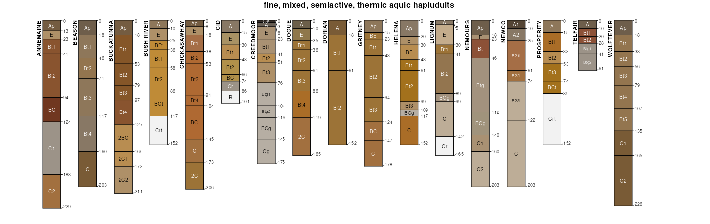
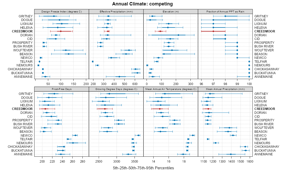
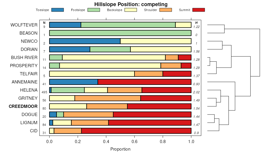
| Creedmoor fine sandy loam, 2 to 8 percent slopes | CrB | 14049 | 114509 | 3v4v | nc007 | 1999 | 1:24000 |
Creedmoor-Green Level complex, 2 to 6 percent slopes | CrB | 20119 | 1485534 | 1lvtg | nc037 | 2005 | 1:24000 |
Creedmoor-Green Level complex, 6 to 10 percent slopes | CrC | 14571 | 1485536 | 1lvtj | nc037 | 2005 | 1:24000 |
Creedmoor-Green Level complex, 10 to 15 percent slopes | CrD | 4884 | 1485532 | 1lvtd | nc037 | 2005 | 1:24000 |
Creedmoor sandy loam, 2 to 6 percent slopes | CrB | 6047 | 112305 | 3rvr | nc063 | 1971 | 1:15840 |
Creedmoor sandy loam, 6 to 10 percent slopes | CrC | 2630 | 112306 | 3rvs | nc063 | 1971 | 1:15840 |
Creedmoor coarse sandy loam, 2 to 6 percent slopes | CrB | 27578 | 112759 | 3sbd | nc077 | 1993 | 1:24000 |
Creedmoor coarse sandy loam, 6 to 10 percent slopes | CrC | 12604 | 112760 | 3sbf | nc077 | 1993 | 1:24000 |
Urban land-Iredell-Creedmoor complex, 2 to 10 percent slopes | UrC | 1779 | 112785 | 3sc7 | nc077 | 1993 | 1:24000 |
Creedmoor fine sandy loam, 2 to 8 percent slopes | CrB | 4057 | 113580 | 3t5w | nc105 | 1982 | 1:24000 |
Creedmoor fine sandy loam, 8 to 15 percent slopes | CrD | 833 | 113581 | 3t5x | nc105 | 1982 | 1:24000 |
Creedmoor-Brickhaven complex, 2 to 8 percent slopes | CrB | 3388 | 2233565 | 2dz6h | nc123 | 2007 | 1:24000 |
Creedmoor fine sandy loam, 2 to 6 percent slopes | CrB | 2210 | 113897 | 3tj3 | nc125 | 1987 | 1:24000 |
Creedmoor fine sandy loam, 6 to 10 percent slopes | CrC | 864 | 113898 | 3tj4 | nc125 | 1987 | 1:24000 |
Creedmoor fine sandy loam, 2 to 8 percent slopes | CrB | 784 | 114097 | 3tqk | nc135 | 1975 | 1:20000 |
Creedmoor fine sandy loam, 2 to 8 percent slopes | CrB | 3137 | 114700 | 3vc0 | nc153 | 1996 | 1:24000 |
Creedmoor loam, 2 to 8 percent slopes | CrB | 1328 | 115345 | 3w0t | nc179 | 1991 | 1:24000 |
Creedmoor-Green Level complex, 10 to 15 percent slopes | CrD | 21709 | 2538475 | 2qqfp | nc183 | 1966 | 1:24000 |
Creedmoor-Green Level complex, 2 to 6 percent slopes | CrB | 15556 | 2538476 | 2qqfq | nc183 | 1966 | 1:24000 |
Creedmoor-Green Level complex, 6 to 10 percent slopes | CrC | 10423 | 2538478 | 2qqfs | nc183 | 1966 | 1:24000 |
Creedmoor-Green Level-Urban land complex, 2 to 10 percent slopes | CuC | 7267 | 3050248 | 2xh9q | nc183 | 1966 | 1:24000 |
Creedmoor fine sandy loam, 2 to 7 percent slopes | 8B | 3269 | 118205 | 3z02 | va007 | 1994 | 1:24000 |
Brickhaven-Creedmoor complex, 2 to 7 percent slopes | 9B | 2130 | 2479369 | 2p6zn | va029 | 2010 | 1:24000 |
Brickhaven-Creedmoor complex, 7 to 15 percent slopes | 9C | 1404 | 2479371 | 2p6zq | va029 | 2010 | 1:24000 |
Creedmoor sandy loam, 2 to 6 percent slopes, eroded | CsB2 | 681 | 118714 | 3zjh | va037 | 1970 | 1:15840 |
Creedmoor sandy loam, 6 to 10 percent slopes, eroded | CsC2 | 379 | 118715 | 3zjj | va037 | 1970 | 1:15840 |
Creedmoor fine sandy loam, 2 to 6 percent slopes | 61B | 15691 | 118923 | 3zr7 | va041 | 1974 | 1:15840 |
Mayodan, clayey substratum-Creedmoor sandy loams, 6 to 12 percent slopes | 201C | 6148 | 118860 | 3zp6 | va041 | 1974 | 1:15840 |
Creedmoor fine sandy loam, 6 to 12 percent slopes | 61C | 4046 | 118924 | 3zr8 | va041 | 1974 | 1:15840 |
Mayodan, clayey substratum-Creedmoor sandy loams, 12 to 20 percent slopes | 201D | 1572 | 118861 | 3zp7 | va041 | 1974 | 1:15840 |
Mayodan-Creedmoor-Edgehill very gravelly sandy loams, 2 to 12 percent slopes | 251C | 1104 | 118880 | 3zpv | va041 | 1974 | 1:15840 |
Mayodan-Creedmoor-Edgehill very gravelly sandy loams, 20 to 40 percent slopes | 251F | 958 | 118882 | 3zpx | va041 | 1974 | 1:15840 |
Mayodan-Creedmoor-Edgehill very gravelly sandy loams, 12 to 20 percent slopes | 251D | 954 | 118881 | 3zpw | va041 | 1974 | 1:15840 |
Creedmoor gravelly fine sandy loam, 6 to 12 percent slopes | 123C | 714 | 118826 | 3zn3 | va041 | 1974 | 1:15840 |
Creedmoor gravelly fine sandy loam, 2 to 6 percent slopes | 123B | 687 | 118825 | 3zn2 | va041 | 1974 | 1:15840 |
Creedmoor fine sandy loam, 6 to 12 percent slopes, eroded | 61C2 | 659 | 118925 | 3zr9 | va041 | 1974 | 1:15840 |
Mayodan, clayey substratum-Creedmoor sandy loams, 2 to 6 percent slopes | 201B | 475 | 118859 | 3zp5 | va041 | 1974 | 1:15840 |
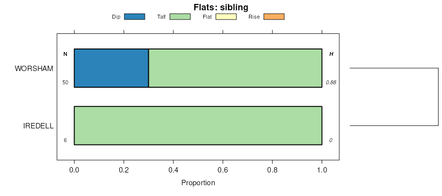
Creedmoor-Worsham sandy loams, 6 to 12 percent percent slopes | 202C | 282 | 118864 | 3zpb | va041 | 1974 | 1:15840 |
Creedmoor-Worsham sandy loams, 2 to 6 percent slopes | 202B | 19 | 118863 | 3zp9 | va041 | 1974 | 1:15840 |
Brickhaven-Creedmoor complex, 2 to 7 percent slopes | 5B | 7552 | 1587395 | 1q8t9 | va049 | 2005 | 1:24000 |
Brickhaven-Creedmoor complex, 7 to 15 percent slopes | 5C | 2295 | 1587396 | 1q8tb | va049 | 2005 | 1:24000 |
Creedmoor fine sandy loam, 2 to 7 percent slopes | 8B | 2353 | 119062 | 3zwq | va075 | 1976 | 1:15840 |
Creedmoor fine sandy loam, 2 to 7 percent slopes, eroded | 8B2 | 1304 | 119063 | 3zwr | va075 | 1976 | 1:15840 |
Creedmoor fine sandy loam, 7 to 15 percent slopes, eroded | 8C2 | 1199 | 119065 | 3zwt | va075 | 1976 | 1:15840 |
Creedmoor fine sandy loam, 7 to 15 percent slopes | 8C | 366 | 119064 | 3zws | va075 | 1976 | 1:15840 |
Mayodan-Creedmoor complex, 2 to 7 percent slopes | 45B | 1395 | 119123 | 3zyp | va085 | 1976 | 1:15840 |
Creedmoor fine sandy loam, 2 to 7 percent slopes | 19B | 600 | 119086 | 3zxh | va085 | 1976 | 1:15840 |
Creedmoor variant fine sandy loam, 2 to 7 percent slopes | 20B | 350 | 119089 | 3zxl | va085 | 1976 | 1:15840 |
Creedmoor sandy loam, 2 to 6 percent slopes, eroded | CvB2 | 529 | 119224 | 401y | va087 | 1973 | 1:15840 |
Creedmoor sandy loam, 2 to 6 percent slopes | CvB | 420 | 119223 | 401x | va087 | 1973 | 1:15840 |
Creedmoor sandy loam, 6 to 10 percent slopes, eroded | CvC2 | 250 | 119225 | 401z | va087 | 1973 | 1:15840 |
Creedmoor fine sandy loam, 1 to 4 percent slopes | 7B | 17 | 122396 | 43c8 | va089 | 1995 | 1:24000 |
Calverton and Creedmoor silt loams, 0 to 7 percent slopes | CbB | 531 | 516940 | kbxh | va113 | 1967 | 1:15840 |
Creedmoor fine sandy loam, 2 to 7 percent slopes | 9B | 3280 | 120217 | 412z | va145 | 1984 | 1:15840 |
Creedmoor fine sandy loam, undulating phase | Ct | 1434 | 120250 | 4141 | va147 | 1950 | 1:20000 |
Creedmoor fine sandy loam, rolling phase | Cs | 393 | 120249 | 4140 | va147 | 1950 | 1:20000 |
Creedmoor fine sandy loam, eroded rolling phase | Cr | 281 | 120248 | 413z | va147 | 1950 | 1:20000 |