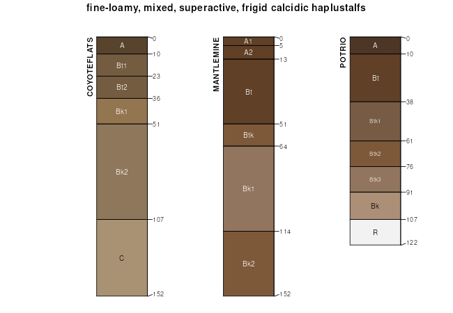
| Coyoteflats loam, 4 to 15 percent slopes | 233D | 38 | 2450947 | 2n8dt | mt605 | 2007 | 1:24000 |
Coyoteflats loam, 0 to 4 percent slopes | 133B | 13281 | 1677437 | 1t9hw | mt612 | 2011 | 1:24000 |
Varney-Coyoteflats complex, 2 to 8 percent slopes | 133C | 8718 | 798346 | vsr3 | mt612 | 2011 | 1:24000 |
Coyoteflats, stony-Deepone complex, 1 to 8 percent slopes | 137C | 7032 | 1907908 | 221bf | mt612 | 2011 | 1:24000 |
Dyce, very stony-Coyoteflats-Rock outcrop complex, 8 to 35 percent slopes | 40E | 5348 | 1468800 | 1l9dn | mt612 | 2011 | 1:24000 |
Coyoteflats loam, 4 to 15 percent slopes | 233D | 4017 | 1883940 | 217d8 | mt612 | 2011 | 1:24000 |
Dyce, very stony-Coyoteflats-Mannixlee, rarely flooded complex, 1 to 25 percent slopes | 440E | 2282 | 1672385 | 1t47x | mt612 | 2011 | 1:24000 |
Trimad, extremely stony-Coyoteflats, rubbly-Trimad complex, 4 to 15 percent slopes | 200D | 1066 | 2383078 | 2kzsh | mt612 | 2011 | 1:24000 |
Brockway-Coyoteflats, stony-Trudau complex, 1 to 8 percent slopes | 63C | 775 | 2247808 | 2fg0y | mt612 | 2011 | 1:24000 |
Bronec-Coyoteflats complex, 8 to 35 percent slopes, extremely stony | 286E | 331 | 2409992 | 2lwsp | mt612 | 2011 | 1:24000 |
Trimad, extremely stony-Coyoteflats, rubbly-Trimad complex, 4 to 15 percent slopes | 200D | 141 | 3162834 | 2kzsh | mt614 | 2012 | 1:24000 |
Varney-Coyoteflats complex, 2 to 4 percent slopes | 854B | 42 | 2523234 | 4z2r | mt624 | 2021 | 1:24000 |
Varney, stony-Coyoteflats, very stony complex, cool, 2 to 8 percent slopes | 955C | 4333 | 1487641 | 1ly0f | mt637 | 2014 | 1:24000 |
Coyoteflats, very stony-Beaverell complex, cool, 0 to 4 percent slopes | 153B | 3229 | 1537460 | 1nlvh | mt637 | 2014 | 1:24000 |
Fortlogan-Coyoteflats-Cabbart complex, cool, 2 to 8 percent slopes | 268C | 2396 | 1529235 | 1nb95 | mt637 | 2014 | 1:24000 |
Coyoteflats cobbly loam, cool, 2 to 8 percent slopes | 754C | 2247 | 148072 | 4z2j | mt637 | 2014 | 1:24000 |
Coyoteflats-Crago complex, cool, 1 to 4 percent slopes | 654B | 1617 | 148062 | 4z26 | mt637 | 2014 | 1:24000 |
Varney-Coyoteflats complex, 2 to 4 percent slopes | 854B | 1518 | 148079 | 4z2r | mt637 | 2014 | 1:24000 |
Coyoteflats cobbly loam, cool, 0 to 2 percent slopes | 754B | 1414 | 148071 | 4z2h | mt637 | 2014 | 1:24000 |
Assinniboine-Coyoteflats complex, cool, 2 to 8 percent slopes | 49C | 1133 | 1536810 | 1nl5j | mt637 | 2014 | 1:24000 |
Varney-Coyoteflats complex, 4 to 8 percent slopes | 854C | 914 | 148080 | 4z2s | mt637 | 2014 | 1:24000 |
Varney-Coyoteflats complex, cool, 0 to 4 percent slopes | 155B | 904 | 1537062 | 1nlfn | mt637 | 2014 | 1:24000 |
Coyoteflats-Fortlogan-Nebies, very stony, complex, cool, 2 to 8 percent slopes | 855C | 800 | 1487024 | 1lxcj | mt637 | 2014 | 1:24000 |
Coyoteflats-Foreleft complex, 10 to 25 percent slopes | B408 | 460 | 3170928 | 2wxml | wy603 | | 1:24000 |
Coyoteflats-Amalia complex, 2 to 8 percent slopes | 2215 | 179 | 3170926 | 2wxkw | wy603 | | 1:24000 |
Coyoteflats-Chinatown complex, 2 to 10 percent slopes | 2226 | 9323 | 2911917 | 2w7jr | wy629 | | 1:24000 |
Coyoteflats gravelly sandy loam, 10 to 25 percent slopes | 5440 | 5053 | 2911913 | 2w7jm | wy629 | | 1:24000 |
Twinadams-like, stony-Coyoteflats, very stony-Birney, very bouldery complex, 20 to 60 percent slopes | 2417 | 4097 | 3209040 | 2zdq4 | wy629 | | 1:24000 |
Coyoteflats-Tymosling, stony-Bondoe, stony complex, 8 to 20 percent slopes | 5330 | 1696 | 3136881 | 2yppk | wy629 | | 1:24000 |
Rangecreek-Coyoteflats-Rock outcrop complex, 15 to 60 percent slopes | 5512 | 1472 | 2911884 | 2w7hs | wy629 | | 1:24000 |
Coyoteflats-Foreleft complex, 10 to 25 percent slopes | 2408 | 1457 | 2969093 | 2wxml | wy629 | | 1:24000 |
Coyoteflats-Delpoint complex, 6 to 35 percent slopes | 5479 | 987 | 3203042 | 2zbr1 | wy629 | | 1:24000 |
Coyoteflats-Tymosling, very bouldery-Ratsnest-like complex, 20 to 50 percent slopes | 5905 | 868 | 3171004 | 2z214 | wy629 | | 1:24000 |
Dunlap-like-Coyoteflats-Udecide-like complex, 2 to 8 percent slopes | 5233 | 788 | 3203084 | 2zbsh | wy629 | | 1:24000 |
Coyoteflats-Foreleft-Yamacall complex, 3 to 15 percent slopes | 325 | 745 | 2483448 | 2pc77 | wy629 | | 1:24000 |
Foreleft-like-Bronec, very stony-Coyoteflats, very bouldery complex, 8 to 40 percent slopes | 9443 | 527 | 3170998 | 2z20y | wy629 | | 1:24000 |
Coyoteflats-Crago-like-Cambarge-like complex, 20 to 50 percent slopes | 2505 | 500 | 3170916 | 2z1yq | wy629 | | 1:24000 |
Coyoteflats, stony-Geohrock-Pachel complex, 4 to 40 percent slopes | 9450 | 333 | 3203058 | 2zbrn | wy629 | | 1:24000 |
Coyoteflats-Pinehill complex, 6 to 15 percent slopes | 2350 | 330 | 3250476 | 2zv71 | wy629 | | 1:24000 |
Foreleft-Colstrip-like-Coyoteflats complex, 8 to 30 percent slopes | 5483 | 315 | 3203032 | 2zbqp | wy629 | | 1:24000 |
Coyoteflats-Amalia-Bronec complex, 12 to 40 percent slopes | 2418 | 238 | 3206635 | 2zc4l | wy629 | | 1:24000 |
Coyoteflats-Amalia complex, 2 to 8 percent slopes | 2215 | 189 | 2969045 | 2wxkw | wy629 | | 1:24000 |
Tridell-Badland-Coyoteflats complex, 8 to 60 percent slopes | 9456 | 159 | 3253275 | 2ztjn | wy629 | | 1:24000 |
Coyoteflats fine sandy loam, 0 to 8 percent slopes | 851 | 10620 | 3365722 | 312fn | wy630 | | 1:24000 |
Coyoteflats-Whitesage-Beavwan complex, 2 to 15 percent slopes | 1304 | 5586 | 3019035 | 2xcd1 | wy630 | | 1:24000 |
Seminoe-Coyoteflats complex, 0 to 4 percent slopes | 780 | 5172 | 3410530 | 31v1m | wy630 | | 1:24000 |
Coyoteflats-Creed complex, 1 to 5 percent slopes | 890 | 4199 | 3410444 | 31g7g | wy630 | | 1:24000 |
Coyoteflats sandy loam, 1 to 7 percent slopes | 747 | 3589 | 3410474 | 31g8y | wy630 | | 1:24000 |
Coyoteflats-Raghorn complex, 3 to 15 percent slopes | 811 | 2798 | 3410466 | 31g8m | wy630 | | 1:24000 |
Coyoteflats-Bonhigh complex, 2 to 8 percent slopes | 751 | 2627 | 3410494 | 31g9q | wy630 | | 1:24000 |
Coyoteflats family-Ethridge-Shooter complex, 5 to 24 percent slopes | 925 | 2539 | 3461840 | 3168v | wy630 | | 1:24000 |
Foreright-Coyoteflats-Standing Elk complex, 1 to 8 percent slopes | 749 | 2252 | 3410477 | 31g8z | wy630 | | 1:24000 |
Coyoteflats family-Assinniboine complex, 8 to 20 percent slopes | 775 | 1864 | 3410525 | 31v1g | wy630 | | 1:24000 |
Pylon, stony-Coyoteflats complex, 1 to 8 percent slopes | 814 | 1393 | 3410463 | 31g8j | wy630 | | 1:24000 |
Coyoteflats-Chickenhill-Seminoe complex, 0 to 3 percent slopes | 909 | 859 | 3410569 | 31v2q | wy630 | | 1:24000 |
Buddsoft-Bronec-Coyoteflats complex, 4 to 15 percent slopes | 1306 | 736 | 3019038 | 2xcd3 | wy630 | | 1:24000 |
Ethridge-Snakerattle-Coyoteflats family complex, 2 to 10 percent slopes | 920 | 637 | 3461830 | 3168p | wy630 | | 1:24000 |
Coyoteflats family-Seminoe-Evanston complex, 0 to 8 percent slopes | 921 | 631 | 3461833 | 3168q | wy630 | | 1:24000 |
Coyoteflats family-Assinniboine-Gurley complex, 2 to 12 percent slopes | 919 | 598 | 3410561 | 3168n | wy630 | | 1:24000 |
Coyoteflats loam, 0 to 10 percent slopes | 436 | 402 | 2617834 | 2rb2w | wy630 | | 1:24000 |
Coyoteflats loam, 1 to 4 percent slopes | 2226 | 9156 | 2482451 | 2pb62 | wy635 | | 1:24000 |
Coyoteflats-Spang complex, 2 to 15 percent slopes | 5421 | 1729 | 1904866 | 21y59 | wy635 | | 1:24000 |
Twinadams-like, stony-Coyoteflats, very stony-Birney, very bouldery complex, 20 to 60 percent slopes | 2417 | 84 | 3250516 | 2zdq4 | wy656 | 2008 | 1:24000 |
Coyoteflats-Amalia-Bronec complex, 12 to 40 percent slopes | 2418 | 21 | 3250517 | 2zc4l | wy656 | 2008 | 1:24000 |
Coyoteflats-Weed complex, 4 to 15 percent slopes -- draft | 5436 | 1937 | 2515443 | 2qcst | wy723 | | 1:24000 |
Fogarty-Coyoteflats-Foreright complex, 4 to 15 percent slopes | 2728 | 780 | 2925281 | 2wdk7 | wy723 | | 1:24000 |
Coyoteflats loam, 0 to 3 percent slopes -- draft | 511A | 367 | 503378 | jwt0 | wy723 | | 1:24000 |
Hangmans-Coyoteflats-Bonhigh family, complex, 2 to 8 percent slopes | 3432 | 18234 | 2611944 | 2qstm | wy737 | | 1:24000 |
Coyoteflats-Bonhigh-Hawkdepth family, complex, 1 to 8 percent slopes | 4311 | 3851 | 3222432 | 2zjtt | wy737 | | 1:24000 |
Zagplat-Bonhigh family-Coyoteflats complex, 0 to 2 percent slopes | 905 | 1300 | 3017432 | 2xbrm | wy737 | | 1:24000 |