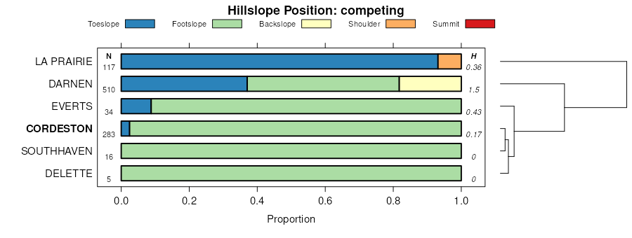
| Cordeston-Rapidcreek, rarely flooded complex, dry, 2 to 9 percent slopes | Q0620C | 18 | 2516997 | 2krlh | sd047 | 1980 | 1:24000 |
Cordeston-Marshbrook loams, 0 to 6 percent slopes, flooded | Q0206B | 4856 | 2375701 | 2kr3j | sd081 | 2007 | 1:24000 |
Bullflat, moist-Cordeston silt loams, 2 to 9 percent slopes | Q0502C | 678 | 2375731 | 2kr4h | sd081 | 2007 | 1:24000 |
Heely-Cordeston complex, 2 to 15 percent slopes | Q0209D | 665 | 2375670 | 2kr2j | sd081 | 2007 | 1:24000 |
Marshbrook-Cordeston loams, 2 to 9 percent slopes, flooded | Q0217C | 618 | 2375685 | 2kr30 | sd081 | 2007 | 1:24000 |
Cordeston loam, 1 to 6 percent slopes, flooded | Q0518B | 616 | 2513756 | 2mv3f | sd081 | 2007 | 1:24000 |
Cordeston-Rapidcreek, rarely flooded complex, 2 to 9 percent slopes | Q0520C | 277 | 2375752 | 2kr55 | sd081 | 2007 | 1:24000 |
Cordeston loam, 6 to 10 percent slopes | Q0518C | 255 | 2427154 | 2mgn9 | sd081 | 2007 | 1:24000 |
Bullflat, moist-Cordeston silt loams, 2 to 9 percent slopes | Q0502C | 174 | 2513958 | 2kr4h | sd600 | 1974 | 1:24000 |
Marshbrook-Cordeston loams, 2 to 9 percent slopes, flooded | Q0217C | 94 | 2514525 | 2kr30 | sd600 | 1974 | 1:24000 |
Cordeston-Rapidcreek, rarely flooded complex, 2 to 9 percent slopes | Q0520C | 87 | 2513965 | 2kr55 | sd600 | 1974 | 1:24000 |
Cordeston loam, 1 to 6 percent slopes, flooded | Q0518B | 59 | 2513758 | 2mv3f | sd600 | 1974 | 1:24000 |
Cordeston-Rapidcreek, rarely flooded complex, dry, 2 to 9 percent slopes | Q0620C | 54 | 2516996 | 2krlh | sd600 | 1974 | 1:24000 |
Cordeston loam, 6 to 10 percent slopes | Q0518C | 48 | 2513943 | 2mgn9 | sd600 | 1974 | 1:24000 |
Bullflat-Cordeston, dry silt loams, high mica, 2 to 9 percent slopes | Q0300C | 6899 | 2586606 | 2krjf | sd607 | 2011 | 1:24000 |
Cordeston-Marshbrook loams, 0 to 6 percent slopes, flooded | Q0206B | 6600 | 2586634 | 2kr3j | sd607 | 2011 | 1:24000 |
Heely-Cordeston complex, 2 to 15 percent slopes | Q0209D | 6064 | 2586551 | 2kr2j | sd607 | 2011 | 1:24000 |
Bullflat-Cordeston, dry silt loams, 2 to 9 percent slopes | Q0609C | 5774 | 2586417 | 2mhnl | sd607 | 2011 | 1:24000 |
Cordeston-Rapidcreek, rarely flooded complex, dry, 2 to 9 percent slopes | Q0620C | 4656 | 2586442 | 2krlh | sd607 | 2011 | 1:24000 |
Cordeston loams, dry, high mica, 2 to 10 percent slopes, flooded | Q0306C | 4386 | 2586580 | 2krjw | sd607 | 2011 | 1:24000 |
Cordeston, dry-Marshbrook loams, 0 to 6 percent slopes, flooded | Q0307B | 4260 | 2586448 | 2krjx | sd607 | 2011 | 1:24000 |
Cordeston loam, high mica, 2 to 10 percent slopes, flooded | Q0205C | 3993 | 2586630 | 2kr8s | sd607 | 2011 | 1:24000 |
Heely-Cordeston complex, dry, 6 to 15 percent slopes | Q0310D | 3684 | 2586462 | 2krk0 | sd607 | 2011 | 1:24000 |
Bullflat, moist-Cordeston silt loams, 2 to 9 percent slopes | Q0502C | 1814 | 2586591 | 2kr4h | sd607 | 2011 | 1:24000 |
Bullflat, moist-Cordeston silt loams, high mica, 2 to 9 percent slopes | Q0200C | 1492 | 2586612 | 2kr29 | sd607 | 2011 | 1:24000 |
Cordeston loam, dry, 2 to 10 percent slopes | Q0619C | 904 | 2586450 | 2mhx2 | sd607 | 2011 | 1:24000 |
Cordeston-Rapidcreek, rarely flooded complex, 2 to 9 percent slopes | Q0520C | 753 | 2586412 | 2kr55 | sd607 | 2011 | 1:24000 |
Cordeston loam, 1 to 6 percent slopes, flooded | Q0518B | 8306 | 2513757 | 2mv3f | wy011 | 1978 | 1:24000 |
Cordeston-Hickok loams, 2 to 6 percent slopes | Q0519B | 2489 | 2438907 | 2mvwf | wy011 | 1978 | 1:24000 |
Cordeston loam, 6 to 10 percent slopes | Q0518C | 945 | 2513942 | 2mgn9 | wy011 | 1978 | 1:24000 |
Cordeston silt loams, 0 to 3 percent slopes, flooded | Q0813A | 621 | 2439233 | 2mw6y | wy011 | 1978 | 1:24000 |
Nunnston, thick surface-Cordeston loams, 1 to 6 percent slopes | Q0913B | 338 | 2441286 | 2myc5 | wy011 | 1978 | 1:24000 |
Cordeston, warm-Lakoa loams, 2 to 6 percent slopes | P094B | 202 | 2768171 | 2rwdw | wy011 | 1978 | 1:24000 |
Cordeston loam, high mica, 2 to 10 percent slopes, flooded | Q0205C | 65 | 2516983 | 2kr8s | wy011 | 1978 | 1:24000 |
Cordeston loam, dry, 0 to 6 percent slopes | P092B | 43 | 2768174 | 2rxtn | wy011 | 1978 | 1:24000 |
Cordeston loam, 1 to 6 percent slopes, flooded | Q0518B | 1777 | 2438163 | 2mv3f | wy045 | 1984 | 1:24000 |
Cordeston loam, dry, 0 to 6 percent slopes | P092B | 1737 | 2745971 | 2rxtn | wy045 | 1984 | 1:24000 |
Cordeston loam, 6 to 10 percent slopes | Q0518C | 25 | 2513941 | 2mgn9 | wy045 | 1984 | 1:24000 |


