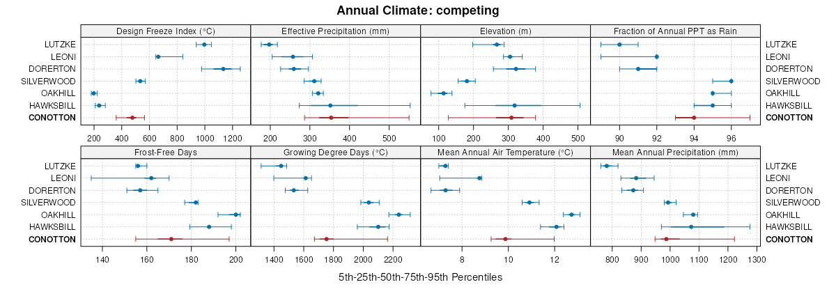
| Conotton sandy loam, 0 to 3 percent slopes | CoA | 6117 | 164471 | 5j4j | in083 | 1979 | 1:15840 |
Chili and Conotton gravelly loams, 12 to 18 percent slopes | CkD | 2447 | 288150 | 9nv5 | oh005 | 1976 | 1:15840 |
Chili and Conotton gravelly loams, 18 to 35 percent slopes | CkE | 1096 | 288151 | 9nv6 | oh005 | 1976 | 1:15840 |
Chili and Conotton soils, 12 to 18 percent slopes | CoD | 16 | 1592605 | 1qg7c | oh005 | 1976 | 1:15840 |
Chili and Conotton soils, 18 to 25 percent slopes | CoE | 12 | 1592606 | 1qg7d | oh005 | 1976 | 1:15840 |
Conotton gravelly loam, 2 to 12 percent slopes | CsC | 1 | 1592607 | 1qg7f | oh005 | 1976 | 1:15840 |
Conotton gravelly loam, 2 to 6 percent slopes | CmB | 431 | 298752 | b0w5 | oh029 | 2005 | 1:12000 |
Conotton gravelly loam, 6 to 12 percent slopes | CmC | 201 | 298753 | b0w6 | oh029 | 2005 | 1:12000 |
Conotton loam, 2 to 6 percent slopes | CtB | 940 | 172126 | 5s3g | oh043 | 1998 | 1:12000 |
Conotton gravelly loam, 6 to 12 percent slopes | CuC | 146 | 172127 | 5s3h | oh043 | 1998 | 1:12000 |
Chili and Conotton gravelly loams, 18 to 35 percent slopes | CrE | 5 | 1677341 | 1t9ds | oh075 | 1989 | 1:15840 |
Chili and Conotton gravelly loams, 12 to 18 percent slopes | CrD | 4 | 1677340 | 1t9dr | oh075 | 1989 | 1:15840 |
Conotton gravelly loam, 2 to 6 percent slopes | CyB | 1278 | 286798 | 9mfk | oh085 | 1976 | 1:15840 |
Conotton loam, 0 to 2 percent slopes | CxA | 697 | 286797 | 9mfj | oh085 | 1976 | 1:15840 |
Conotton gravelly loam, 6 to 15 percent slopes | CyC | 132 | 286799 | 9mfl | oh085 | 1976 | 1:15840 |
Conotton gravelly loam, 2 to 6 percent slopes | CoB | 441 | 287748 | 9nf6 | oh093 | 1972 | 1:15840 |
Conotton gravelly loam, 6 to 12 percent slopes | CoC | 62 | 287749 | 9nf7 | oh093 | 1972 | 1:15840 |
Chili and Conotton gravelly soils, 18 to 25 percent slopes | CnE | 297 | 816741 | wdwh | oh099 | 1966 | 1:15840 |
Chili and Conotton gravelly soils, 25 to 50 percent slopes | CnF | 149 | 816742 | wdwj | oh099 | 1966 | 1:15840 |
Conotton gravelly loam, 0 to 2 percent slopes | CnA | 746 | 537147 | 2xqwf | oh105 | 1991 | 1:15840 |
Conotton gravelly loam, 18 to 40 percent slopes | CnE | 278 | 537149 | 2xqwp | oh105 | 1991 | 1:15840 |
Conotton gravelly loam, 6 to 12 percent slopes | CnC | 153 | 537148 | 2xqwm | oh105 | 1991 | 1:15840 |
Conotton gravelly loam, 0 to 2 percent slopes | CoA | 108 | 537759 | 2xqwf | oh111 | 1968 | 1:15840 |
Conotton gravelly loam, 6 to 18 percent slopes | CoD | 96 | 537760 | 2xqwn | oh111 | 1968 | 1:15840 |
Conotton gravelly loam, 3 to 8 percent slopes | Cnt6B1 | 355 | 3175562 | 2zfvf | oh115 | 1992 | 1:15840 |
Conotton gravelly loam, 6 to 12 percent slopes, eroded | CoC2 | 216 | 537430 | 2xqwk | oh115 | 1992 | 1:15840 |
Conotton gravelly loam, 0 to 3 percent slopes | Cnt6A1 | 77 | 3175561 | 2zfvd | oh115 | 1992 | 1:15840 |
Conotton gravelly loam, 18 to 25 percent slopes, moderately eroded | CyE2 | 1 | 1717872 | 1vnl7 | oh133 | 1973 | 1:15840 |
Chili and Conotton soils, 12 to 18 percent slopes | CoD | 1427 | 170742 | 5qnt | oh139 | 1971 | 1:15840 |
Chili and Conotton soils, 18 to 25 percent slopes | CoE | 400 | 170744 | 5qnw | oh139 | 1971 | 1:15840 |
Conotton gravelly loam, 2 to 12 percent slopes | CtC | 247 | 170747 | 5qnz | oh139 | 1971 | 1:15840 |
Chili and Conotton soils, 12 to 18 percent slopes, severely eroded | CoD3 | 138 | 170743 | 5qnv | oh139 | 1971 | 1:15840 |
Chili and Conotton soils, 25 to 40 percent slopes | CoF | 104 | 170745 | 5qnx | oh139 | 1971 | 1:15840 |
Chili and Conotton gravelly loams, 25 to 50 percent slopes, moderately eroded | CvF2 | 1495 | 287981 | 9nnq | oh151 | 1967 | 1:15840 |
Conotton gravelly loam, 12 to 18 percent slopes, moderately eroded | CyD2 | 1190 | 287985 | 9nnv | oh151 | 1967 | 1:15840 |
Conotton gravelly loam, 18 to 25 percent slopes, moderately eroded | CyE2 | 969 | 287986 | 9nnw | oh151 | 1967 | 1:15840 |
Conotton gravelly loam, 6 to 12 percent slopes | CyC | 486 | 287984 | 9nnt | oh151 | 1967 | 1:15840 |
Conotton gravelly loam, 2 to 6 percent slopes | CyB | 335 | 287983 | 9nns | oh151 | 1967 | 1:15840 |
Conotton loam, 0 to 2 percent slopes | CwA | 217 | 287982 | 9nnr | oh151 | 1967 | 1:15840 |
Conotton gravelly loam, 15 to 25 percent slopes | CcD | 36 | 1595459 | 1qk6f | oh151 | 1967 | 1:15840 |
Conotton-Oshtemo complex, 12 to 18 percent slopes | CjD | 24 | 1595534 | 1qk8v | oh151 | 1967 | 1:15840 |
Conotton-Oshtemo complex, 12 to 18 percent slopes | CyD | 991 | 825328 | wpth | oh153 | 1969 | 1:20000 |
Conotton-Oshtemo complex, 18 to 25 percent slopes | CyE | 914 | 825329 | wptj | oh153 | 1969 | 1:20000 |
Conotton-Oshtemo complex, 25 to 50 percent slopes | CyF | 710 | 825330 | wptk | oh153 | 1969 | 1:20000 |
Chili and Conotton gravelly loams, 25 to 50 percent slopes, moderately eroded | CtF2 | 5 | 2376137 | 2krkl | oh153 | 1969 | 1:20000 |
Conotton gravelly loam, 12 to 18 percent slopes, moderately eroded | CsD2 | 3 | 2376136 | 2krkk | oh153 | 1969 | 1:20000 |
Conotton gravelly loam, 6 to 12 percent slopes | CsC | 2 | 2376135 | 2krkj | oh153 | 1969 | 1:20000 |
Conotton gravelly loam, 2 to 6 percent slopes | CsB | 1 | 2376134 | 2krkh | oh153 | 1969 | 1:20000 |
Conotton gravelly loam, 0 to 3 percent slopes | CoA | 800 | 536294 | 2xqwg | oh157 | 1981 | 1:15840 |
Conotton gravelly loam, 3 to 8 percent slopes | CoB | 330 | 536295 | 2xqwl | oh157 | 1981 | 1:15840 |
Conotton gravelly loam, 15 to 25 percent slopes | CoD | 250 | 536296 | 2xqwq | oh157 | 1981 | 1:15840 |
Conotton gravelly loam, 2 to 6 percent slopes | CvB | 69 | 1589426 | 1qbxt | oh157 | 1981 | 1:15840 |
Chili and Conotton gravelly loams, 25 to 50 percent slopes, moderately eroded | CxF2 | 2 | 1589425 | 1qbxs | oh157 | 1981 | 1:15840 |
Conotton gravelly loam, 12 to 18 percent slopes, moderately eroded | CvD2 | 1 | 1589427 | 1qbxv | oh157 | 1981 | 1:15840 |
Conotton gravelly loam, 0 to 3 percent slopes | Cnt6A1 | 270 | 3175560 | 2zfvd | oh167 | 1973 | 1:15840 |
Conotton-Chili gravelly loams, 18 to 25 percent slopes | CpE | 125 | 536467 | l07d | oh167 | 1973 | 1:15840 |
Conotton gravelly loam, 3 to 8 percent slopes | Cnt6B1 | 35 | 3175559 | 2zfvf | oh167 | 1973 | 1:15840 |
Conotton gravelly loam, 6 to 12 percent slopes | CvC | 10 | 2217029 | 2df02 | oh169 | 1981 | 1:15840 |
Urban land-Conotton complex, 0 to 8 percent slopes | UfB | 6322 | 2900313 | l6mk | pa007 | 1978 | 1:15840 |
Conotton gravelly loam, 3 to 8 percent slopes | CoB | 1151 | 2900252 | l6kl | pa007 | 1978 | 1:15840 |
Urban land-Conotton complex, 8 to 25 percent slopes | UfD | 822 | 2900314 | l6ml | pa007 | 1978 | 1:15840 |
Conotton gravelly loam, 8 to 15 percent slopes | CoC | 504 | 2900253 | l6km | pa007 | 1978 | 1:15840 |
Conotton gravelly loam, 15 to 25 percent slopes | CoD | 381 | 2900254 | l6kn | pa007 | 1978 | 1:15840 |
Conotton gravelly loam, 0 to 3 percent slopes | CtA | 369 | 539308 | l361 | pa025 | 1960 | 1:20000 |
Conotton gravelly loam, 3 to 8 percent slopes | CtB | 51 | 539309 | l362 | pa025 | 1960 | 1:20000 |
Conotton gravelly loam, 15 to 25 percent slopes | CtD | 27 | 539310 | l363 | pa025 | 1960 | 1:20000 |
Conotton gravelly loam, 8 to 15 percent slopes | CoC | 4858 | 2900405 | l6km | pa073 | 1978 | 1:15840 |
Conotton gravelly loam, 15 to 25 percent slopes | CoD | 3604 | 2900406 | l6kn | pa073 | 1978 | 1:15840 |
Conotton gravelly loam, 3 to 8 percent slopes | CoB | 1852 | 2900404 | l6kl | pa073 | 1978 | 1:15840 |
Conotton gravelly loam, 25 to 50 percent slopes | CoF | 1437 | 2900407 | l6kp | pa073 | 1978 | 1:15840 |
Urban land-Conotton complex, 0 to 8 percent slopes | UfB | 1087 | 2900465 | l6mk | pa073 | 1978 | 1:15840 |
Urban land-Conotton complex, 8 to 25 percent slopes | UfD | 482 | 2900466 | l6ml | pa073 | 1978 | 1:15840 |
Conotton gravelly loam, 3 to 8 percent slopes | CtB | 2749 | 1948774 | 23dvp | pa095 | 2007 | 1:12000 |
Conotton gravelly loam, 8 to 15 percent slopes | CtC | 1251 | 1948775 | 23dvq | pa095 | 2007 | 1:12000 |
Conotton gravelly loam, 0 to 3 percent slopes | CtA | 905 | 1948773 | 23dvn | pa095 | 2007 | 1:12000 |
Conotton gravelly loam, 25 to 65 percent slopes | CtF | 336 | 1948777 | 23dvs | pa095 | 2007 | 1:12000 |
Conotton gravelly loam, 15 to 25 percent slopes | CtD | 316 | 1948776 | 23dvr | pa095 | 2007 | 1:12000 |
Urban land-Conotton complex, 0 to 8 percent slopes | UmB | 225 | 1948970 | 23f20 | pa095 | 2007 | 1:12000 |
Conotton gravelly sandy loam, 0 to 3 percent slopes | CoA | 262 | 1384221 | 2xqwj | wv600 | 2005 | 1:24000 |


