| Coly silt loam, 6 to 20 percent slopes | 2582 | 106993 | 2768382 | 2rhkr | ks039 | 1985 | 1:24000 |
Coly and Uly silt loams, 6 to 10 percent slopes, eroded | 2578 | 46 | 1150571 | 2twct | ks039 | 1985 | 1:24000 |
Coly-Tobin silt loams, 0 to 15 percent slopes | 2586 | 4882 | 1380358 | 2yl4p | ks047 | 1967 | 1:24000 |
Uly-Coly silt loams, 3 to 6 percent slopes, eroded | 2822 | 59 | 2768383 | 2sgv0 | ks055 | 1962 | 1:24000 |
Uly-Coly silt loams, 3 to 6 percent slopes, eroded | 2822 | 16798 | 2768384 | 2sgv0 | ks057 | 1962 | 1:24000 |
Coly-Tobin silt loams, 0 to 15 percent slopes | 2586 | 646 | 1380418 | 2yl4p | ks057 | 1962 | 1:24000 |
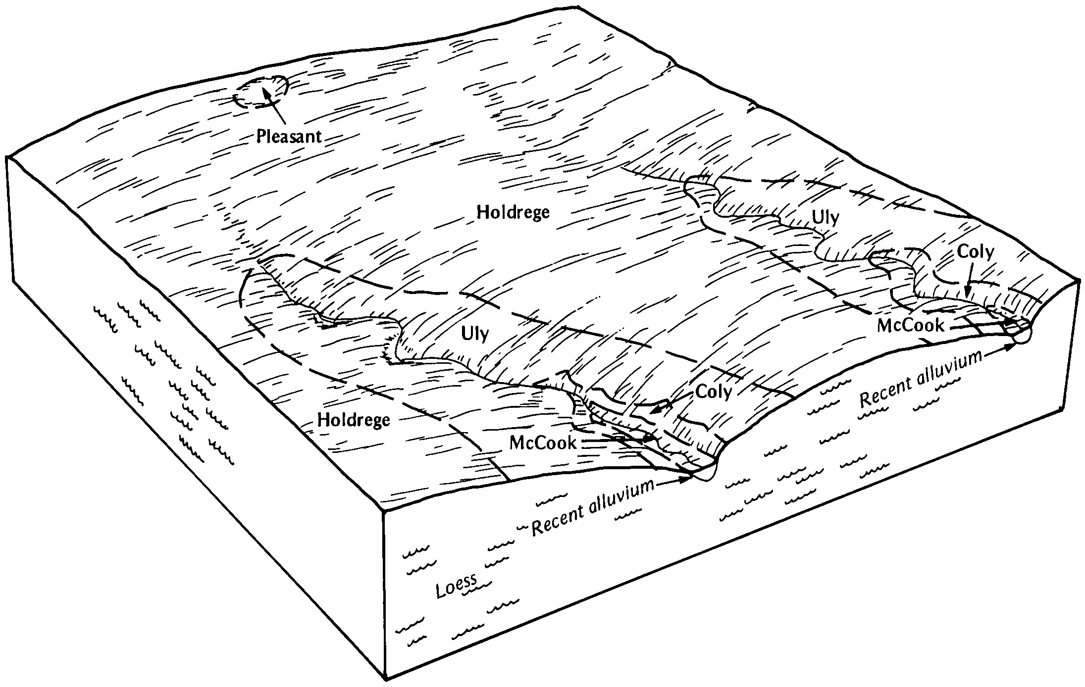
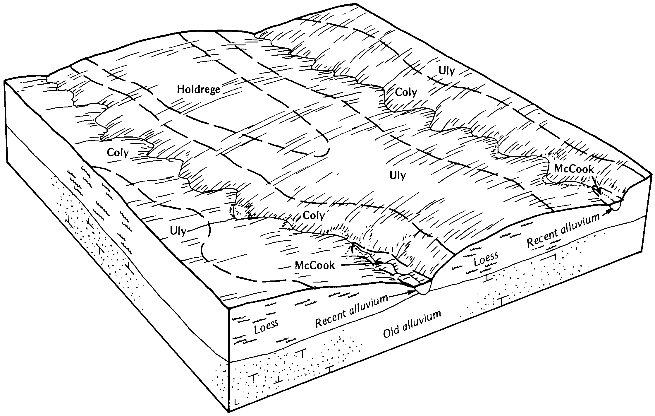
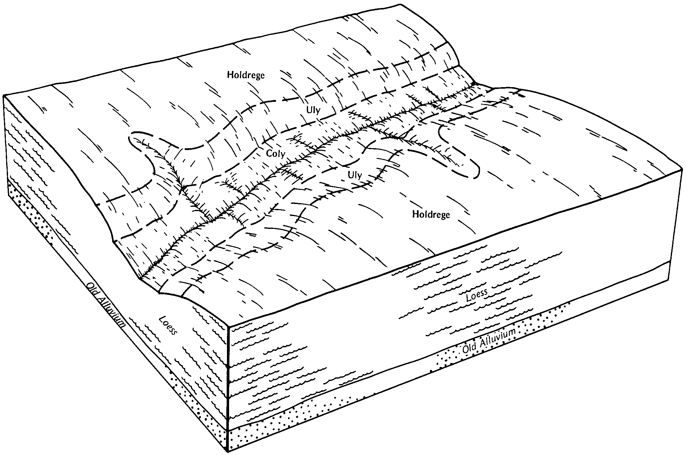
Holdrege-Coly association, 3 to 11 percent slopes, eroded | 2677 | 9 | 1380417 | 2yjnl | ks057 | 1962 | 1:24000 |
Penden-Coly complex, 3 to 30 percent slopes | 2761 | 1538 | 1150693 | 2twf1 | ks063 | 1974 | 1:24000 |
Coly silt loam, 3 to 6 percent slopes | 2580 | 40523 | 2669022 | 2rhkc | ks065 | 1985 | 1:24000 |
Coly silt loam, 6 to 20 percent slopes | 2582 | 24999 | 1150793 | 17mhc | ks065 | 1985 | 1:24000 |
Coly and Uly silt loams, 6 to 10 percent slopes, eroded | 2578 | 572 | 1150791 | 2twct | ks065 | 1985 | 1:24000 |
Uly-Coly silt loams, 3 to 6 percent slopes, eroded | 2822 | 4452 | 2768386 | 2sgv0 | ks069 | 1965 | 1:24000 |
Uly-Coly silt loams, 3 to 6 percent slopes, eroded | 2822 | 449 | 2768387 | 2sgv0 | ks081 | 1965 | 1:24000 |
Uly-Coly silt loams, 3 to 6 percent slopes, eroded | 2822 | 3253 | 2768390 | 2sgv0 | ks083 | 1966 | 1:24000 |
Coly-Tobin silt loams, 0 to 15 percent slopes | 2586 | 202 | 1152403 | 2yl4p | ks083 | 1966 | 1:24000 |
Coly-Uly silt loams, 3 to 6 percent slopes, eroded | 2588 | 120 | 2768388 | 2sgtz | ks083 | 1966 | 1:24000 |
Penden-Coly complex, 3 to 30 percent slopes | 2761 | 119 | 1152423 | 2twf1 | ks083 | 1966 | 1:24000 |
Holdrege-Coly association, 3 to 11 percent slopes, eroded | 2677 | 22239 | 1380503 | 2yjnl | ks097 | 1983 | 1:24000 |
Coly-Tobin silt loams, 0 to 15 percent slopes | 2586 | 14148 | 1380504 | 2yl4p | ks097 | 1983 | 1:24000 |
Coly silt loam, 20 to 40 percent slopes | 2584 | 2966 | 1380502 | 2zwjr | ks097 | 1983 | 1:24000 |
Coly-Uly silt loams, 3 to 6 percent slopes, eroded | 2588 | 96 | 2768392 | 2sgtz | ks101 | 1966 | 1:24000 |
Uly-Coly silt loams, 1 to 3 percent slopes, eroded | 2821 | 12 | 1152048 | 2zwk5 | ks101 | 1966 | 1:24000 |
Penden-Coly complex, 3 to 30 percent slopes | 2761 | 25877 | 1152090 | 2twf1 | ks135 | 1971 | 1:24000 |
Coly-Uly silt loams, 3 to 6 percent slopes, eroded | 2588 | 21197 | 2768393 | 2sgtz | ks135 | 1971 | 1:24000 |
Uly-Coly silt loams, 1 to 3 percent slopes, eroded | 2821 | 9943 | 1152102 | 2zwk5 | ks135 | 1971 | 1:24000 |
Coly silt loam, 3 to 6 percent slopes | 2580 | 24 | 2669029 | 2rhkc | ks135 | 1971 | 1:24000 |
Coly and Uly silt loams, 6 to 10 percent slopes, eroded | 2578 | 85946 | 1150752 | 2twct | ks137 | 1973 | 1:24000 |
Coly and Uly silt loams, 10 to 20 percent slopes, eroded | 2579 | 5076 | 1150751 | 30dz8 | ks137 | 1973 | 1:24000 |
Coly-Tobin silt loams, 0 to 15 percent slopes | 2586 | 57 | 1380116 | 2yl4p | ks145 | 1976 | 1:24000 |
Coly and Uly silt loams, 6 to 10 percent slopes, eroded | 2578 | 1356 | 1150900 | 2twct | ks147 | 1985 | 1:24000 |
Coly silt loam, 20 to 40 percent slopes | 2584 | 952 | 1381892 | 307p2 | ks157 | 1965 | 1:24000 |
Coly silt loam, 6 to 20 percent slopes | 2582 | 1888 | 2768397 | 2rhkr | ks179 | 1982 | 1:24000 |
Coly silt loam, 3 to 6 percent slopes | 2580 | 11663 | 2733043 | 2rhkc | ks195 | 1986 | 1:24000 |
Uly-Coly silt loams, 1 to 3 percent slopes, eroded | 2821 | 11 | 1150881 | 2zwk5 | ks195 | 1986 | 1:24000 |
Coly silt loam, 11 to 30 percent slopes | 2533 | 9203 | 1691895 | 2rdfy | ne001 | 1970 | 1:20000 |
Coly silt loam, 6 to 11 percent slopes | 2537 | 1085 | 2229129 | 2tmlb | ne001 | 1970 | 1:20000 |
Coly silt loam, 30 to 60 percent slopes | 2536 | 503 | 1691931 | 1tslf | ne001 | 1970 | 1:20000 |
Coly-Hobbs silt loams, 0 to 30 percent slopes | 2521 | 346 | 2216111 | 2rdfz | ne001 | 1970 | 1:20000 |
Coly-Uly silt loams, 6 to 11 percent slopes, eroded | 2558 | 206 | 2216099 | 2vzkm | ne001 | 1970 | 1:20000 |
Coly silt loam, 6 to 11 percent slopes, eroded | 2538 | 141 | 1691894 | 1tsk7 | ne001 | 1970 | 1:20000 |
Uly-Coly silt loams, 11 to 30 percent slopes | 2830 | 61 | 2216108 | 2vzl4 | ne001 | 1970 | 1:20000 |
Coly-Uly-Hobbs silt loams, 3 to 60 percent slopes | 2560 | 6 | 2216112 | 31658 | ne001 | 1970 | 1:20000 |
Coly silt loam, 3 to 11 percent slopes | 2524 | 2 | 2876216 | 2wtk7 | ne001 | 1970 | 1:20000 |
Uly-Coly silt loams, 17 to 30 percent slopes, eroded | 2831 | 13241 | 2216664 | 2wtjw | ne011 | 1966 | 1:20000 |
Uly-Coly silt loams, 11 to 17 percent slopes, eroded | 2845 | 3040 | 2606038 | 2yd3s | ne011 | 1966 | 1:20000 |
Uly-Coly silt loams, 6 to 11 percent slopes, eroded | 2844 | 1233 | 2216665 | 2tml1 | ne011 | 1966 | 1:20000 |
Coly silt loam, 6 to 11 percent slopes, eroded | 2538 | 402 | 2400504 | 2tmld | ne011 | 1966 | 1:20000 |
Coly silt loam, 17 to 30 percent slopes | 2534 | 4 | 2216655 | 2ddm0 | ne011 | 1966 | 1:20000 |
Coly, Uly and Hobbs soils, 3 to 30 percent slopes | 2544 | 66440 | 1700044 | 2vzkj | ne019 | 1967 | 1:20000 |
Coly silt loam, 6 to 11 percent slopes | 2537 | 65361 | 1700036 | 2tmlb | ne019 | 1967 | 1:20000 |
Uly, Holdrege and Coly soils, 6 to 11 percent slopes, eroded | 2843 | 39642 | 1700086 | 2vzl6 | ne019 | 1967 | 1:20000 |
Coly silt loam, 11 to 30 percent slopes | 2533 | 33402 | 1700037 | 2rdfx | ne019 | 1967 | 1:20000 |
Kenesaw-Coly silt loams, 3 to 6 percent slopes | 9071 | 5086 | 1700060 | 2yd45 | ne019 | 1967 | 1:20000 |
Coly-Hobbs silt loams, 0 to 30 percent slopes | 2521 | 5048 | 1700035 | 2rdff | ne019 | 1967 | 1:20000 |
Uly-Coly silt loams, 17 to 30 percent slopes, eroded | 2831 | 2756 | 2605857 | 2wtjw | ne019 | 1967 | 1:20000 |
Coly-Uly silt loams, 6 to 11 percent slopes, eroded | 2558 | 1393 | 2228224 | 2vzkl | ne019 | 1967 | 1:20000 |
Coly silt loam, 11 to 17 percent slopes, eroded, cool | 2543 | 1249 | 2230803 | 2rdfw | ne019 | 1967 | 1:20000 |
Coly silt loam, 30 to 60 percent slopes | 2536 | 999 | 1700074 | 2rdfd | ne019 | 1967 | 1:20000 |
Coly silt loam, 6 to 11 percent slopes, eroded | 2538 | 569 | 2228214 | 2tmld | ne019 | 1967 | 1:20000 |
Uly, eroded-Coly silt loams, 6 to 11 percent slopes | 2825 | 249 | 2228193 | 2wtjs | ne019 | 1967 | 1:20000 |
Uly-Coly silt loams, 11 to 17 percent slopes, eroded | 2845 | 194 | 3103649 | 2yd3s | ne019 | 1967 | 1:20000 |
Coly-Hobbs silt loams, 3 to 60 percent slopes | 2539 | 73 | 2605867 | 2rdfc | ne019 | 1967 | 1:20000 |
Uly-Holdrege-Coly silt loams, 6 to 11 percent slopes, eroded | 2838 | 18 | 2228218 | 2wtjv | ne019 | 1967 | 1:20000 |
Uly-Coly silt loams, 17 to 30 percent slopes, eroded | 2831 | 6023 | 1691332 | 1trz3 | ne023 | 1979 | 1:20000 |
Coly silt loam, 30 to 60 percent slopes | 2536 | 1376 | 1691271 | 1trx4 | ne023 | 1979 | 1:20000 |
Uly-Coly silt loams, 17 to 30 percent slopes, eroded | 2831 | 332536 | 2605858 | 2wtjw | ne041 | 1980 | 1:20000 |
Coly-Hobbs silt loams, 3 to 60 percent slopes | 2539 | 137858 | 2605868 | 2rdfc | ne041 | 1980 | 1:20000 |
Coly silt loam, 11 to 17 percent slopes, eroded, cool | 2543 | 122940 | 2784455 | 2rdfw | ne041 | 1980 | 1:20000 |
Coly silt loam, 6 to 11 percent slopes, eroded | 2538 | 17640 | 1699577 | 2tmld | ne041 | 1980 | 1:20000 |
Coly-Uly-Hobbs silt loams, 3 to 60 percent slopes | 2560 | 2278 | 2228160 | 31658 | ne041 | 1980 | 1:20000 |
Uly-Coly silt loams, 11 to 17 percent slopes, eroded | 2845 | 1251 | 2228168 | 2yd3s | ne041 | 1980 | 1:20000 |
Coly-Hobbs silt loams, 0 to 30 percent slopes | 2521 | 1051 | 2228165 | 2rdff | ne041 | 1980 | 1:20000 |
Coly-Uly silt loams, 6 to 11 percent slopes, eroded | 2558 | 595 | 2228169 | 2vzkl | ne041 | 1980 | 1:20000 |
Coly silt loam, 11 to 30 percent slopes | 2533 | 39 | 2228185 | 2rdfx | ne041 | 1980 | 1:20000 |
Uly and Coly silt loams, 11 to 30 percent slopes | 2810 | 25 | 2768400 | 2rhkm | ne041 | 1980 | 1:20000 |
Uly-Holdrege-Coly silt loams, 6 to 11 percent slopes, eroded | 2838 | 15 | 2228166 | 2wtjv | ne041 | 1980 | 1:20000 |
Coly silt loam, 6 to 11 percent slopes | 2537 | 5 | 2228159 | 2tmlb | ne041 | 1980 | 1:20000 |
Uly-Coly silt loams, 17 to 30 percent slopes, eroded | 2831 | 102433 | 2605860 | 2wtjw | ne047 | 1975 | 1:20000 |
Coly-Uly-Hobbs silt loams, 3 to 60 percent slopes | 2560 | 29215 | 1699664 | 31658 | ne047 | 1975 | 1:20000 |
Coly silt loam, 11 to 17 percent slopes, eroded, cool | 2543 | 27972 | 2784460 | 2rdfw | ne047 | 1975 | 1:20000 |
Coly silt loam, 6 to 11 percent slopes, eroded | 2538 | 19847 | 1699662 | 2tmld | ne047 | 1975 | 1:20000 |
Coly-Hobbs silt loams, 0 to 30 percent slopes | 2521 | 10876 | 1699674 | 2rdff | ne047 | 1975 | 1:20000 |
Uly-Holdrege-Coly silt loams, 6 to 11 percent slopes, eroded | 2838 | 3593 | 1699717 | 2wtjv | ne047 | 1975 | 1:20000 |
Coly silt loam, 11 to 17 percent slopes, eroded | 2541 | 3107 | 1699663 | 31656 | ne047 | 1975 | 1:20000 |
Coly, Uly and Hobbs soils, 3 to 30 percent slopes | 2544 | 1865 | 2228814 | 2vzkj | ne047 | 1975 | 1:20000 |
Coly and Uly silt loams, 11 to 30 percent slopes | 2529 | 1272 | 2745891 | 2rhkk | ne047 | 1975 | 1:20000 |
Uly-Coly silt loams, 11 to 30 percent slopes | 2830 | 733 | 2745893 | 2rhkl | ne047 | 1975 | 1:20000 |
Coly-Hobbs silt loams, 3 to 60 percent slopes | 2539 | 536 | 2605869 | 2rdfc | ne047 | 1975 | 1:20000 |
Uly and Coly silt loams, 6 to 11 percent slopes, eroded | 2809 | 170 | 2228808 | 30znz | ne047 | 1975 | 1:20000 |
Uly and Coly silt loams, 11 to 30 percent slopes | 2810 | 15 | 2768401 | 2rhkm | ne047 | 1975 | 1:20000 |
Coly-Uly silt loams, 11 to 30 percent slopes | 2559 | 23064 | 2768404 | 2rhkn | ne061 | 1974 | 1:20000 |
Coly-Uly silt loams, 3 to 11 percent slopes, eroded | 2557 | 13703 | 2768403 | 2sgv2 | ne061 | 1974 | 1:20000 |
Coly silt loam, 30 to 60 percent slopes | 2536 | 3668 | 1691983 | 1tsn3 | ne061 | 1974 | 1:20000 |
Uly-Coly silt loams, 11 to 30 percent slopes | 2830 | 1794 | 2219313 | 2vzl4 | ne061 | 1974 | 1:20000 |
Coly-Uly silt loams, 6 to 11 percent slopes, eroded | 2558 | 194 | 2219312 | 2vzkm | ne061 | 1974 | 1:20000 |
Coly-Uly-Hobbs silt loams, 3 to 60 percent slopes | 2560 | 58 | 2219308 | 31658 | ne061 | 1974 | 1:20000 |
Coly-Uly silt loams, 11 to 17 percent slopes, eroded | 2555 | 17 | 2876152 | 2pf1l | ne061 | 1974 | 1:20000 |
Coly and Uly silt loams, 11 to 30 percent slopes | 2529 | 263078 | 2745896 | 2rhkk | ne063 | 1973 | 1:20000 |
Uly and Coly silt loams, 11 to 30 percent slopes | 2810 | 24250 | 2768409 | 2rhkm | ne063 | 1973 | 1:20000 |
Coly-Uly-Hobbs silt loams, 3 to 60 percent slopes | 2560 | 14579 | 1699420 | 31658 | ne063 | 1973 | 1:20000 |
Coly silt loam, 11 to 17 percent slopes, eroded | 2541 | 8107 | 1699396 | 31656 | ne063 | 1973 | 1:20000 |
Uly-Coly silt loams, 11 to 30 percent slopes | 2830 | 6711 | 2745899 | 2rhkl | ne063 | 1973 | 1:20000 |
Coly-Uly silt loams, 11 to 30 percent slopes | 2559 | 5814 | 2768407 | 2rhkn | ne063 | 1973 | 1:20000 |
Uly and Coly silt loams, 6 to 11 percent slopes, eroded | 2809 | 4360 | 1699425 | 30znz | ne063 | 1973 | 1:20000 |
Coly silt loam, 6 to 11 percent slopes | 2537 | 4025 | 2219369 | 2tmlb | ne063 | 1973 | 1:20000 |
Holdrege-Coly silt loams, 1 to 3 percent slopes, eroded | 4151 | 47 | 2219379 | 2wsf2 | ne063 | 1973 | 1:20000 |
Coly-Nuckolls silt loams, 11 to 30 percent slopes | 2549 | 40 | 2219373 | 2zwjt | ne063 | 1973 | 1:20000 |
Coly silt loam, 6 to 11 percent slopes, eroded | 2538 | 19 | 1699395 | 1v1c6 | ne063 | 1973 | 1:20000 |
Coly-Uly silt loams, 3 to 11 percent slopes, eroded | 2557 | 9 | 2768406 | 2sgv2 | ne063 | 1973 | 1:20000 |
Holdrege-Coly silt loams, 3 to 7 percent slopes, eroded | 4152 | 7 | 2219380 | 2wsf3 | ne063 | 1973 | 1:20000 |
Uly-Coly silt loams, 17 to 30 percent slopes, eroded | 2831 | 5 | 2219370 | 2wtjw | ne063 | 1973 | 1:20000 |
Coly-Uly silt loams, 11 to 30 percent slopes | 2559 | 63453 | 2768412 | 2rhkn | ne065 | 1975 | 1:20000 |
Coly-Nuckolls silt loams, 11 to 30 percent slopes | 2549 | 46741 | 1699733 | 2zwjt | ne065 | 1975 | 1:20000 |
Coly-Uly silt loams, 3 to 11 percent slopes, eroded | 2557 | 40322 | 2768411 | 2sgv2 | ne065 | 1975 | 1:20000 |
Coly silt loam, 11 to 17 percent slopes, eroded | 2541 | 12620 | 1699729 | 31656 | ne065 | 1975 | 1:20000 |
Coly-Nuckolls silt loams, 11 to 17 percent slopes, eroded | 2548 | 4439 | 1699732 | 2zwjs | ne065 | 1975 | 1:20000 |
Coly silt loam, 30 to 60 percent slopes | 2536 | 4003 | 1699730 | 1v1q0 | ne065 | 1975 | 1:20000 |
Holdrege-Coly silt loams, 3 to 7 percent slopes, eroded | 4152 | 3031 | 1699752 | 2wsf3 | ne065 | 1975 | 1:20000 |
Holdrege-Coly silt loams, 1 to 3 percent slopes, eroded | 4151 | 2031 | 1699751 | 2wsf2 | ne065 | 1975 | 1:20000 |
Coly silt loam, 6 to 11 percent slopes, eroded | 2538 | 164 | 2219432 | 2dhhl | ne065 | 1975 | 1:20000 |
Coly-Uly-Hobbs silt loams, 3 to 60 percent slopes | 2560 | 13 | 2219433 | 31658 | ne065 | 1975 | 1:20000 |
Coly and Uly silt loams, 3 to 11 percent slopes, eroded | 2528 | 10 | 2768410 | 2sgv1 | ne065 | 1975 | 1:20000 |
Coly and Nuckolls silt loams, 11 to 30 percent slopes, eroded | 2526 | 10 | 2219438 | 2wsdv | ne065 | 1975 | 1:20000 |
Uly-Coly silt loams, 17 to 30 percent slopes, eroded | 2831 | 7102 | 2605861 | 2wtjw | ne071 | 1984 | 1:20000 |
Coly-Hobbs silt loams, 3 to 60 percent slopes, moist | 2540 | 6831 | 2606051 | 2pf1p | ne071 | 1984 | 1:20000 |
Coly-Hobbs silt loams, 3 to 60 percent slopes | 2539 | 2185 | 2605870 | 2rdfc | ne071 | 1984 | 1:20000 |
Uly-Coly silt loams, 11 to 17 percent slopes, eroded | 2845 | 1697 | 1699809 | 2yd3s | ne071 | 1984 | 1:20000 |
Uly-Coly silt loams, 6 to 11 percent slopes, eroded | 2844 | 1305 | 1699808 | 2tml1 | ne071 | 1984 | 1:20000 |
Uly-Coly silt loams, 11 to 30 percent slopes | 2830 | 54457 | 2745904 | 2rhkl | ne073 | 1978 | 1:20000 |
Coly-Uly-Hobbs silt loams, 3 to 60 percent slopes | 2560 | 35760 | 1692201 | 31658 | ne073 | 1978 | 1:20000 |
Coly silt loam, 6 to 11 percent slopes, eroded | 2538 | 9023 | 1692199 | 1tsw2 | ne073 | 1978 | 1:20000 |
Coly silt loam, 11 to 17 percent slopes, eroded | 2541 | 8261 | 1692200 | 31656 | ne073 | 1978 | 1:20000 |
Coly-Uly silt loams, 11 to 30 percent slopes | 2559 | 5594 | 2768414 | 2rhkn | ne073 | 1978 | 1:20000 |
Coly and Uly silt loams, 11 to 30 percent slopes | 2529 | 452 | 2745905 | 2rhkk | ne073 | 1978 | 1:20000 |
Uly-Coly silt loams, 17 to 30 percent slopes, eroded | 2831 | 49913 | 2605859 | 2wtjw | ne077 | 1987 | 1:20000 |
Uly-Coly silt loams, 11 to 17 percent slopes, eroded | 2845 | 41804 | 2606043 | 2yd3s | ne077 | 1987 | 1:20000 |
Uly-Coly silt loams, 6 to 11 percent slopes, eroded | 2844 | 37889 | 1699967 | 2tml1 | ne077 | 1987 | 1:20000 |
Coly-Hobbs silt loams, 3 to 60 percent slopes, moist | 2540 | 7163 | 2606039 | 2pf1p | ne077 | 1987 | 1:20000 |
Coly-Hobbs silt loams, 3 to 60 percent slopes | 2539 | 2035 | 2605871 | 2rdfc | ne077 | 1987 | 1:20000 |
Coly silt loam, 6 to 11 percent slopes, eroded | 2538 | 963 | 2401391 | 2tmld | ne077 | 1987 | 1:20000 |
Uly, eroded-Coly silt loams, 6 to 11 percent slopes | 2825 | 3411 | 1700181 | 2wtjs | ne079 | 2003 | 1:12000 |
Uly-Coly silt loams, 11 to 17 percent slopes, eroded | 2845 | 1044 | 1700183 | 2yd3s | ne079 | 2003 | 1:12000 |
Coly silt loam, 11 to 30 percent slopes | 2533 | 492 | 1700111 | 2rdfy | ne079 | 2003 | 1:12000 |
Uly, Holdrege and Coly soils, 6 to 11 percent slopes, eroded | 2843 | 9 | 2228238 | 2vzl6 | ne079 | 2003 | 1:12000 |
Coly silt loam, 6 to 11 percent slopes | 2537 | 8 | 2228232 | 2tmlb | ne079 | 2003 | 1:12000 |
Coly silt loam, 11 to 30 percent slopes | 2533 | 2745 | 1692142 | 2rdfy | ne081 | 1982 | 1:20000 |
Coly silt loam, 30 to 60 percent slopes | 2536 | 540 | 1692143 | 1tst8 | ne081 | 1982 | 1:20000 |
Coly silt loam, 6 to 11 percent slopes, eroded | 2538 | 509 | 1692141 | 2tmld | ne081 | 1982 | 1:20000 |
Uly and Coly silt loams, 11 to 30 percent slopes | 2810 | 71611 | 2768421 | 2rhkq | ne083 | 1967 | 1:20000 |
Coly and Nuckolls silt loams, 11 to 30 percent slopes, eroded | 2526 | 28964 | 1692234 | 2wsdv | ne083 | 1967 | 1:20000 |
Coly-Uly silt loams, 11 to 30 percent slopes | 2559 | 13285 | 2768418 | 2rhkn | ne083 | 1967 | 1:20000 |
Coly and Uly silt loams, 3 to 11 percent slopes, eroded | 2528 | 13113 | 2768416 | 2sgv1 | ne083 | 1967 | 1:20000 |
Coly and Hobbs silt loams | 2520 | 1099 | 1692233 | 2yd3w | ne083 | 1967 | 1:20000 |
Coly-Nuckolls silt loams, 11 to 30 percent slopes | 2549 | 570 | 2219517 | 2dhlb | ne083 | 1967 | 1:20000 |
Coly-Uly silt loams, 3 to 11 percent slopes, eroded | 2557 | 267 | 2768417 | 2sgv2 | ne083 | 1967 | 1:20000 |
Coly-Nuckolls silt loams, 11 to 17 percent slopes, eroded | 2548 | 29 | 2219516 | 2zwjs | ne083 | 1967 | 1:20000 |
Holdrege-Coly silt loams, 3 to 7 percent slopes, eroded | 4152 | 17 | 2219523 | 2wsf3 | ne083 | 1967 | 1:20000 |
Coly silt loam, 17 to 30 percent slopes | 2534 | 19 | 2228831 | 2twd4 | ne085 | 1981 | 1:20000 |
Uly-Coly silt loams, 17 to 30 percent slopes, eroded | 2831 | 51460 | 2605862 | 2wtjw | ne093 | 1968 | 1:12000 |
Coly silt loam, 6 to 11 percent slopes | 2537 | 17211 | 99695 | 2tmlb | ne093 | 1968 | 1:12000 |
Coly silt loam, 11 to 30 percent slopes | 2533 | 8072 | 99696 | 2rdfx | ne093 | 1968 | 1:12000 |
Coly silt loam, 11 to 30 percent slopes, moist | 2532 | 7461 | 2606047 | 2pf1m | ne093 | 1968 | 1:12000 |
Uly-Coly silt loams, 6 to 11 percent slopes, eroded | 2844 | 1956 | 2228890 | 2tml1 | ne093 | 1968 | 1:12000 |
Coly-Uly silt loams, 6 to 11 percent slopes, eroded | 2558 | 1153 | 2228917 | 2vzkl | ne093 | 1968 | 1:12000 |
Coly silt loam, 30 to 60 percent slopes, moist | 2535 | 1081 | 2606046 | 2q74x | ne093 | 1968 | 1:12000 |
Coly silt loam, 30 to 60 percent slopes | 2536 | 985 | 99740 | 2rdfd | ne093 | 1968 | 1:12000 |
Uly-Coly silt loams, 11 to 17 percent slopes, eroded | 2845 | 552 | 2606032 | 2yd3s | ne093 | 1968 | 1:12000 |
Ortello-Coly complex, 17 to 30 percent slopes | 6859 | 496 | 99739 | 2yd41 | ne093 | 1968 | 1:12000 |
Coly silt loam, 6 to 11 percent slopes, eroded | 2538 | 113 | 2401434 | 2tmld | ne093 | 1968 | 1:12000 |
Coly-Hobbs silt loams, 3 to 60 percent slopes | 2539 | 22 | 2605872 | 2rdfc | ne093 | 1968 | 1:12000 |
Coly silt loam, 3 to 6 percent slopes | 2580 | 4 | 2401436 | 2vzkn | ne093 | 1968 | 1:12000 |
Coly-Kenesaw silt loams, 0 to 3 percent slopes | 2542 | 23125 | 1691839 | 2wtjr | ne099 | 1982 | 1:20000 |
Coly silt loam, 3 to 6 percent slopes | 2580 | 8820 | 1691836 | 2vzkp | ne099 | 1982 | 1:20000 |
Coly-Uly silt loams, 6 to 11 percent slopes, eroded | 2558 | 4755 | 1691840 | 2vzkm | ne099 | 1982 | 1:20000 |
Kenesaw-Coly silt loams, 1 to 3 percent slopes | 9070 | 2582 | 1691862 | 1tsj6 | ne099 | 1982 | 1:20000 |
Coly silt loam, 11 to 30 percent slopes | 2533 | 2343 | 2219448 | 2rdfy | ne099 | 1982 | 1:20000 |
Uly-Coly silt loams, 11 to 30 percent slopes | 2830 | 2274 | 1691873 | 2vzl4 | ne099 | 1982 | 1:20000 |
Coly silt loam, 6 to 11 percent slopes, eroded | 2538 | 2115 | 1691837 | 1tshd | ne099 | 1982 | 1:20000 |
Coly-Uly silt loams, 11 to 17 percent slopes, eroded | 2555 | 575 | 2876172 | 2pf1l | ne099 | 1982 | 1:20000 |
Coly-Uly silt loams, 11 to 30 percent slopes | 2559 | 199 | 2768422 | 2rhkn | ne099 | 1982 | 1:20000 |
Coly-Hobbs silt loams, 3 to 60 percent slopes | 2539 | 99793 | 2605873 | 2rdfc | ne111 | 1971 | 1:24000 |
Coly silt loam, 17 to 30 percent slopes | 2534 | 96755 | 1699151 | 2twd4 | ne111 | 1971 | 1:24000 |
Uly and Coly silt loams, 11 to 30 percent slopes | 2810 | 31696 | 2768425 | 2rhkm | ne111 | 1971 | 1:24000 |
Coly and Uly silt loams, 11 to 30 percent slopes | 2529 | 19473 | 2745908 | 2rhkk | ne111 | 1971 | 1:24000 |
Coly-Uly-Hobbs silt loams, 3 to 60 percent slopes | 2560 | 13407 | 2219768 | 31658 | ne111 | 1971 | 1:24000 |
Uly-Coly silt loams, 6 to 11 percent slopes | 2832 | 11264 | 1699219 | 2wtjt | ne111 | 1971 | 1:24000 |
Uly-Coly silt loams, 17 to 30 percent slopes, eroded | 2831 | 8359 | 2605863 | 2wtjw | ne111 | 1971 | 1:24000 |
Coly silt loam, 11 to 17 percent slopes, eroded | 2541 | 5770 | 2784478 | 31656 | ne111 | 1971 | 1:24000 |
Coly silt loam, 6 to 11 percent slopes | 2537 | 4613 | 1699149 | 2tmlb | ne111 | 1971 | 1:24000 |
Coly silt loam, 11 to 17 percent slopes, eroded, cool | 2543 | 255 | 1699150 | 2rdfw | ne111 | 1971 | 1:24000 |
Uly and Coly silt loams, 6 to 11 percent slopes, eroded | 2809 | 147 | 2219770 | 30znz | ne111 | 1971 | 1:24000 |
Coly silt loam, 6 to 11 percent slopes, eroded | 2538 | 71 | 2219767 | 2dhvd | ne111 | 1971 | 1:24000 |
Coly silt loam, 30 to 60 percent slopes | 2536 | 4639 | 2220159 | 2rdfd | ne113 | 1969 | 1:24000 |
Coly-Uly silt loams, 11 to 17 percent slopes, eroded | 2555 | 2356 | 2876181 | 2pf1l | ne113 | 1969 | 1:24000 |
Uly-Coly silt loams, 17 to 30 percent slopes, eroded | 2831 | 1226 | 2605864 | 2wtjw | ne113 | 1969 | 1:24000 |
Coly silt loam, 11 to 30 percent slopes | 2533 | 216 | 2220161 | 2rdfx | ne113 | 1969 | 1:24000 |
Uly-Coly silt loams, 6 to 11 percent slopes | 2832 | 210 | 2219810 | 2wtjt | ne113 | 1969 | 1:24000 |
Coly silt loam, 11 to 17 percent slopes, eroded, cool | 2543 | 114 | 2219792 | 2rdfw | ne113 | 1969 | 1:24000 |
Coly silt loam, 17 to 30 percent slopes | 2534 | 33 | 2219807 | 2twd4 | ne113 | 1969 | 1:24000 |
Coly-Hobbs silt loams, 3 to 60 percent slopes | 2539 | 4011 | 2605874 | 2rdfc | ne115 | 1986 | 1:20000 |
Uly-Coly silt loams, 17 to 30 percent slopes, eroded | 2831 | 1651 | 2606054 | 2wtjw | ne121 | 1978 | 1:20000 |
Coly silt loam, 6 to 11 percent slopes, eroded | 2538 | 524 | 2401437 | 2tmld | ne121 | 1978 | 1:20000 |
Uly-Coly silt loams, 11 to 17 percent slopes, eroded | 2845 | 235 | 2606055 | 2yd3s | ne121 | 1978 | 1:20000 |
Coly silt loam, 6 to 11 percent slopes | 2537 | 85 | 2228250 | 2tmlb | ne121 | 1978 | 1:20000 |
Coly silt loam, 6 to 11 percent slopes, eroded | 2538 | 28451 | 2401442 | 2tmld | ne125 | 1958 | 1:20000 |
Uly-Coly silt loams, 17 to 30 percent slopes, eroded | 2831 | 27522 | 2606033 | 2wtjw | ne125 | 1958 | 1:20000 |
Uly-Coly silt loams, 11 to 17 percent slopes, eroded | 2845 | 11301 | 2606034 | 2yd3s | ne125 | 1958 | 1:20000 |
Coly silt loam, 3 to 6 percent slopes | 2580 | 243 | 2401444 | 2vzkn | ne125 | 1958 | 1:20000 |
Coly-Hobbs silt loams, 0 to 30 percent slopes | 2521 | 110 | 2218746 | 2rdfz | ne129 | 1974 | 1:20000 |
Coly-Uly-Hobbs silt loams, 3 to 60 percent slopes | 2560 | 7 | 2218747 | 31658 | ne129 | 1974 | 1:20000 |
Coly silt loam, 11 to 30 percent slopes | 2533 | 17429 | 1691730 | 2rdfy | ne137 | 1967 | 1:20000 |
Kenesaw and Coly silt loams, 1 to 3 percent slopes | 9060 | 10505 | 1691748 | 2yd43 | ne137 | 1967 | 1:20000 |
Coly-Uly-Hobbs silt loams, 3 to 60 percent slopes | 2560 | 6234 | 1691756 | 31658 | ne137 | 1967 | 1:20000 |
Kenesaw and Coly silt loams, hummocky, eroded | 9059 | 5339 | 1691716 | 2yd42 | ne137 | 1967 | 1:20000 |
Holdrege-Coly complex, 7 to 11 percent slopes, eroded | 4149 | 3055 | 1691739 | 2wsf1 | ne137 | 1967 | 1:20000 |
Uly and Coly silt loams, 11 to 30 percent slopes | 2810 | 1747 | 2784431 | 2rhkq | ne137 | 1967 | 1:20000 |
Kenesaw and Coly silt loams, hummocky | 9061 | 1571 | 1691715 | 2yd44 | ne137 | 1967 | 1:20000 |
Coly-Uly silt loams, 11 to 30 percent slopes | 2559 | 956 | 2768429 | 2rhkn | ne137 | 1967 | 1:20000 |
Coly, Kenesaw silt loams, 6 to 11 percent slopes | 2525 | 864 | 1691732 | 2wtjy | ne137 | 1967 | 1:20000 |
Uly-Coly silt loams, 11 to 30 percent slopes | 2830 | 521 | 2745913 | 2rhkl | ne137 | 1967 | 1:20000 |
Coly-Kenesaw silt loams, 0 to 3 percent slopes | 2542 | 506 | 2219458 | 2wtjr | ne137 | 1967 | 1:20000 |
Coly silt loam, 30 to 60 percent slopes | 2536 | 444 | 1691758 | 1tsdv | ne137 | 1967 | 1:20000 |
Coly and Uly silt loams, 3 to 11 percent slopes, eroded | 2528 | 268 | 2768427 | 2sgv1 | ne137 | 1967 | 1:20000 |
Coly silt loam, 11 to 17 percent slopes, eroded | 2541 | 107 | 2219457 | 31656 | ne137 | 1967 | 1:20000 |
Coly silt loam, 3 to 6 percent slopes | 2580 | 89 | 2219461 | 2vzkp | ne137 | 1967 | 1:20000 |
Coly and Nuckolls silt loams, 11 to 30 percent slopes, eroded | 2526 | 79 | 2219450 | 2wsdv | ne137 | 1967 | 1:20000 |
Coly-Uly silt loams, 6 to 11 percent slopes, eroded | 2558 | 31 | 2219459 | 2vzkm | ne137 | 1967 | 1:20000 |
Coly silt loam, 6 to 11 percent slopes, eroded | 2538 | 20 | 2219456 | 2dhjc | ne137 | 1967 | 1:20000 |
Coly-Uly silt loams, 3 to 11 percent slopes, eroded | 2557 | 18 | 2768428 | 2sgv2 | ne137 | 1967 | 1:20000 |
Coly silt loam, 11 to 30 percent slopes | 2533 | 10321 | 1692281 | 2rdfy | ne143 | 1967 | 1:20000 |
Coly soils, 6 to 11 percent slopes, severely eroded | 2517 | 8480 | 1692283 | 2vzkh | ne143 | 1967 | 1:20000 |
Coly soils, 3 to 6 percent slopes, severely eroded | 2516 | 2286 | 1692282 | 2wtjx | ne143 | 1967 | 1:20000 |
Ortello-Coly complex, 11 to 30 percent slopes | 6858 | 786 | 1692310 | 2yd40 | ne143 | 1967 | 1:20000 |
Coly silt loam, 30 to 60 percent slopes | 2536 | 629 | 1692313 | 1tszr | ne143 | 1967 | 1:20000 |
Coly silt loam, 6 to 11 percent slopes, eroded | 2538 | 9 | 2219005 | 2tmld | ne143 | 1967 | 1:20000 |
Uly-Coly silt loams, 17 to 30 percent slopes, eroded | 2831 | 3 | 2218996 | 2dh1j | ne143 | 1967 | 1:20000 |
Coly silt loam, 11 to 30 percent slopes | 2533 | 89245 | 2745915 | 2rhkp | ne145 | 1965 | 1:20000 |
Coly and Uly silt loams, 11 to 30 percent slopes | 2529 | 9885 | 2745914 | 2rhkk | ne145 | 1965 | 1:20000 |
Coly silt loam, 3 to 11 percent slopes | 2524 | 9708 | 1699448 | 31657 | ne145 | 1965 | 1:20000 |
Coly-Uly-Hobbs silt loams, 3 to 60 percent slopes | 2560 | 8236 | 1699443 | 31658 | ne145 | 1965 | 1:20000 |
Coly-Uly silt loams, 11 to 30 percent slopes | 2559 | 2285 | 2784432 | 2rhkn | ne145 | 1965 | 1:20000 |
Coly-Nuckolls silt loams, 11 to 30 percent slopes | 2549 | 204 | 2219112 | 2zwjt | ne145 | 1965 | 1:20000 |
Holdrege-Coly silt loams, 1 to 3 percent slopes, eroded | 4151 | 202 | 2219117 | 2wsf2 | ne145 | 1965 | 1:20000 |
Uly and Coly silt loams, 6 to 11 percent slopes, eroded | 2809 | 173 | 2219106 | 30znz | ne145 | 1965 | 1:20000 |
Coly-Uly silt loams, 3 to 11 percent slopes, eroded | 2557 | 147 | 2219113 | 2sgv2 | ne145 | 1965 | 1:20000 |
Coly silt loam, 11 to 17 percent slopes, eroded | 2541 | 111 | 2219100 | 31656 | ne145 | 1965 | 1:20000 |
Coly silt loam, 6 to 11 percent slopes, eroded | 2538 | 28 | 2219099 | 2dh4v | ne145 | 1965 | 1:20000 |
Holdrege-Coly silt loams, 3 to 7 percent slopes, eroded | 4152 | 4 | 2219118 | 2wsf3 | ne145 | 1965 | 1:20000 |
Coly-Hobbs silt loams, 0 to 30 percent slopes | 2521 | 5192 | 1691199 | 2rdfz | ne159 | 1967 | 1:20000 |
Coly silt loam, 30 to 60 percent slopes | 2536 | 1407 | 1691238 | 1trw2 | ne159 | 1967 | 1:20000 |