| Colwood silt loam | 30 | 7258 | 212452 | 7429 | mi005 | 1984 | 1:15840 |
Colwood loam | 13 | 2561 | 186062 | 67m0 | mi015 | 1988 | 1:15840 |
Colwood loam | Co | 5769 | 186369 | 67xx | mi037 | 1974 | 1:15840 |
Colwood loam | Co | 9773 | 186226 | 67s9 | mi045 | 1974 | 1:15840 |
Colwood loam, depressional | Cp | 1039 | 186227 | 67sb | mi045 | 1974 | 1:15840 |
Colwood silt loam | Cp | 2488 | 186840 | 68f3 | mi049 | 1967 | 1:20000 |
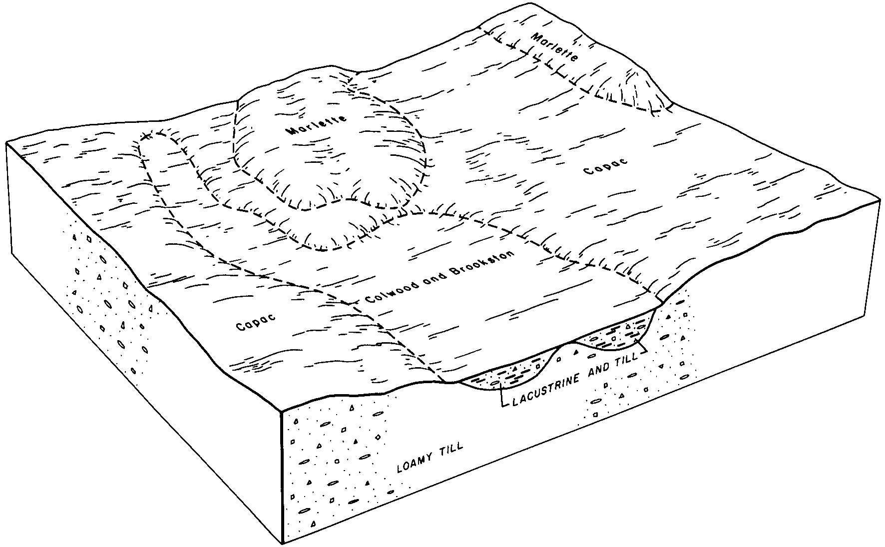
Colwood-Brookston loams | Co | 35443 | 186725 | 689d | mi065 | 1977 | 1:15840 |
Urban land-Capac-Colwood complex, 0 to 4 percent slopes | UpA | 11770 | 186762 | 68bl | mi065 | 1977 | 1:15840 |
Colwood loam | Cs | 1543 | 187930 | 69k8 | mi067 | 1965 | 1:15840 |
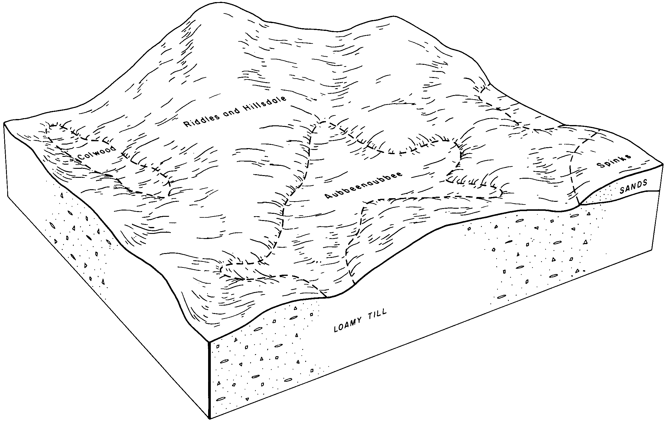
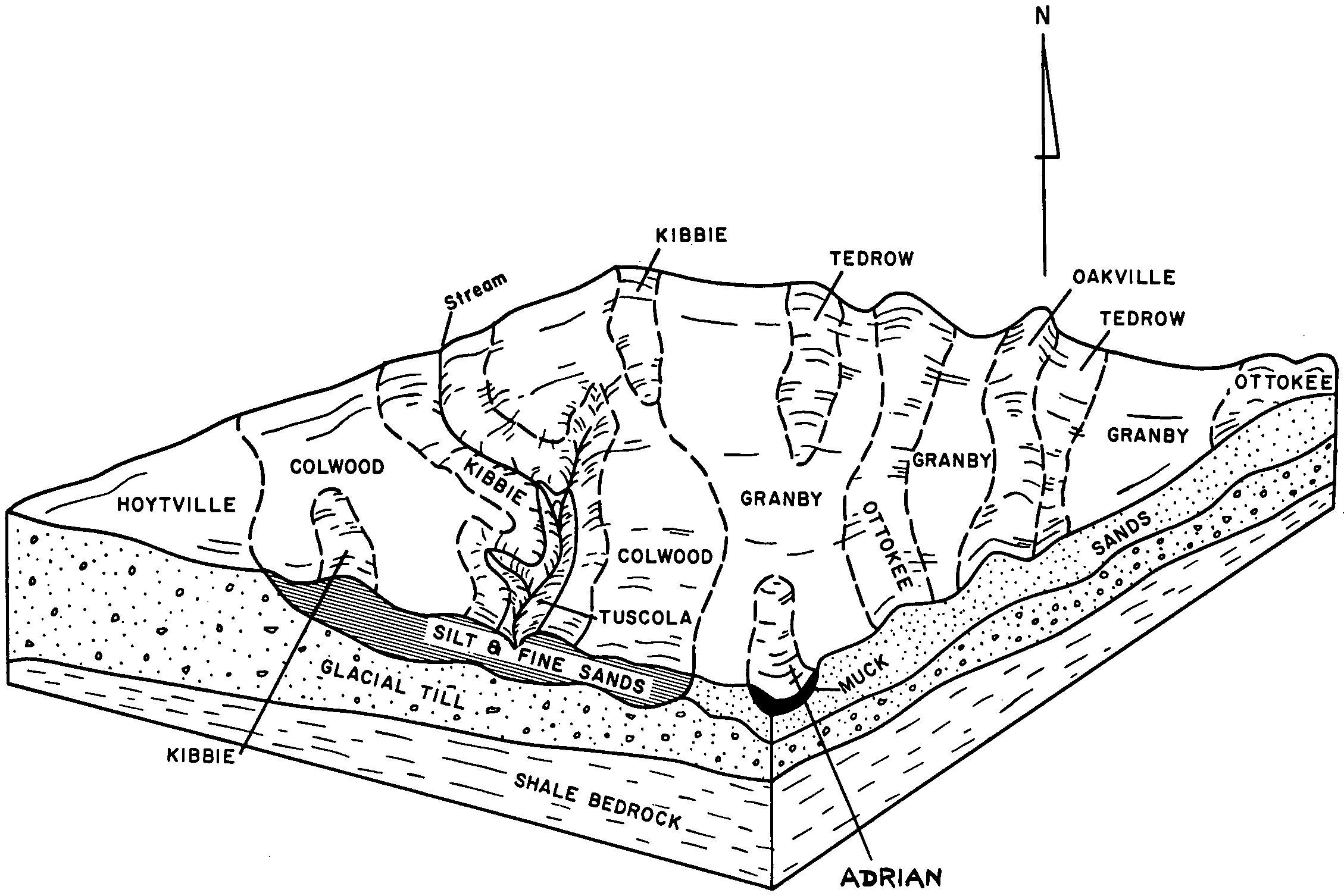
Gilford-Colwood complex | 18 | 20146 | 188757 | 6bdy | mi075 | 1979 | 1:15840 |
Colwood silt loam | 69 | 1023 | 187195 | 68sk | mi081 | 1984 | 1:15840 |
Colwood loam | Co | 4064 | 192011 | 6fsx | mi087 | 1966 | 1:15840 |
Brookston and Colwood loams | Bx | 50 | 2673664 | 6bgq | mi087 | 1966 | 1:15840 |
Colwood silt loam | Cp | 6 | 2409420 | 2lw67 | mi087 | 1966 | 1:15840 |
Colwood very fine sandy loam, 0 to 3 percent slopes | CeA | 4808 | 188455 | 6b36 | mi091 | 1957 | 1:20000 |
Colwood loam | Co | 3409 | 2508730 | 68tz | mi091 | 1957 | 1:20000 |
Colwood and Wauseon fine sandy loams, 0 to 3 percent slopes | CfA | 2731 | 188456 | 6b37 | mi091 | 1957 | 1:20000 |
Kibbie and Colwood fine sandy loams, 0 to 3 percent slopes | KeA | 896 | 188503 | 6b4r | mi091 | 1957 | 1:20000 |
Kibbie and Colwood fine sandy loams, 3 to 7 percent slopes | KeB | 153 | 188504 | 6b4s | mi091 | 1957 | 1:20000 |
Colwood fine sandy loam | Cr | 3532 | 187550 | 6950 | mi093 | 1968 | 1:20000 |
Colwood-Urban land complex, dense substratum, 0 to 2 percent slopes | ColucA | 15 | 3015239 | 2v14n | mi099 | 1967 | 1:20000 |
Colwood loam | 29 | 2546 | 187239 | 68tz | mi115 | 1980 | 1:15840 |
Kibbie and Colwood fine sandy loams, 0 to 3 percent slopes | 116A | 54 | 2509205 | 6b4r | mi115 | 1980 | 1:15840 |
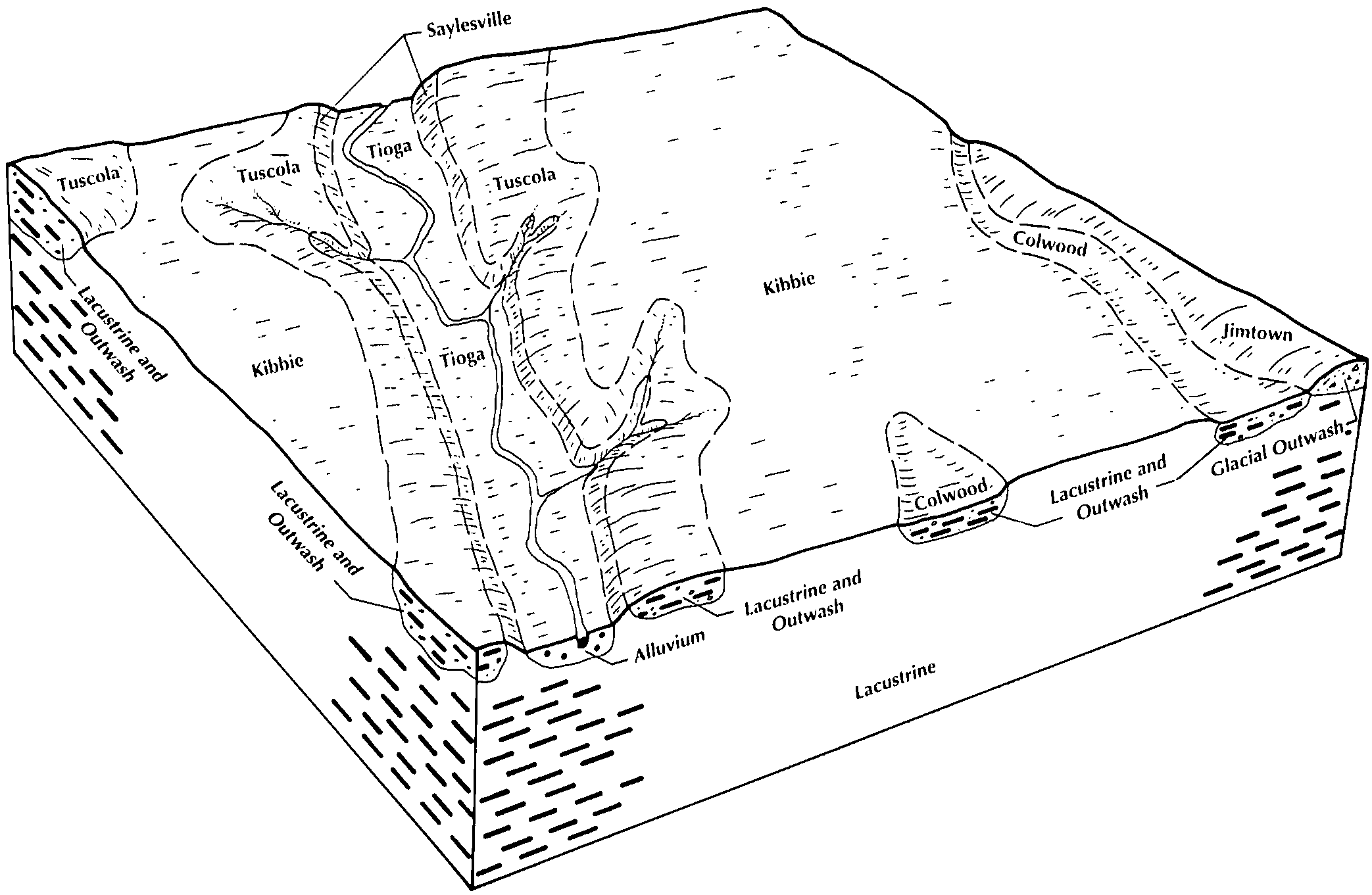
Lamson-Colwood complex | 107 | 21 | 2509166 | 6fdy | mi115 | 1980 | 1:15840 |
Brookston and Colwood loams | 12 | 9773 | 188812 | 6bgq | mi125 | 1980 | 1:15840 |
Colwood silt loam | 108 | 6 | 2423765 | 2mc3z | mi125 | 1980 | 1:15840 |
Colwood loam | 106 | 1 | 2423093 | 2mbf9 | mi145 | 1991 | 1:15840 |
Colwood loam | Co | 120 | 2508367 | 6fsx | mi147 | 1969 | 1:20000 |
Colwood loam | Cl | 1 | 2508257 | 6fsx | mi151 | 1955 | 1:15840 |
Colwood loam | Cs | 2943 | 187789 | 69dq | mi155 | 1967 | 1:12000 |
Colwood silt loam | Cp | 18 | 2398622 | 2lhyx | mi155 | 1967 | 1:12000 |
Colwood fine sandy loam | Cr | 1 | 2440115 | 2mx4d | mi155 | 1967 | 1:12000 |
Colwood loam | 145 | 20 | 2508147 | 6fsx | mi157 | 1984 | 1:15840 |
Colwood silt loam | 106 | 3 | 2423845 | 2mc6k | mi157 | 1984 | 1:15840 |
Colwood silt loam | 32 | 8892 | 186314 | 67w4 | mi159 | 1984 | 1:15840 |
Lamson-Colwood complex | Ln | 2875 | 191640 | 6fdy | mi161 | 1974 | 1:20000 |
Colwood-Urban land complex, 0 to 2 percent slopes | ColuaA | 3084 | 3015136 | 2tx79 | mi163 | 1974 | 1:12000 |
Kibbie-Urban land-Colwood complex, 0 to 4 percent slopes | KibucB | 3035 | 3015167 | 2v14g | mi163 | 1974 | 1:12000 |
Colwood-Urban land complex, 0 to 2 percent slopes, rarely flooded | ColubA | 1545 | 3015174 | 2v14q | mi163 | 1974 | 1:12000 |
Rapson-Urban land-Colwood complex, 0 to 4 percent slopes | RapucB | 1101 | 3015159 | 2v13y | mi163 | 1974 | 1:12000 |
Rapson-Urban land-Colwood complex, dense substratum, 0 to 4 percent slopes | RapudB | 885 | 3015137 | 2tx7b | mi163 | 1974 | 1:12000 |
Kibbie-Urban land-Colwood complex, dense substratum, 0 to 4 percent slopes | KibudB | 620 | 3015151 | 2tx87 | mi163 | 1974 | 1:12000 |
Colwood sandy loam, 0 to 2 percent slopes | ColhaA | 485 | 3015190 | 2whtj | mi163 | 1974 | 1:12000 |
Kibbie-Urban land-Colwood complex, sandy substratum, 0 to 4 percent slopes | KibueB | 406 | 3015169 | 2v14k | mi163 | 1974 | 1:12000 |
Colwood-Urban land complex, dense substratum, 0 to 2 percent slopes | ColucA | 314 | 3015172 | 2v14n | mi163 | 1974 | 1:12000 |
Rapson-Colwood sandy loams, 0 to 4 percent slopes | RaphcB | 232 | 3015212 | 2whv7 | mi163 | 1974 | 1:12000 |
Colwood sandy loam, dense substratum, 0 to 2 percent slopes | ColhcA | 192 | 3015192 | 2whtl | mi163 | 1974 | 1:12000 |
Rapson-Colwood sandy loams, dense substratum, 0 to 4 percent slopes | RaphdB | 136 | 3015213 | 2whv8 | mi163 | 1974 | 1:12000 |
Colwood sandy loam, 0 to 2 percent slopes, rarely flooded | ColhbA | 97 | 3015191 | 2whtk | mi163 | 1974 | 1:12000 |
Kibbie-Colwood sandy loams, dense substratum, 0 to 4 percent slopes | KibhdB | 82 | 3015199 | 2whtt | mi163 | 1974 | 1:12000 |
Kibbie-Colwood sandy loams, sandy substratum, 0 to 4 percent slopes | KibheB | 59 | 3015200 | 2whtv | mi163 | 1974 | 1:12000 |
Colwood silt loam, 0 to 2 percent slopes | ColaaA | 49 | 3015189 | 2whth | mi163 | 1974 | 1:12000 |
Kibbie-Colwood sandy loams, 0 to 4 percent slopes | KibhcB | 10 | 3015198 | 2whts | mi163 | 1974 | 1:12000 |
Colwood silt loam | Co | 970 | 168556 | 5nd9 | oh033 | 1975 | 1:15840 |
Colwood loam | Cm | 2379 | 168436 | 5n8f | oh039 | 1981 | 1:15840 |
Colwood loam, 0 to 1 percent slopes | CmA | 4383 | 172123 | 5s3c | oh043 | 1998 | 1:12000 |
Colwood silt loam, bedrock substratum, 0 to 1 percent slopes | CnA | 1430 | 172124 | 5s3d | oh043 | 1998 | 1:12000 |
Colwood loam | Cn | 5208 | 169075 | 5ny1 | oh051 | 1981 | 1:15840 |
Colwood loam, 0 to 1 percent slopes | CoA | 308 | 644378 | pmjd | oh063 | 1997 | 1:12000 |
Colwood loam | Co | 515 | 168927 | 5ns8 | oh065 | 1987 | 1:15840 |
Colwood loam | Cn | 2391 | 168977 | 5ntw | oh069 | 1968 | 1:15840 |
Colwood silt loam | Co | 501 | 168978 | 5ntx | oh069 | 1968 | 1:15840 |
Colwood fine sandy loam, 0 to 1 percent slopes | Ck | 20 | 1536633 | 1nkzt | oh069 | 1968 | 1:15840 |
Colwood loam, 0 to 1 percent slopes | Cm | 18 | 1536634 | 1nkzv | oh069 | 1968 | 1:15840 |
Colwood silt loam | Cm | 4299 | 167970 | 5msd | oh077 | 1988 | 1:15840 |
Colwood loam, 0 to 1 percent slopes | CpA | 6 | 1606008 | 1qx5q | oh077 | 1988 | 1:15840 |
Colwood loam | Co | 7484 | 169829 | 5pqc | oh095 | 1978 | 1:15840 |
Colwood-Urban land complex | Cp | 2057 | 169830 | 5pqd | oh095 | 1978 | 1:15840 |
Colwood loam | Co | 1896 | 170385 | 5q99 | oh123 | 1981 | 1:15840 |
Colwood loam | Cw | 311 | 170622 | 5qjy | oh137 | 1971 | 1:20000 |
Colwood loam, 0 to 1 percent slopes | CsA | 28 | 1529149 | 1nb6d | oh137 | 1971 | 1:20000 |
Colwood fine sandy loam | Co | 5950 | 169555 | 5pfj | oh143 | 1983 | 1:15840 |
Colwood silt loam | Co | 8227 | 169973 | 5pw0 | oh147 | 1978 | 1:15840 |
Colwood fine sandy loam | Cp | 376 | 1592186 | 1qfsv | oh147 | 1978 | 1:15840 |
Colwood silt loam | Cw | 189 | 168072 | 5mwp | oh161 | 1967 | 1:15840 |
Colwood silt loam | Cp | 444 | 168139 | 5myv | oh171 | 1975 | 1:15840 |
Colwood loam | Cn | 41 | 1414124 | 1jghx | oh171 | 1975 | 1:15840 |
Colwood fine sandy loam, 0 to 1 percent slopes | CcA | 2807 | 168216 | 5n1b | oh173 | 2000 | 1:12000 |
Colwood loam, 0 to 1 percent slopes | CdA | 1262 | 168217 | 5n1c | oh173 | 2000 | 1:12000 |
Colwood-Urban land complex, 0 to 1 percent slopes | CtA | 107 | 168309 | 5n4b | oh173 | 2000 | 1:12000 |
Colwood silt loam | Co | 1782 | 169604 | 5ph3 | oh175 | 1980 | 1:15840 |
Colwood fine sandy loam, 0 to 2 percent slopes | 7309A | 7727 | 423269 | 2tjxh | wi021 | 1972 | 1:15840 |
Colwood silt loam, 0 to 2 percent slopes | 7379A | 6936 | 753471 | 2tjx2 | wi025 | 1972 | 1:15840 |
Colwood silty clay loam, 0 to 2 percent slopes | 7579A | 1199 | 423562 | 2tjxk | wi027 | 1976 | 1:15840 |
Colwood silt loam, 0 to 2 percent slopes | 7379A | 310 | 425213 | 2tjx2 | wi045 | 1969 | 1:12000 |
Colwood silt loam, 0 to 2 percent slopes | 7379A | 4543 | 423670 | 2tjx2 | wi047 | 1974 | 1:20000 |
Colwood silt loam, 0 to 2 percent slopes | 7379A | 600 | 3268628 | 2tjx2 | wi059 | 2023 | 1:15840 |
Colwood fine sandy loam, 0 to 2 percent slopes | 7309A | 1913 | 426059 | 2tjxh | wi077 | 1969 | 1:20000 |
Colwood silt loam, 0 to 2 percent slopes | 7379A | 211 | 3403292 | 2tjx2 | wi079 | 2023 | 1:15840 |
Colwood silt loam, 0 to 2 percent slopes | 7379A | 1553 | 425958 | 2tjx2 | wi089 | 1967 | 1:15840 |
Colwood silt loam, 0 to 2 percent slopes | 7379A | 387 | 3268761 | 2tjx2 | wi101 | 2023 | 1:15840 |
Colwood silt loam, 0 to 2 percent slopes | 7379A | 5647 | 426282 | 2tjx2 | wi105 | 1970 | 1:20000 |
Colwood loam, 0 to 2 percent slopes | 7779A | 853 | 423135 | 2tjxj | wi111 | 1977 | 1:15840 |
Colwood silt loam, 0 to 2 percent slopes | 7379A | 2443 | 423868 | 2tjx2 | wi117 | 1974 | 1:15840 |
Colwood silt loam, 0 to 2 percent slopes | 7379A | 612 | 425607 | 2tjx2 | wi127 | 1967 | 1:15840 |
Colwood silt loam, 0 to 2 percent slopes | 7379A | 4443 | 425714 | 2tjx2 | wi131 | 1967 | 1:15840 |
Colwood silt loam, 0 to 2 percent slopes | 7379A | 1742 | 3403441 | 2tjx2 | wi133 | 2023 | 1:15840 |


