| Colp silt loam, 5 to 10 percent slopes, eroded, rarely flooded | 7122C2 | 153 | 602388 | n6tw | il003 | 2002 | 1:12000 |
Colp silt loam, 2 to 5 percent slopes, rarely flooded | 7122B | 10 | 609147 | nfvx | il003 | 2002 | 1:12000 |
Colp silt loam, 2 to 5 percent slopes | 122B | 490 | 1607450 | 2yp47 | il023 | 2006 | 1:12000 |
Colp silt loam, 10 to 18 percent slopes, eroded | 122D2 | 221 | 1607451 | 1qyp8 | il023 | 2006 | 1:12000 |
Colp silt loam, 2 to 5 percent slopes | 122B | 2558 | 806826 | 2yp47 | il055 | 2005 | 1:12000 |
Colp silty clay loam, 5 to 10 percent slopes, severely eroded | 122C3 | 863 | 806830 | w2ks | il055 | 2005 | 1:12000 |
Colp silty clay loam, 10 to 18 percent slopes, severely eroded | 122D3 | 307 | 806834 | w2kx | il055 | 2005 | 1:12000 |
Colp silt loam, 2 to 5 percent slopes, eroded | 122B2 | 94 | 806828 | w2kq | il055 | 2005 | 1:12000 |
Colp silt loam, 10 to 18 percent slopes, eroded, rarely flooded | 7122D2 | 159 | 714014 | ryzq | il069 | 2003 | 1:12000 |
Colp silt loam, 5 to 10 percent slopes, eroded, rarely flooded | 7122C2 | 140 | 714013 | ryzp | il069 | 2003 | 1:12000 |
Colp silty clay loam, 10 to 18 percent slopes, severely eroded | 122D3 | 5865 | 1537820 | 1nm73 | il077 | 2006 | 1:12000 |
Colp silt loam, 2 to 5 percent slopes | 122B | 2608 | 1537817 | 2yp47 | il077 | 2006 | 1:12000 |
Colp silty clay loam, 10 to 18 percent slopes, severely eroded, rarely flooded | 7122D3 | 2496 | 1540799 | 1nqb6 | il077 | 2006 | 1:12000 |
Colp silt loam, 2 to 5 percent slopes, eroded | 122B2 | 2082 | 1537818 | 1nm71 | il077 | 2006 | 1:12000 |
Colp silt loam, 2 to 5 percent slopes, eroded, rarely flooded | 7122B2 | 964 | 1540790 | 1nq9x | il077 | 2006 | 1:12000 |
Colp silt loam, 5 to 10 percent slopes, eroded | 122C2 | 635 | 1537819 | 1nm72 | il077 | 2006 | 1:12000 |
Colp silt loam, 10 to 18 percent slopes, rarely flooded | 7122D | 622 | 1540800 | 1nqb7 | il077 | 2006 | 1:12000 |
Colp silt loam, 10 to 18 percent slopes | 122D | 484 | 1538853 | 1nn9f | il077 | 2006 | 1:12000 |
Colp silt loam, 5 to 10 percent slopes, eroded, rarely flooded | 7122C2 | 420 | 1540798 | 1nqb5 | il077 | 2006 | 1:12000 |
Colp silt loam, 2 to 5 percent slopes, rarely flooded | 7122B | 400 | 1540797 | 1nqb4 | il077 | 2006 | 1:12000 |
Colp-Orthents-Urban land complex, 2 to 5 percent slopes, rarely flooded | 2122B | 382 | 200829 | 6qzc | il119 | 2001 | 1:12000 |
Colp silt loam, 2 to 5 percent slopes, rarely flooded | 7122B | 282 | 198904 | 6nz8 | il119 | 2001 | 1:12000 |
Colp silty clay loam, 5 to 10 percent slopes, severely eroded, rarely flooded | 7122C | 194 | 198905 | 6nz9 | il119 | 2001 | 1:12000 |
Redbud-Colp silty clay loams, 10 to 18 percent slopes, severely eroded | 907D3 | 780 | 184158 | 65ml | il133 | 1998 | 1:12000 |
Colp silty clay loam, 5 to 10 percent slopes, severely eroded, occasionally flooded | 8122C3 | 201 | 184131 | 65lq | il133 | 1998 | 1:12000 |
Colp silt loam, 2 to 5 percent slopes, occasionally flooded | 8122B | 124 | 184130 | 65lp | il133 | 1998 | 1:12000 |
Colp silt loam, 2 to 5 percent slopes, eroded, rarely flooded | 7122B2 | 1028 | 1405438 | 1j5gq | il145 | 2005 | 1:12000 |
Colp silt loam, 5 to 10 percent slopes, eroded, rarely flooded | 7122C2 | 335 | 608112 | ndsj | il151 | 2003 | 1:12000 |
Colp silt loam, 10 to 18 percent slopes, eroded, rarely flooded | 7122D2 | 214 | 608113 | ndsk | il151 | 2003 | 1:12000 |
Colp silt loam, 2 to 5 percent slopes, rarely flooded | 7122B | 19 | 608111 | ndsh | il151 | 2003 | 1:12000 |
Colp silt loam, 5 to 10 percent slopes, eroded, rarely flooded | 7122C2 | 157 | 748988 | t4cx | il153 | 2004 | 1:12000 |
Colp silt loam, 10 to 18 percent slopes, eroded, rarely flooded | 7122D2 | 39 | 748989 | t4cy | il153 | 2004 | 1:12000 |
Colp silt loam, 2 to 5 percent slopes, rarely flooded | 7122B | 17 | 748987 | t4cw | il153 | 2004 | 1:12000 |
Colp silty clay loam, 5 to 10 percent slopes, severely eroded | 122C3 | 1201 | 200469 | 6qlr | il157 | 2001 | 1:12000 |
Colp silt loam, 5 to 10 percent slopes, eroded | 122C2 | 1200 | 200468 | 6qlq | il157 | 2001 | 1:12000 |
Colp silt loam, 2 to 5 percent slopes | 122B | 775 | 200467 | 2yp47 | il157 | 2001 | 1:12000 |
Colp silty clay loam, 10 to 18 percent slopes, severely eroded, occasionally flooded | 8122D3 | 2068 | 183132 | 64kh | il163 | 1997 | 1:12000 |
Redbud-Colp silty clay loams, 10 to 18 percent slopes, severely eroded | 907D3 | 1047 | 183187 | 64m8 | il163 | 1997 | 1:12000 |
Colp silty clay loam, 5 to 10 percent slopes, severely eroded, occasionally flooded | 8122C3 | 344 | 183131 | 64kg | il163 | 1997 | 1:12000 |
Colp silt loam, 2 to 5 percent slopes | 122B | 4260 | 178854 | 2yp47 | il165 | 1974 | 1:15840 |
Colp silt loam, 2 to 5 percent slopes, eroded, rarely flooded | 7122B2 | 711 | 1528995 | 1nb1f | il189 | 2006 | 1:12000 |
Colp silty clay loam, 5 to 10 percent slopes, severely eroded | 122C3 | 1191 | 1478087 | 1lm27 | il199 | 2007 | 1:12000 |
Colp silt loam, 2 to 5 percent slopes, eroded | 122B2 | 1175 | 1478086 | 1lm26 | il199 | 2007 | 1:12000 |
Colp silt loam, 2 to 5 percent slopes | 122B | 1143 | 1478085 | 2yp47 | il199 | 2007 | 1:12000 |
Colp silt loam, 10 to 18 percent slopes, eroded | 122D2 | 495 | 1902868 | 21w2v | il199 | 2007 | 1:12000 |
Colp silty clay loam, 10 to 18 percent slopes, severely eroded | 122D3 | 329 | 1478088 | 1lm28 | il199 | 2007 | 1:12000 |
Colp silt loam, 5 to 10 percent slopes, eroded | 122C2 | 285 | 1902863 | 21w2p | il199 | 2007 | 1:12000 |
Colp silt loam, 18 to 35 percent slopes, eroded | 122F2 | 182 | 1478245 | 1lm7b | il199 | 2007 | 1:12000 |
Colp silt loam, 5 to 10 percent slopes, eroded, rarely flooded | 7122C2 | 108 | 1709576 | 1vcym | il199 | 2007 | 1:12000 |
Colp silt loam, 2 to 5 percent slopes, eroded, rarely flooded | 7122B2 | 100 | 1711405 | 1vfvm | il199 | 2007 | 1:12000 |
Colp silt loam, 18 to 35 percent slopes, eroded, rarely flooded | 7122F2 | 56 | 1903086 | 21w9w | il199 | 2007 | 1:12000 |
Colp silt loam, 2 to 5 percent slopes, rarely flooded | 7122B | 45 | 1709575 | 1vcyl | il199 | 2007 | 1:12000 |
Colp silty clay loam, 10 to 18 percent slopes, severely eroded, rarely flooded | 7122D3 | 40 | 1902865 | 21w2r | il199 | 2007 | 1:12000 |
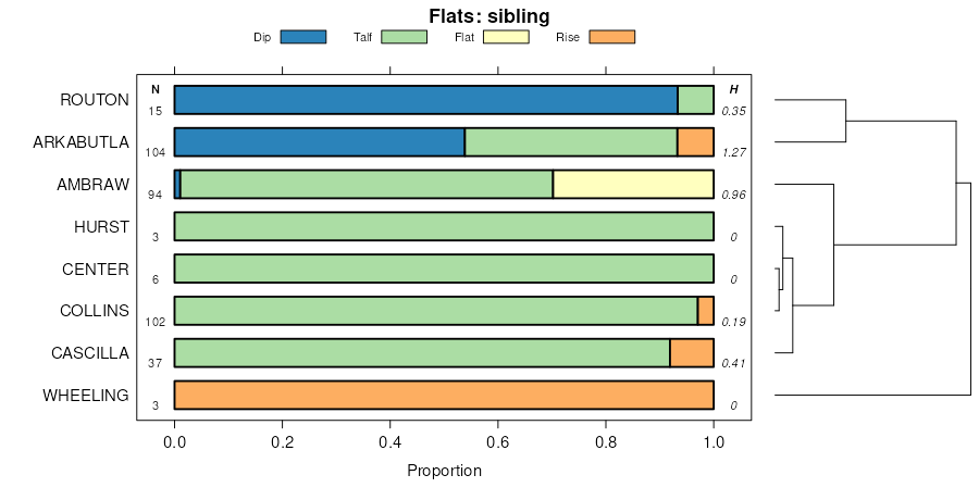
Cascilla-Colp-Wheeling complex, 2 to 25 percent slopes, occasionally flooded | CgD | 1371 | 1592771 | 1qgdq | ky602 | 1972 | 1:12000 |
Colp silt loam, 2 to 6 percent slopes, rarely flooded | CpB | 851 | 1597413 | 1qm7g | ky602 | 1972 | 1:12000 |
Colp silt loam, 6 to 12 percent slopes, eroded, rarely flooded | CpC2 | 832 | 1597414 | 1qm7h | ky602 | 1972 | 1:12000 |
Cascilla-Colp-Wheeling complex, 2 to 25 percent slopes, occasionally flooded | CgD | 793 | 2232216 | 2dxsz | ky610 | 1968 | 1:12000 |