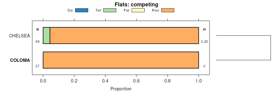
| Coloma loamy sand, 2 to 5 percent slopes, rarely flooded | 50B | 404 | 1689587 | 1tq4t | ia017 | 2008 | 1:12000 |
Coloma sand, 7 to 15 percent slopes | 689D | 3078 | 1887280 | 21bw0 | il011 | 2007 | 1:12000 |
Coloma sand, 1 to 7 percent slopes | 689B | 492 | 1887279 | 21bvz | il011 | 2007 | 1:12000 |
Coloma sand, 2 to 7 percent slopes | 689B | 486 | 796000 | vq9f | il015 | 2005 | 1:12000 |
Coloma sand, 20 to 30 percent slopes | 689F | 450 | 796003 | vq9j | il015 | 2005 | 1:12000 |
Coloma sand, 7 to 15 percent slopes | 689D | 113 | 1415774 | 1jj74 | il015 | 2005 | 1:12000 |
Coloma sand, 1 to 7 percent slopes | 689B | 12336 | 632708 | p7cy | il071 | 2005 | 1:12000 |
Coloma sand, 7 to 15 percent slopes | 689D | 3703 | 1412362 | 1jdp2 | il071 | 2005 | 1:12000 |
Coloma sand, 0 to 2 percent slopes | 689A | 1429 | 1480523 | 1lplt | il071 | 2005 | 1:12000 |
Coloma sand, 1 to 7 percent slopes | 689B | 2009 | 632791 | p7gm | il073 | 2001 | 1:12000 |
Coloma sand, 7 to 15 percent slopes | 689D | 612 | 632792 | p7gn | il073 | 2001 | 1:12000 |
Coloma sand, 20 to 30 percent slopes | 689F | 238 | 2023643 | 25xrt | il085 | 1990 | 1:12000 |
Coloma sand, 1 to 7 percent slopes | 689B | 7463 | 1145154 | 17fmg | il103 | 2004 | 1:12000 |
Coloma sand, 7 to 15 percent slopes | 689D | 3998 | 1145155 | 17fmh | il103 | 2004 | 1:12000 |
Coloma sand, 20 to 30 percent slopes | 689F | 379 | 1145156 | 17fmj | il103 | 2004 | 1:12000 |
Coloma sand, 1 to 7 percent slopes | 689B | 4439 | 245006 | 86yf | il131 | 2000 | 1:12000 |
Coloma sand, 7 to 15 percent slopes | 689D | 662 | 245007 | 86yg | il131 | 2000 | 1:12000 |
Coloma sand, 20 to 60 percent slopes | 689G | 470 | 245008 | 86yh | il131 | 2000 | 1:12000 |
Coloma sand, 7 to 15 percent slopes | 689D | 1123 | 1478959 | 1lmzc | il141 | 2005 | 1:12000 |
Coloma sand, 1 to 7 percent slopes | 689B | 703 | 1478958 | 1lmzb | il141 | 2005 | 1:12000 |
Coloma sand, 1 to 7 percent slopes | 689B | 274 | 632973 | p7nh | il161 | 2002 | 1:12000 |
Coloma sand, 7 to 15 percent slopes | 689D | 128 | 632972 | p7ng | il161 | 2002 | 1:12000 |
Coloma sand, 1 to 7 percent slopes | 689B | 1219 | 179423 | 60pv | il179 | 1991 | 1:15840 |
Coloma sand, 1 to 7 percent slopes | 689B | 2296 | 793678 | vmwj | il195 | 2003 | 1:12000 |
Coloma sand, 7 to 15 percent slopes | 689D | 710 | 793679 | vmwk | il195 | 2003 | 1:12000 |
Coloma sand, 1 to 7 percent slopes | 689B | 807 | 869245 | y5j5 | il203 | 2008 | 1:12000 |
Coloma sand, 7 to 15 percent slopes | 689D | 368 | 869246 | y5j6 | il203 | 2008 | 1:12000 |
Coloma loamy sand, 2 to 10 percent slopes | CtB | 697 | 165156 | 5jvm | in015 | 1987 | 1:15840 |
Coloma sand, 0 to 2 percent slopes | CnbA | 4585 | 165346 | 2w63w | in039 | 1997 | 1:12000 |
Coloma sand, 2 to 5 percent slopes | CnbB | 3946 | 165347 | 2w63y | in039 | 1997 | 1:12000 |
Coloma sand, 5 to 10 percent slopes | CnbC | 1945 | 165348 | 2w640 | in039 | 1997 | 1:12000 |
Coloma loamy sand, 6 to 15 percent slopes | CnaC | 306 | 242384 | 846v | in045 | 1999 | 1:12000 |
Coloma loamy sand, 2 to 6 percent slopes | CnaB | 288 | 242383 | 846t | in045 | 1999 | 1:12000 |
Coloma loamy sand, 0 to 6 percent slopes, fine-loamy minor components | ClB | 3290 | 160858 | 2w644 | in085 | 1985 | 1:20000 |
Coloma loamy sand, 6 to 12 percent slopes, fine-loamy minor components | ClC | 793 | 160859 | 2w646 | in085 | 1985 | 1:20000 |
Coloma sand, 2 to 5 percent slopes | CnbB | 3258 | 1702543 | 2w63y | in099 | 1978 | 1:15840 |
Coloma sand, 5 to 10 percent slopes | CnbC | 2321 | 1702544 | 2w640 | in099 | 1978 | 1:15840 |
Urban land-Coloma complex, 2 to 5 percent slopes | UfhB | 214 | 2485516 | 2pfcy | in099 | 1978 | 1:15840 |
Coloma sand, 0 to 2 percent slopes | CnbA | 124 | 2495703 | 2w63w | in099 | 1978 | 1:15840 |
Urban land-Coloma complex, 5 to 10 percent slopes | UfhC | 67 | 2485517 | 2pfcz | in099 | 1978 | 1:15840 |
Coloma sand, 2 to 5 percent slopes | CnbB | 6818 | 625115 | 2w63y | in141 | 2001 | 1:12000 |
Coloma sand, 5 to 10 percent slopes | CnbC | 1842 | 625114 | 2w640 | in141 | 2001 | 1:12000 |
Urban land-Coloma complex, 0 to 2 percent slopes | UfhA | 1539 | 625409 | nzsh | in141 | 2001 | 1:12000 |
Urban land-Coloma complex, 2 to 5 percent slopes | UfhB | 1521 | 627869 | p2bv | in141 | 2001 | 1:12000 |
Urban land-Coloma complex, 5 to 10 percent slopes | UfhC | 805 | 625408 | nzsg | in141 | 2001 | 1:12000 |
Coloma sand, 0 to 2 percent slopes | CnbA | 491 | 2481934 | 2w63w | in141 | 2001 | 1:12000 |
Coloma sand, 10 to 18 percent slopes | CnbD | 39 | 625113 | nzgy | in141 | 2001 | 1:12000 |
Coloma sand, 0 to 6 percent slopes, nonspodic minor components | ChB | 1312 | 162608 | 2w63v | in149 | 1980 | 1:15840 |
Coloma sand, 6 to 15 percent slopes | CrC | 350 | 163916 | 5hkm | in157 | 1990 | 1:15840 |
Coloma loamy sand, 0 to 6 percent slopes | 57B | 13773 | 186107 | 2w643 | mi015 | 1988 | 1:15840 |
Coloma loamy sand, 6 to 12 percent slopes | 57C | 9786 | 186108 | 2w645 | mi015 | 1988 | 1:15840 |
Coloma-Boyer loamy sands, 18 to 40 percent slopes | 58E | 7951 | 186114 | 67np | mi015 | 1988 | 1:15840 |
Coloma loamy sand, 12 to 18 percent slopes | 57D | 5969 | 186109 | 2w647 | mi015 | 1988 | 1:15840 |
Coloma-Boyer loamy sands, 0 to 6 percent slopes | 58B | 5867 | 186111 | 67nl | mi015 | 1988 | 1:15840 |
Coloma-Boyer loamy sands, 6 to 12 percent slopes | 58C | 4607 | 186112 | 67nm | mi015 | 1988 | 1:15840 |
Coloma-Boyer loamy sands, 12 to 18 percent slopes | 58D | 4584 | 186113 | 67nn | mi015 | 1988 | 1:15840 |
Coloma loamy sand, 18 to 40 percent slopes | 57E | 4576 | 186110 | 67nk | mi015 | 1988 | 1:15840 |
Coloma-Marlette complex, 18 to 40 percent slopes | 68E | 1829 | 186127 | 67p3 | mi015 | 1988 | 1:15840 |
Coloma-Marlette complex, 6 to 12 percent slopes | 68C | 1191 | 186125 | 67p1 | mi015 | 1988 | 1:15840 |
Coloma-Marlette complex, 12 to 18 percent slopes | 68D | 812 | 186126 | 67p2 | mi015 | 1988 | 1:15840 |
Coloma-Marlette complex, 0 to 6 percent slopes | 68B | 555 | 186124 | 67p0 | mi015 | 1988 | 1:15840 |
Coloma loamy sand, 0 to 6 percent slopes | 12B | 5880 | 188670 | 2w643 | mi025 | 1993 | 1:15840 |
Coloma loamy sand, 6 to 12 percent slopes | 12C | 3157 | 188671 | 2w645 | mi025 | 1993 | 1:15840 |
Coloma loamy sand, 12 to 18 percent slopes | 12D | 1701 | 188672 | 2w647 | mi025 | 1993 | 1:15840 |
Urban land-Coloma complex, 0 to 6 percent slopes | 113B | 1679 | 188668 | 6bb2 | mi025 | 1993 | 1:15840 |
Coloma loamy sand, 18 to 40 percent slopes | 12E | 1032 | 188673 | 6bb7 | mi025 | 1993 | 1:15840 |
Urban land-Coloma complex, 6 to 12 percent slopes | 113C | 428 | 188669 | 6bb3 | mi025 | 1993 | 1:15840 |
Coloma-Boyer loamy sands, 12 to 18 percent slopes | 90D | 250 | 188736 | 6bd8 | mi025 | 1993 | 1:15840 |
Coloma-Boyer loamy sands, 6 to 12 percent slopes | 90C | 208 | 188735 | 6bd7 | mi025 | 1993 | 1:15840 |
Coloma-Boyer loamy sands, 0 to 6 percent slopes | 90B | 178 | 188734 | 6bd6 | mi025 | 1993 | 1:15840 |
Coloma loamy sand, 0 to 6 percent slopes | 40B | 4094 | 186935 | 2w643 | mi027 | 1988 | 1:15840 |
Coloma loamy sand, 6 to 12 percent slopes | 40C | 2018 | 186936 | 2w645 | mi027 | 1988 | 1:15840 |
Coloma sand, 0 to 6 percent slopes | 50B | 5842 | 188661 | 6b9v | mi059 | 1991 | 1:15840 |
Coloma sand, 6 to 18 percent slopes | 50C | 4205 | 188662 | 6b9w | mi059 | 1991 | 1:15840 |
Coloma sand, 18 to 35 percent slopes | 50E | 805 | 188663 | 6b9x | mi059 | 1991 | 1:15840 |
Coloma loamy sand, 0 to 6 percent slopes | CnB | 1325 | 187921 | 2w643 | mi067 | 1965 | 1:15840 |
Coloma sand, 0 to 6 percent slopes | CoB | 1247 | 187925 | 2w63t | mi067 | 1965 | 1:15840 |
Coloma sand, 6 to 12 percent slopes | CoC2 | 482 | 187927 | 2w63z | mi067 | 1965 | 1:15840 |
Coloma loamy sand, 6 to 12 percent slopes | CnC2 | 223 | 187923 | 2w645 | mi067 | 1965 | 1:15840 |
Coloma sand, 0 to 6 percent slopes | 12B | 14764 | 186595 | 2w63t | mi073 | 1983 | 1:15840 |
Coloma sand, 6 to 12 percent slopes | 12C | 6118 | 186596 | 2w63z | mi073 | 1983 | 1:15840 |
Coloma sand, 18 to 35 percent slopes | 12E | 3596 | 186598 | 2w642 | mi073 | 1983 | 1:15840 |
Coloma sand, 12 to 18 percent slopes | 12D | 2555 | 186597 | 6858 | mi073 | 1983 | 1:15840 |
Woodbeck-Coloma complex, 1 to 6 percent slopes | 66B | 1209 | 186582 | 684s | mi073 | 1983 | 1:15840 |
Woodbeck-Coloma complex, 6 to 12 percent slopes | 66C | 548 | 186583 | 684t | mi073 | 1983 | 1:15840 |
Coloma loamy sand, 0 to 6 percent slopes | CoB | 9776 | 187058 | 2w643 | mi077 | 1978 | 1:15840 |
Coloma loamy sand, 6 to 12 percent slopes | CoC | 7736 | 187059 | 2w645 | mi077 | 1978 | 1:15840 |
Coloma loamy sand, 12 to 18 percent slopes | CoD | 5925 | 187060 | 2w647 | mi077 | 1978 | 1:15840 |
Spinks-Coloma loamy sands, 18 to 35 percent slopes | StE | 3032 | 187086 | 68p1 | mi077 | 1978 | 1:15840 |
Spinks-Coloma sands, 0 to 6 percent slopes | 47B | 7840 | 192562 | 2w648 | mi105 | 1992 | 1:15840 |
Spinks-Coloma sands, 6 to 12 percent slopes | 47C | 6037 | 192563 | 2w649 | mi105 | 1992 | 1:15840 |
Spinks-Coloma sands, 12 to 18 percent slopes | 47D | 3625 | 192564 | 6gcr | mi105 | 1992 | 1:15840 |
Spinks-Coloma sands, 18 to 40 percent slopes | 47E | 2496 | 192565 | 6gcs | mi105 | 1992 | 1:15840 |
Coloma sand, 0 to 6 percent slopes | 63B | 2035 | 192586 | 2w63t | mi105 | 1992 | 1:15840 |
Coloma-Scalley complex, 6 to 12 percent slopes | 94C | 889 | 192619 | 6gfj | mi105 | 1992 | 1:15840 |
Coloma-Scalley complex, 2 to 6 percent slopes | 94B | 778 | 192618 | 6gfh | mi105 | 1992 | 1:15840 |
Coloma sand, 6 to 12 percent slopes | 63C | 727 | 192587 | 2w63z | mi105 | 1992 | 1:15840 |
Coloma-Scalley complex, 12 to 18 percent slopes | 94D | 346 | 192620 | 6gfk | mi105 | 1992 | 1:15840 |
Coloma sand, 12 to 18 percent slopes | 63D | 226 | 192588 | 6gdj | mi105 | 1992 | 1:15840 |
Coloma sand, 18 to 35 percent slopes | 63E | 178 | 192589 | 2w642 | mi105 | 1992 | 1:15840 |
Coloma sand, 0 to 6 percent slopes | 11B | 44909 | 187705 | 2w63t | mi107 | 1982 | 1:15840 |
Coloma sand, 6 to 18 percent slopes | 11C | 36084 | 187706 | 2w641 | mi107 | 1982 | 1:15840 |
Coloma sand, 18 to 35 percent slopes | 11E | 3536 | 187707 | 2w642 | mi107 | 1982 | 1:15840 |
Coloma loamy sand, loamy substratum, 0 to 6 percent slopes | 45B | 1993 | 187750 | 69cg | mi107 | 1982 | 1:15840 |
Metea-Coloma loamy sand, 6 to 18 percent slopes | 50C | 1198 | 187759 | 69cr | mi107 | 1982 | 1:15840 |
Coloma-Brems-Fern complex, 0 to 6 percent slopes | ClmaaB | 2666 | 2763249 | 2tpkb | mi121 | 1966 | 1:15840 |
Coloma-Brems-Metea complex, 6 to 12 percent slopes | ClmaaC | 448 | 2763250 | 2tpkc | mi121 | 1966 | 1:15840 |
Coloma sand, 0 to 6 percent slopes | 29B | 28283 | 186461 | 2w63t | mi123 | 1990 | 1:15840 |
Coloma sand, 6 to 12 percent slopes | 29C | 27486 | 186462 | 2w63z | mi123 | 1990 | 1:15840 |
Spinks-Metea-Coloma complex, 6 to 12 percent slopes | 17C | 9169 | 186446 | 680d | mi123 | 1990 | 1:15840 |
Coloma sand, 12 to 30 percent slopes | 29D | 8872 | 186463 | 680y | mi123 | 1990 | 1:15840 |
Spinks-Metea-Coloma complex, 1 to 6 percent slopes | 17B | 5983 | 186445 | 680c | mi123 | 1990 | 1:15840 |
Grattan-Coloma complex, 0 to 6 percent slopes | 130B | 2125 | 186428 | 67zt | mi123 | 1990 | 1:15840 |
Grattan, banded substratum-Coloma complex, 6 to 18 percent slopes | 131C | 1604 | 186432 | 67zy | mi123 | 1990 | 1:15840 |
Grattan-Coloma complex, 6 to 18 percent slopes | 130C | 936 | 186429 | 67zv | mi123 | 1990 | 1:15840 |
Grattan, banded substratum-Coloma complex, 0 to 6 percent slopes | 131B | 607 | 186431 | 67zx | mi123 | 1990 | 1:15840 |
Grattan-Coloma complex, 18 to 30 percent slopes | 130E | 240 | 186430 | 67zw | mi123 | 1990 | 1:15840 |
Grattan, banded substratum-Coloma complex, 18 to 30 percent slopes | 131E | 167 | 186433 | 67zz | mi123 | 1990 | 1:15840 |
Coloma sand, 6 to 18 percent slopes | 60C | 4173 | 189068 | 2w641 | mi127 | 1992 | 1:15840 |
Coloma sand, 0 to 6 percent slopes | 60B | 2936 | 189067 | 2w63t | mi127 | 1992 | 1:15840 |
Coloma-Toogood complex, 0 to 6 percent slopes | 40B | 1285 | 189027 | 6bpn | mi127 | 1992 | 1:15840 |
Coloma sand, 18 to 35 percent slopes | 60E | 427 | 189069 | 2w642 | mi127 | 1992 | 1:15840 |
Coloma-Toogood complex, 0 to 6 percent slopes, lake moderated | 104B | 136 | 3223686 | 2zdht | mi127 | 1992 | 1:15840 |
Coloma-Toogood complex, 6 to 12 percent slopes | 40C | 123 | 189028 | 6bpp | mi127 | 1992 | 1:15840 |
Coloma-Toogood complex, 12 to 18 percent slopes | 40D | 104 | 189029 | 6bpq | mi127 | 1992 | 1:15840 |
Coloma sand, 0 to 6 percent slopes | ChB | 7437 | 190002 | 2w63t | mi133 | 1966 | 1:15840 |
Coloma sand, 6 to 12 percent slopes | ChC | 5605 | 190003 | 2w63z | mi133 | 1966 | 1:15840 |
Coloma sand, 18 to 35 percent slopes | ChE | 2694 | 190005 | 2w642 | mi133 | 1966 | 1:15840 |
Coloma loamy sand, 0 to 6 percent slopes | ChB | 8012 | 192651 | 2w643 | mi139 | 1967 | 1:15840 |
Coloma loamy sand, 6 to 12 percent slopes | ChC | 319 | 192652 | 2w645 | mi139 | 1967 | 1:15840 |
Coloma loamy sand, 0 to 6 percent slopes | 3B | 22873 | 186322 | 2w643 | mi159 | 1984 | 1:15840 |
Oshtemo-Coloma loamy sands, 12 to 18 percent slopes | 6D | 8839 | 186348 | 67x7 | mi159 | 1984 | 1:15840 |
Coloma loamy sand, 6 to 12 percent slopes | 3C | 8099 | 186323 | 2w645 | mi159 | 1984 | 1:15840 |
Oshtemo-Coloma loamy sands, 18 to 25 percent slopes | 6E | 3330 | 186349 | 67x8 | mi159 | 1984 | 1:15840 |
Urban land-Coloma complex, 0 to 6 percent slopes | 64B | 2121 | 186343 | 67x2 | mi159 | 1984 | 1:15840 |
Coloma sand, 0 to 6 percent slopes | 29B | 86963 | 190763 | 2w63t | mi600 | 1983 | 1:15840 |
Coloma sand, 6 to 18 percent slopes | 29D | 15445 | 190764 | 2w641 | mi600 | 1983 | 1:15840 |
Coloma sand, 0 to 6 percent slopes | 63B | 12358 | 193275 | 2w63t | mi614 | 2005 | 1:12000 |
Spinks-Coloma sands, 6 to 12 percent slopes | 47C | 12201 | 193256 | 2w649 | mi614 | 2005 | 1:12000 |
Spinks-Coloma sands, 0 to 6 percent slopes | 47B | 11869 | 193255 | 2w648 | mi614 | 2005 | 1:12000 |
Coloma-Tatches complex, 0 to 6 percent slopes | 21B | 6638 | 680941 | qvkv | mi614 | 2005 | 1:12000 |
Spinks-Coloma sands, 12 to 18 percent slopes | 47D | 5194 | 193257 | 6h33 | mi614 | 2005 | 1:12000 |
Coloma sand, 6 to 12 percent slopes | 63C | 3988 | 193276 | 2w63z | mi614 | 2005 | 1:12000 |
Spinks-Coloma sands, 18 to 35 percent slopes | 47E | 3935 | 193258 | 6h34 | mi614 | 2005 | 1:12000 |
Coloma sand, 12 to 18 percent slopes | 63D | 1409 | 193172 | 6h0c | mi614 | 2005 | 1:12000 |
Coloma sand, 18 to 35 percent slopes | 63E | 1146 | 193171 | 2w642 | mi614 | 2005 | 1:12000 |
Spinks-Coloma sands, 35 to 70 percent slopes | 47F | 805 | 193349 | 6h62 | mi614 | 2005 | 1:12000 |
Coloma sand, 35 to 70 percent slopes | 63F | 490 | 899711 | z66y | mi614 | 2005 | 1:12000 |
Coloma loamy sand, 0 to 6 percent slopes | N625B | 402 | 1690456 | 1tr1v | mn049 | 2007 | 1:12000 |
Coloma sand, 2 to 6 percent slopes | 7689B | 29061 | 422929 | g62w | wi001 | 1978 | 1:20000 |
Coloma sand, 6 to 12 percent slopes | 7689C | 8572 | 422930 | g62x | wi001 | 1978 | 1:20000 |
Coloma sand, 12 to 25 percent slopes | 7689D | 5751 | 422931 | g62y | wi001 | 1978 | 1:20000 |
Coloma loamy sand, 6 to 12 percent slopes | 7689C | 8272 | 426510 | 2t053 | wi097 | 1972 | 1:20000 |
Coloma loamy sand, 2 to 6 percent slopes | 7689B | 5048 | 426509 | 2vcmj | wi097 | 1972 | 1:20000 |
Coloma loamy sand, 6 to 12 percent slopes | 7689C | 8381 | 423954 | 2t053 | wi137 | 1986 | 1:20000 |
Coloma loamy sand, 2 to 6 percent slopes | 7689B | 5678 | 423953 | 2vcmj | wi137 | 1986 | 1:20000 |
Coloma loamy sand, 12 to 30 percent slopes | 7689E | 3657 | 423955 | g74z | wi137 | 1986 | 1:20000 |

