| Collins silt loam, 0 to 1 percent slopes, occasionally flooded, brief duration | 20 | 20336 | 564052 | 2t23j | ar021 | 1975 | 1:20000 |
Collins silt loam | Co | 10295 | 565298 | lz7f | ar025 | 1965 | 1:15840 |
Collins silt loam, 0 to 1 percent slopes, occasionally flooded, brief duration | 11 | 22200 | 564117 | 2t23j | ar031 | 1976 | 1:20000 |
Collins silt loam | Co | 6390 | 564380 | ly8t | ar037 | 1966 | 1:20000 |
Collins silt loam, 0 to 1 percent slopes, occasionally flooded, brief duration | Co | 8906 | 564267 | 2t23j | ar111 | 1973 | 1:20000 |
Collins silt loam | Co | 1110 | 564438 | lybp | ar123 | 1964 | 1:20000 |
Collins silt loam, 0 to 2 percent slopes, occasionally flooded, very brief duration | Cg | 574 | 654156 | 2t23m | ky075 | 2002 | 1:12000 |
Collins silt loam, 0 to 2 percent slopes, occasionally flooded, very brief duration | Cn | 39385 | 570623 | 2t23m | ky083 | 1995 | 1:12000 |
Collins silt loam, frequently flooded | Co | 10978 | 570624 | m4s7 | ky083 | 1995 | 1:12000 |
Collins-Iuka complex, occasionally flooded | Cu | 7111 | 570625 | m4s8 | ky083 | 1995 | 1:12000 |
Falaya-Collins complex, 0 to 2 percent slopes, occasionally flooded | Fa | 23898 | 1597328 | 1qm4q | ky602 | 1972 | 1:12000 |
Falaya-Collins complex, 0 to 2 percent slopes, frequently flooded | Fc | 3000 | 1597336 | 1qm4z | ky602 | 1972 | 1:12000 |
Collins-Iuka complex, 0 to 4 percent slopes, rarely flooded | Co | 870 | 1597332 | 1qm4v | ky602 | 1972 | 1:12000 |
Collins-Iuka complex, 0 to 2 percent slopes, occasionally flooded | Cu | 14890 | 2232232 | 2dxth | ky610 | 1968 | 1:12000 |
Collins-Iuka complex, 0 to 2 percent slopes, frequently flooded | Ci | 8074 | 2232333 | 2dxxr | ky610 | 1968 | 1:12000 |
Collins silt loam, 0 to 2 percent slopes, frequently flooded | Co | 451 | 2232334 | 2dxxs | ky610 | 1968 | 1:12000 |
Collins silt loam, 0 to 1 percent slopes, frequently flooded | 86117 | 9 | 2607649 | 2r02f | mo023 | 1982 | 1:24000 |
Collins silt loam, 0 to 3 percent slopes, rarely flooded | 90602 | 920 | 2689857 | 2r03t | mo069 | 1977 | 1:24000 |
Collins silt loam, 0 to 1 percent slopes, rarely flooded | 96001 | 431 | 2497727 | 2pqqj | mo069 | 1977 | 1:24000 |
Collins silt loam, 0 to 1 percent slopes, frequently flooded | 86117 | 324 | 2571567 | 2r02f | mo069 | 1977 | 1:24000 |
Collins silt loam, 0 to 3 percent slopes | 90316 | 151 | 2689856 | 2q2fs | mo069 | 1977 | 1:24000 |
Collins silt loam, 0 to 1 percent slopes, occasionally flooded, brief duration | 96000 | 1848 | 894073 | 2t23j | mo207 | 1983 | 1:24000 |
Collins silt loam, 0 to 3 percent slopes | 90316 | 529 | 2503528 | 2q2fs | mo207 | 1983 | 1:24000 |
Collins silt loam, 0 to 1 percent slopes, frequently flooded | 86117 | 269 | 2571552 | 2r02f | mo207 | 1983 | 1:24000 |
Collins silt loam | Co | 6785 | 567403 | m1fb | ms001 | 1966 | 1:15840 |
Collins silt loam | Co | 3206 | 567439 | m1gh | ms005 | 1971 | 1:20000 |
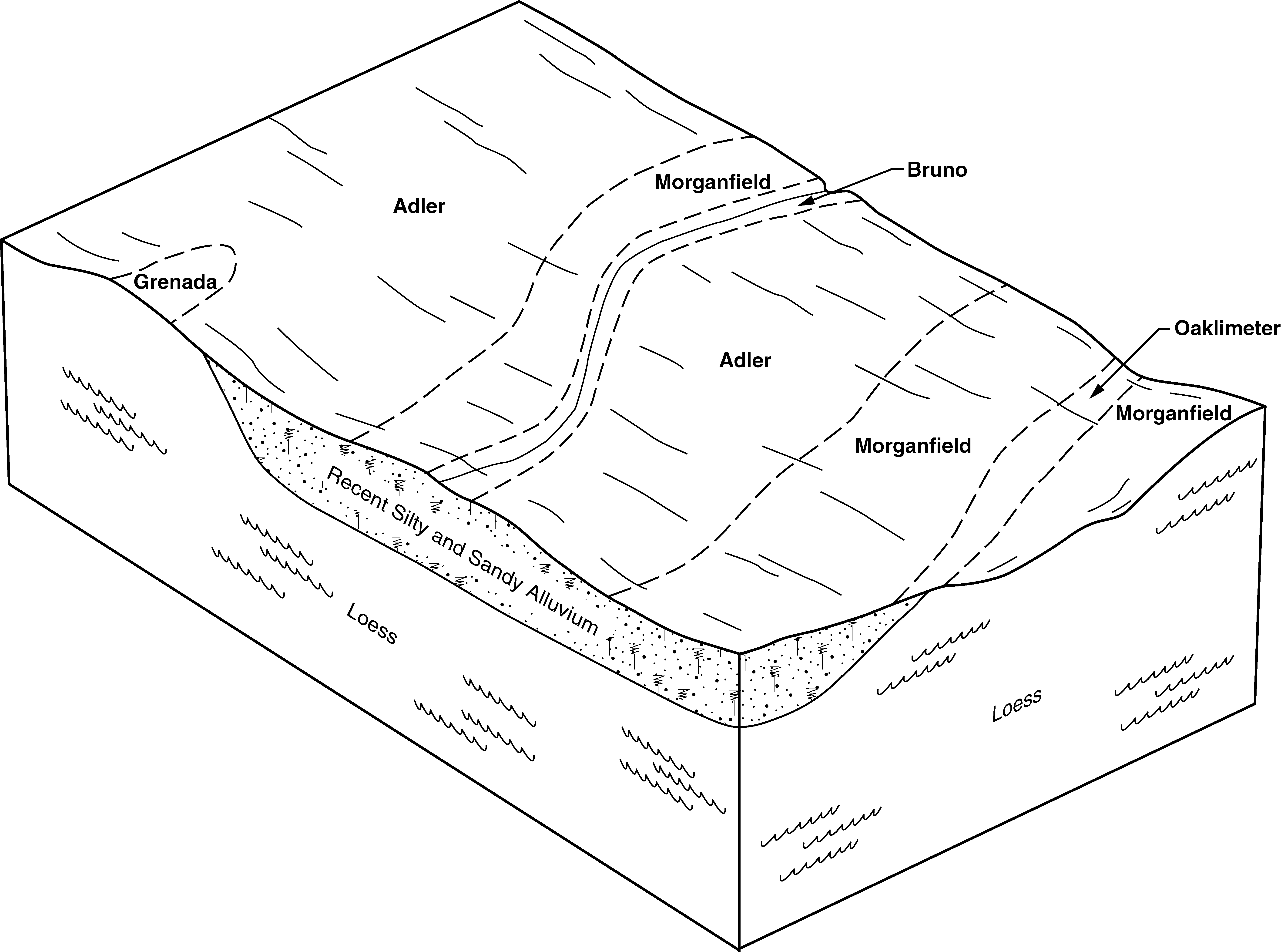
Collins silt loam (oaklimeter) | Co | 13064 | 331828 | c494 | ms013 | 1963 | 1:15840 |
Collins silt loam, local alluvium (oaklimeter) | Cm | 2558 | 331827 | c493 | ms013 | 1963 | 1:15840 |
Collins silt loam | Cn | 17403 | 567576 | m1lx | ms021 | 1961 | 1:20000 |
Collins silt loam (adler) | Cg | 33471 | 567725 | m1rq | ms033 | 1955 | 1:24000 |
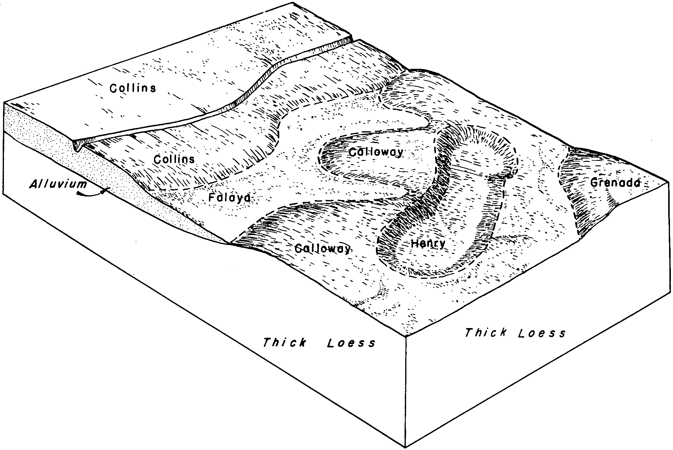
Collins and Falaya silt loams, local alluvium phases | Cl | 28816 | 567728 | m1rt | ms033 | 1955 | 1:24000 |
Vicksburg and Collins silt loams, local alluvium phases | Vb | 4503 | 567795 | m1tz | ms033 | 1955 | 1:24000 |
Collins silty clay loam (adler) | Ch | 1276 | 567726 | m1rr | ms033 | 1955 | 1:24000 |
Collins loamy sand, overwash phase (nugent) | Cf | 1046 | 567724 | m1rp | ms033 | 1955 | 1:24000 |
Collins silty clay loam, shallow phase (adler) | Ck | 542 | 567727 | m1rs | ms033 | 1955 | 1:24000 |
Collins silt loam, occasionally flooded | 11 | 1802 | 567798 | m1v2 | ms037 | 1992 | 1:20000 |
Collins silt loam | Cm | 12015 | 567839 | m1wd | ms043 | 1965 | 1:15840 |
Falaya-Collins association | Fc | 9282 | 567847 | m1wn | ms043 | 1965 | 1:15840 |
Collins silt loam, local alluvium | Cn | 1334 | 567840 | m1wf | ms043 | 1965 | 1:15840 |
Collins silt loam, occasionally flooded | Cn | 39444 | 1713061 | 1vhl1 | ms051 | 1997 | 1:20000 |
Collins and Silverdale soils, frequently flooded | CS | 4407 | 1713063 | 1vhl3 | ms051 | 1997 | 1:20000 |
Collins silt loam, 0 to 2 percent slopes | Co | 33 | 1884365 | 217tz | ms051 | 1997 | 1:20000 |
Collins silt loam | Ca | 9464 | 568072 | m23x | ms063 | 1976 | 1:20000 |
Collins silt loam, 0 to 2 percent slopes | 1 | 2984 | 568127 | m25p | ms083 | 1997 | 1:24000 |
Collins silt loam, 0 to 2 percent slopes, occasionally flooded | 2 | 307 | 568128 | m25q | ms083 | 1997 | 1:24000 |
Collins silt loam (vicksburg) | Co | 4587 | 568146 | m269 | ms085 | 1961 | 1:20000 |
Collins and Iuka soils | Cs | 4139 | 568147 | m26b | ms085 | 1961 | 1:20000 |
Collins-Arkabutla-Falaya association | CR | 10839 | 568264 | m2b3 | ms093 | 1968 | 1:20000 |
Collins silt loam, 0 to 2 percent slopes, frequently flooded, brief duration | Co | 4643 | 568270 | 2t23k | ms093 | 1968 | 1:20000 |
Collins-Arkabutla-Bruno association | CN | 4019 | 568263 | m2b2 | ms093 | 1968 | 1:20000 |
Collins silt loam | Cm | 19317 | 333240 | c5rp | ms097 | 1971 | 1:20000 |
Collins silt loam (occasionally flooded) | Cm | 49109 | 568309 | m2ck | ms107 | 1961 | 1:24000 |
Collins silt loam, local alluvium (occasionally flooded) | Co | 21982 | 568310 | m2cl | ms107 | 1961 | 1:24000 |
Mixed alluvial land (bruno and Collins soils, frequently flooded) | Mx | 14721 | 568344 | m2dp | ms107 | 1961 | 1:24000 |
Collins silt loam | Co | 4744 | 333639 | c65k | ms113 | 1965 | 1:15840 |
Collins silt loam, local alluvium | Cl | 4710 | 333638 | c65j | ms113 | 1965 | 1:15840 |
Collins silt loam, 0 to 2 percent slopes, occasionally flooded, brief duration | Ch | 3128 | 568369 | 2t23l | ms119 | 1956 | 1:24000 |
Collins silty clay loam (arkabutla) | Ck | 1800 | 568370 | m2fj | ms119 | 1956 | 1:24000 |
Collins soils and Waverly soils, local alluvium phases | Co | 1623 | 568373 | m2fm | ms119 | 1956 | 1:24000 |
Collins-Falaya silt loams, nearly level phases (collins, waverly) | Cm | 272 | 568371 | m2fk | ms119 | 1956 | 1:24000 |
Collins-Falaya silt loams, gently sloping phases (collins, waverly) | Cn | 222 | 568372 | m2fl | ms119 | 1956 | 1:24000 |
Collins silt loam | Cn | 22200 | 568510 | m2l1 | ms135 | 1966 | 1:24000 |
Collins silt loam, clayey subsoil variant | Co | 493 | 568511 | m2l2 | ms135 | 1966 | 1:24000 |
Collins silt loam | Cm | 30912 | 568564 | m2ms | ms137 | 1964 | 1:15840 |
Collins silt loam, local alluvium, 0 to 2 percent slopes, occasionally flooded, brief duration | Co | 18198 | 568565 | 2t23n | ms137 | 1964 | 1:15840 |
Collins silt loam (oaklimeter) | Cn | 2453 | 334178 | c6qy | ms139 | 1963 | 1:15840 |
Collins silt loam, local alluvium (oaklimeter) | Co | 517 | 334179 | c6qz | ms139 | 1963 | 1:15840 |
Collins silt loam (oaklimeter) | Co | 614 | 334305 | c6w1 | ms147 | 1965 | 1:20000 |
Collins silt loam, local alluvium | Cm | 678 | 568679 | m2rh | ms149 | 1962 | 1:15840 |
Collins silt loam | Ci | 644 | 568678 | m2rg | ms149 | 1962 | 1:15840 |
Collins silt loam, rarely flooded | 6 | 7160 | 571061 | m57b | ms157 | 2006 | 1:24000 |
Collins silt loam, occasionally flooded | Cn | 20344 | 334644 | c76z | ms161 | 1975 | 1:20000 |
Collins silt loam, frequently flooded | Co | 1487 | 334645 | c770 | ms161 | 1975 | 1:20000 |
Collins silt loam, 0 to 2 percent slopes, occasionally flooded, brief duration | Co | 27888 | 327169 | 2t23l | tn017 | 1980 | 1:15840 |
Collins silt loam, 0 to 2 percent slopes, occasionally flooded, brief duration | Co | 25175 | 3116367 | 2t23l | tn033 | 1985 | 1:24000 |
Collins silt loam, 0 to 2 percent slopes, frequently flooded, brief duration | Cl | 3648 | 566773 | 2t23k | tn045 | 1963 | 1:15840 |
Collins silt loam, 0 to 2 percent slopes, occasionally flooded, brief duration | Co | 16858 | 566966 | 2t23l | tn047 | 1961 | 1:15840 |
Collins silt loam, local alluvium, 0 to 2 percent slopes, occasionally flooded, brief duration | Cu | 13976 | 566967 | 2t23n | tn047 | 1961 | 1:15840 |
Collins fine sandy loam | Cf | 6809 | 566964 | m0z5 | tn047 | 1961 | 1:15840 |
Collins fine sandy loam, local alluvium | Cm | 5393 | 566965 | m0z6 | tn047 | 1961 | 1:15840 |
Collins silt loam, 0 to 2 percent slopes, occasionally flooded, brief duration | Co | 37914 | 567041 | 2t23l | tn053 | 1990 | 1:24000 |
Collins silt loam, 0 to 2 percent slopes, occasionally flooded, brief duration | Co | 7174 | 3116426 | 2t23l | tn075 | 1990 | 1:24000 |
Hymon silt loam, local alluvium phase (Collins) | He | 6577 | 327750 | c01l | tn077 | 1955 | 1:20000 |
Hymon silt loam (Collins) | Hd | 504 | 327749 | c01k | tn077 | 1955 | 1:20000 |
Collins silt loam, 0 to 2 percent slopes, frequently flooded, brief duration | Cs | 25878 | 567193 | 2t23k | tn113 | 1974 | 1:20000 |
Collins silt loam, 0 to 2 percent slopes, occasionally flooded, brief duration | Cl | 6019 | 3116424 | 2t23l | tn131 | 1966 | 1:15840 |
Collins silt loam, 0 to 2 percent slopes, occasionally flooded, brief duration | Co | 3681 | 567284 | 2t23l | tn157 | 1966 | 1:15840 |
Collins silt loam, 0 to 2 percent slopes, occasionally flooded, brief duration | Co | 28441 | 567368 | 2t23l | tn183 | 1986 | 1:24000 |
Collins silt loam, rarely flooded | Cn | 4674 | 567367 | m1d5 | tn183 | 1986 | 1:24000 |