| Floridana, Chobee, and Felda soils, frequently flooded | 24 | 13540 | 1473310 | 1lg34 | fl009 | 1990 | 1:24000 |
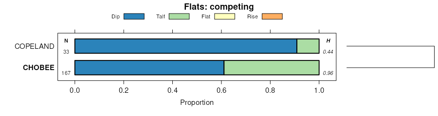
Chobee sandy loam, frequently flooded | 12 | 4339 | 1473298 | 1lg2r | fl009 | 1990 | 1:24000 |
Chobee mucky loamy fine sand, depressional | 13 | 1195 | 1473299 | 1lg2s | fl009 | 1990 | 1:24000 |
Chobee muck, frequently ponded, 0 to 1 percent slopes | 78 | 5082 | 1453485 | 2tzwf | fl015 | 1982 | 1:20000 |
Bradenton-Felda-Chobee complex, frequently flooded | 8 | 9020 | 1386902 | 1hk5s | fl027 | 1986 | 1:24000 |
Bradenton-Felda-Chobee complex, occasionally flooded | 7 | 6630 | 1386901 | 1hk5r | fl027 | 1986 | 1:24000 |
Chobee muck, frequently ponded, 0 to 1 percent slopes | 10 | 1170 | 1386904 | 2tzwf | fl027 | 1986 | 1:24000 |
Favoretta, Chobee, and Winder soils, frequently flooded | 7 | 15400 | 1529449 | 1nbj2 | fl035 | 1991 | 1:15840 |
Chobee loamy fine sand, frequently ponded, 0 to 1 percent slopes | 12 | 4710 | 1453571 | 2sm4w | fl043 | 1991 | 1:24000 |
Bradenton-Felda-Chobee association, frequently flooded | 27 | 40810 | 1384405 | 1hgl7 | fl049 | 1981 | 1:20000 |
Chobee fine sandy loam, frequently ponded, 0 to 1 percent slopes | 57 | 18940 | 1151443 | 2tzvw | fl051 | 1986 | 1:24000 |
Chobee fine sandy loam, limestone substratum, depressional | 34 | 10050 | 1151431 | 17n4y | fl051 | 1986 | 1:24000 |
Chobee fine sandy loam, frequently ponded, 0 to 1 percent slopes | 25 | 4557 | 1413525 | 2tzvw | fl055 | 1982 | 1:24000 |
Chobee sandy loam, frequently flooded | 12 | 12760 | 1406961 | 1j71v | fl057 | 1986 | 1:20000 |
Chobee loamy fine sand, frequently ponded, 0 to 1 percent slopes | 10 | 1425 | 1406959 | 2sm4w | fl057 | 1986 | 1:20000 |
Chobee muck, frequently ponded, 0 to 1 percent slopes | 11 | 815 | 1406960 | 2tzwf | fl057 | 1986 | 1:20000 |
Chobee loamy fine sand, frequently ponded, 0 to 1 percent slopes | 2 | 2114 | 756727 | 2sm4w | fl061 | 1984 | 1:20000 |
Chobee mucky loamy fine sand, depressional | 62 | 424 | 756782 | tdhb | fl061 | 1984 | 1:20000 |
Chobee muck, limestone substratum, frequently flooded | 46 | 11300 | 1414089 | 1jggs | fl075 | 1990 | 1:24000 |
Chobee-Gator complex, frequently flooded | 16 | 7720 | 1414060 | 1jgfv | fl075 | 1990 | 1:24000 |
Chobee-Bradenton complex, frequently flooded | 29 | 6040 | 1414072 | 1jgg7 | fl075 | 1990 | 1:24000 |
Chobee loamy fine sand, frequently ponded, 0 to 1 percent slopes | 13 | 3326 | 1384080 | 2sm4w | fl081 | 1981 | 1:24000 |
Parkwood variant-Chobee, limestone substratum-Parkwood complex | 39 | 1989 | 1384108 | 1hg8n | fl081 | 1981 | 1:24000 |
Chobee variant sandy clay loam | 14 | 589 | 1384081 | 1hg7s | fl081 | 1981 | 1:24000 |
Chobee muck, frequently ponded, 0 to 1 percent slopes | 57 | 6594 | 1421605 | 2tzwg | fl085 | 1979 | 1:20000 |
Floridana and Chobee soils, frequently flooded | 11 | 16264 | 323123 | bv7b | fl095 | 1986 | 1:20000 |
Chobee fine sandy loam, frequently flooded | 10 | 1246 | 323122 | bv79 | fl095 | 1986 | 1:20000 |
Chobee soils, frequently flooded | 39 | 30470 | 323208 | bvb2 | fl101 | 1980 | 1:20000 |
Chobee fine sandy loam, frequently flooded | 80 | 4004 | 1425063 | 1jtws | fl105 | 1987 | 1:20000 |
Bradenton-Felda-Chobee association, frequently flooded | 72 | 3671 | 1425056 | 1jtwk | fl105 | 1987 | 1:20000 |
Chobee fine sandy loam, frequently ponded, 0 to 1 percent slopes | 48 | 2415 | 1425037 | 2tzvw | fl105 | 1987 | 1:20000 |
Chobee loamy sand, frequently ponded, 0 to 1 percent slopes | 11 | 9618 | 1421168 | 2tzwd | fl111 | 1990 | 1:24000 |
Chobee loamy fine sand, frequently flooded | 68 | 850 | 323678 | bvt7 | fl119 | 1985 | 1:24000 |
Chobee fine sandy loam | 14 | 5190 | 1544114 | 1nts4 | fl127 | 1977 | 1:20000 |
Chobee fine sandy loam, frequently ponded, 0 to 1 percent slopes | 12 | 1680 | 3045930 | 2tzvw | fl611 | 1994 | 1:20000 |
Chobee sandy loam, depressional | 34 | 95 | 1585776 | 1q742 | fl616 | 1993 | 1:15840 |
Chobee muck, limestone substratum, depressional | 3 | 2252 | 1912457 | 22625 | fl618 | 2007 | 1:15840 |
Winder, Riviera, limestone substratum, and Chobee soils, frequently ponded, 0 to 1 percent slopes | 43 | 30275 | 3102973 | 2y9fz | fl621 | 1989 | 1:24000 |
Chobee, Winder, Gator soils, frequently ponded, 0 to 1 percent slopes | 22 | 12592 | 3102955 | 2y9fd | fl621 | 1989 | 1:24000 |
Chobee, limestone substratum-Dania, frequently ponded, association, 0 to 1 percent slopes | 4 | 626 | 3045923 | 2y0j4 | fl621 | 1989 | 1:24000 |
Chobee, limestone substratum-Dania, ponded-Urban land association, 0 to 1 percent slopes | 105 | 514 | 3045905 | 2y0j3 | fl621 | 1989 | 1:24000 |
Chobee, Winder, Gator soils, ponded-Urban land complex, 0 to 1 percent slopes | 106 | 448 | 3102956 | 2y9ff | fl621 | 1989 | 1:24000 |
Winder, Riviera, limestone substratum, and Chobee soils, ponded-Urban land complex, 0 to 1 percent slopes | 136 | 25 | 3102974 | 2y9g0 | fl621 | 1989 | 1:24000 |