| Chippewa silt loam, 0 to 8 percent slopes, extremely stony | ChwBc | 569 | 623089 | nxcn | nj037 | 2002 | 1:24000 |
Chippewa silt loam, 0 to 8 percent slopes, extremely stony | ChwBc | 2143 | 1147474 | 17j19 | nj041 | 2007 | 1:12000 |
Chippewa silt loam, 0 to 3 percent slopes | 77A | 1820 | 299978 | 2v32k | ny003 | 2013 | 1:24000 |
Chippewa silt loam, 3 to 8 percent slopes | 77B | 1752 | 318145 | 2v32s | ny003 | 2013 | 1:24000 |
Alden and Chippewa soils, 0 to 3 percent slopes | AcA | 1130 | 289163 | 2vcj7 | ny007 | 1966 | 1:15840 |
Chippewa channery silt loam, 3 to 8 percent slopes | CpB | 749 | 289176 | 2vcjb | ny007 | 1966 | 1:15840 |
Chippewa silt loam, 0 to 3 percent slopes | 77A | 584 | 289701 | 2v32k | ny009 | 2002 | 1:24000 |
Ellery and Alden silt loams, 3 to 8 percent slopes | ElB | 743 | 289396 | 9q4c | ny011 | 1968 | 1:15840 |
Chippewa silt loam, 3 to 8 percent slopes | ChB | 2267 | 289913 | 2v32s | ny015 | 1969 | 1:20000 |
Chippewa silt loam, 8 to 15 percent slopes | ChC | 2210 | 289914 | 2vcj5 | ny015 | 1969 | 1:20000 |
Chippewa silt loam, 0 to 3 percent slopes | ChA | 909 | 289912 | 2v32k | ny015 | 1969 | 1:20000 |
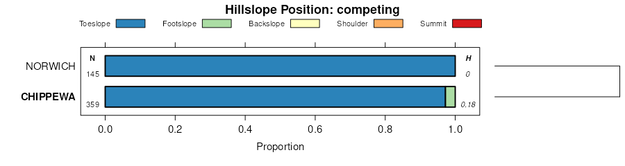
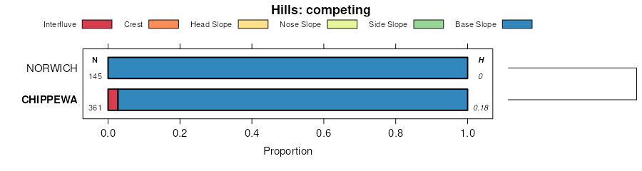
Chippewa and Norwich soils, 0 to 3 percent slopes | Cm | 12400 | 289988 | 2v32n | ny017 | 1982 | 1:15840 |
Chippewa and Norwich soils, 0 to 3 percent slopes, very stony | Cn | 5770 | 289989 | 2vcjm | ny017 | 1982 | 1:15840 |
Chippewa silt loam, 3 to 8 percent slopes | 77B | 3437 | 2723051 | 2v32s | ny023 | 2014 | 1:12000 |
Chippewa silt loam, 0 to 3 percent slopes | 77A | 1553 | 2723050 | 2v32k | ny023 | 2014 | 1:12000 |
Chippewa silt loam, 0 to 3 percent slopes | Cn | 2222 | 290777 | 2v32k | ny029 | 1979 | 1:15840 |
Chippewa silt loam, 3 to 8 percent slopes | 73B | 680 | 3100336 | 2v32s | ny051 | 2019 | 1:24000 |
Chippewa silt loam, 0 to 3 percent slopes | 73A | 465 | 3100337 | 2v32k | ny051 | 2019 | 1:24000 |
Chippewa silt loam, 0 to 3 percent slopes | Ch | 3370 | 292539 | 2v32k | ny053 | 1975 | 1:15840 |
Chippewa silt loam, stony | 804 | 6347 | 1460188 | 1l0fv | ny065 | 1993 | 1:24000 |
Chippewa silt loam, 0 to 3 percent slopes | 151 | 474 | 293343 | 2v32k | ny065 | 1993 | 1:24000 |
Chippewa silt loam, 0 to 3 percent slopes | 77A | 252 | 2482867 | 2v32k | ny069 | 2012 | 1:12000 |
Chippewa silt loam, 3 to 8 percent slopes | 77B | 248 | 2482866 | 2v32s | ny069 | 2012 | 1:12000 |
Chippewa and Norwich soils, 0 to 3 percent slopes | Cp | 9134 | 294196 | 2v32n | ny077 | 1993 | 1:24000 |
Chippewa and Norwich soils, 0 to 3 percent slopes, very stony | Cr | 255 | 294197 | 2vcjm | ny077 | 1993 | 1:24000 |
Chippewa and Norwich soils, 0 to 15 percent slopes, extremely stony | CnC | 5742 | 294461 | 2vcjp | ny095 | 1965 | 1:15840 |
Chippewa and Norwich stony silt loams, 3 to 15 percent slopes | ChC | 3056 | 294460 | 2vcjl | ny095 | 1965 | 1:15840 |
Chippewa and Norwich stony silt loams, 0 to 3 percent slopes | ChA | 2115 | 294459 | 2vcjk | ny095 | 1965 | 1:15840 |
Chippewa silt loam, 0 to 3 percent slopes | Cp | 2200 | 294597 | 2v32k | ny097 | 1976 | 1:15840 |
Chippewa channery silt loam, 0 to 3 percent slopes | Ck | 5362 | 294798 | 2vcj6 | ny101 | 1972 | 1:15840 |
Chippewa channery silt loam, 0 to 8 percent slopes | Cc | 5626 | 295803 | 2vcjc | ny107 | 1947 | 1:31680 |
Chippewa stony silt loam, 0 to 8 percent slopes, very stony | Ch | 503 | 295813 | 2vcjg | ny107 | 1947 | 1:31680 |
Erie-Chippewa channery silt loams, 0 to 3 percent slopes | ErA | 6111 | 295604 | 2vcj8 | ny109 | 1963 | 1:20000 |
Chippewa and Alden soils, 0 to 8 percent slopes | EcA | 2901 | 295602 | 2v32v | ny109 | 1963 | 1:20000 |
Volusia-Chippewa channery silt loams, 0 to 3 percent slopes | VoA | 317 | 295687 | 2v32m | ny109 | 1963 | 1:20000 |
Chippewa silt loam, 0 to 3 percent slopes | Ee | 10827 | 295347 | 2v32k | ny121 | 1969 | 1:20000 |
Chippewa silt loam, 0 to 3 percent slopes | 77A | 893 | 1407752 | 2v32k | ny123 | 1948 | 1:12000 |
Chippewa silt loam, 3 to 8 percent slopes | 77B | 612 | 1407753 | 2v32s | ny123 | 1948 | 1:12000 |
Chippewa silt loam, 0 to 3 percent slopes | Cn | 18 | 289253 | 2v32k | ny605 | 1981 | 1:24000 |
Chippewa silt loam, 0 to 8 percent slopes, extremely stony | CnB | 69 | 1383610 | 2vcjf | pa037 | 1965 | 1:20000 |
Chippewa silt loam, 0 to 3 percent slopes | ClA | 8 | 1383609 | 2v32k | pa037 | 1965 | 1:20000 |
Chippewa silt loam, 0 to 8 percent slopes | CpB | 6 | 1596613 | 1qldn | pa039 | 1973 | 1:20000 |
Norwich and Chippewa channery silt loams, 0 to 8 percent slopes, rubbly | NxB | 12754 | 299322 | 2vcjq | pa069 | 1976 | 1:20000 |
Norwich and Chippewa channery silt loams, 0 to 3 percent slopes | NcA | 2626 | 299320 | 2vcj9 | pa069 | 1976 | 1:20000 |
Norwich and Chippewa channery silt loams, 3 to 8 percent slopes | NcB | 1867 | 299321 | 2vcjd | pa069 | 1976 | 1:20000 |
Chippewa silt loam, 0 to 8 percent slopes, extremely stony | CnB | 8852 | 296428 | 2vcjf | pa079 | 1974 | 1:20000 |
Chippewa silt loam, 0 to 3 percent slopes | ClA | 6037 | 296426 | 2v32k | pa079 | 1974 | 1:20000 |
Chippewa silt loam, 3 to 8 percent slopes | ClB | 2151 | 296427 | 2v32s | pa079 | 1974 | 1:20000 |
Chippewa and Norwich soils, 0 to 8 percent slopes, extremely stony | CnB | 18326 | 296289 | 2vcjj | pa089 | 1975 | 1:20000 |
Chippewa and Norwich silt loams, 0 to 5 percent slopes | CmA | 1562 | 296288 | 2v32p | pa089 | 1975 | 1:20000 |
Chippewa silt loam, 0 to 8 percent slopes, extremely stony | CkB | 2518 | 543259 | 2vcjf | pa095 | 2007 | 1:12000 |
Chippewa silt loam, 3 to 8 percent slopes | ChB | 761 | 543258 | 2v32s | pa095 | 2007 | 1:12000 |
Chippewa silt loam, 0 to 3 percent slopes | ChA | 267 | 543257 | 2v32k | pa095 | 2007 | 1:12000 |
Chippewa channery silt loam, 0 to 8 percent slopes, extremely stony | CksB | 113 | 2432565 | 2vcjh | pa105 | 2007 | 1:24000 |
Chippewa silt loam, 0 to 8 percent slopes | CkB | 32 | 1882857 | 2v32t | pa105 | 2007 | 1:24000 |
Norwich and Chippewa soils, 0 to 3 percent slopes | NcA | 2501 | 297072 | 2v32q | pa115 | 1968 | 1:20000 |
Norwich and Chippewa soils, 3 to 8 percent slopes | NcB | 1447 | 297073 | 2v32r | pa115 | 1968 | 1:20000 |
Norwich and Chippewa soils, 0 to 8 percent slopes, extremely stony | NsB | 688 | 297074 | 2vcjn | pa115 | 1968 | 1:20000 |
Norwich and Chippewa channery silt loams, 0 to 8 percent slopes, rubbly | NxB | 3 | 319830 | 2vcjq | pa115 | 1968 | 1:20000 |
Chippewa silt loam, 3 to 8 percent slopes | CkB | 4302 | 297108 | 2v32s | pa117 | 1973 | 1:20000 |
Chippewa silt loam, 0 to 3 percent slopes | CkA | 3112 | 297107 | 2v32k | pa117 | 1973 | 1:20000 |
Chippewa silt loam, 0 to 8 percent slopes, extremely stony | ClB | 2901 | 297109 | 2vcjf | pa117 | 1973 | 1:20000 |
Norwich and Chippewa channery silt loams, 0 to 3 percent slopes, rubbly | NxA | 11444 | 296613 | 2vcjr | pa127 | 1977 | 1:20000 |
Norwich and Chippewa channery silt loams, 0 to 3 percent slopes | NcA | 1362 | 296612 | 2vcj9 | pa127 | 1977 | 1:20000 |
Norwich and Chippewa channery silt loams, 0 to 8 percent slopes, rubbly | NxB | 7700 | 301951 | 2vcjq | pa131 | 1976 | 1:20000 |
Norwich and Chippewa channery silt loams, 0 to 3 percent slopes | NcA | 2155 | 301949 | 2vcj9 | pa131 | 1976 | 1:20000 |
Norwich and Chippewa channery silt loams, 3 to 8 percent slopes | NcB | 1485 | 301950 | 2vcjd | pa131 | 1976 | 1:20000 |
Chippewa silt loam, 0 to 8 percent slopes | CpB | 3985 | 539222 | l338 | pa609 | 1979 | 1:20000 |
Chippewa silt loam, 3 to 8 percent slopes | CpB | 9942 | 296752 | 2v32s | pa610 | 1978 | 1:20000 |
Chippewa silt loam, 0 to 3 percent slopes | CpA | 8853 | 296751 | 2v32k | pa610 | 1978 | 1:20000 |