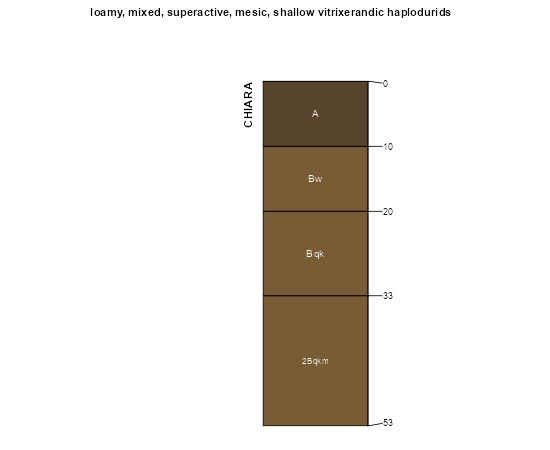
| Chiara silt loam, 1 to 8 percent slopes | 25 | 53643 | 80228 | 2ph0 | id704 | 1992 | 1:24000 |
Cherry Spring-Cortez-Chiara association | CG | 19524 | 476055 | hzcm | nv612 | 1968 | 1:24000 |
Chiara-Brock association | CL | 10293 | 476058 | hzcq | nv612 | 1968 | 1:24000 |
Chiara-Cherry Spring association | CM | 8542 | 476059 | hzcr | nv612 | 1968 | 1:24000 |
Chiara-Dewar association | 284 | 7118 | 2518919 | 2t6wm | nv612 | 1968 | 1:24000 |
Bioya-Chiara-Cortez association | 202 | 3556 | 2519387 | 2qj9m | nv612 | 1968 | 1:24000 |
Cherry Spring-Hunnton-Chiara association | 1193 | 995 | 2519392 | 2qjp2 | nv612 | 1968 | 1:24000 |
Hunnton-Chiara-Wieland association | 486 | 53 | 2518901 | 2rn4p | nv612 | 1968 | 1:24000 |
Chiara-Orovada association | 2577 | 22 | 2519391 | 2qjp1 | nv612 | 1968 | 1:24000 |
Hunnton-Chiara-Wieland association | 486 | 6436 | 2633996 | 2rhhm | nv621 | 1971 | 1:24000 |
Hunnton-Chiara association | 481 | 3563 | 2633999 | 2t6gp | nv621 | 1971 | 1:24000 |
Chiara-Chiara, cobbly-Chiara, very cobbly association | 2571 | 105072 | 477192 | j0k9 | nv763 | 1986 | 1:24000 |
Bartome-Chiara association | 2804 | 60882 | 477231 | 2t6wg | nv763 | 1986 | 1:24000 |
Chiara, very cobbly-Chiara association | 2573 | 39590 | 477194 | j0kc | nv763 | 1986 | 1:24000 |
Chiara-Chiara, moderately eroded association | 2572 | 29735 | 477193 | j0kb | nv763 | 1986 | 1:24000 |
Dacker-Chiara association | 2615 | 25615 | 477200 | j0kk | nv763 | 1986 | 1:24000 |
Chiara-Dacker-Shalake association | 2575 | 25110 | 477195 | j0kd | nv763 | 1986 | 1:24000 |
Zevadez-Chiara association | 2776 | 17895 | 477219 | j0l5 | nv763 | 1986 | 1:24000 |
Hunnton-Chiara-Wieland association | 1229 | 13045 | 477046 | 2rn4p | nv763 | 1986 | 1:24000 |
Shalake-Chiara-Shalake, gently sloping association | 2600 | 11450 | 477197 | j0kg | nv763 | 1986 | 1:24000 |
Clurde-Zevadez-Chiara association | 1157 | 8005 | 477033 | j0d5 | nv763 | 1986 | 1:24000 |
Dewar-Chiara-Chiara, very cobbly association | 2521 | 6835 | 477184 | j0k1 | nv763 | 1986 | 1:24000 |
Chiara association | 189 | 5910 | 2633943 | 2rhfz | nv763 | 1986 | 1:24000 |
Bioya-Bilbo-Chiara association | 233 | 3190 | 477176 | j0js | nv763 | 1986 | 1:24000 |
Hunnton-Chiara-Bilbo association | 1227 | 2550 | 477044 | j0dj | nv763 | 1986 | 1:24000 |
Sodhouse-Chiara association | 691 | 1318 | 2519976 | 2qjpj | nv763 | 1986 | 1:24000 |
Chiara-Orovada association | 2577 | 1128 | 477196 | j0kf | nv763 | 1986 | 1:24000 |
Cherry Spring-Hunnton-Chiara association | 1193 | 248 | 477036 | j0d8 | nv763 | 1986 | 1:24000 |
Karpp-Chiara-Wieland association | 651 | 2050 | 2511447 | 2q904 | nv764 | 2021 | 1:24000 |
Chiara ashy silt loam, 2 to 15 percent slopes | 1030 | 569 | 2517692 | 2q909 | nv764 | 2021 | 1:24000 |
Chiara-Bioya association | 371 | 127 | 2511448 | 2q905 | nv764 | 2021 | 1:24000 |
Hunnton-Chiara-Wieland association | 486 | 60 | 2511449 | 2q906 | nv764 | 2021 | 1:24000 |
Dewar-Chiara-Hunnton association | 133 | 25980 | 474899 | hy5b | nv765 | 1986 | 1:24000 |
Dacker-Chiara-Peeko association | 163 | 11623 | 474916 | hy5w | nv765 | 1986 | 1:24000 |
Peeko-Chiara association | 127 | 9830 | 474894 | hy55 | nv765 | 1986 | 1:24000 |
Chiara-Dewar-Enko association | 144 | 8785 | 474908 | 2t6wl | nv765 | 1986 | 1:24000 |
Chiara-Wieland-Enko association | 374 | 7390 | 2633853 | 2rgmv | nv765 | 1986 | 1:24000 |
Enko-Chiara-Kelk association | 171 | 5600 | 474918 | hy5y | nv765 | 1986 | 1:24000 |
Hunnton-Chiara-Wieland association | 094 | 3660 | 474861 | 2rn4p | nv765 | 1986 | 1:24000 |
Hunnton-Chiara-Bilbo association | 090 | 3150 | 474859 | hy41 | nv765 | 1986 | 1:24000 |
Peeko-Chiara-Puett association | 125 | 2420 | 474892 | hy53 | nv765 | 1986 | 1:24000 |
Chiara-Kelk-Kelk, rarely flooded association | 141 | 2190 | 474907 | hy5l | nv765 | 1986 | 1:24000 |
Wieland-Chiara-Puett association | 1276 | 1235 | 2633852 | 2rgmt | nv765 | 1986 | 1:24000 |
Chiara-Dewar-Enko association | 273 | 15723 | 478279 | 2t6wl | nv766 | 1994 | 1:24000 |
Dewar-Chiara-Hunnton association | 260 | 12640 | 478276 | 2t6wj | nv766 | 1994 | 1:24000 |
Peeko-Chiara association | 185 | 8541 | 478248 | j1nc | nv766 | 1994 | 1:24000 |
Chiara-Peeko-Urmafot association | 276 | 6975 | 478281 | j1pf | nv766 | 1994 | 1:24000 |
Cobre-Hundraw-Chiara association | 242 | 5075 | 478270 | j1p2 | nv766 | 1994 | 1:24000 |
Chiara-Parisa-Enko association | 279 | 1623 | 478284 | j1pj | nv766 | 1994 | 1:24000 |
Chiara-Kelk association | 270 | 204 | 478278 | j1pb | nv766 | 1994 | 1:24000 |
Enko-Chiara-Kelk association | 177 | 84 | 2633883 | 2rgns | nv766 | 1994 | 1:24000 |
Hunnton-Chiara-Wieland association | 486 | 24367 | 478935 | 2rn4p | nv767 | 1986 | 1:24000 |
Chiara-Wieland-Enko association | 374 | 19841 | 478893 | j2b5 | nv767 | 1986 | 1:24000 |
Hunnton-Chiara association | 481 | 14731 | 478932 | j2cf | nv767 | 1986 | 1:24000 |
Orovada-Puett-Chiara association | 494 | 13591 | 478940 | j2cp | nv767 | 1986 | 1:24000 |
Dewar-Chiara-Gance association | 154 | 10174 | 478757 | j25s | nv767 | 1986 | 1:24000 |
Norfork-Loomis-Chiara association | 521 | 9503 | 478947 | j2cx | nv767 | 1986 | 1:24000 |
Izod-Porrone-Chiara association | 972 | 8925 | 479025 | j2gf | nv767 | 1986 | 1:24000 |
Karpp-Chiara-Wieland association | 651 | 7237 | 478977 | 2wbj7 | nv767 | 1986 | 1:24000 |
Karpp-Chiara-Rad association | 650 | 6807 | 478976 | j2dv | nv767 | 1986 | 1:24000 |
Chiara-Cherry Spring-Orovada association | 370 | 6141 | 478891 | j2b3 | nv767 | 1986 | 1:24000 |
Spilock-Gochea-Chiara association | 813 | 4895 | 479006 | j2ft | nv767 | 1986 | 1:24000 |
Chiara-Kelk-Kelk, rarely flooded association | 379 | 4889 | 478895 | j2b7 | nv767 | 1986 | 1:24000 |
Chiara-Bioya association | 371 | 3884 | 478892 | j2b4 | nv767 | 1986 | 1:24000 |
Wieland-Tuffo-Chiara association | 1274 | 3695 | 478737 | j254 | nv767 | 1986 | 1:24000 |
Gance-Chiara-Hunnton association | 432 | 3503 | 478907 | j2bm | nv767 | 1986 | 1:24000 |
Chiara-Peeko-Izod association | 380 | 2437 | 478896 | j2b8 | nv767 | 1986 | 1:24000 |
Chiara-Spilock-Kelk association | 378 | 1952 | 478894 | j2b6 | nv767 | 1986 | 1:24000 |
Wieland-Chiara-Puett association | 1276 | 624 | 478738 | j255 | nv767 | 1986 | 1:24000 |
Dewar-Chiara-Hunnton association | 147 | 189 | 2633863 | 2t6wj | nv767 | 1986 | 1:24000 |
Buffaran-Chiara association | 2542 | 18851 | 479127 | j2kq | nv768 | 1985 | 1:63360 |
Chiara-Filiran association | 280 | 5813 | 479160 | j2ls | nv768 | 1985 | 1:63360 |
Beoska-Chiara association | 174 | 1452 | 479076 | 2v440 | nv768 | 1985 | 1:63360 |
Zineb-Chiara-Wieland association | 1681 | 1250 | 479069 | j2hv | nv768 | 1985 | 1:63360 |
Chiara-Dewar association | 284 | 1225 | 479161 | 2t6wm | nv768 | 1985 | 1:63360 |
Bliss-Chiara association, moderately steep | 162 | 3716 | 475233 | hyj3 | nv769 | 1986 | 1:24000 |
Bliss-Chiara association, sloping | 161 | 1575 | 475232 | hyj2 | nv769 | 1986 | 1:24000 |
Chiara stony very fine sandy loam, 2 to 4 percent slopes | 180 | 335 | 475238 | hyj8 | nv769 | 1986 | 1:24000 |
Bioya-Chiara-Cortez association | 202 | 39255 | 479513 | j2z5 | nv775 | 1985 | 1:24000 |
Orovada-Wieland-Chiara association | 706 | 7575 | 479707 | j35f | nv775 | 1985 | 1:24000 |
Chiara-Dewar association | 284 | 6245 | 479595 | 2t6wm | nv775 | 1985 | 1:24000 |
Chiara-Orovada association | 282 | 4925 | 479593 | j31r | nv775 | 1985 | 1:24000 |
Beoska-Chiara association | 174 | 4855 | 479502 | 2v440 | nv775 | 1985 | 1:24000 |
Chiara-Tenabo association | 283 | 4165 | 479594 | j31s | nv775 | 1985 | 1:24000 |
Chiara-Trunk-Midraw association | 285 | 2725 | 479596 | j31v | nv775 | 1985 | 1:24000 |
Chiara-Jenor association | 286 | 2630 | 479597 | j31w | nv775 | 1985 | 1:24000 |
Cherry Spring-Cortez-Chiara association | CG | 516 | 2634068 | 2rn38 | nv775 | 1985 | 1:24000 |
Chiara-Dacker-McConnel association | 185 | 22292 | 475615 | hyxf | nv777 | 1993 | 1:24000 |
Chiara-Hunnton association | 186 | 10064 | 475616 | hyxg | nv777 | 1993 | 1:24000 |
Chiara association | 189 | 8917 | 475618 | hyxj | nv777 | 1993 | 1:24000 |
Chiara-Boger association | 187 | 7038 | 475617 | hyxh | nv777 | 1993 | 1:24000 |
Bliss-Chiara association | 161 | 6236 | 475585 | hywg | nv777 | 1993 | 1:24000 |
Dacker-Chiara association | 780 | 3257 | 475923 | hz7c | nv777 | 1993 | 1:24000 |
Dewar-Chiara-Burrita association | 1315 | 2817 | 475481 | hys3 | nv777 | 1993 | 1:24000 |
Dugchip-Chiara association | 844 | 2662 | 475953 | hz8b | nv777 | 1993 | 1:24000 |
Chiara-McConnel association | 184 | 2349 | 475614 | hyxd | nv777 | 1993 | 1:24000 |
Bartome-Chiara association | 1010 | 989 | 475359 | 2t6wg | nv777 | 1993 | 1:24000 |
Sodhouse-Chiara association | 691 | 647 | 475884 | hz63 | nv777 | 1993 | 1:24000 |
Hunnton-Chiara association | 1010 | 17696 | 480134 | 2t6gp | nv780 | 1990 | 1:24000 |
Chiara-Kelk association | 1032 | 5313 | 480141 | j3mf | nv780 | 1990 | 1:24000 |
Chiara silt loam, 2 to 15 percent slopes | 1030 | 3383 | 480139 | j3mc | nv780 | 1990 | 1:24000 |
Chiara-Bioya association | 371 | 602 | 2633985 | 2rhh9 | nv780 | 1990 | 1:24000 |