| Chavies fine sandy loam, 0 to 2 percent slopes, rarely flooded | uChrA | 955 | 549234 | 2yj78 | ky101 | 1964 | 1:15840 |
Chavies fine sandy loam, 2 to 6 percent slopes, rarely flooded | uChrB | 917 | 549235 | 2yj79 | ky101 | 1964 | 1:15840 |
Chavies fine sandy loam, 2 to 6 percent slopes | ChB | 654 | 550286 | lgm5 | ky135 | 1998 | 1:20000 |
Chavies fine sandy loam, 6 to 12 percent slopes | ChC | 333 | 550287 | lgm6 | ky135 | 1998 | 1:20000 |
Chavies fine sandy loam, 6 to 20 percent slopes | ChD | 559 | 549310 | lflp | ky139 | 1989 | 1:20000 |
Chavies fine sandy loam, 2 to 6 percent slopes, rarely flooded | uChrB | 286 | 549309 | 2yj79 | ky139 | 1989 | 1:20000 |
Chavies fine sandy loam, 2 to 6 percent slopes | ChB | 200 | 548920 | lf63 | ky161 | 1983 | 1:20000 |
Chavies fine sandy loam, 6 to 12 percent slopes | ChC | 180 | 548921 | lf64 | ky161 | 1983 | 1:20000 |
Chavies fine sandy loam, 0 to 3 percent slopes, frequently flooded | CnA | 402 | 1597398 | 1qm6z | ky602 | 1972 | 1:12000 |
Chavies fine sandy loam, 0 to 3 percent slopes, rarely flooded | CkA | 279 | 1597396 | 1qm6x | ky602 | 1972 | 1:12000 |
Chavies fine sandy loam, 0 to 3 percent slopes, occasionally flooded | CmA | 210 | 1596158 | 1qkxz | ky602 | 1972 | 1:12000 |
Chavies fine sandy loam, 0 to 6 percent slopes | ChB | 958 | 552026 | ljf9 | ky603 | 1968 | 1:15840 |
Chavies fine sandy loam, 6 to 12 percent slopes | ChC | 290 | 552027 | ljfb | ky603 | 1968 | 1:15840 |
Chavies fine sandy loam, 0 to 6 percent slopes | ChA | 1343 | 550388 | lgqg | ky605 | 1975 | 1:20000 |
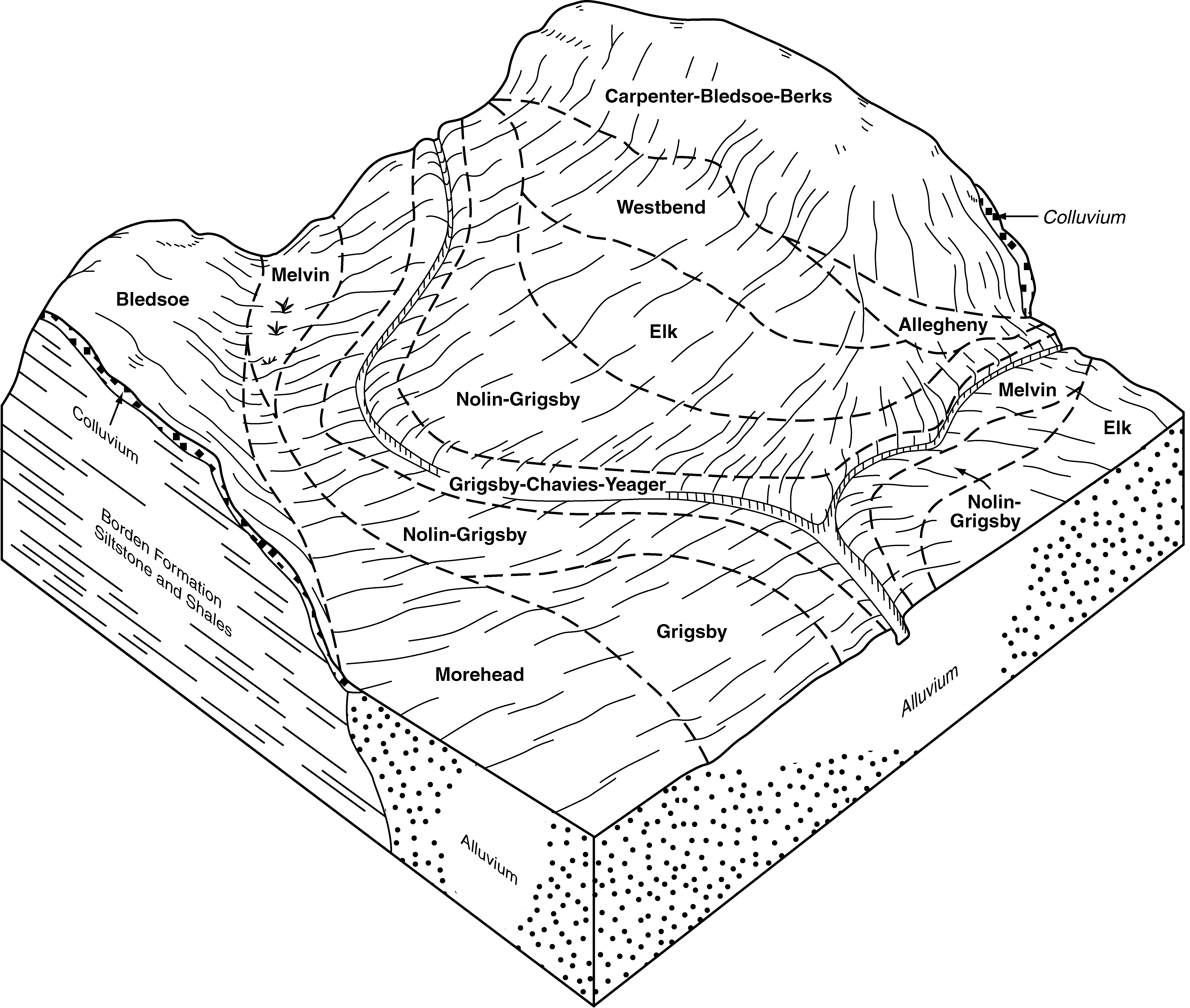
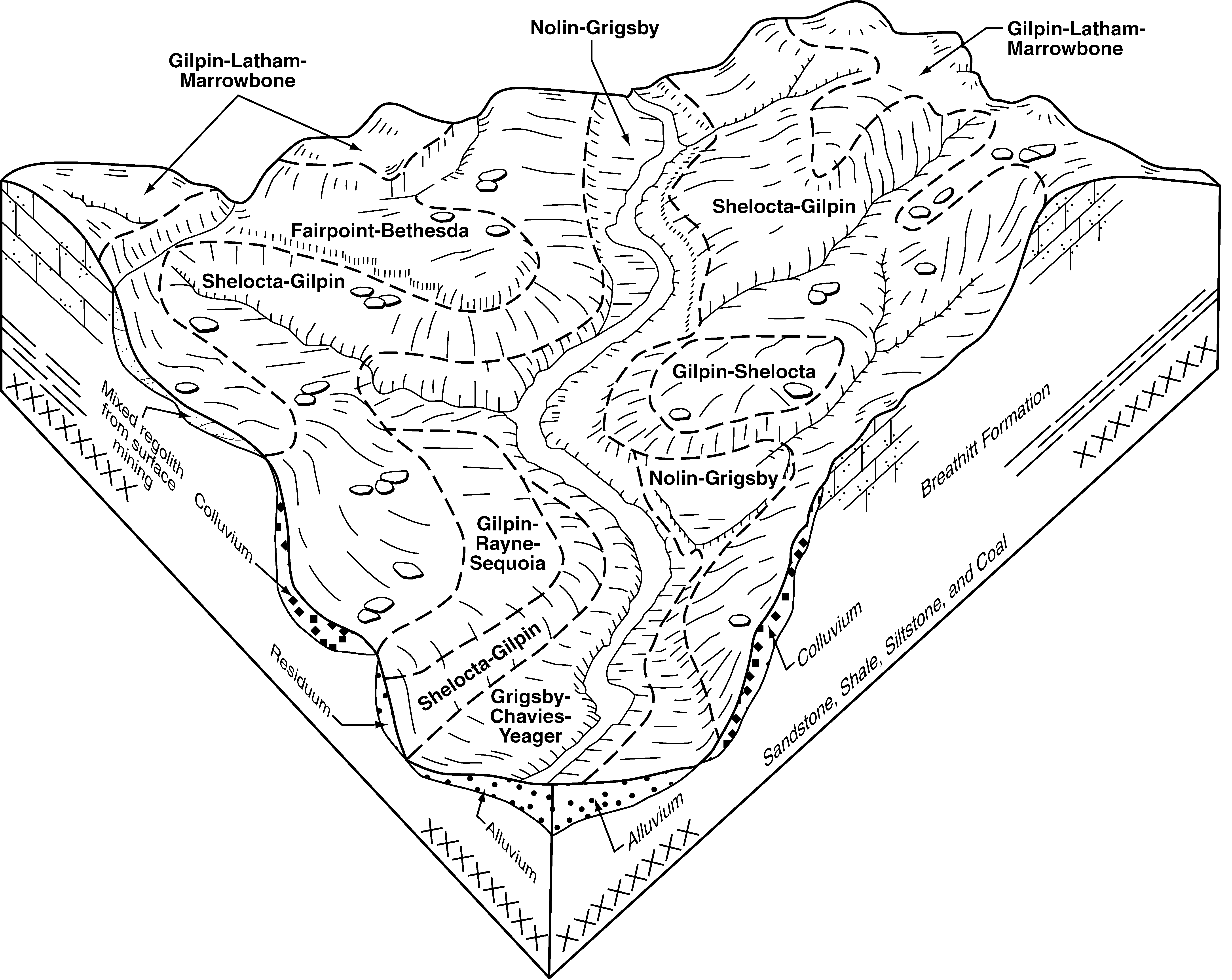
Grigsby-Chavies-Yeager complex, 2 to 55 percent slopes, frequently flooded | GyF | 3207 | 557770 | lqdl | ky616 | 2004 | 1:24000 |
Chavies fine sandy loam, 2 to 6 percent slopes, rarely flooded | ChB | 220 | 550858 | lh6m | ky639 | 1991 | 1:24000 |
Chavies fine sandy loam, acid variant, 0 to 6 percent slopes | ChB | 260 | 1478755 | 1lmrs | ky645 | 1971 | 1:20000 |
Chavies loam, 0 to 2 percent slopes | CcA | 8 | 2109000 | 28sl8 | oh031 | 1996 | 1:15840 |
Urban land-Chavies complex, 0 to 3 percent slopes | UsA | 938 | 536122 | kzw8 | oh081 | 1987 | 1:15840 |
Chavies loam, 0 to 6 percent slopes | CeB | 2209 | 537427 | l17c | oh115 | 1992 | 1:15840 |
Chavies loam, 2 to 6 percent slopes | CcB | 8 | 1541132 | 1nqny | oh115 | 1992 | 1:15840 |
Chavies loam, 2 to 6 percent slopes | CcB | 990 | 537866 | l1pj | oh119 | 1989 | 1:15840 |
Chavies loam, 0 to 2 percent slopes | CcA | 827 | 537865 | l1ph | oh119 | 1989 | 1:15840 |
Chavies silt loam, rarely flooded | ChA | 72 | 170851 | 5qsb | oh141 | 1997 | 1:15840 |
Chavies silt loam, 2 to 6 percent slopes, rarely flooded | ChB | 486 | 536367 | l045 | oh163 | 1998 | 1:15840 |
Chavies silt loam, 0 to 2 percent slopes, rarely flooded | ChA | 193 | 536366 | l044 | oh163 | 1998 | 1:15840 |
Chavies silt loam, 6 to 15 percent slopes | CmC | 112 | 536368 | l046 | oh163 | 1998 | 1:15840 |
Chavies fine sandy loam, 0 to 2 percent slopes | CeA | 200 | 2421644 | 2m8xk | pa005 | 2012 | 1:24000 |
Chavies fine sandy loam | Ch | 307 | 693704 | r8vk | pa041 | 1980 | 1:15840 |
Chavies fine sandy loam, 3 to 8 percent slopes, moderately eroded | CnB2 | 1111 | 540721 | l4nm | pa043 | 1967 | 1:15840 |
Chavies fine sandy loam, 0 to 3 percent slopes | CnA | 624 | 540720 | l4nl | pa043 | 1967 | 1:15840 |
Chavies fine sandy loam, 8 to 15 percent slopes, moderately eroded | CnC2 | 344 | 540722 | l4nn | pa043 | 1967 | 1:15840 |
Chavies fine sandy loam, 0 to 2 percent slopes | ChA | 960 | 1591037 | 1qdls | pa051 | 2005 | 1:24000 |
Chavies fine sandy loam, 3 to 8 percent slopes, rarely flooded | ChB | 361 | 1591038 | 2sft3 | pa051 | 2005 | 1:24000 |
Chavies fine sandy loam, 0 to 2 percent slopes | ChA | 483 | 2420173 | 2m7d3 | pa063 | 2012 | 1:24000 |
Chavies fine sandy loam, 0 to 3 percent slopes, rarely flooded | ChA | 1510 | 2399188 | 2sft0 | pa065 | 2012 | 1:12000 |
Chavies fine sandy loam | Ch | 575 | 693929 | r92t | pa099 | 1980 | 1:15840 |
Chavies silt loam, 0 to 3 percent slopes | ChA | 2029 | 542074 | l628 | pa111 | 1977 | 1:20000 |
Chavies silt loam, 3 to 8 percent slopes | ChB | 734 | 542075 | l629 | pa111 | 1977 | 1:20000 |
Chavies fine sandy loam, 0 to 2 percent slopes | ChA | 1098 | 544612 | l8q4 | pa129 | 2003 | 1:24000 |
Chavies loam, 2 to 8 percent slopes | CaB | 1592 | 545467 | l9lq | pa605 | 1975 | 1:20000 |
Chavies fine sandy loam | 19 | 3728 | 517549 | kck4 | va015 | 1978 | 1:15840 |
Chavies variant, sandy loam | 9 | 2494 | 516713 | kbp5 | va071 | 1981 | 1:15840 |
Chavies fine sandy loam, 0 to 4 percent slopes, rarely flooded | 13A | 4847 | 518354 | kdd3 | va165 | 1980 | 1:20000 |
Chavies fine sandy loam | 19 | 34 | 3025800 | 2xd5g | va820 | | 1:12000 |
Chavies fine sandy loam, rarely flooded | Ch | 1075 | 513049 | k6vz | wv007 | 1990 | 1:24000 |
Chavies fine sandy loam, protected | Cp | 775 | 513050 | k6w0 | wv007 | 1990 | 1:24000 |
Chavies fine sandy loam | Ch | 1529 | 516091 | kb13 | wv015 | 1998 | 1:24000 |
Chavies fine sandy loam, warm, 0 to 3 percent slopes, rarely flooded | Ch | 2642 | 553044 | 2sft1 | wv025 | 2002 | 1:24000 |
Urban land-Chavies complex | Ur | 5360 | 532239 | kvv0 | wv047 | 1993 | 1:24000 |
Chavies loam | Cv | 385 | 532206 | kvsy | wv047 | 1993 | 1:24000 |
Chavies fine sandy loam, 3 to 8 percent slopes | CgB | 116 | 1608732 | 1r00l | wv051 | 2007 | 1:12000 |
Chavies fine sandy loam | Ch | 2736 | 515392 | k99k | wv075 | 1992 | 1:24000 |
Chavies fine sandy loam, 0 to 3 percent slopes, rarely flooded | Ch | 427 | 1868177 | 2sft0 | wv077 | 1955 | 1:20000 |
Chavies fine sandy loam, moist, 0 to 3 percent slopes, rarely flooded | Ch | 804 | 515456 | 2sft2 | wv097 | 1981 | 1:20000 |
Chavies fine sandy loam, moist, 0 to 3 percent slopes, rarely flooded | Ch | 3144 | 515111 | 2sft2 | wv101 | 1992 | 1:24000 |
Chavies fine sandy loam, 0 to 3 percent slopes | ChA | 1116 | 1384171 | 1hgbp | wv600 | 2005 | 1:24000 |
Chavies-Urban land complex, 0 to 8 percent slopes | CkB | 894 | 1384236 | 1hgds | wv600 | 2005 | 1:24000 |
Chavies fine sandy loam, 3 to 8 percent slopes | ChB | 642 | 1384172 | 1hgbq | wv600 | 2005 | 1:24000 |
Chavies fine sandy loam, 8 to 15 percent slopes | ChC | 341 | 1384173 | 1hgbr | wv600 | 2005 | 1:24000 |
Chavies fine sandy loam, moist, 0 to 3 percent slopes, rarely flooded | Cv | 765 | 514039 | 2sft2 | wv602 | 1965 | 1:20000 |
Chavies fine sandy loam, moist, 0 to 3 percent slopes, rarely flooded | Ch | 596 | 515548 | 2sft2 | wv603 | 1978 | 1:20000 |
Chavies fine sandy loam | Ch | 382 | 1602547 | 1qsl2 | wv604 | 1970 | 1:20000 |
Chavies fine sandy loam | Ch | 604 | 515774 | k9pw | wv610 | 1973 | 1:20000 |
Urban land-Chavies complex | Ud | 595 | 1155565 | 17sg9 | wv620 | 2005 | 1:24000 |
Urban land-Chavies complex, protected | Uf | 380 | 1155564 | 17sg8 | wv620 | 2005 | 1:24000 |
Chavies fine sandy loam | Ch | 355 | 1155536 | 17sfc | wv620 | 2005 | 1:24000 |
Chavies fine sandy loam, protected | Ck | 160 | 1155537 | 17sfd | wv620 | 2005 | 1:24000 |
Chavies fine sandy loam, 0 to 3 percent slopes, rarely flooded | ChA | 329 | 2427099 | 2mglj | wv622 | 2010 | 1:12000 |
Chavies fine sandy loam, 0 to 3 percent slopes, rarely flooded | ChA | 18 | 2497756 | 2mglj | wv623 | 2010 | 1:12000 |
Chavies fine sandy loam, warm, 0 to 3 percent slopes, rarely flooded | ChA | 1051 | 2453203 | 2sft1 | wv705 | 2009 | 1:24000 |
Chavies fine sandy loam, moist, 3 to 8 percent slopes, rarely flooded | ChB | 1284 | 2512841 | 2sft4 | wv767 | 2011 | 1:20000 |