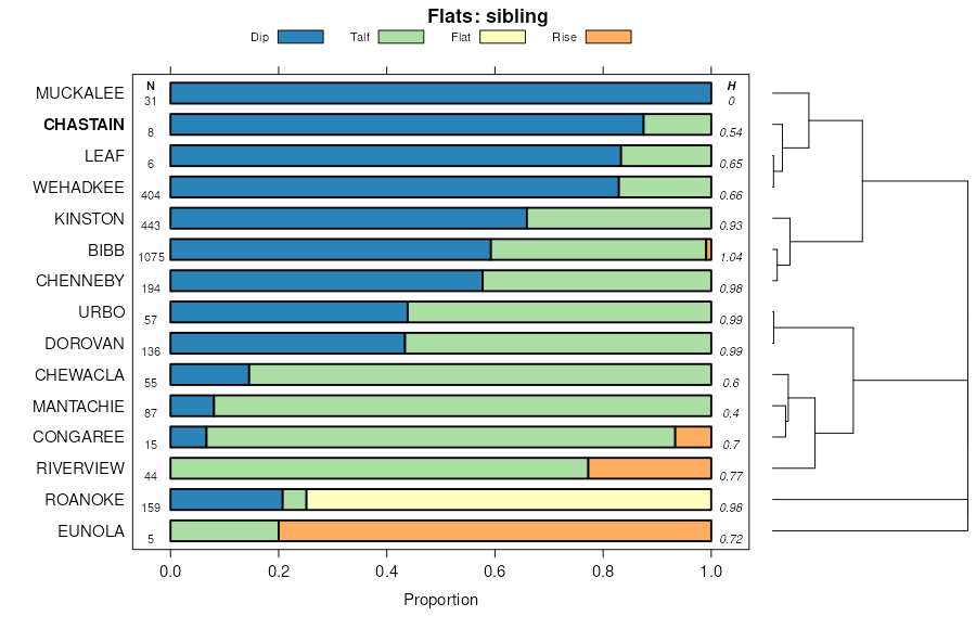
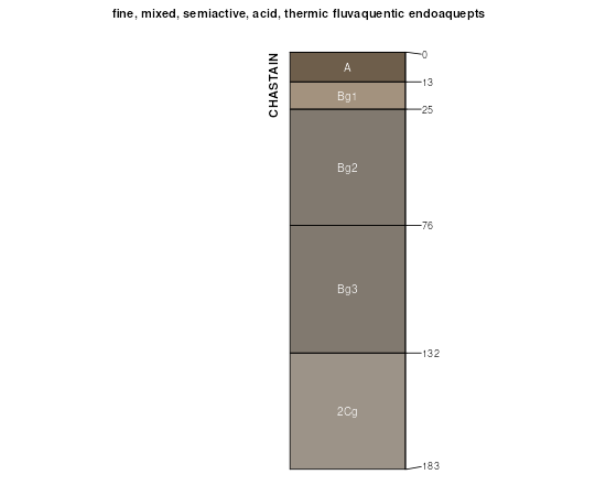
Official Series Description


Lab Data Summary

Aggregate lab data for the CHASTAIN soil series. This aggregation is based on all pedons with a current taxon name of CHASTAIN, and applied along 1-cm thick depth slices. Solid lines are the slice-wise median, bounded on either side by the interval defined by the slice-wise 5th and 95th percentiles. The median is the value that splits the data in half. Five percent of the data are less than the 5th percentile, and five percent of the data are greater than the 95th percentile. Values along the right hand side y-axis describe the proportion of pedon data that contribute to aggregate values at this depth. For example, a value of "90%" at 25cm means that 90% of the pedons correlated to CHASTAIN were used in the calculation. Source: KSSL snapshot . Methods used to assemble the KSSL snapshot used by SoilWeb / SDE

Click the image to view it full size.

Pedons used in the lab summary:

MLRALab IDPedon IDTaxonnameCINSSL / NASIS ReportsLink To SoilWeb GMap
133A81P019881GA175002Chastain5Primary | Supplementary | Taxonomy | Pedon | Water Retention | Correlation | Andic Soil Properties32.4321175,-82.819313
133A81P020181GA175005Chastain7Primary | Supplementary | Taxonomy | Pedon | Water Retention | Correlation | Andic Soil Properties32.4915619,-82.889595
133AS88SC005-8S1988SC005003Chastain3Primary | Supplementary | Taxonomy | Pedon | Water Retention | Correlation | Andic Soil Properties32.8929372,-81.4495525
133AS90SC069-30S1995SC069013Chastain3Primary | Supplementary | Taxonomy | Pedon | Water Retention | Correlation | Andic Soil Properties34.5543286,-79.7970081
133A08N0438S2008SC085017-ChastainChastain6Primary | Supplementary | Taxonomy | Pedon | Water Retention | Correlation | Andic Soil Properties33.8472214,-80.5727768
133A08N0431S2008SC085022-ChastainChastain6Primary | Supplementary | Taxonomy | Pedon | Water Retention | Correlation | Andic Soil Properties33.8827782,-80.5736084
133A08N0429S2008SC085024-ChastainChastain6Primary | Supplementary | Taxonomy | Pedon | Water Retention | Correlation | Andic Soil Properties33.6969452,-80.5455551
133A08N0428S2008SC085025-ChastainChastain6Primary | Supplementary | Taxonomy | Pedon | Water Retention | Correlation | Andic Soil Properties33.6980553,-80.5400009
135A40A3964S1965MS115001CHASTAIN7Primary | Supplementary | Taxonomy | Pedon | Water Retention | Correlation | Andic Soil Properties34.2751312,-89.1022797
135A40A3959S1965MS115002CHASTAIN6Primary | Supplementary | Taxonomy | Pedon | Water Retention | Correlation | Andic Soil Properties34.3087387,-89.1220016
13781P019581GA033003Chastain6Primary | Supplementary | Taxonomy | Pedon | Water Retention | Correlation | Andic Soil Properties33.1876526,-81.7870636
153A08N0425S2008SC085028-ChastainChastain6Primary | Supplementary | Taxonomy | Pedon | Water Retention | Correlation | Andic Soil Properties34.0158348,-79.9369431
153A08N0422S2008SC085031-ChastainChastain6Primary | Supplementary | Taxonomy | Pedon | Water Retention | Correlation | Andic Soil Properties34.0377769,-79.9905548

Water Balance

Monthly water balance estimated using a leaky-bucket style model for the CHASTAIN soil series. Monthly precipitation (PPT) and potential evapotranspiration (PET) have been estimated from the 50th percentile of gridded values (PRISM 1981-2010) overlapping with the extent of SSURGO map units containing each series as a major component. Monthly PET values were estimated using the method of Thornthwaite (1948). These (and other) climatic parameters are calculated with each SSURGO refresh and provided by the fetchOSD function of the soilDB package. Representative water storage values (“AWC” in the figures) were derived from SSURGO by taking the 50th percentile of profile-total water storage (sum[awc_r * horizon thickness]) for each soil series. Note that this representation of “water storage” is based on the average ability of most plants to extract soil water between 15 bar (“permanent wilting point”) and 1/3 bar (“field capacity”) matric potential. Soil moisture state can be roughly interpreted as “dry” when storage is depleted, “moist” when storage is between 0mm and AWC, and “wet” when there is a surplus. Clearly there are a lot of assumptions baked into this kind of monthly water balance. This is still a work in progress.

Click the image to view it full size.


Click the image to view it full size.

Sibling Summary

Siblings are those soil series that occur together in map units, in this case with the CHASTAIN series. Sketches are arranged according to their subgroup-level taxonomic structure. Source: SSURGO snapshot , parsed OSD records and snapshot of SC database .

Click the image to view it full size.

Select annual climate data summaries for the CHASTAIN series and siblings. Series are sorted according to hierarchical clustering of median values. Source: SSURGO map unit geometry and 1981-2010, 800m PRISM data .

Click the image to view it full size.

Geomorphic description summaries for the CHASTAIN series and siblings. Series are sorted according to hierarchical clustering of proportions and relative hydrologic position within an idealized landform (e.g. top to bottom). Most soil series (SSURGO components) are associated with a hillslope position and one or more landform-specific positions: hills, mountain slopes, terraces, and/or flats. Proportions can be interpreted as an aggregate representation of geomorphic membership. The values printed to the left (number of component records) and right (Shannon entropy) of stacked bars can be used to judge the reliability of trends. Small Shannon entropy values suggest relatively consistent geomorphic association, while larger values suggest lack thereof. Source: SSURGO component records .

Click the image to view it full size.

Click the image to view it full size.

There are insufficient data to create the 3D mountains figure.

Click the image to view it full size.

Click the image to view it full size.

Competing Series

Soil series competing with CHASTAIN share the same family level classification in Soil Taxonomy. Source: parsed OSD records and snapshot of the SC database .

Click the image to view it full size.

Select annual climate data summaries for the CHASTAIN series and competing. Series are sorted according to hierarchical clustering of median values. Source: SSURGO map unit geometry and 1981-2010, 800m PRISM data .

There are insufficient data to create the annual climate figure.

Geomorphic description summaries for the CHASTAIN series and competing. Series are sorted according to hierarchical clustering of proportions and relative hydrologic position within an idealized landform (e.g. top to bottom). Proportions can be interpreted as an aggregate representation of geomorphic membership. Most soil series (SSURGO components) are associated with a hillslope position and one or more landform-specific positions: hills, mountain slopes, terraces, and/or flats. The values printed to the left (number of component records) and right (Shannon entropy) of stacked bars can be used to judge the reliability of trends. Shannon entropy values close to 0 represent soil series with relatively consistent geomorphic association, while values close to 1 suggest lack thereof. Source: SSURGO component records .

There are insufficient data to create the 2D hillslope position figure.

There are insufficient data to create the 3D hills figure.

There are insufficient data to create the 3D mountains figure.

There are insufficient data to create the 3D terrace figure.

There are insufficient data to create the 3D flats position figure.

Soil series sharing subgroup-level classification with CHASTAIN, arranged according to family differentiae. Hovering over a series name will print full classification and a small sketch from the OSD. Source: snapshot of SC database .

Block Diagrams

Click a link below to display the diagram. Note that these diagrams may be from multiple survey areas.

  1. AR-2012-05-08-03 | Bradley County - April 1961

    General soil areas (Soil Survey of Bradley County, Arkansas; April 1961).

  2. MS-2012-04-27-04 | Tippah County - February 1966

    Distribution and pattern of major soils in Wilcox-Dulac-Falkner association (Soil Survey of Tippah County, Mississippi; February 1966).

  3. OK-2012-02-17-34 | Pittsburg County - May 1971

    Major soils and underlying material in soil associations 5 and 6 (Soil Survey of Pittsburg County, Oklahoma; May 1971).

Map Units

Map units containing CHASTAIN as a major component. Limited to 250 records.

Map Unit Name Symbol Map Unit Area (ac) Map Unit Key National Map Unit Symbol Soil Survey Area Publication Date Map Scale
Eunola-Chastain association134400328651c0znal03119761:20000
Chastain and Bibb soilsCb4317329621c1zyal06119731:20000
Chastain clayCh904329657c213al06320131:
Chastain soilsCc4551330892c39yal10119581:20000
Chastain silty clayCh22306565151lz2par01119591:20000
Chastain-Tawcaw associationCC2650324567bwqxga03319821:20000
Chastain and Tawcaw soils, 0 to 2 percent slopes, frequently floodedCAA1971517010921v33yga10320071:24000
Chastain loamCh2512481845wdga21519801:15840
Chewacla-Chastain associationCC4280324865bx1jga24519791:15840
Chastain loamCa2250324867bx1lga24519791:15840
Chastain and Tawcaw soils, 0 to 2 percent slopes, frequently floodedCAA2733525803622qbf4ga25120111:24000
Chastain loam, 0 to 2 percent slopes, occasionally floodedChA82524253392mdrrga25920091:12000
Chastain-Tawcaw complex, frequently floodedCh4730125163467jga60219831:20000
Leaf and Chastain soilsLid2435325208bxdlga60819651:20000
Tawcaw-Chastain association, frequently floodedTC28928325404bxlxga61019921:20000
Chastain loam, frequently floodedCh14861261724792ga62019921:20000
Chewacla-Chastain-Riverview associationCC19895325759bxzcga63419801:20000
Chastain silty clay loam, frequently floodedCh3740325825by1hga63819871:20000
Chastain and Leaf soilsCls8110325884by3dga64019651:15840
Tawcaw-Chastain-Congaree association, frequently floodedTC22595325978by6fga64119861:20000
Tawcaw-Chastain associationTC2324712582746xyga64419801:20000
Chewacla-Chastain associationCc14630326339byl2ga65419791:20000
Chastain silt loam (una)Ca11440331825c491ms01319631:15840
Chastain silty clay loam (una)Ch11430331826c492ms01319631:15840
Chastain soils, (una)Ch2393334177c6qxms13919631:15840
Chewacla and Chastain soils, 0 to 2 percent slopes, frequently floodedCmA58661145073v4snc00719991:24000
Chewacla and Chastain soils, frequently floodedCh63511154743w4znc01719831:24000
Chastain and Chenneby soils, frequently floodedCh12211156363wb6nc04719861:24000
Chastain and Bibb soils, 0 to 1 percent slopes, frequently floodedCbA366401130263sm0nc08319951:24000
Wehadkee-Chastain association, 0 to 2 percent slopes, frequently floodedWw122461135723t5mnc10119861:24000
Chastain silt loam, frequently floodedCh270781111223qmlnc11719851:24000
Chastain silt loam, 0 to 2 percent slopes, frequently floodedCkA27722335642dz6gnc12320071:24000
Chastain silt loam, 0 to 2 percent slopes, frequently floodedCh77741140313tnfnc13119881:24000
Chewacla and Chastain soils, frequently floodedCh104231161613ww4nc14119861:24000
Tawcaw-Chastain complex, frequently floodedTc163321323984frxsc00519891:20000
Chastain association, frequently floodedCS55001319464f9bsc01519741:20000
Chewacla-Chastain complex, frequently floodedCm224241320024fc4sc02519891:20000
Chastain-Chewacla complex, 0 to 2 percent slopes,frequently floodedCeA14277618792nrx1sc03119981:24000
Wehadkee-Chastain complex, 0 to 2 percent slopes,frequently floodedWcA2273620385ntkfsc03119981:24000
Chewacla-Chastain complex, 0 to 2 percent slopes, frequently floodedCmA207618798nrx7sc03119981:24000
Chastain loam, frequently floodedCh40001297394c04sc03319761:20000
Chastain-Chewacla-Congaree association, frequently floodedCh184851299464c6tsc04119691:20000
Wehadkee-Chastain association, frequently floodedWk110191299924c89sc04119691:20000
Chastain silty clay loam5629240639594pgk2sc04319801:20000
Tawcaw-Chastain complex, frequently floodedTc115211301304cdrsc04919901:20000
Tawcaw-Chastain associationTC122951325824fyvsc05319751:20000
Chewacla-Chastain complex, 0 to 2 percent slopes, frequently floodedChA509516065241qxqcsc06120051:24000
Chastain-Chewacla complex, 0 to 2 percent slopes, frequently floodedCcA216016065221qxq9sc06120051:24000
Tawcaw-Chastain association, frequently floodedTC386451305904cwlsc06719751:20000
Chastain-Chenneby complex, frequently floodedCe229921306144cxcsc06919951:24000
Chastain silty clay loamCd90781310844ddjsc07919761:20000
Chastain and Tawcaw soils, frequently floodedCH291041315054dv3sc08919851:20000
Chastain soilsCk17161382704mwbsc69019671:24000
Chastain clay, frequently floodedCh79351313374dnpsc69619881:15840
Chastain silty clay loam, 0 to 1 percent slopes, frequently flooded4A53881181523yycva00719941:24000
Bibb-Chastain complex, 0 to 2 percent slopes, frequently flooded4A1246612102241xyva03319961:24000
Chastain silt loam, 0 to 2 percent slopes, ponded7A483012102841y4va03319961:24000
Chastain loam318441188913zq6va04119741:15840
Chastain silt loamCg1277119217401qva08719731:15840
Mantachie-Chastain complexMc888119254402xva08719731:15840
Chastain loam, 0 to 2 percent slopes, ponded8A9138705264rnwgva17519961:24000
Chastain loam, 0 to 2 percent slopes, frequently flooded7A8162705263rnwfva17519961:24000
Chastain loam, 0 to 2 percent slopes, frequently flooded7A2528517230341vtyrva18320061:24000
Bibb and Chastain soils, 0 to 2 percent slopes, frequently flooded4A741517230251vtygva18320061:24000
Chastain loam, 0 to 3 percent slopes, frequently flooded9A521400794prpva76020041:24000

Map of Series Extent

Approximate geographic distribution of the CHASTAIN soil series. To learn more about how this distribution was mapped, or to compare this soil series extent to others, use the Series Extent Explorer (SEE) application. Source: generalization of SSURGO geometry .