| Cedarcreek-Sewell-Rock outcrop complex, 0 to 30 percent slopes, very stony | uCsrE | 110 | 3158450 | 2ykst | ky195 | 1986 | 1:24000 |
Cedarcreek channery loam, 15 to 25 percent slopes | CgD | 640 | 2401094 | 2lljn | md001 | 2009 | 1:12000 |
Cedarcreek channery loam, 8 to 15 percent slopes | CgC | 562 | 2401093 | 2lljm | md001 | 2009 | 1:12000 |
Cedarcreek channery loam, 25 to 45 percent slopes | CgE | 460 | 2401095 | 2lljp | md001 | 2009 | 1:12000 |
Cedarcreek channery loam, 0 to 8 percent slopes | CgB | 379 | 2401092 | 2lljl | md001 | 2009 | 1:12000 |
Cedarcreek channery loam, 45 to 65 percent slopes | CgF | 121 | 2401096 | 2lljq | md001 | 2009 | 1:12000 |
Cedarcreek extremely channery loam, 25 to 80 percent slopes, very stony | CeF | 2478 | 541785 | l5ry | pa009 | 1989 | 1:24000 |
Cedarcreek extremely channery loam, 3 to 25 percent slopes, very stony | CeC | 572 | 541784 | l5rx | pa009 | 1989 | 1:24000 |
Cedarcreek extremely channery loam, 25 to 80 percent slopes | CrF | 3 | 541871 | l5vq | pa009 | 1989 | 1:24000 |
Strip mine spoil | St | 313 | 540765 | l4q1 | pa043 | 1967 | 1:15840 |
Cedarcreek extremely channery loam, 25 to 80 percent slopes | CrF | 325 | 544847 | l8yq | pa057 | 1999 | 1:24000 |
Cedarcreek very channery loam, 3 to 25 percent slopes | CrC | 325 | 544846 | l8yp | pa057 | 1999 | 1:24000 |
Strip mines | SM | 2437 | 542040 | l615 | pa061 | 1974 | 1:20000 |
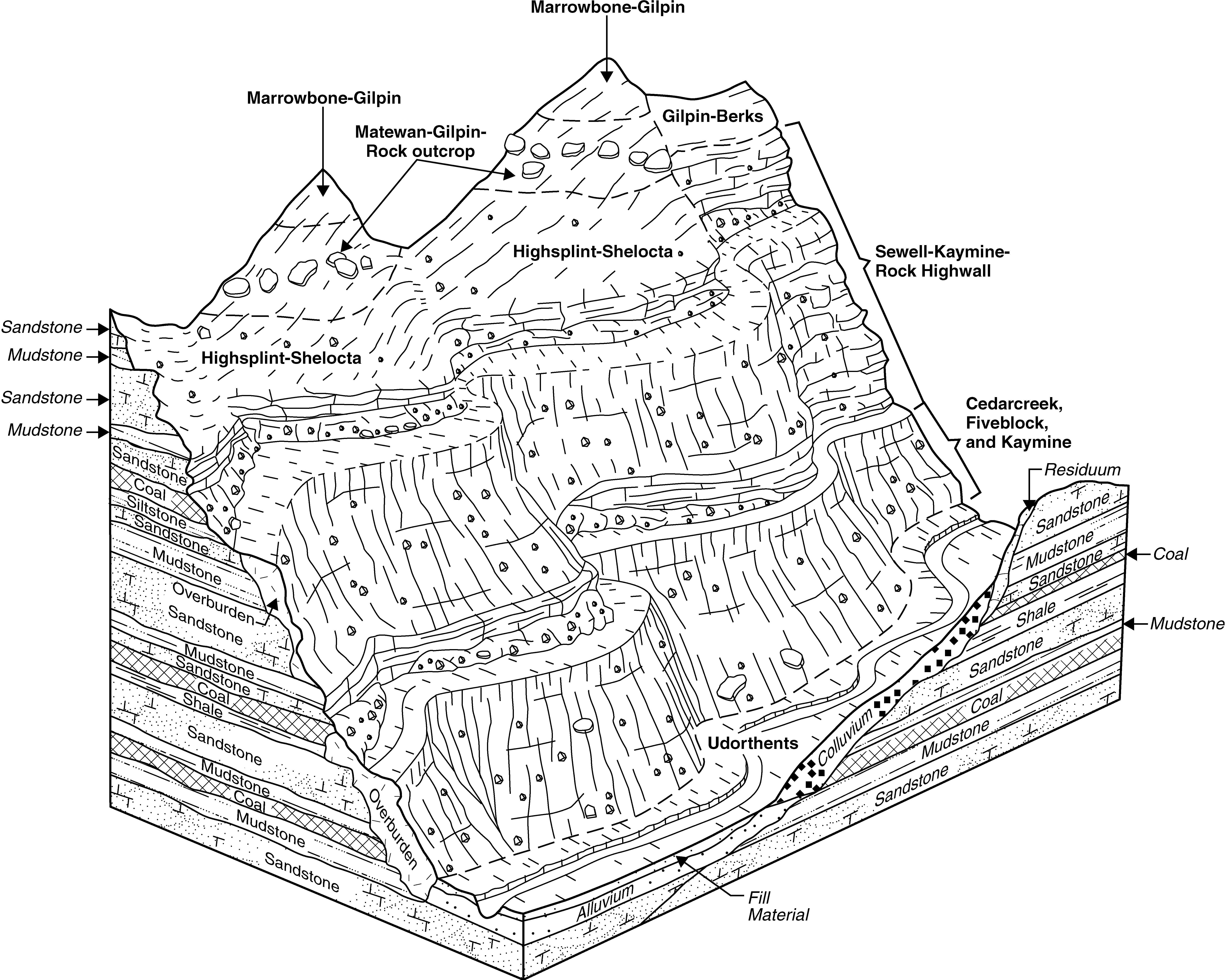
Cedarcreek, Fiveblock, and Kaymine soils, 55 to 80 percent slopes, extremely stony | 3F | 12732 | 1670882 | 1t2pf | va027 | 2006 | 1:24000 |
Shelocta-Cedarcreek complex, 35 to 55 percent slopes, very bouldery | 22E | 9435 | 1670952 | 1t2rp | va027 | 2006 | 1:24000 |
Cedarcreek-Sewell-Rock outcrop complex, 0 to 15 percent slopes, very stony | 4C | 9231 | 1670908 | 1t2q8 | va027 | 2006 | 1:24000 |
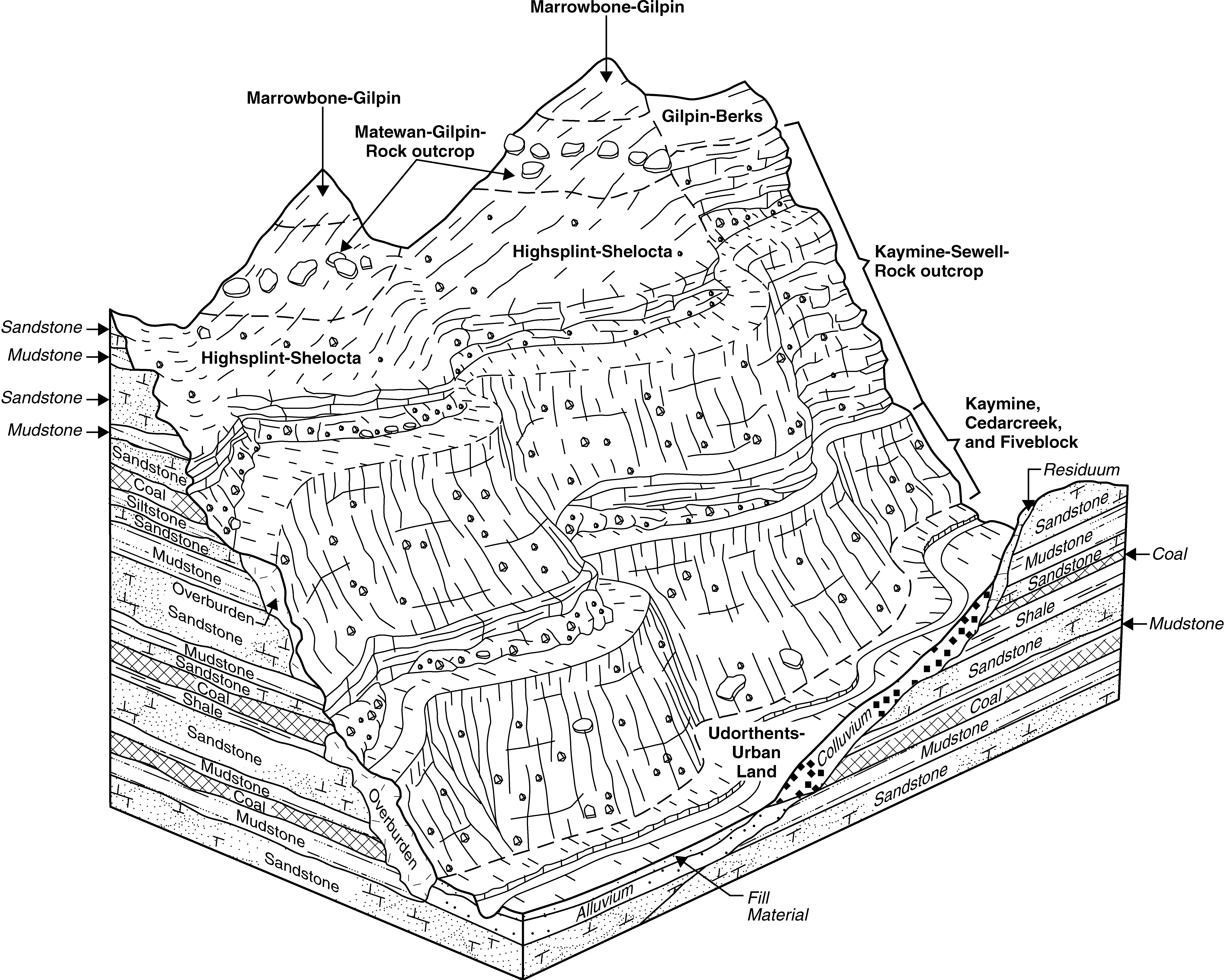
Kaymine-Cedarcreek complex, 35 to 55 percent slopes, extremely stony | 14E | 8589 | 1670881 | 1t2pd | va027 | 2006 | 1:24000 |
Kaymine-Fiveblock-Cedarcreek complex, 0 to 15 percent slopes, extremely stony | 15C | 1681 | 1670954 | 1t2rr | va027 | 2006 | 1:24000 |
Kaymine-Cedarcreek complex, 35 to 55 percent slopes, extremely stony | 14E | 5871 | 2399871 | 2lk86 | va051 | 2008 | 1:24000 |
Cedarcreek-Sewell-Rock outcrop complex, 0 to 15 percent slopes, very stony | 2C | 3425 | 2399853 | 2lk7m | va051 | 2008 | 1:24000 |
Kaymine-Fiveblock-Cedarcreek complex, 0 to 15 percent slopes, extremely stony | 16C | 3415 | 2399873 | 2lk88 | va051 | 2008 | 1:24000 |
Kaymine, Cedarcreek, and Fiveblock soils, 55 to 80 percent slopes, extremely stony | 15F | 3242 | 2399872 | 2lk87 | va051 | 2008 | 1:24000 |
Shelocta-Cedarcreek complex, 55 to 80 percent slopes, very bouldery | 23F | 2224 | 2399884 | 2lk8m | va051 | 2008 | 1:24000 |
Cedarcreek-Sewell-Rock outcrop complex, 0 to 15 percent slopes, very stony | 16C | 2269 | 1671905 | 1t3rf | va167 | 2006 | 1:24000 |
Kaymine-Cedarcreek complex, 35 to 55 percent slopes, extremely stony | 32E | 2197 | 1671899 | 1t3r7 | va167 | 2006 | 1:24000 |
Kaymine-Fiveblock-Cedarcreek complex, 0 to 15 percent slopes, extremely stony | 34C | 2029 | 1671897 | 1t3r5 | va167 | 2006 | 1:24000 |
Shelocta-Cedarcreek complex, 35 to 55 percent slopes, very bouldery | 48E | 1561 | 1671895 | 1t3r3 | va167 | 2006 | 1:24000 |
Grimsley-Cedarcreek-Berks complex, 35 to 70 percent slopes, rocky | 25E | 3870 | 522178 | kjcg | va185 | 1996 | 1:24000 |
Cedarcreek-Alticrest-Rock outcrop complex, 15 to 40 percent slopes, very stony | 14E | 1508 | 522174 | kjcb | va185 | 1996 | 1:24000 |
Cedarcreek-Rock outcrop complex, 35 to 80 percent slopes, very stony | 15E | 885 | 522185 | kjcp | va185 | 1996 | 1:24000 |
Cedarcreek-Rock outcrop complex, 0 to 15 percent slopes, very stony | 15C | 715 | 522183 | kjcm | va185 | 1996 | 1:24000 |
Cedarcreek-Rock outcrop complex, 15 to 35 percent slopes, very stony | 15D | 124 | 522184 | kjcn | va185 | 1996 | 1:24000 |
Grimsley-Cedarcreek-Berks complex, 8 to 35 percent slopes, very rocky | 25D | 120 | 522177 | kjcf | va185 | 1996 | 1:24000 |
Cedarcreek-Alticrest-Rock outcrop complex, 5 to 15 percent slopes, very stony | 14C | 98 | 522173 | kjc9 | va185 | 1996 | 1:24000 |
Kaymine-Cedarcreek complex, 35 to 55 percent slopes, extremely stony | 41F | 10116 | 2508567 | 2q7qh | va195 | 2010 | 1:24000 |
Kaymine-Fiveblock-Cedarcreek complex, 0 to 15 percent slopes, extremely stony | 42C | 7295 | 2508568 | 2q7qj | va195 | 2010 | 1:24000 |
Cedarcreek-Sewell-Rock outcrop complex, 0 to 15 percent slopes, very stony | 15C | 2085 | 2507485 | 2q7pg | va195 | 2010 | 1:24000 |
Kaymine-Cedarcreek-Matewan complex, 35 to 65 percent slopes, extremely stony | KmF | 19705 | 514863 | 2tqhh | wv005 | 1988 | 1:24000 |
Cedarcreek-Rock outcrop complex, very steep, extremely stony | CgF | 5535 | 514853 | k8r5 | wv005 | 1988 | 1:24000 |
Cedarcreek very channery loam, 3 to 8 percent slopes, very stony | CeB | 820 | 514852 | k8r4 | wv005 | 1988 | 1:24000 |
Cedarcreek very channery loam, very steep, very stony | CeF | 494 | 516090 | kb12 | wv015 | 1998 | 1:24000 |
Cedarcreek-Kaymine very channery loams, 0 to 75 percent slopes, very stony, unreclaimed, highwall | ClF | 12497 | 3086622 | 2w1ww | wv039 | 1976 | 1:20000 |
Cedarcreek and Fiveblock soils, 25 to 75 percent slopes, very stony, reclaimed | CfF | 6472 | 3054888 | 2xph3 | wv039 | 1976 | 1:20000 |
Cedarcreek and Fiveblock soils, 8 to 25 percent slopes, very stony, reclaimed | CfD | 4409 | 3054887 | 2xph2 | wv039 | 1976 | 1:20000 |
Cedarcreek-Kaymine very channery loams, 25 to 75 percent slopes, very stony, unreclaimed | CmF | 3499 | 3054876 | 2xb1d | wv039 | 1976 | 1:20000 |
Cedarcreek-Kaymine very channery loams, 8 to 25 percent slopes, very stony, unreclaimed, highwall | CnD | 3461 | 3054880 | 2xpgx | wv039 | 1976 | 1:20000 |
Cedarcreek and Fiveblock soils, 0 to 8 percent slopes, very stony, reclaimed | CfB | 3077 | 3054886 | 2xph1 | wv039 | 1976 | 1:20000 |
Cedarcreek-Kaymine very channery loams, 25 to 75 percent slopes, very stony, unreclaimed, highwall | CnF | 2111 | 3054881 | 2xb1h | wv039 | 1976 | 1:20000 |
Cedarcreek and Fiveblock soils, 25 to 75 percent slopes, very stony, unreclaimed | CcF | 1837 | 3054873 | 2xb0l | wv039 | 1976 | 1:20000 |
Cedarcreek and Fiveblock soils, 25 to 75 percent slopes, very stony, unreclaimed, highwall | ChF | 1335 | 3054879 | 2xpgw | wv039 | 1976 | 1:20000 |
Cedarcreek-Kaymine very channery loams, 0 to 8 percent slopes, very stony, unreclaimed, highwall | CnB | 510 | 3086623 | 2w1wx | wv039 | 1976 | 1:20000 |
Cedarcreek and Fiveblock soils, 8 to 25 percent slopes, very stony, reclaimed, highwall | CkD | 496 | 3054882 | 2xpgz | wv039 | 1976 | 1:20000 |
Cedarcreek and Fiveblock soils, 25 to 75 percent slopes, very stony, reclaimed, highwall | CkF | 381 | 3054883 | 2xph0 | wv039 | 1976 | 1:20000 |
Cedarcreek-Kaymine very channery loams, 8 to 25 percent slopes, very stony, reclaimed, highwall | CyD | 283 | 3054885 | 2xph5 | wv039 | 1976 | 1:20000 |
Cedarcreek and Fiveblock soils, 8 to 25 percent slopes, very stony, unreclaimed | CcD | 217 | 3054872 | 2xpgt | wv039 | 1976 | 1:20000 |
Cedarcreek-Kaymine very channery loams, 0 to 8 percent slopes, very stony, reclaimed, highwall | CyB | 169 | 3054884 | 2xph4 | wv039 | 1976 | 1:20000 |
Cedarcreek and Fiveblock soils, 8 to 25 percent slopes, very stony, unreclaimed, highwall | ChD | 143 | 3054878 | 2xpgy | wv039 | 1976 | 1:20000 |
Cedarcreek and Fiveblock soils, 0 to 8 percent slopes, very stony, unreclaimed | CcB | 48 | 3054871 | 2xpgv | wv039 | 1976 | 1:20000 |
Cedarcreek-Rock outcrop complex, very steep, extremely stony | CeF | 141 | 553372 | lktq | wv043 | 2005 | 1:24000 |
Kaymine-Cedarcreek-Matewan complex, 35 to 65 percent slopes, extremely stony | KmF | 134 | 553373 | 2tqhh | wv043 | 2005 | 1:24000 |
Kaymine-Cedarcreek-Matewan complex, 35 to 65 percent slopes, extremely stony | KcF | 15960 | 532217 | 2tqhh | wv047 | 1993 | 1:24000 |
Cedarcreek-Rock outcrop complex, very steep, extremely stony | CrF | 2720 | 532204 | kvsw | wv047 | 1993 | 1:24000 |
Cedarcreek very channery loam, 3 to 15 percent slopes, very stony | CeB | 760 | 532203 | kvsv | wv047 | 1993 | 1:24000 |
Cedarcreek and Fiveblock soils, 25 to 75 percent slopes, very stony, unreclaimed, highwall | ChF | 509 | 3054898 | 2xpgw | wv079 | 1981 | 1:20000 |
Cedarcreek and Fiveblock soils, 8 to 25 percent slopes, very stony, unreclaimed | CcD | 186 | 3054893 | 2xpgt | wv079 | 1981 | 1:20000 |
Cedarcreek and Fiveblock soils, 8 to 25 percent slopes, very stony, unreclaimed, highwall | ChD | 113 | 3054897 | 2xpgy | wv079 | 1981 | 1:20000 |
Cedarcreek and Fiveblock soils, 25 to 75 percent slopes, very stony, unreclaimed | CcF | 93 | 3054894 | 2xb0l | wv079 | 1981 | 1:20000 |
Cedarcreek and Fiveblock soils, 8 to 25 percent slopes, very stony, reclaimed | CfD | 47 | 3054900 | 2xph2 | wv079 | 1981 | 1:20000 |
Cedarcreek and Fiveblock soils, 0 to 8 percent slopes, very stony, reclaimed | CfB | 8 | 3054899 | 2xph1 | wv079 | 1981 | 1:20000 |
Cedarcreek and Fiveblock soils, 0 to 8 percent slopes, very stony, unreclaimed | CcB | 5 | 3054892 | 2xpgv | wv079 | 1981 | 1:20000 |
Cedarcreek very channery loam, very steep, extremely stony | CeF | 517 | 515110 | k90g | wv101 | 1992 | 1:24000 |
Kaymine-Cedarcreek-Matewan complex, 35 to 65 percent slopes, extremely stony | KcF | 7760 | 513500 | 2tqhh | wv109 | 1984 | 1:24000 |
Cedarcreek-Rock outcrop complex, very steep | CeF | 5565 | 513489 | k7b5 | wv109 | 1984 | 1:24000 |
Cedarcreek channery loam, 3 to 15 percent slopes, very stony | CcC | 837 | 1384227 | 1hgdh | wv600 | 2005 | 1:24000 |
Cedarcreek channery loam, 15 to 35 percent slopes, very stony | CcE | 184 | 1384228 | 1hgdj | wv600 | 2005 | 1:24000 |
Cedarcreek extremely channery loam, moderately steep | CrD | 5766 | 514041 | k7wz | wv602 | 1965 | 1:20000 |
Cedarcreek channery silt loam, steep, stony | CeE | 121 | 514684 | k8kq | wv612 | 1984 | 1:20000 |
Kaymine-Cedarcreek-Matewan complex, 35 to 65 percent slopes, extremely stony | KcF | 290 | 1155550 | 2tqhh | wv620 | 2005 | 1:24000 |
Cedarcreek-Rock outcrop complex, very steep, very stony | CgF | 569 | 2427124 | 2mgmb | wv622 | 2010 | 1:12000 |
Cedarcreek very channery loam, 0 to 15 percent slopes, very stony | CfC | 75 | 2427123 | 2mgm9 | wv622 | 2010 | 1:12000 |
Cedarcreek-Rock outcrop complex, very steep, very stony | CeF | 16239 | 2454321 | 2ncxn | wv705 | 2009 | 1:24000 |
Cedarcreek very channery loam, 0 to 15 percent slopes, very stony | CdC | 1575 | 2453243 | 2nbsw | wv705 | 2009 | 1:24000 |
Cedarcreek very channery loam, very steep, very stony | CdF | 1060 | 2453279 | 2nbv1 | wv705 | 2009 | 1:24000 |
Cedarcreek-Rock outcrop complex, very steep, extremely stony | CkF | 470 | 2516664 | 261cs | wv713 | | 1:24000 |
Kaymine-Cedarcreek-Dekalb complex, very steep | KcF | 4 | 2516654 | 261cb | wv713 | | 1:24000 |
Cedarcreek channery loam, very steep, extremely stony | CeF | 4687 | 2512840 | k7ky | wv767 | 2011 | 1:20000 |
