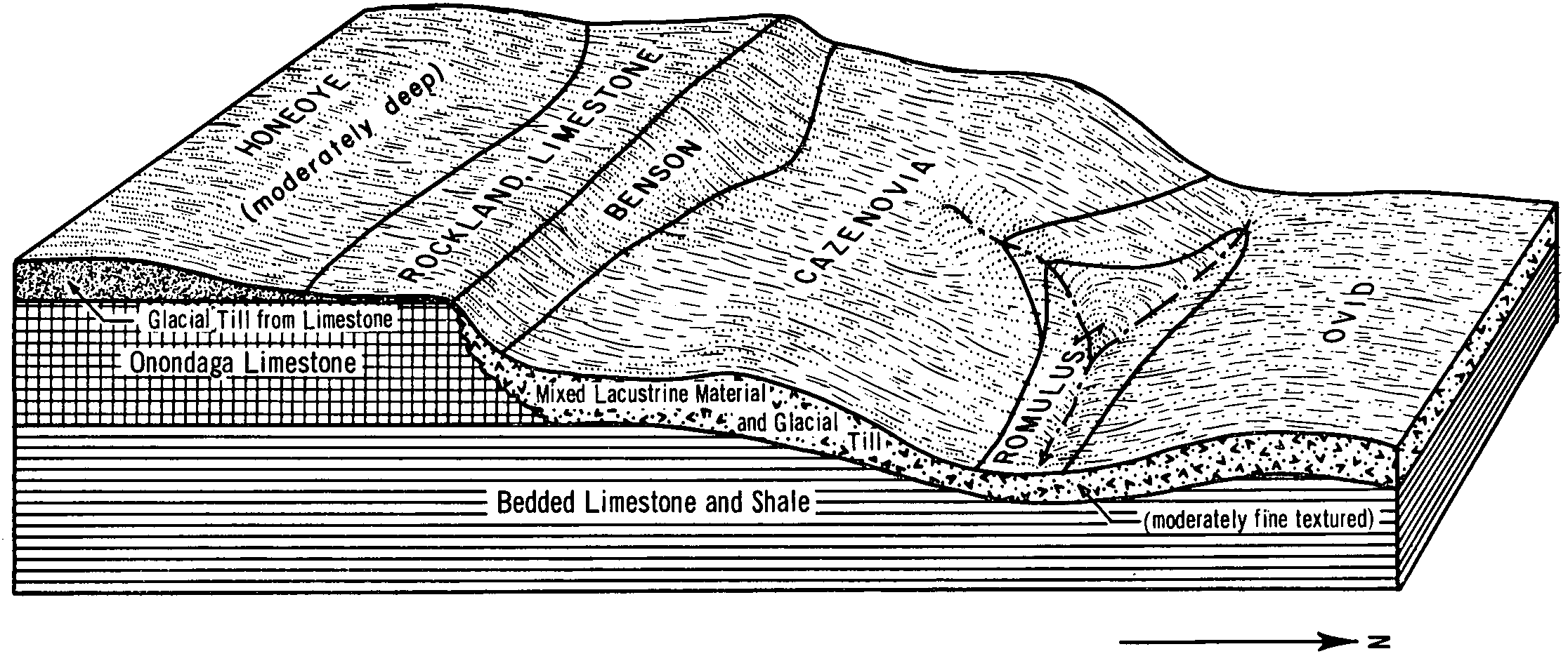
| Cazenovia silt loam, 2 to 8 percent slopes | CeB | 12774 | 289374 | 9q3n | ny011 | 1968 | 1:15840 |
Cazenovia silt loam, 5 to 14 percent slopes, eroded | CeC3 | 2474 | 289376 | 9q3q | ny011 | 1968 | 1:15840 |
Cazenovia silt loam, rolling | CeCK | 1657 | 289377 | 9q3r | ny011 | 1968 | 1:15840 |
Cazenovia silt loam, 12 to 20 percent slopes | CeD | 1135 | 289378 | 9q3s | ny011 | 1968 | 1:15840 |
Cazenovia and Schoharie soils, 20 to 40 percent slopes | ChE | 842 | 289380 | 2xghg | ny011 | 1968 | 1:15840 |
Cazenovia silt loam, 8 to 14 percent slopes | CeC | 684 | 289375 | 9q3p | ny011 | 1968 | 1:15840 |
Urban land-Cazenovia complex, 2 to 8 percent slopes | Uc | 483 | 601046 | n5fl | ny011 | 1968 | 1:15840 |
Cazenovia silt loam, 8 to 15 percent slopes | CnC | 2348 | 290320 | 9r35 | ny021 | 1985 | 1:15840 |
Cazenovia silt loam, 3 to 8 percent slopes | CnB | 1653 | 290319 | 9r34 | ny021 | 1985 | 1:15840 |
Cazenovia silt loam, 15 to 25 percent slopes | CnD | 1152 | 290321 | 9r36 | ny021 | 1985 | 1:15840 |
Cazenovia silt loam, 3 to 8 percent slopes | CgB | 3151 | 290767 | 9rkl | ny029 | 1979 | 1:15840 |
Cazenovia silt loam, 8 to 15 percent slopes | CgC | 222 | 290768 | 9rkm | ny029 | 1979 | 1:15840 |
Cazenovia silt loam, 3 to 8 percent slopes | CeB | 4586 | 301681 | b3xn | ny037 | 2004 | 1:24000 |
Cazenovia silt loam, 0 to 3 percent slopes | CeA | 853 | 301680 | b3xm | ny037 | 2004 | 1:24000 |
Cazenovia silt loam, 8 to 15 percent slopes | CeC | 838 | 301682 | b3xp | ny037 | 2004 | 1:24000 |
Cazenovia silty clay loam, 8 to 15 percent slopes, eroded | CgC3 | 180 | 301683 | b3xq | ny037 | 2004 | 1:24000 |
Cazenovia silty clay loam, 15 to 25 percent slopes, eroded | CgD3 | 154 | 301684 | b3xr | ny037 | 2004 | 1:24000 |
Cazenovia silt loam, 3 to 8 percent slopes | 55B | 3374 | 3112848 | 2yfvl | ny051 | 2019 | 1:24000 |
Cazenovia silt loam, 8 to 15 percent slopes | 55C | 764 | 3112849 | 2yfvm | ny051 | 2019 | 1:24000 |
Cazenovia silt loam, 15 to 25 percent slopes | 55D | 333 | 3112850 | 2yfvn | ny051 | 2019 | 1:24000 |
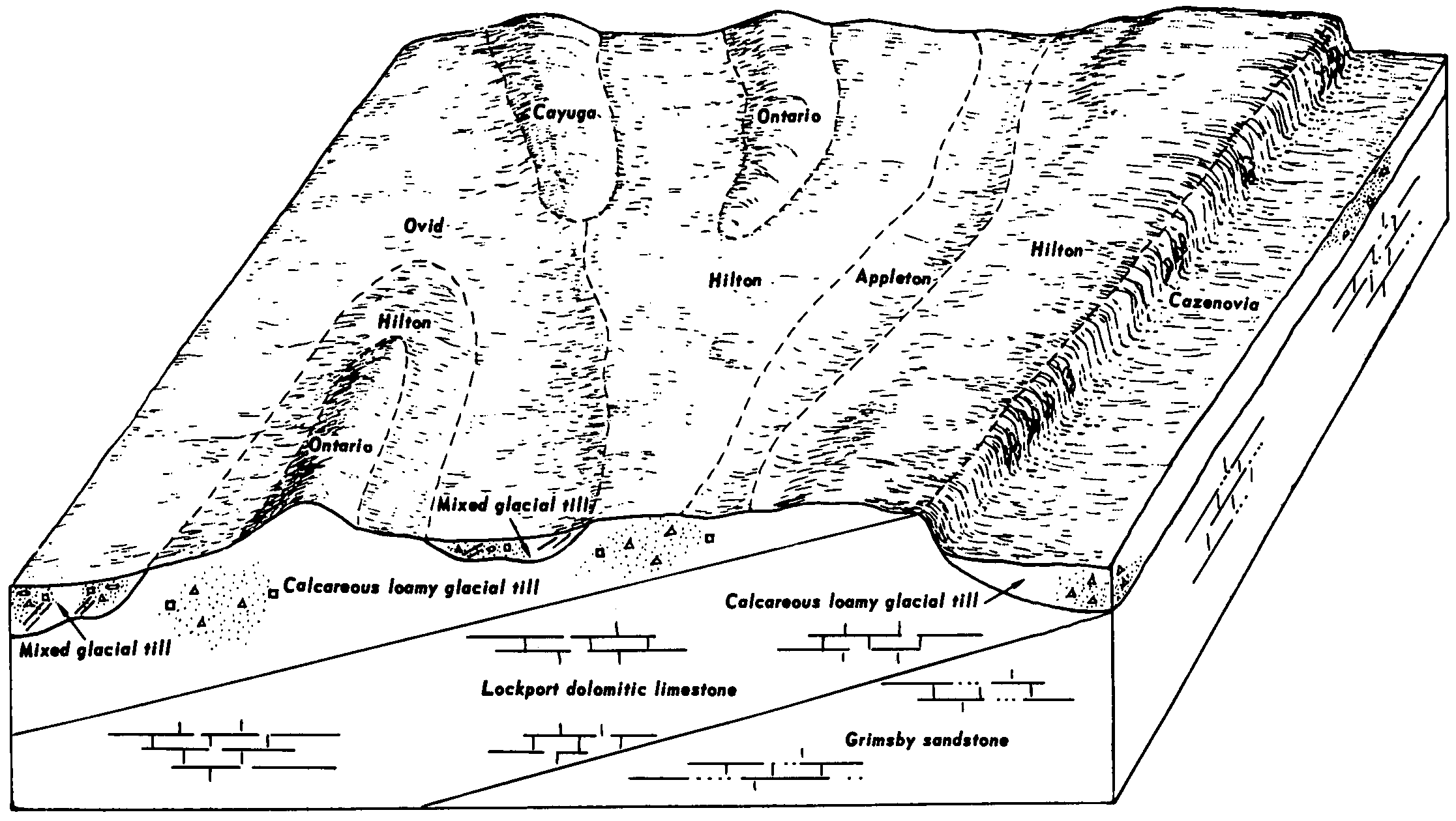
Cazenovia silt loam, 3 to 8 percent slopes | CfB | 6534 | 292533 | 9tdk | ny053 | 1975 | 1:15840 |
Cazenovia silt loam, 8 to 15 percent slopes | CfC | 4677 | 292534 | 9tdl | ny053 | 1975 | 1:15840 |
Cazenovia silt loam, 15 to 25 percent slopes | CfD | 2539 | 292536 | 9tdn | ny053 | 1975 | 1:15840 |
Schoharie-Cazenovia complex, 25 to 50 percent slopes | SEE | 2249 | 292630 | 2xggz | ny053 | 1975 | 1:15840 |
Cazenovia silt loam, 8 to 15 percent slopes, severely e roded | CfC3 | 619 | 292535 | 9tdm | ny053 | 1975 | 1:15840 |
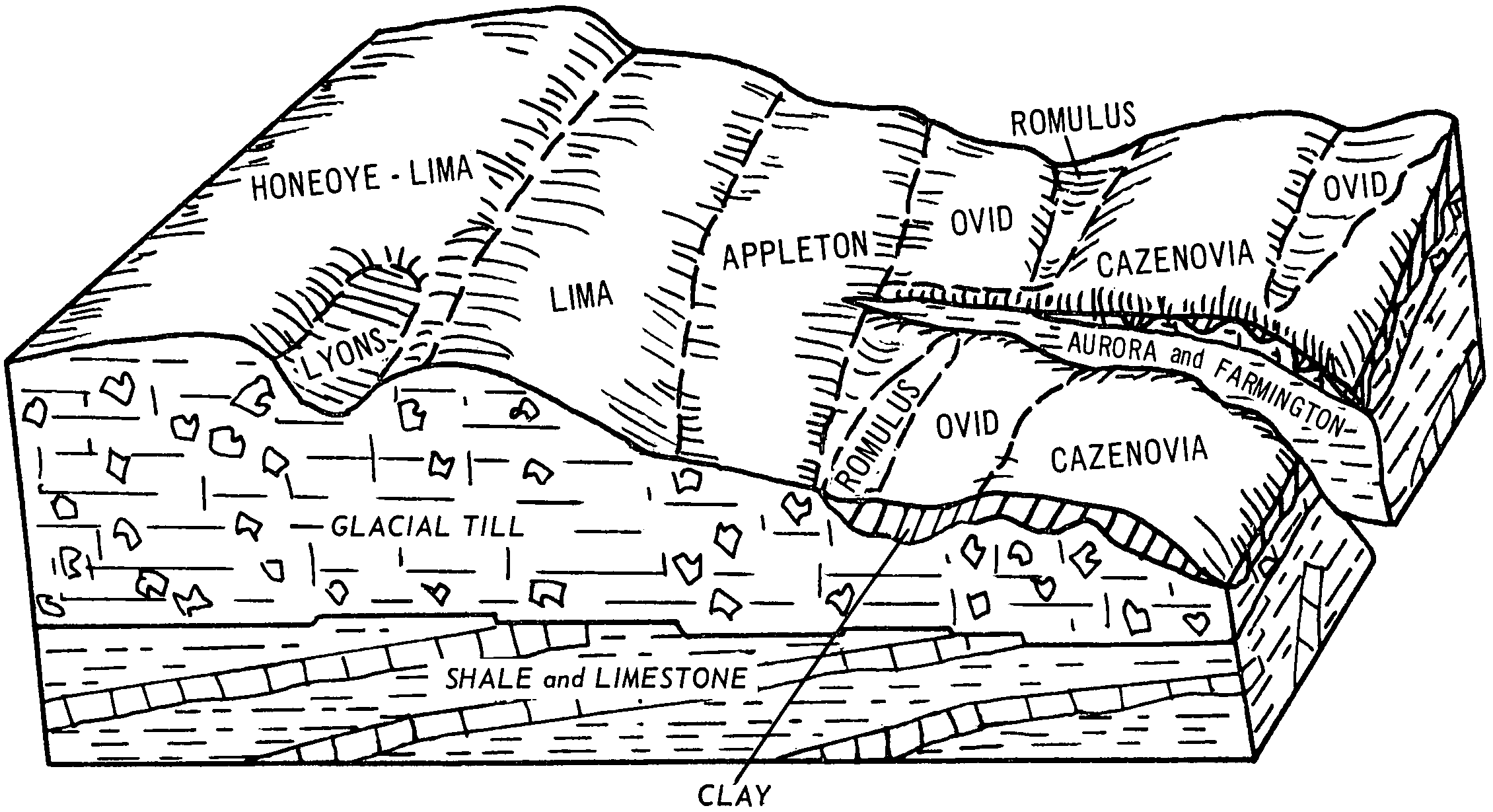
Lima and Cazenovia soils, 0 to 6 percent slopes, bedrock substratum phase | LoB | 4937 | 292723 | 2w3kg | ny055 | 1967 | 1:15840 |
Cazenovia gravelly loam, 0 to 3 percent slopes | CgA | 4671 | 292674 | 9tk3 | ny055 | 1967 | 1:15840 |
Cazenovia gravelly loam, 3 to 8 percent slopes | CgB | 3016 | 292675 | 9tk4 | ny055 | 1967 | 1:15840 |
Hilton-Cazenovia complex, 3 to 8 percent slopes, stony | HmB | 680 | 292709 | 2w3l2 | ny055 | 1967 | 1:15840 |
Hilton-Cazenovia complex, 0 to 3 percent slopes, stony | HmA | 241 | 292708 | 2w3l1 | ny055 | 1967 | 1:15840 |
Cazenovia silt loam, 3 to 8 percent slopes | 109B | 17726 | 293298 | 9v67 | ny065 | 1993 | 1:24000 |
Cazenovia silt loam, 8 to 15 percent slopes | 109C | 4920 | 293299 | 9v68 | ny065 | 1993 | 1:24000 |
Honeoye and Cazenovia soils, 25 to 45 percent slopes | 104E | 3529 | 293297 | 2w3pb | ny065 | 1993 | 1:24000 |
Cazenovia silt loam, 15 to 25 percent slopes | 109D | 1642 | 293300 | 9v69 | ny065 | 1993 | 1:24000 |
Cazenovia silt loam, 2 to 8 percent slopes | CfB | 7189 | 293544 | 9vg5 | ny067 | 1973 | 1:20000 |
Cazenovia silt loam, 8 to 15 percent slopes | CfC | 3912 | 293545 | 9vg6 | ny067 | 1973 | 1:20000 |
Cazenovia soils, 15 to 25 percent slopes | CgD | 2118 | 293547 | 9vg8 | ny067 | 1973 | 1:20000 |
Cazenovia silt loam, 8 to 15 percent slopes, eroded | CfC2 | 824 | 293546 | 9vg7 | ny067 | 1973 | 1:20000 |
Cazenovia silt loam, 3 to 8 percent slopes | 255B | 1082 | 2421603 | 2m8w7 | ny069 | 2012 | 1:12000 |
Cazenovia silt loam, 8 to 15 percent slopes | 255C | 243 | 2421602 | 2m8w6 | ny069 | 2012 | 1:12000 |
Cazenovia silt loam, 15 to 25 percent slopes | 255D | 67 | 2512745 | 2q6br | ny069 | 2012 | 1:12000 |
Cazenovia silt loam, 3 to 8 percent slopes | CeB | 3385 | 294010 | 9vy6 | ny073 | 1973 | 1:15840 |
Hilton-Cazenovia complex, 0 to 8 percent slopes, stony | HnB | 2242 | 294039 | 2w3l3 | ny073 | 1973 | 1:15840 |
Cazenovia gravelly silt loam, shale substratum, 3 to 8 percent slopes | CfB | 2098 | 294013 | 9vy9 | ny073 | 1973 | 1:15840 |
Cazenovia gravelly silt loam, shale substratum, 0 to 3 percent slopes | CfA | 703 | 294012 | 9vy8 | ny073 | 1973 | 1:15840 |
Cazenovia silt loam, 0 to 3 percent slopes | CeA | 349 | 294009 | 9vy5 | ny073 | 1973 | 1:15840 |
Darien-Danley-Cazenovia silt loams, 3 to 8 percent slopes | DdB | 11950 | 294709 | 9wnr | ny099 | 1966 | 1:15840 |
Cazenovia silt loam, 3 to 8 percent slopes | CeB | 9835 | 294691 | 9wn5 | ny099 | 1966 | 1:15840 |
Cazenovia silt loam, 8 to 15 percent slopes, eroded | CeC3 | 1335 | 294694 | 9wn8 | ny099 | 1966 | 1:15840 |
Cazenovia silt loam, 8 to 15 percent slopes | CeC | 936 | 294693 | 9wn7 | ny099 | 1966 | 1:15840 |
Cazenovia soils, 15 to 25 percent slopes | ChD | 383 | 294695 | 9wn9 | ny099 | 1966 | 1:15840 |
Cazenovia soils, 25 to 40 percent slopes | ChE | 269 | 294696 | 9wnb | ny099 | 1966 | 1:15840 |
Cazenovia silt loam, 3 to 8 percent slopes, eroded | CeB3 | 74 | 294692 | 9wn6 | ny099 | 1966 | 1:15840 |
Cazenovia silt loam, 3 to 8 percent slopes | CeB | 1638 | 295709 | 9xq0 | ny117 | 1972 | 1:15840 |
Cazenovia gravelly silt loam, bedrock substratum, 3 to 8 percent slopes | CoB | 1258 | 295712 | 9xq3 | ny117 | 1972 | 1:15840 |
Cazenovia gravelly silt loam, bedrock substratum, 0 to 3 percent slopes | CoA | 679 | 295711 | 9xq2 | ny117 | 1972 | 1:15840 |
Cazenovia silt loam, 8 to 15 percent slopes | CeC | 350 | 295710 | 9xq1 | ny117 | 1972 | 1:15840 |
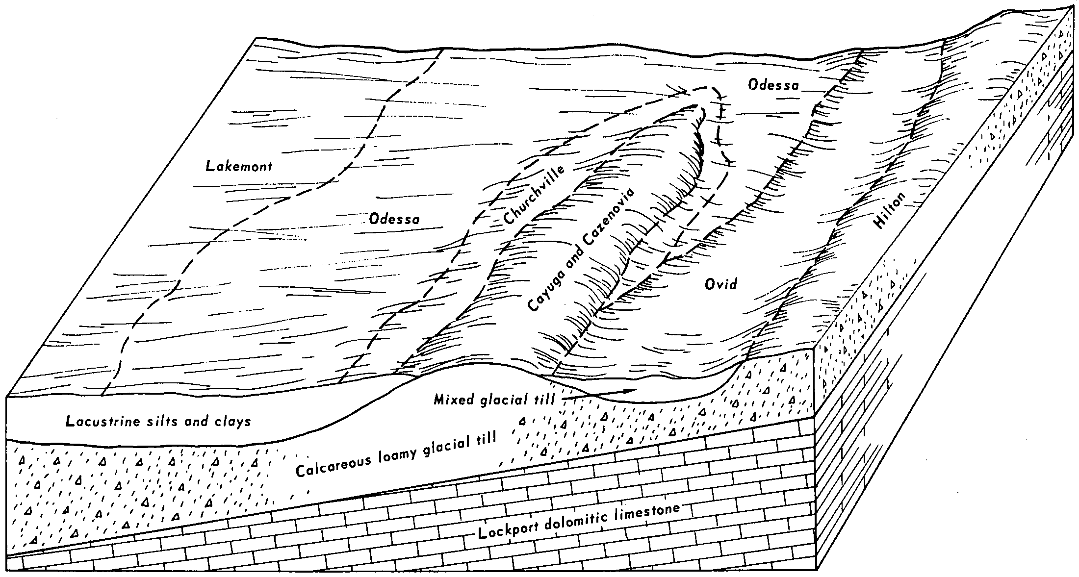
Cayuga and Cazenovia silt loams, 2 to 6 percent slopes | CcB | 3245 | 292973 | 9tvr | ny664 | 1968 | 1:15840 |
Cayuga and Cazenovia silt loams, 0 to 2 percent slopes | CcA | 664 | 292972 | 9tvq | ny664 | 1968 | 1:15840 |
Cazenovia gravelly silt loam, shale substratum, 0 to 3 percent slopes | CgA | 533 | 292977 | 9tvw | ny664 | 1968 | 1:15840 |
Cayuga and Cazenovia silt loams, 6 to 12 percent slopes | CcC | 461 | 292974 | 9tvs | ny664 | 1968 | 1:15840 |
Cazenovia gravelly silt loam, shale substratum, 3 to 8 percent slopes | CgB | 402 | 292978 | 9tvx | ny664 | 1968 | 1:15840 |
Cazenovia gravelly silt loam, 3 to 8 percent slopes | CeB | 287 | 292976 | 9tvv | ny664 | 1968 | 1:15840 |
Cazenovia gravelly silt loam, 0 to 3 percent slopes | CeA | 182 | 292975 | 9tvt | ny664 | 1968 | 1:15840 |


