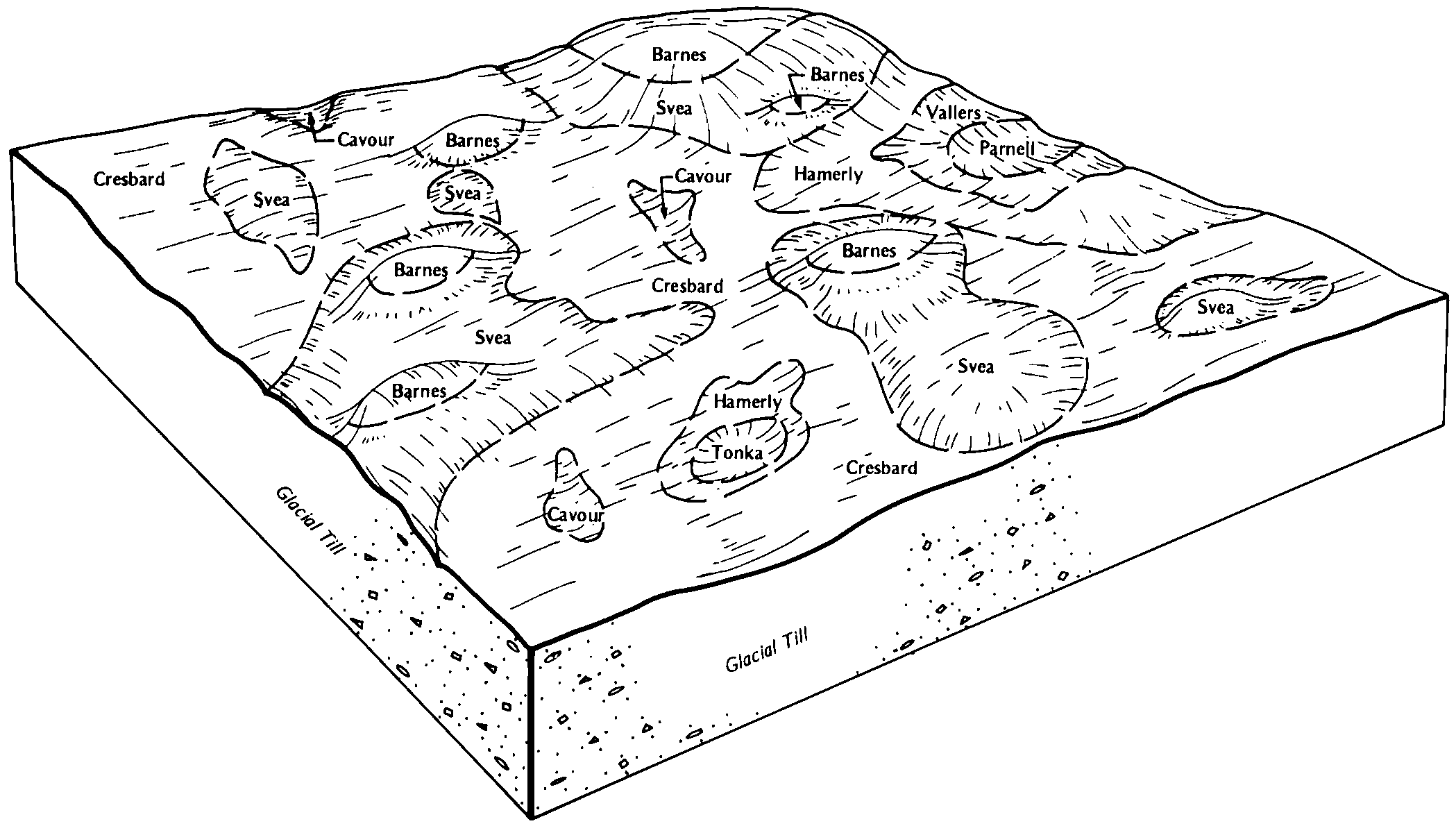
| Svea-Cavour loams, 0 to 3 percent slopes | G123A | 19740 | 2573670 | 2q61d | nd003 | 1988 | 1:20000 |
Barnes-Cavour loams, 3 to 6 percent slopes | G123B | 1796 | 2573671 | 2q61f | nd003 | 1988 | 1:20000 |
Cavour-Ferney loams, 3 to 6 percent slopes | F129B | 1018 | 2587678 | 2q4gl | nd005 | | 1:12000 |
Cresbard-Cavour loams, 0 to 3 percent slopes | G124A | 170 | 2573740 | 2pwzd | nd005 | | 1:12000 |
Cavour-Ferney loams, 0 to 3 percent slopes | G129A | 81 | 2573766 | 2q4nt | nd005 | | 1:12000 |
Cavour-Cresbard loams, 0 to 3 percent slopes | G125A | 314 | 2575165 | 2pwzf | nd017 | 1983 | 1:20000 |
Cavour-Cresbard loams, 0 to 3 percent slopes | F125A | 30059 | 2587522 | 2q4gh | nd019 | 1987 | 1:20000 |
Ferney-Cavour loams, 0 to 3 percent slopes | F128A | 3858 | 2587523 | 2q4gk | nd019 | 1987 | 1:20000 |
Barnes-Cavour loams, 3 to 6 percent slopes | G123B | 27573 | 2575383 | 2q61f | nd021 | 1989 | 1:20000 |
Cavour-Ferney loams, 0 to 3 percent slopes | G129A | 24699 | 2575286 | 2q4nt | nd021 | 1989 | 1:20000 |
Forman-Cavour loams, 0 to 3 percent slopes | G138A | 14992 | 2575287 | 2q4nw | nd021 | 1989 | 1:20000 |
Svea-Cavour loams, 0 to 3 percent slopes | G123A | 12997 | 2575382 | 2q61d | nd021 | 1989 | 1:20000 |
Ferney-Cavour loams, 0 to 3 percent slopes | G128A | 3803 | 2575258 | 2pwzg | nd021 | 1989 | 1:20000 |
Cresbard-Cavour loams, 3 to 6 percent slopes | G124B | 41 | 2575285 | 2q4ns | nd021 | 1989 | 1:20000 |
Cresbard-Cavour loams, 0 to 3 percent slopes | G124A | 10 | 2575257 | 2pwzd | nd021 | 1989 | 1:20000 |
Cresbard-Cavour loams, 0 to 3 percent slopes | G124A | 63 | 2575397 | 2pwzd | nd027 | | 1:12000 |
Ferney-Cavour loams, 0 to 3 percent slopes | G128A | 11 | 2575398 | 2pwzg | nd027 | | 1:12000 |
Cavour-Cresbard loams, 0 to 3 percent slopes | G125A | 341 | 2576374 | 2pwzf | nd031 | 1990 | 1:20000 |
Ferney-Cavour loams, 0 to 3 percent slopes | G128A | 184 | 2576375 | 2pwzg | nd031 | 1990 | 1:20000 |
Cresbard-Cavour loams, 0 to 3 percent slopes | G124A | 18087 | 2576507 | 2pwzd | nd035 | 1980 | 1:20000 |
Cavour-Ferney loams, 0 to 3 percent slopes | G129A | 3167 | 2576516 | 2q4nt | nd035 | 1980 | 1:20000 |
Cavour-Cresbard loams, 0 to 3 percent slopes | G125A | 117 | 2576547 | 2pwzf | nd035 | 1980 | 1:20000 |
Ferney-Cavour loams, 0 to 3 percent slopes | F128A | 50 | 2587483 | 2q4gk | nd035 | 1980 | 1:20000 |
Cavour-Ferney loams, 3 to 6 percent slopes | F129B | 15 | 2587467 | 2q4gl | nd035 | 1980 | 1:20000 |
Ferney-Cavour loams, 0 to 3 percent slopes | G128A | 9 | 2576485 | 2pwzg | nd035 | 1980 | 1:20000 |
Cavour-Cresbard loams, 0 to 3 percent slopes | G125A | 4000 | 2576560 | 2pwzf | nd039 | 1991 | 1:24000 |
Ferney-Cavour loams, 0 to 3 percent slopes | G128A | 3856 | 2576561 | 2pwzg | nd039 | 1991 | 1:24000 |
Cresbard-Cavour loams, 0 to 3 percent slopes | G124A | 1778 | 2577019 | 2pwzd | nd045 | 1966 | 1:20000 |
Cavour-Cresbard loams, 0 to 3 percent slopes | G125A | 1037 | 2577020 | 2pwzf | nd045 | 1966 | 1:20000 |
Cavour-Ferney loams, 0 to 3 percent slopes | G129A | 985 | 2577050 | 2q4nt | nd045 | 1966 | 1:20000 |
Svea-Cavour loams, 0 to 3 percent slopes | G123A | 60 | 2577135 | 2q61d | nd045 | 1966 | 1:20000 |
Barnes-Cavour loams, 3 to 6 percent slopes | G123B | 39 | 2577136 | 2q61f | nd045 | 1966 | 1:20000 |
Ferney-Cavour loams, 0 to 3 percent slopes | G128A | 25 | 2577021 | 2pwzg | nd045 | 1966 | 1:20000 |
Cavour-Cresbard loams, 0 to 3 percent slopes | G125A | 8032 | 2571326 | 2pwzf | nd049 | 1987 | 1:20000 |
Ferney-Cavour loams, 0 to 3 percent slopes | G128A | 6077 | 2571327 | 2pwzg | nd049 | 1987 | 1:20000 |
Cavour-Cresbard loams, 0 to 3 percent slopes | F125A | 152 | 2585590 | 2q4gh | nd049 | 1987 | 1:20000 |
Ferney-Cavour loams, 0 to 3 percent slopes | F128A | 80 | 2585756 | 2q4gk | nd049 | 1987 | 1:20000 |
Cresbard-Cavour loams, 0 to 3 percent slopes | G124A | 7 | 2571325 | 2pwzd | nd049 | 1987 | 1:20000 |
Ferney-Cavour loams, 0 to 3 percent slopes | G128A | 30 | 2577143 | 2pwzg | nd055 | 1974 | 1:20000 |
Cavour-Cresbard loams, 0 to 3 percent slopes | G125A | 3128 | 2577243 | 2pwzf | nd063 | | 1:12000 |
Ferney-Cavour loams, 0 to 3 percent slopes | G128A | 1795 | 2577244 | 2pwzg | nd063 | | 1:12000 |
Cavour-Cresbard loams, 0 to 3 percent slopes | F125A | 772 | 2587314 | 2q4gh | nd063 | | 1:12000 |
Cresbard-Cavour loams, 0 to 3 percent slopes | G124A | 487 | 2577242 | 2pwzd | nd063 | | 1:12000 |
Ferney-Cavour loams, 0 to 3 percent slopes | F128A | 295 | 2587368 | 2q4gk | nd063 | | 1:12000 |
Cresbard-Cavour loams, 0 to 3 percent slopes | G124A | 52 | 2581114 | 2pwzd | nd073 | 1992 | 1:20000 |
Svea-Cavour loams, 0 to 3 percent slopes | G123A | 10 | 2581223 | 2q61d | nd073 | 1992 | 1:20000 |
Cavour-Cresbard loams, 0 to 3 percent slopes | F125A | 254 | 2585338 | 2q4gh | nd075 | 1972 | 1:20000 |
Cavour-Cresbard loams, 0 to 3 percent slopes | F125A | 1795 | 2588012 | 2q4gh | nd079 | 1990 | 1:24000 |
Ferney-Cavour loams, 0 to 3 percent slopes | F128A | 1413 | 2588182 | 2q4gk | nd079 | 1990 | 1:24000 |
Cavour-Cresbard loams, 3 to 6 pecent slopes | F125B | 965 | 2588163 | 2q4gj | nd079 | 1990 | 1:24000 |
Ferney-Cavour loams, 0 to 3 percent slopes | G128A | 4 | 2579441 | 2pwzg | nd081 | 1959 | 1:12000 |
Cresbard-Cavour loams, 0 to 3 percent slopes | G124A | 559 | 2581929 | 2pwzd | nd083 | 1990 | 1:20000 |
Ferney-Cavour loams, 0 to 3 percent slopes | G128A | 355 | 2581931 | 2pwzg | nd083 | 1990 | 1:20000 |
Cavour-Cresbard loams, 0 to 3 percent slopes | G125A | 180 | 2581930 | 2pwzf | nd083 | 1990 | 1:20000 |
Cresbard-Cavour loams, 3 to 6 percent slopes | G124B | 143 | 2581963 | 2q4ns | nd083 | 1990 | 1:20000 |
Cavour-Cresbard loams, 0 to 3 percent slopes | G125A | 953 | 2579715 | 2pwzf | nd091 | 1991 | 1:20000 |
Ferney-Cavour loams, 0 to 3 percent slopes | G128A | 643 | 2579716 | 2pwzg | nd091 | 1991 | 1:20000 |
Cresbard-Cavour loams, 0 to 3 percent slopes | G124A | 37 | 2579714 | 2pwzd | nd091 | 1991 | 1:20000 |
Cresbard-Cavour loams, 0 to 3 percent slopes | G124A | 3707 | 2581325 | 2pwzd | nd093 | 1990 | 1:24000 |
Cavour-Ferney loams, 0 to 3 percent slopes | G129A | 1820 | 2581352 | 2q4nt | nd093 | 1990 | 1:24000 |
Cavour-Cresbard loams, 0 to 3 percent slopes | F125A | 166 | 2586116 | 2q4gh | nd099 | 1967 | 1:20000 |
Cavour-Cresbard loams, 0 to 3 percent slopes | F125A | 236 | 2585120 | 2q4gh | nd101 | 1967 | 1:20000 |
Cavour-Cresbard loams, 0 to 3 percent slopes | G125A | 150 | 2573492 | 2pwzf | nd101 | 1967 | 1:20000 |
Cavour-Ferney loams, 3 to 6 percent slopes | F129B | 24 | 2585182 | 2q4gl | nd101 | 1967 | 1:20000 |
Cavour-Ferney loams, 0 to 3 percent slopes | G129A | 12 | 2573465 | 2q4nt | nd101 | 1967 | 1:20000 |
Cresbard-Cavour loams, 0 to 3 percent slopes | G124A | 194 | 2579588 | 2pwzd | nd103 | 1966 | 1:12000 |
Svea-Cavour loams, 0 to 3 percent slopes | G123A | 79 | 2579698 | 2q61d | nd103 | 1966 | 1:12000 |
Cavour-Ferney loams, 0 to 3 percent slopes | G129A | 31 | 2579625 | 2q4nt | nd103 | 1966 | 1:12000 |
Ferney-Cavour loams, 0 to 3 percent slopes | G128A | 11 | 2579589 | 2pwzg | nd103 | 1966 | 1:12000 |
Hamerly-Cavour-Badger complex, 0 to 2 percent slopes | Hc | 416 | 418764 | g1rj | sd011 | 1995 | 1:24000 |
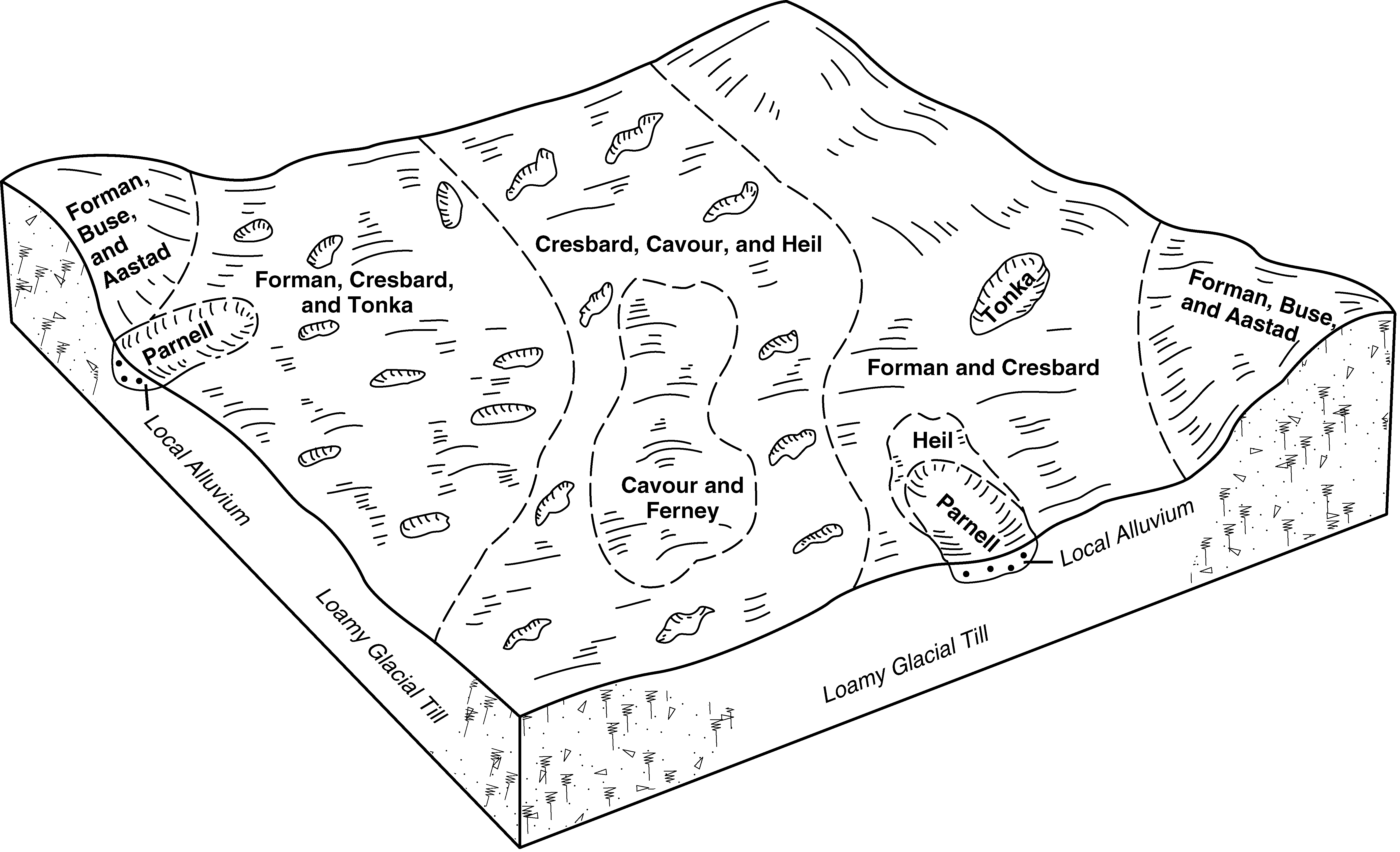
Cresbard-Cavour-Forman loams, 0 to 6 percent slopes | G141B | 16694 | 2797726 | 2sd13 | sd013 | 1987 | 1:20000 |
Cavour-Ferney loams, 0 to 3 percent slopes | G129A | 7866 | 2797657 | 2q4nt | sd013 | 1987 | 1:20000 |
Cresbard-Cavour-Ferney loams, 0 to 3 percent slopes | G130A | 6698 | 2797718 | 2sd0q | sd013 | 1987 | 1:20000 |
Cresbard-Cavour loams, 0 to 3 percent slopes | G124A | 2795 | 2765627 | 2pwzd | sd013 | 1987 | 1:20000 |
Cavour-Cresbard loams, 0 to 3 percent slopes | G125A | 2612 | 2765628 | 2pwzf | sd013 | 1987 | 1:20000 |
Barnes-Cavour loams, 3 to 6 percent slopes | G123B | 1969 | 2797713 | 2q61f | sd013 | 1987 | 1:20000 |
Svea-Cavour loams, 0 to 3 percent slopes | G123A | 675 | 2797712 | 2q61d | sd013 | 1987 | 1:20000 |
Cresbard-Cavour loams, 3 to 6 percent slopes | G124B | 66 | 2797656 | 2q4ns | sd013 | 1987 | 1:20000 |
Peever-Cavour complex, 0 to 3 percent slopes | G202A | 58 | 2797743 | 2sd1y | sd013 | 1987 | 1:20000 |
Cresbard-Cavour-Heil complex, 0 to 3 percent slopes | G126A | 54 | 2797716 | 2q5cx | sd013 | 1987 | 1:20000 |
Forman-Cavour loams, 0 to 3 percent slopes | G138A | 49 | 2797658 | 2q4nw | sd013 | 1987 | 1:20000 |
Cresbard-Cavour loams, 0 to 3 percent slopes | G124A | 4126 | 2797959 | 2pwzd | sd025 | 1992 | 1:20000 |
Cavour-Ferney loams, 0 to 3 percent slopes | G129A | 3673 | 2797968 | 2q4nt | sd025 | 1992 | 1:20000 |
Peever-Cavour complex, 0 to 3 percent slopes | G202A | 1956 | 2798006 | 2sd1y | sd025 | 1992 | 1:20000 |
Forman-Cavour loams, 0 to 3 percent slopes | G138A | 196 | 2797969 | 2q4nw | sd025 | 1992 | 1:20000 |
Cresbard-Cavour-Heil complex, 0 to 3 percent slopes | G126A | 92 | 2797989 | 2q5cx | sd025 | 1992 | 1:20000 |
Cavour-Ferney silt loams, 0 to 2 percent slopes | J120A | 557 | 1684451 | 1tjt4 | sd029 | 2006 | 1:12000 |
Cresbard-Cavour loams, 0 to 3 percent slopes | G124A | 1255 | 2798437 | 2pwzd | sd037 | 1992 | 1:20000 |
Cavour-Ferney loams, 0 to 3 percent slopes | G129A | 1152 | 2798450 | 2q4nt | sd037 | 1992 | 1:20000 |
Cavour-Ferney loams | Ca | 4 | 417054 | fzzc | sd037 | 1992 | 1:20000 |
Peever-Cavour clay loams | Pg | 352 | 416888 | fzt0 | sd039 | 1992 | 1:20000 |
Peever-Cavour complex | Pd | 17790 | 418174 | g14h | sd051 | 1977 | 1:20000 |
Cresbard-Cavour loams, 3 to 6 percent slopes | G124B | 4672 | 2798800 | 2q4ns | sd089 | 1980 | 1:20000 |
Cresbard-Cavour-Ferney loams, 0 to 3 percent slopes | G130A | 4119 | 2798829 | 2sd0q | sd089 | 1980 | 1:20000 |
Cavour-Ferney loams, 0 to 3 percent slopes | G129A | 1689 | 2798801 | 2q4nt | sd089 | 1980 | 1:20000 |
Cresbard-Cavour loams, 0 to 3 percent slopes | G124A | 1521 | 2798793 | 2pwzd | sd089 | 1980 | 1:20000 |
Forman-Cavour loams, 0 to 3 percent slopes | G138A | 33 | 2798802 | 2q4nw | sd089 | 1980 | 1:20000 |
Cresbard-Cavour-Forman loams, 0 to 6 percent slopes | G141B | 17 | 2799232 | 2sd13 | sd089 | 1980 | 1:20000 |
Peever-Cavour complex, 0 to 3 percent slopes | PhA | 1655 | 417856 | g0t7 | sd109 | 1977 | 1:20000 |
Cresbard-Cavour-Heil complex, 0 to 3 percent slopes | G126A | 18517 | 2799569 | 2q5cx | sd115 | 1997 | 1:24000 |
Cavour-Ferney loams, 0 to 3 percent slopes | G129A | 16508 | 2799544 | 2q4nt | sd115 | 1997 | 1:24000 |
Cresbard-Cavour loams, 0 to 3 percent slopes | G124A | 11861 | 2799532 | 2pwzd | sd115 | 1997 | 1:24000 |
Peever-Cavour complex, 0 to 3 percent slopes | G202A | 740 | 2799586 | 2sd1y | sd115 | 1997 | 1:24000 |
Forman-Cavour loams, 0 to 3 percent slopes | G138A | 371 | 2799545 | 2q4nw | sd115 | 1997 | 1:24000 |
