| Cathedral family-Rock outcrop complex, 40 to 150 percent slopes | 98 | 352 | 496574 | jnqj | co627 | 1980 | 1:24000 |
Cathedral family, moist-Rock outcrop complex, 40 to 150 percent slopes | 99 | 315 | 496577 | jnqm | co627 | 1980 | 1:24000 |
Cathedral family-Rock outcrop complex, 40 to 150 percent slopes | 51 | 553 | 498423 | jqn5 | co635 | 1979 | 1:24000 |
Cathedral family, moist-Rock outcrop complex, 40 to 150 percent slopes | 52 | 228 | 498424 | jqn6 | co635 | 1979 | 1:24000 |
Cathedral family, moist-Rock outcrop complex, 40 to 150 percent slopes | 709YB | 22309 | 509900 | k3ld | co636 | 2011 | 1:24000 |
Cathedral family-Rock outcrop complex, 40 to 150 percent slopes | 706YB | 13552 | 509894 | k3l6 | co636 | 2011 | 1:24000 |
Cathedral-Rock outcrop complex, 45 to 80 percent slopes | 19 | 13947 | 498282 | jqhm | co637 | 1986 | 1:24000 |
Cathedral very gravelly sandy loam, 15 to 40 percent slopes | 136 | 2843 | 2497275 | 2n84g | co637 | 1986 | 1:24000 |
Cathedral very gravelly sandy loam, cool, 10 to 40 percent slopes | 137 | 667 | 2497276 | 2n846 | co637 | 1986 | 1:24000 |
Cathedral-Rock outcrop complex, 20 to 60 percent slopes | 138 | 299 | 2497290 | 2n842 | co637 | 1986 | 1:24000 |
Cathedral-Rock outcrop complex, 20 to 60 percent slopes | 21 | 17435 | 2450676 | 2n842 | co638 | 2010 | 1:24000 |
Cathedral very gravelly sandy loam, 15 to 40 percent slopes | 19 | 11935 | 2450688 | 2n84g | co638 | 2010 | 1:24000 |
Cathedral very gravelly sandy loam, cool, 10 to 40 percent slopes | 20 | 5141 | 2450680 | 2n846 | co638 | 2010 | 1:24000 |
Cathedral, cool-Rock outcrop complex, 40 to 60 percent slopes | 22 | 3693 | 2450708 | 2n853 | co638 | 2010 | 1:24000 |
Cathedral very gravelly sandy loam, 3 to 15 percent slopes | 18 | 2124 | 507413 | k105 | co638 | 2010 | 1:24000 |
Security-Cathedral complex, 40 to 65 percent slopes, very stony | 40 | 3693 | 497356 | jpjr | co640 | 1984 | 1:24000 |
Security-Cathedral-Rock outcrop complex, 15 to 65 percent slopes, very stony | 41 | 2451 | 497357 | jpjs | co640 | 1984 | 1:24000 |
Rock outcrop-Security-Cathedral complex, 15 to 65 percent slopes | 34 | 2336 | 497349 | jpjj | co640 | 1984 | 1:24000 |
Cathedral gravelly sandy loam, 40 to 65 percent slopes, extremely stony | 8 | 97 | 497371 | jpk7 | co640 | 1984 | 1:24000 |
Ratake-Cathedral-Rock outcrop complex, 25 to 60 percent slopes | 123 | 31084 | 497400 | jpl5 | co641 | 1980 | 1:24000 |
Rock outcrop-Cathedral-Ratake complex, 50 to 100 percent slopes | 140 | 5573 | 497419 | jpls | co641 | 1980 | 1:24000 |
Ratake-Cathedral-Rock outcrop complex, 25 to 60 percent north slopes | 124 | 2057 | 497401 | jpl6 | co641 | 1980 | 1:24000 |
Ratake-Cathedral very stony sandy loams, 25 to 60 percent slopes | 122 | 1511 | 497399 | jpl4 | co641 | 1980 | 1:24000 |
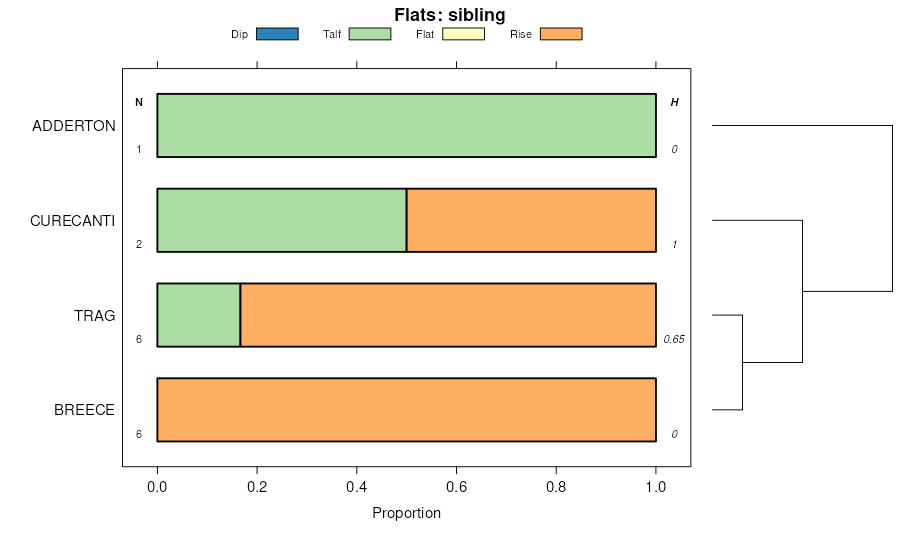
Cathedral-Ratake complex, 5 to 15 percent slopes | 50 | 2434 | 2407113 | 2lsst | co642 | 2012 | 1:24000 |
Cathedral-Ratake complex, 15 to 35 percent slopes | 51 | 1658 | 2407114 | 2lssv | co642 | 2012 | 1:24000 |
Rock outcrop-Cathedral complex, 20 to 100 percent slopes | 32 | 877 | 2407109 | jzyq | co642 | 2012 | 1:24000 |
Typic Haplustolls-Cathedral family-Rock outcrop complex, 40 to 150 percent slopes | 2704D | 474 | 2407120 | tlxl | co642 | 2012 | 1:24000 |
Kutler, very stony-Cathedral, extremely bouldery complex, 20 to 55 percent slopes | 316 | 217 | 3365635 | 312cl | co643 | 1975 | 1:20000 |
Cathedral, extremely bouldery-Kutler, extremely bouldery-Rock outcrop complex, 15 to 55 percent slopes | 306 | 125 | 3365647 | 312dc | co643 | 1975 | 1:20000 |
Boyle-Rock outcrop-Cathedral complex, 5 to 45 percent slopes | 122 | 383 | 497621 | jpt9 | co644 | 1980 | 1:24000 |
Cathedral-Boyle complex, 10 to 30 percent slopes | 123 | 19 | 497622 | jptb | co644 | 1980 | 1:24000 |
Ratake-Cathedral families-Rock outcrop complex, 40 to 150 percent slopes | 2705D | 32329 | 762961 | tlxn | co645 | | 1:24000 |
Typic Haplustolls-Cathedral family-Rock outcrop complex, 40 to 150 percent slopes | 2704D | 31514 | 762959 | tlxl | co645 | | 1:24000 |
Cathedral family-Rock outcrop complex, 40 to 150 percent slopes | 2702D | 8553 | 762957 | tlxj | co645 | | 1:24000 |
Kutler, very stony-Cathedral, extremely bouldery complex, 20 to 55 percent slopes | 316 | 617 | 3365672 | 312cl | co645 | | 1:24000 |
Cathedral, extremely bouldery-Kutler, extremely bouldery-Rock outcrop complex, 15 to 55 percent slopes | 306 | 333 | 3365677 | 312dc | co645 | | 1:24000 |
Rock outcrop-Cathedral complex, 20 to 100 percent slopes | 32 | 203 | 2658581 | jzyq | co645 | | 1:24000 |
Cathedral-Ratake complex, 5 to 15 percent slopes | 50 | 102 | 2658582 | 2lsst | co645 | | 1:24000 |
Cathedral-Ratake complex, 15 to 35 percent slopes | 51 | 1 | 2658583 | 2lssv | co645 | | 1:24000 |
Rock outcrop-Cathedral complex, 20 to 100 percent slopes | 32 | 2189 | 506407 | jzyq | co651 | 1999 | 1:24000 |
Cathedral-Ratake complex, 5 to 15 percent slopes | 50 | 86 | 2658574 | 2lsst | co651 | 1999 | 1:24000 |
Cathedral-Ratake complex, 15 to 35 percent slopes | 51 | 36 | 2658575 | 2lssv | co651 | 1999 | 1:24000 |
Cathedral-Rock outcrop complex, 30 to 70 percent slopes | 5 | 7279 | 512676 | k6gy | co653 | 2000 | 1:24000 |
Resort-Cathedral-Rubble land complex, 30 to 60 percent slopes | 48 | 6958 | 512720 | k6jc | co653 | 2000 | 1:24000 |
Rock outcrop-Cathedral-Resort complex, 30 to 70 percent slopes | 50 | 4202 | 512722 | k6jf | co653 | 2000 | 1:24000 |
Rock outcrop-Rubble land-Cathedral complex, 40 to 100 percent slopes | 53 | 1836 | 512725 | k6jj | co653 | 2000 | 1:24000 |
Resort-Cathedral complex, 30 to 60 percent slopes | 47 | 1565 | 512719 | k6jb | co653 | 2000 | 1:24000 |
Cathedral-Rock outcrop complex, 5 to 30 percent slopes | 4 | 398 | 512677 | k6gz | co653 | 2000 | 1:24000 |
Rock outcrop-Rubble land-Cathedral complex, 15 to 40 percent slopes | 52 | 173 | 512724 | k6jh | co653 | 2000 | 1:24000 |
Security-Cathedral families complex, 5 to 40 percent slopes | 798M | 6667 | 500838 | jt52 | co657 | | 1:24000 |
Cathedral-Security families-Rock outcrop complex, 40 to 80 percent slopes | 798Y | 6486 | 500839 | jt53 | co657 | | 1:24000 |
Cathedral family-Rock outcrop complex, 40 to 80 percent slopes | 709Y | 3758 | 500813 | jt48 | co657 | | 1:24000 |
Cathedral family, dry-Rock outcrop complex, 40 to 80 percent slopes | 706Y | 1698 | 500811 | jt46 | co657 | | 1:24000 |
Kezar-Cathedral gravelly sandy loams, 5 to 35 percent slopes | KcE | 24701 | 498211 | jqfb | co662 | 1968 | 1:24000 |
Rock outcrop-Cathedral-Argiborolls complex, 15 to 60 percent slopes | 163 | 2611 | 2453709 | 2nc8x | co664 | 1987 | 1:24000 |
Cathedral-Veatch complex, 25 to 85 percent slopes | 17 | 17387 | 496676 | jntt | co682 | 1986 | 1:24000 |
Cathedral-Posant-Rock outcrop complex, 25 to 60 percent slopes | 345 | 1975 | 483869 | j7hp | ut634 | 1997 | 1:24000 |
Rock outcrop-Cathedral complex, 20 to 40 percent slopes | 219 | 37524 | 104573 | 3htb | wy031 | 1998 | 1:24000 |
Rock outcrop-Cathedral-Alderon complex, 25 to 50 percent slopes | 220 | 9141 | 104574 | 3htc | wy031 | 1998 | 1:24000 |
Cathedral-Spinekop-Rock outcrop complex, 0 to 40 percent slopes | 123 | 6283 | 104480 | 3hqb | wy031 | 1998 | 1:24000 |
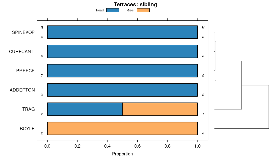
Boyle, thin solum-Breece-Cathedral complex, 0 to 30 percent slopes | 115 | 796 | 104425 | 3hnk | wy031 | 1998 | 1:24000 |
Boyle-Rock outcrop-Cathedral complex, 5 to 45 percent slopes | 118 | 681 | 104426 | 3hnl | wy031 | 1998 | 1:24000 |
Rock outcrop-Cathedral complex, 20 to 40 percent slopes | 212 | 82953 | 501763 | jv3x | wy601 | 1991 | 1:24000 |
Rock outcrop-Cathedral-Alderon complex, 25 to 50 percent slopes | 213 | 28768 | 501765 | jv3z | wy601 | 1991 | 1:24000 |
Cathedral-Spinekop-Rock outcrop complex, 0 to 40 percent slopes | 137 | 14550 | 501673 | jv10 | wy601 | 1991 | 1:24000 |
Boyle-Alderon-Cathedral gravelly sandy loams, 5 to 25 percent slopes | 122 | 12995 | 501652 | jv0b | wy601 | 1991 | 1:24000 |
Rock outcrop-Cathedral complex, 10 to 75 percent slopes | 218 | 59832 | 1669725 | 1t1h3 | wy609 | 2006 | 1:24000 |
Cathedral-Rock outcrop complex, wooded, 6 to 75 percent slopes | 120 | 28537 | 1669787 | 1t1k3 | wy609 | 2006 | 1:24000 |
Rock outcrop-Cathedral, dry complex, 10 to 50 percent slopes | 220 | 147 | 1669796 | 1t1kd | wy609 | 2006 | 1:24000 |
Rock outcrop-Cathedral complex, 20 to 40 percent slopes | 219 | 138 | 1669797 | 1t1kf | wy609 | 2006 | 1:24000 |
Cathedral, very stony-Rock outcrop complex, 25 to 60 percent slopes | 227CK | 49544 | 708654 | rsdt | wy622 | | 1:24000 |
Security family, stony-Cathedral, very stony-Rock outcrop complex, 25 to 60 percent slopes | 240CK | 20617 | 708657 | rsdx | wy622 | | 1:24000 |
Cathedral-Boyle family, moist-Argic Cryaquolls association, 5 to 25 percent slopes | 702B | 5547 | 708667 | rsf7 | wy622 | | 1:24000 |
Ratake family, very stony-Rock outcrop-Cathedral, very stony complex, 5 to 35 percent slopes | 228BK | 5389 | 708653 | rsds | wy622 | | 1:24000 |
Rock outcrop-Cathedral complex, 10 to 50 percent slopes | 255 | 43757 | 502391 | jvs5 | wy625 | 1985 | 1:24000 |
Rock outcrop-Cathedral complex, 20 to 40 percent slopes | 167 | 17776 | 104968 | 3j72 | wy721 | 1994 | 1:24000 |
Boyle-Rock outcrop-Cathedral complex, 5 to 45 percent slopes | 117 | 11160 | 104918 | 3j5g | wy721 | 1994 | 1:24000 |
Cathedral-Boyle complex, 10 to 30 percent slopes | 123 | 7201 | 104924 | 3j5n | wy721 | 1994 | 1:24000 |
Boyle, thin solum-Breece-Cathedral complex, 0 to 30 percent slopes | 114 | 5414 | 104915 | 3j5c | wy721 | 1994 | 1:24000 |
Boyle-Alderon-Cathedral complex, 5 to 45 percent slopes | 112 | 5408 | 104913 | 3j59 | wy721 | 1994 | 1:24000 |