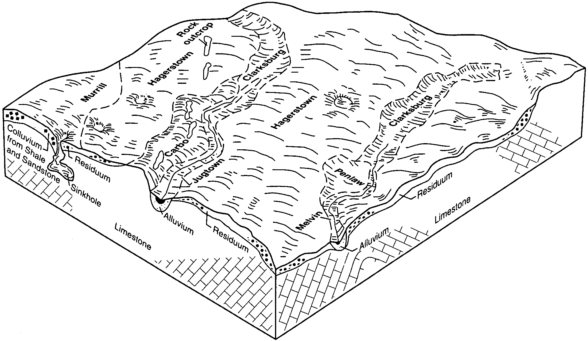
| Hagerstown-Carbo silty clay loams, 3 to 8 percent slopes | HbB | 16955 | 545137 | l982 | pa055 | 1999 | 1:24000 |
Hagerstown-Carbo silty clay loams, 3 to 8 percent slopes, very rocky | HcB | 10936 | 545135 | l980 | pa055 | 1999 | 1:24000 |
Hagerstown-Carbo silty clay loams, 8 to 15 percent slopes | HbC | 6488 | 545138 | l983 | pa055 | 1999 | 1:24000 |
Hagerstown-Carbo silty clay loams, 8 to 15 percent slopes, very rocky | HcC | 5793 | 545136 | l981 | pa055 | 1999 | 1:24000 |
Carbo silty clay loam, 3 to 8 percent slopes | CoB | 3186 | 545092 | l96m | pa055 | 1999 | 1:24000 |
Edom-Carbo silty clay loams, 3 to 8 percent slopes | EeB | 2791 | 545115 | l97c | pa055 | 1999 | 1:24000 |
Edom-Carbo silty clay loams, 8 to 15 percent slopes | EeC | 2012 | 545116 | l97d | pa055 | 1999 | 1:24000 |
Hagerstown-Carbo silty clay loams, 15 to 25 percent slopes | HbD | 918 | 545139 | l984 | pa055 | 1999 | 1:24000 |
Edom-Carbo silty clay loams, 15 to 25 percent slopes | EeD | 207 | 545117 | l97f | pa055 | 1999 | 1:24000 |
Carbo silty clay loam, 15 to 25 percent slopes | CoD | 558 | 544845 | l8yn | pa057 | 1999 | 1:24000 |
Hagerstown-Carbo silty clay loams, 3 to 8 percent slopes | HbB | 222 | 544876 | l8zn | pa057 | 1999 | 1:24000 |
Carbo silty clay loam, 8 to 15 percent slopes | CoC | 214 | 544844 | l8ym | pa057 | 1999 | 1:24000 |
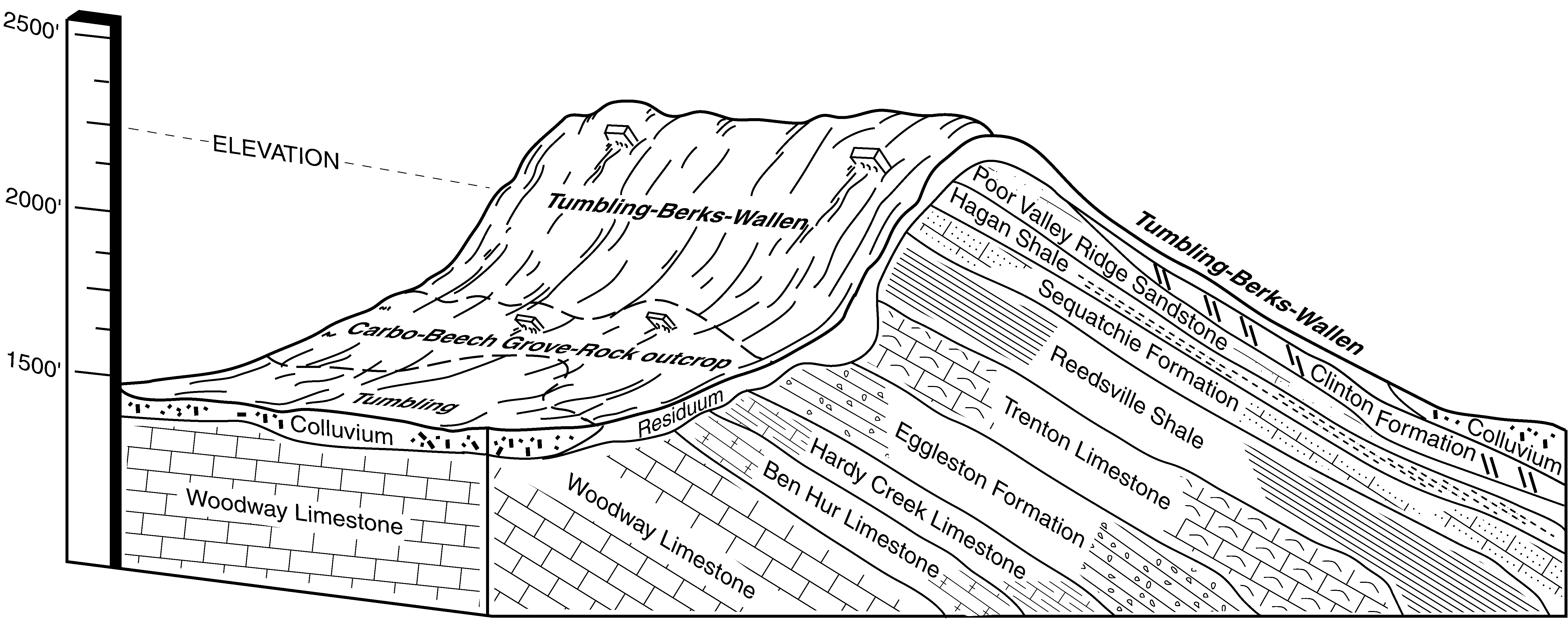
Talbott-Carbo-Rock outcrop complex, 30 to 60 percent slopes | TcF | 11705 | 525270 | kml6 | tn061 | 1990 | 1:24000 |
Talbott-Carbo-Rock outcrop complex, 15 to 30 percent slopes | TcE | 3245 | 525269 | kml5 | tn061 | 1990 | 1:24000 |
Carbo-Rock outcrop complex, 12 to 30 percent slopes | uCbrE | 5095 | 2517199 | 2q97m | tn133 | 2003 | 1:24000 |
Carbo-Rock outcrop complex, 20 to 60 percent slopes | CbF | 941 | 529603 | ks2z | tn153 | 1995 | 1:24000 |
Carbo-Rock outcrop complex, 12 to 30 percent slopes | uCbrE | 5431 | 2517197 | 2q97m | tn604 | 1974 | 1:20000 |
Colbert silty clay loam, eroded sloping phase (Carbo) | Cg | 155 | 1899457 | 21rjt | tn609 | 1955 | 1:20000 |
Carbo-Rock outcrop complex, 12 to 30 percent slopes | uCbrE | 4635 | 2517196 | 2q97m | tn610 | 1960 | 1:15840 |
Carbo-Rock outcrop complex, 12 to 30 percent slopes | uCbrE | 1146 | 2517198 | 2q97m | tn701 | 1985 | 1:24000 |
Carbo-Rock outcrop complex, 35 to 55 percent slopes, eroded | 11E | 2222 | 1402680 | 2xmq4 | va021 | 2005 | 1:24000 |
Carbo-Rock outcrop complex, 8 to 35 percent slopes, eroded | 11D | 1923 | 1402679 | 2xmq8 | va021 | 2005 | 1:24000 |
Carbo-Rock outcrop complex, karst, 8 to 35 percent slopes, eroded | 12D | 483 | 1402705 | 2wpkv | va021 | 2005 | 1:24000 |
Carbo-Opequon-Rock outcrop complex, 3 to 8 percent slopes | 5B | 3016 | 516580 | kbjw | va043 | 1980 | 1:15840 |
Oaklet-Carbo complex, rocky, 3 to 8 percent slopes | 32B | 2936 | 516541 | kbhm | va043 | 1980 | 1:15840 |
Carbo-Opequon-Rock outcrop complex, 8 to 15 percent slopes | 5C | 1974 | 516581 | kbjx | va043 | 1980 | 1:15840 |
Carbo-Rock outcrop complex, 35 to 55 percent slopes, eroded | 11F | 1265 | 2481047 | 2xmq4 | va045 | 2010 | 1:24000 |
Carbo-Rock outcrop complex, 8 to 35 percent slopes, eroded | 11E | 1221 | 2481046 | 2xmq8 | va045 | 2010 | 1:24000 |
Carbo-Rock outcrop complex, karst, 8 to 35 percent slopes, eroded | 12E | 421 | 2481076 | 2wpkv | va045 | 2010 | 1:24000 |
Carbo-Oaklet, very rocky silt loams, 2 to 15 percent slopes | 6C | 3830 | 521135 | kh8t | va069 | 1983 | 1:15840 |
Carbo silt loam, 2 to 7 percent slopes | 5B | 1668 | 521133 | kh8r | va069 | 1983 | 1:15840 |
Carbo-Oaklet-Rock outcrop complex, 2 to 15 percent slopes | 7C | 1624 | 521136 | kh8v | va069 | 1983 | 1:15840 |
Carbo silt loam, 7 to 15 percent slopes | 5C | 565 | 521134 | kh8s | va069 | 1983 | 1:15840 |
Carbo-Rock outcrop complex, 25 to 65 percent slopes | 6F | 6359 | 516710 | 2xmq2 | va071 | 1981 | 1:15840 |
Carbo silty clay loam, very rocky, 15 to 45 percent slopes | 5D | 3950 | 516709 | kbp1 | va071 | 1981 | 1:15840 |
Carbo silty clay loam, very rocky, 2 to 15 percent slopes | 5C | 559 | 516708 | kbp0 | va071 | 1981 | 1:15840 |
Carbo-Beech Grove complex, 25 to 60 percent slopes, rocky | 8E | 14250 | 521740 | khxb | va105 | 1997 | 1:24000 |
Carbo-Beech Grove complex, 15 to 25 percent slopes, rocky | 8D | 6835 | 521739 | khx9 | va105 | 1997 | 1:24000 |
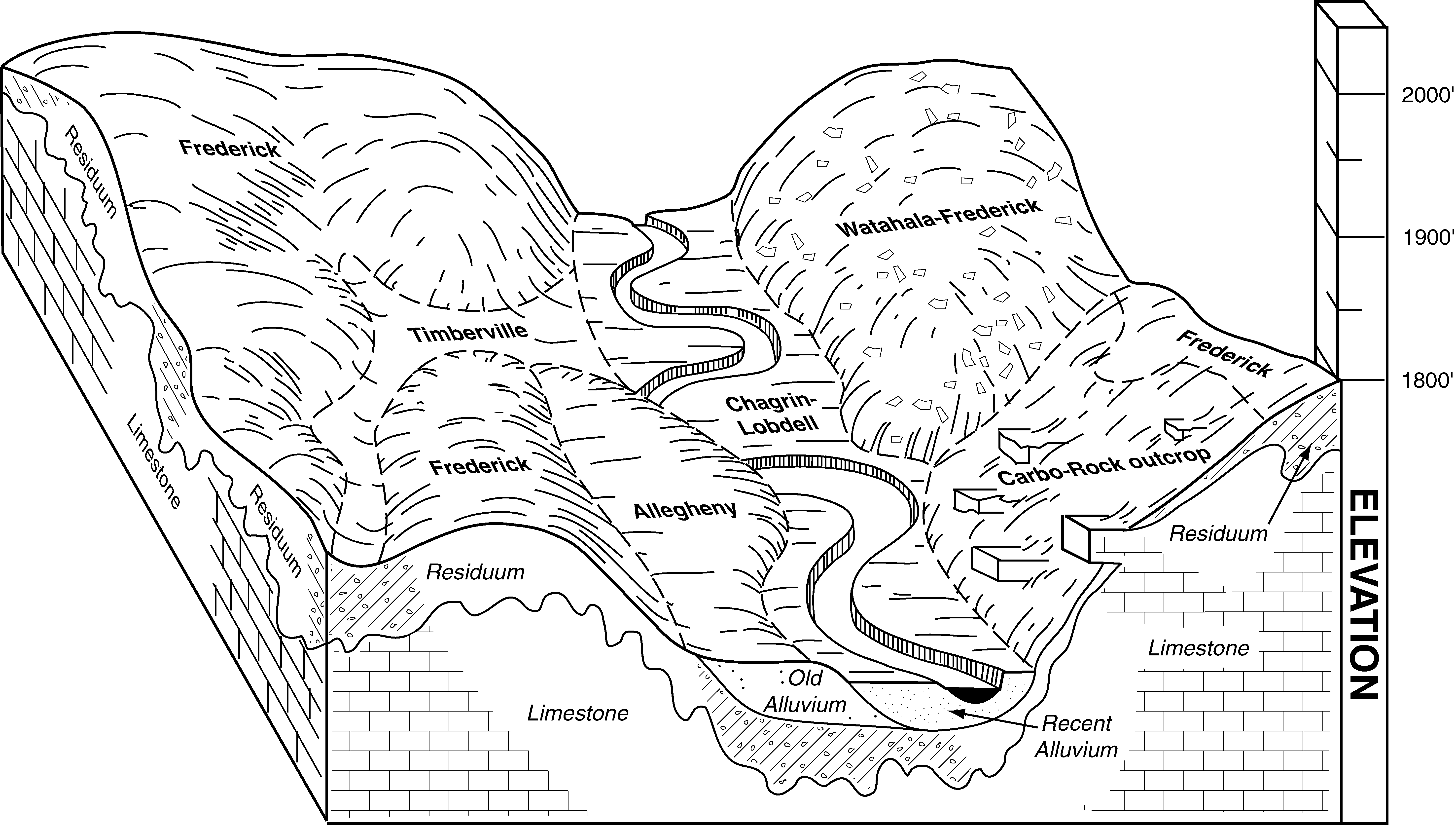
Frederick-Carbo complex, 25 to 35 percent slopes, rocky | 15E | 5841 | 521727 | khwx | va105 | 1997 | 1:24000 |
Carbo-Rock outcrop complex, 15 to 25 percent slopes | 9D | 3148 | 521717 | khwl | va105 | 1997 | 1:24000 |
Carbo-Beech Grove complex, 7 to 15 percent slopes, rocky | 8C | 2664 | 521738 | khx8 | va105 | 1997 | 1:24000 |
Frederick-Carbo complex, 15 to 25 percent slopes, rocky | 15D | 2388 | 521726 | khww | va105 | 1997 | 1:24000 |
Carbo-Rock outcrop complex, 7 to 15 percent slopes | 9C | 1960 | 521716 | khwk | va105 | 1997 | 1:24000 |
Carbo-Rock outcrop complex, 25 to 35 percent slopes | 9E | 1759 | 521718 | khwm | va105 | 1997 | 1:24000 |
Frederick-Carbo complex, 7 to 15 percent slopes, rocky | 15C | 1659 | 521725 | khwv | va105 | 1997 | 1:24000 |
Carbo silt loam, 7 to 15 percent slopes | 7C | 1334 | 521710 | khwc | va105 | 1997 | 1:24000 |
Carbo silt loam, 15 to 25 percent slopes | 7D | 991 | 521711 | khwd | va105 | 1997 | 1:24000 |
Frederick-Carbo complex, 35 to 60 percent slopes, rocky | 15F | 821 | 521728 | khwy | va105 | 1997 | 1:24000 |
Carbo and Chilhowie soils, 7 to 15 percent slopes | 9C | 946 | 517123 | kc3d | va121 | 1980 | 1:15840 |
Carbo and Chilhowie soils, 15 to 25 percent slopes | 9D | 891 | 517124 | kc3f | va121 | 1980 | 1:15840 |
Carbo-Rock outcrop complex, 15 to 35 percent slopes | 6E | 2281 | 517355 | kcbw | va139 | 1995 | 1:20000 |
Oaklet-Carbo complex, 15 to 35 percent slopes, very rocky | 37E | 1426 | 517261 | kc7v | va139 | 1995 | 1:20000 |
Carbo-Rock outcrop complex, 2 to 15 percent slopes | 6C | 1198 | 517354 | kcbv | va139 | 1995 | 1:20000 |
Oaklet-Carbo complex, 2 to 15 percent slopes, very rocky | 37C | 966 | 517260 | kc7t | va139 | 1995 | 1:20000 |
Carbo-Rock outcrop complex, 10 to 45 percent slopes | 6E | 5707 | 521297 | khg1 | va155 | 1981 | 1:15840 |
Carbo silty clay loam, very rocky, 15 to 30 percent slopes | 5D | 4170 | 521296 | khg0 | va155 | 1981 | 1:15840 |
Carbo silty clay loam, very rocky, 7 to 15 percent slopes | 5C | 2400 | 521295 | khfz | va155 | 1981 | 1:15840 |
Rock outcrop-Newbern-Carbo complex, 30 to 65 percent slopes | 29F | 2219 | 521278 | khff | va155 | 1981 | 1:15840 |
Carbo silty clay loam, 7 to 15 percent slopes | 4C | 854 | 521293 | khfx | va155 | 1981 | 1:15840 |
Carbo silty clay loam, 15 to 35 percent slopes | 4D | 696 | 521294 | khfy | va155 | 1981 | 1:15840 |
Carbo-Opequon complex, 15 to 35 percent slopes, very rocky | 9E | 8545 | 2514736 | 2q9ld | va163 | 2010 | 1:24000 |
Carbo-Opequon-Rock outcrop complex, 35 to 70 percent slopes | 10F | 4480 | 2514737 | 2q9lf | va163 | 2010 | 1:24000 |
Carbo-Opequon complex, 3 to 15 percent slopes, very rocky | 9C | 2133 | 2514735 | 2q9lc | va163 | 2010 | 1:24000 |
Rock outcrop-Carbo complex, 0 to 20 percent slopes | 55C | 5632 | 518437 | kdgs | va165 | 1980 | 1:20000 |
Carbo-Endcav-Rock outcrop complex, 7 to 15 percent slopes | 12C | 3623 | 518353 | kdd2 | va165 | 1980 | 1:20000 |
Carbo-Endcav-Rock outcrop complex, 2 to 7 percent slopes | 12B | 2346 | 518352 | kdd1 | va165 | 1980 | 1:20000 |
Carbo-Rock outcrop complex, 25 to 65 percent slopes, eroded | 14E | 16850 | 1671145 | 2xmq3 | va167 | 2006 | 1:24000 |
Carbo-Rock outcrop complex, karst, 8 to 35 percent slopes, eroded | 15D | 9101 | 1671866 | 2wpkv | va167 | 2006 | 1:24000 |
Carbo-Rock outcrop complex, 8 to 25 percent slopes, eroded | 14D | 7932 | 1671838 | 2xmq7 | va167 | 2006 | 1:24000 |
Carbo-Beech Grove complex, 15 to 25 percent slopes, very rocky, eroded | 12D | 6275 | 1671132 | 1t2yh | va167 | 2006 | 1:24000 |
Carbo-Beech Grove complex, 8 to 15 percent slopes, very rocky, eroded | 12C | 3625 | 1671131 | 1t2yg | va167 | 2006 | 1:24000 |
Carbo-Beech Grove complex, 25 to 35 percent slopes, very rocky, eroded | 12E | 3092 | 1671831 | 1t3p1 | va167 | 2006 | 1:24000 |
Carbo-Beech Grove complex, 35 to 65 percent slopes, very rocky, eroded | 12F | 2912 | 1671832 | 1t3p2 | va167 | 2006 | 1:24000 |
Carbo-Frederick-Urban land complex, 0 to 15 percent slopes, eroded | 13C | 232 | 1671874 | 1t3qf | va167 | 2006 | 1:24000 |
Carbo-Rock outcrop complex, 25 to 65 percent slopes, eroded | 11F | 28800 | 778035 | 2xmq3 | va169 | 2003 | 1:24000 |
Carbo-Beech Grove complex, 35 to 60 percent slopes, very rocky, eroded | 8F | 12740 | 778029 | v3lq | va169 | 2003 | 1:24000 |
Carbo-Rock outcrop complex, karst, 8 to 35 percent slopes, eroded | 12D | 6696 | 778036 | 2wpkv | va169 | 2003 | 1:24000 |
Carbo-Beech Grove complex, 25 to 35 percent slopes, very rocky, eroded | 8E | 4161 | 778028 | v3lp | va169 | 2003 | 1:24000 |
Carbo-Frederick complex, karst, 15 to 25 percent slopes, very rocky, eroded | 10D | 3475 | 778032 | v3lt | va169 | 2003 | 1:24000 |
Groseclose-Carbo silty clay loams, 15 to 25 percent slopes, severely eroded | 23D | 3026 | 778062 | v3ms | va169 | 2003 | 1:24000 |
Frederick-Carbo complex, karst, 8 to 15 percent slopes, very rocky, eroded | 19C | 2760 | 778051 | v3mf | va169 | 2003 | 1:24000 |
Carbo-Rock outcrop complex, 8 to 25 percent slopes, eroded | 11D | 2726 | 778034 | 2xmq7 | va169 | 2003 | 1:24000 |
Carbo-Beech Grove complex, 15 to 25 percent slopes, very rocky, eroded | 8D | 2394 | 778027 | v3ln | va169 | 2003 | 1:24000 |
Carbo-Frederick complex, 25 to 35 percent slopes, very rocky, eroded | 9E | 1457 | 778031 | v3ls | va169 | 2003 | 1:24000 |
Groseclose-Carbo silty clay loams, karst, 8 to 15 percent slopes, severely eroded | 24C | 791 | 778063 | v3mt | va169 | 2003 | 1:24000 |
Carbo-Beech Grove complex, 8 to 15 percent slopes, very rocky, eroded | 8C | 343 | 778026 | v3lm | va169 | 2003 | 1:24000 |
Carbo-Endcav complex, 2 to 15 percent slopes, very rocky | 9C | 4739 | 520828 | kgyx | va171 | 1988 | 1:15840 |
Rock outcrop-Carbo complex, 2 to 25 percent slopes | 51D | 2946 | 520781 | kgxd | va171 | 1988 | 1:15840 |
Carbo silty clay loam, 2 to 7 percent slopes | 8B | 1049 | 520826 | kgyv | va171 | 1988 | 1:15840 |
Carbo-Endcav complex, 15 to 35 percent slopes, very rocky | 9D | 814 | 520829 | kgyy | va171 | 1988 | 1:15840 |
Carbo silty clay loam, 7 to 15 percent slopes | 8C | 779 | 520827 | kgyw | va171 | 1988 | 1:15840 |
Carbo-Rock outcrop complex, 25 to 65 percent slopes | 8E | 17995 | 518789 | 2xmq2 | va173 | 1995 | 1:24000 |
Carbo-Rock outcrop complex, 7 to 25 percent slopes | 8D | 4110 | 518788 | 2xmq5 | va173 | 1995 | 1:24000 |
Carbo-Rock outcrop complex, karst, 7 to 65 percent slopes | 9E | 3170 | 518793 | 2xmq6 | va173 | 1995 | 1:24000 |
Carbo silty clay loam, 7 to 15 percent slopes | 7C | 1062 | 518786 | kdv1 | va173 | 1995 | 1:24000 |
Carbo silty clay loam, 15 to 25 percent slopes | 7D | 825 | 518787 | kdv2 | va173 | 1995 | 1:24000 |
Carbo-Rock outcrop complex, 25 to 65 percent slopes | 12E | 18454 | 522115 | 2xmq2 | va185 | 1996 | 1:24000 |
Carbo-Rock outcrop complex, karst, 7 to 65 percent slopes | 13E | 7852 | 522135 | 2xmq6 | va185 | 1996 | 1:24000 |
Carbo-Rock outcrop complex, 7 to 25 percent slopes | 12D | 3883 | 522114 | 2xmq5 | va185 | 1996 | 1:24000 |
Carbo silt loam, 35 to 65 percent slopes | 11F | 650 | 522009 | kj60 | va185 | 1996 | 1:24000 |
Carbo silt loam, 7 to 15 percent slopes | 11C | 236 | 522006 | kj5x | va185 | 1996 | 1:24000 |
Carbo silt loam, 15 to 25 percent slopes | 11D | 188 | 522007 | kj5y | va185 | 1996 | 1:24000 |
Carbo silt loam, 25 to 35 percent slopes | 11E | 132 | 522008 | kj5z | va185 | 1996 | 1:24000 |
Carbo-Endcav silty clay loams, 7 to 15 percent slopes, very rocky | 6C | 1000 | 518866 | kdxm | va187 | 1980 | 1:15840 |
Carbo-Endcav-Rock outcrop complex, 7 to 15 percent slopes | 7C | 918 | 518867 | kdxn | va187 | 1980 | 1:15840 |
Carbo-Rock outcrop complex, 8 to 35 percent slopes | 13E | 471 | 2507482 | 2q7pc | va195 | 2010 | 1:24000 |
Carbo-Beech Grove complex, 25 to 60 percent slopes, rocky | 12G | 416 | 2507481 | 2q7pb | va195 | 2010 | 1:24000 |
Carbo-Rock outcrop complex, 35 to 55 percent slopes | 13F | 249 | 2507483 | 2q7pd | va195 | 2010 | 1:24000 |
Carbo-Beech Grove complex, 15 to 25 percent slopes, rocky | 12D | 53 | 2507480 | 2q7p9 | va195 | 2010 | 1:24000 |
Carbo-Rock outcrop complex, karst, 8 to 35 percent slopes | 14E | 17 | 2507484 | 2q7pf | va195 | 2010 | 1:24000 |
Carbo-Rock outcrop complex, 35 to 60 percent slopes | 49E | 107 | 2525425 | 2rm34 | va606 | | 1:24000 |
Carbo-Oaklet silt loams, 2 to 15 percent slopes, very rocky | 6C | 13 | 3025640 | 2xr7w | va840 | 2017 | 1:12000 |
Carbo silt loam, 2 to 7 percent slopes | 5B | 5 | 3025639 | 2xr7v | va840 | 2017 | 1:12000 |
Carbo-Oaklet-Rock outcrop complex, 2 to 15 percent slopes | 7C | 4 | 3025641 | 2xr7x | va840 | 2017 | 1:12000 |
Carbo-Opequon complex, 3 to 8 percent slopes | CgB | 2040 | 516218 | kb56 | wv003 | 1997 | 1:24000 |
Carbo-Opequon complex, 3 to 15 percent slopes, very rocky | ChC | 817 | 516220 | kb58 | wv003 | 1997 | 1:24000 |
Carbo-Opequon complex, 8 to 15 percent slopes | CgC | 751 | 516219 | kb57 | wv003 | 1997 | 1:24000 |
Carbo-Endcav silty clay loams, 3 to 8 percent slopes | CeB | 744 | 516216 | kb54 | wv003 | 1997 | 1:24000 |
Carbo-Opequon complex, 15 to 35 percent slopes, very rocky | ChE | 355 | 516221 | kb59 | wv003 | 1997 | 1:24000 |
Carbo-Endcav silty clay loams, 8 to 15 percent slopes | CeC | 320 | 516217 | kb55 | wv003 | 1997 | 1:24000 |
Urban land-Carbo-Endcav complex, 0 to 15 percent slopes | UvC | 290 | 516289 | kb7h | wv003 | 1997 | 1:24000 |
Carbo-Rock outcrop complex, 15 to 25 percent slopes | CbD | 1004 | 1710282 | 1vdpd | wv037 | | 1:24000 |
Carbo-Rock outcrop complex, 3 to 15 percent slopes | CbC | 515 | 1710281 | 1vdpc | wv037 | | 1:24000 |
Carbo silty clay loam, 8 to 15 percent slopes, very rocky | CaC | 399 | 1710259 | 1vdnn | wv037 | | 1:24000 |
Carbo silty clay loam, 3 to 8 percent slopes, very rocky | CaB | 54 | 1710258 | 1vdnm | wv037 | | 1:24000 |