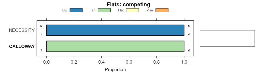
| Calloway silt loam, 1 to 3 percent slopes | 6 | 55970 | 565089 | lz0p | ar003 | 1977 | 1:20000 |
Calloway silt loam, 0 to 1 percent slopes | 5 | 46072 | 565088 | 2tzs8 | ar003 | 1977 | 1:20000 |
Calloway silt loam, 0 to 1 percent slopes | CaA | 10730 | 565252 | lz5y | ar017 | 1964 | 1:20000 |
Calloway silt loam, 1 to 3 percent slopes | CaB | 4784 | 565253 | lz5z | ar017 | 1964 | 1:20000 |
Calloway-Henry silt loams, 0 to 2 percent slopes | CHA | 1724 | 565251 | lz5x | ar017 | 1964 | 1:20000 |
Calloway-Grenada silt loams, 0 to 3 percent slopes | CGB | 336 | 565250 | lz5w | ar017 | 1964 | 1:20000 |
Calloway silt loam, 0 to 1 percent slopes | 9 | 9920 | 564154 | 2t238 | ar031 | 1976 | 1:20000 |
Calloway silt loam, 1 to 3 percent slopes | 10 | 5170 | 564116 | 2t23c | ar031 | 1976 | 1:20000 |
Calloway silt loam, 0 to 1 percent slopes | ClA | 29250 | 564377 | 2t238 | ar037 | 1966 | 1:20000 |
Calloway silt loam, 1 to 3 percent slopes | ClB | 10190 | 564378 | 2t23c | ar037 | 1966 | 1:20000 |
Calloway silt loam, 1 to 3 percent slopes, eroded | ClB2 | 1180 | 564379 | ly8s | ar037 | 1966 | 1:20000 |
Henry-Calloway association | HC | 31836 | 565459 | lzdm | ar043 | 1972 | 1:24000 |
Calloway silt loam, 0 to 1 percent slopes | CoA | 31612 | 565451 | 2tzs8 | ar043 | 1972 | 1:24000 |
Calloway silt loam, 1 to 3 percent slopes | CoB | 7208 | 565452 | lzdd | ar043 | 1972 | 1:24000 |
Calloway silt loam, 0 to 1 percent slopes | 7A | 22745 | 577969 | 2t238 | ar055 | 1995 | 1:24000 |
Calloway silt loam, 1 to 3 percent slopes | 7B | 4701 | 577968 | 2t23c | ar055 | 1995 | 1:24000 |
Calloway silt loam, 0 to 1 percent slopes | CbA | 32900 | 564077 | 2t238 | ar077 | 1974 | 1:20000 |
Calloway silt loam, 1 to 3 percent slopes | CbB | 8380 | 564078 | 2t23c | ar077 | 1974 | 1:20000 |
Calloway silt loam, 0 to 1 percent slopes | Cb | 3435 | 565962 | 2t238 | ar095 | 1974 | 1:20000 |
Calloway silt loam, 0 to 1 percent slopes | CbA | 17850 | 564222 | 2t238 | ar107 | 1971 | 1:20000 |
Calloway silt loam, 1 to 3 percent slopes | CbB | 7830 | 564223 | 2t23c | ar107 | 1971 | 1:20000 |
Calloway silt loam, 0 to 1 percent slopes | CaA | 14559 | 564265 | 2t238 | ar111 | 1973 | 1:20000 |
Calloway silt loam, 1 to 3 percent slopes | CaB | 5718 | 564266 | 2t23c | ar111 | 1973 | 1:20000 |
Calloway silt loam, 0 to 1 percent slopes | ClA | 34670 | 564436 | 2t238 | ar123 | 1964 | 1:20000 |
Calloway silt loam, 1 to 3 percent slopes | ClB | 9630 | 564437 | 2t23c | ar123 | 1964 | 1:20000 |
Calloway silt loam, 0 to 1 percent slopes | 5 | 38224 | 566666 | 2tzs8 | ar145 | 1980 | 1:20000 |
Calloway silt loam, 0 to 1 percent slopes | ClA | 5731 | 749401 | 2t238 | ar147 | 1995 | 1:24000 |
Calloway silt loam, 1 to 3 percent slopes | ClB | 3065 | 749408 | 2t23c | ar147 | 1995 | 1:24000 |
Calloway silt loam, 0 to 1 percent slopes | 4 | 10243 | 564862 | 2tzs8 | ar660 | 1975 | 1:20000 |
Calloway silt loam, 1 to 3 percent slopes | 5 | 8031 | 564873 | lysq | ar660 | 1975 | 1:20000 |
Calloway-Urban land complex | 6 | 5088 | 564876 | lyst | ar660 | 1975 | 1:20000 |
Calloway silt loam, 0 to 1 percent slopes | 3 | 72529 | 564313 | 2tzs8 | ar680 | 1980 | 1:20000 |
Calloway silt loam, 2 to 4 percent slopes, eroded | CaB2 | 3235 | 654177 | pyqh | ky075 | 2002 | 1:12000 |
Calloway silt loam, 0 to 2 percent slopes | CaA | 2403 | 654176 | pyqg | ky075 | 2002 | 1:12000 |
Calloway silt loam, 0 to 3 percent slopes | CaA | 2663 | 570621 | m4s4 | ky083 | 1995 | 1:12000 |
Calloway silt loam, 0 to 2 percent slopes | CaA | 16934 | 1597352 | 1qm5h | ky602 | 1972 | 1:12000 |
Calloway silt loam, 2 to 4 percent slopes, eroded | CaB2 | 9352 | 1597353 | 1qm5j | ky602 | 1972 | 1:12000 |
Calloway-Kurk complex, 0 to 2 percent slopes | CwA | 14898 | 2232401 | 2dxzy | ky610 | 1968 | 1:12000 |
Calloway silt loam, 2 to 6 percent slopes | CaB | 10891 | 2623440 | 2qykf | ky610 | 1968 | 1:12000 |
Calloway silt loam, 2 to 6 percent slopes, eroded | CaB2 | 3707 | 2232403 | 2dy00 | ky610 | 1968 | 1:12000 |
Calloway silt loam, 0 to 3 percent slopes | CaA | 4673 | 570518 | m4nt | ky611 | 1991 | 1:20000 |
Calloway silt loam, 0 to 2 percent slopes, rarely flooded | CbA | 620 | 570519 | m4nv | ky611 | 1991 | 1:20000 |
Calloway silt loam | Cw | 8480 | 1722383 | 1vt8r | la025 | 1983 | 1:24000 |
Calloway silt loam, rarely flooded | Cy | 2151 | 1722384 | 1vt8s | la025 | 1983 | 1:24000 |
Calloway silt loam | Cw | 31927 | 1711091 | 1vfjh | la041 | 1979 | 1:24000 |
Calhoun-Calloway complex | Cu | 13048 | 1711090 | 1vfjg | la041 | 1979 | 1:24000 |
Calhoun-Calloway silt loams, gently undulating | Cc | 4119 | 1714765 | 1vkc0 | la083 | 1988 | 1:24000 |
Calloway silt loam, 1 to 3 percent slopes | Co | 275 | 1714766 | 1vkc1 | la083 | 1988 | 1:24000 |
Calhoun-Calloway complex | 2 | 12446 | 570376 | m4j7 | la123 | 1975 | 1:24000 |
Calloway silt loam | 3 | 417 | 570378 | m4j9 | la123 | 1975 | 1:24000 |
Calloway silt loam, 0 to 2 percent slopes | 41A | 1319 | 331774 | c47d | ms007 | 1997 | 1:24000 |
Calloway and Deerford soils, 0 to 2 percent slopes | 43A | 574 | 331776 | c47g | ms007 | 1997 | 1:24000 |
Calloway silt loam, 0 to 2 percent slopes | CwA | 1818 | 331803 | c48b | ms009 | 1972 | 1:20000 |
Calloway silt loam, 0 to 1 percent slopes | 1A | 1599 | 567528 | m1kc | ms015 | 1985 | 1:20000 |
Calloway silt loam, 0 to 2 percent slopes | CaA | 4182 | 567574 | m1lv | ms021 | 1961 | 1:20000 |
Calloway silt loam, 2 to 5 percent slopes | CaB | 1569 | 567575 | m1lw | ms021 | 1961 | 1:20000 |
Calloway silt loam, 0 to 2 percent slopes | CoA | 3267 | 567678 | m1q6 | ms029 | 1981 | 1:20000 |
Calloway silt loam, 2 to 5 percent slopes, moderately eroded | Cd | 787 | 567722 | 2t23h | ms033 | 1955 | 1:24000 |
Calloway silt loam, severely eroded gently sloping phase | Ce | 96 | 567723 | m1rn | ms033 | 1955 | 1:24000 |
Calloway silt loam, very gently sloping phase | Cc | 93 | 567721 | m1rl | ms033 | 1955 | 1:24000 |
Calloway silt loam, 0 to 2 percent slopes | CaA | 7158 | 567836 | m1w9 | ms043 | 1965 | 1:15840 |
Calloway silt loam, 2 to 5 percent slopes | CaB | 1500 | 567837 | m1wb | ms043 | 1965 | 1:15840 |
Calloway silt loam | Co | 7386 | 567905 | m1yj | ms049 | 1976 | 1:20000 |
Calloway-Urban land complex | CuA | 2167 | 567906 | m1yk | ms049 | 1976 | 1:20000 |
Calloway silt loam, 0 to 2 percent slopes | CaA | 2985 | 567951 | m200 | ms051 | 1997 | 1:20000 |
Grenada-Calloway association, frequently flooded | 20 | 1944 | 332816 | c5b0 | ms071 | 1979 | 1:20000 |
Calloway silt loam, 0 to 1 percent slopes | 6A | 1237 | 332836 | c5bn | ms071 | 1979 | 1:20000 |
Calloway silt loam, 0 to 1 percent slopes | CbA | 6480 | 568218 | m28m | ms089 | 1981 | 1:20000 |
Calloway silt loam, 1 to 3 percent slopes | CbB | 4343 | 568219 | m28n | ms089 | 1981 | 1:20000 |
Calloway silt loam, 2 to 5 percent slopes, moderately eroded | CcB2 | 3099 | 568268 | 2t23h | ms093 | 1968 | 1:20000 |
Calloway silt loam, 0 to 2 percent slopes | CcA | 492 | 568267 | m2b6 | ms093 | 1968 | 1:20000 |
Calloway silt loam | Ca | 2636 | 333238 | c5rm | ms097 | 1971 | 1:20000 |
Calloway silt loam, 2 to 5 percent slopes | CaB | 2774 | 568308 | m2cj | ms107 | 1961 | 1:24000 |
Calloway silt loam, 0 to 2 percent slopes | CaA | 2683 | 568307 | m2ch | ms107 | 1961 | 1:24000 |
Calloway silt loam, 0 to 3 percent slopes | ClA | 355 | 568508 | m2kz | ms135 | 1966 | 1:24000 |
Calloway silt loam, 2 to 5 percent slopes, moderately eroded | CaB2 | 1625 | 568563 | 2t23h | ms137 | 1964 | 1:15840 |
Calloway silt loam, 2 to 5 percent slopes | CaB | 1531 | 568562 | m2mq | ms137 | 1964 | 1:15840 |
Calloway silt loam, 0 to 2 percent slopes | CaA | 1402 | 568561 | m2mp | ms137 | 1964 | 1:15840 |
Calloway silt loam | Ca | 966 | 568677 | m2rf | ms149 | 1962 | 1:15840 |
Calloway silt loam, 0 to 2 percent slopes | 5A | 8515 | 571064 | m57f | ms157 | 2006 | 1:24000 |
Calloway silt loam, 0 to 2 percent slopes | CaA | 2318 | 334641 | c76w | ms161 | 1975 | 1:20000 |
Calloway silt loam, 0 to 2 percent slopes | ClA | 5705 | 568780 | m2vr | ms163 | 1969 | 1:20000 |
Calloway silt loam, 2 to 5 percent slopes | ClB | 5029 | 568781 | m2vs | ms163 | 1969 | 1:20000 |
Calloway silt loam | Ca | 4816 | 327168 | bzft | tn017 | 1980 | 1:15840 |
Calloway silt loam, 0 to 2 percent slopes, north | Cb | 1152 | 566741 | 2t239 | tn033 | 1985 | 1:24000 |
Calloway silt loam, 0 to 2 percent slopes, north | Ca | 10676 | 566772 | 2t239 | tn045 | 1963 | 1:15840 |
Calloway silt loam, 2 to 5 percent slopes, moderately eroded | CaB2 | 7980 | 566960 | 2t23h | tn047 | 1961 | 1:15840 |
Calloway silt loam, 2 to 5 percent slopes | CaB | 4205 | 566959 | m0z0 | tn047 | 1961 | 1:15840 |
Calloway silt loam, 0 to 2 percent slopes, north | CaA | 2221 | 566958 | 2t239 | tn047 | 1961 | 1:15840 |
Calloway silt loam, terrace, 2 to 5 percent slopes | CbB | 1357 | 566962 | m0z3 | tn047 | 1961 | 1:15840 |
Calloway silt loam, terrace, 2 to 5 percent slopes, eroded | CbB2 | 1320 | 566963 | m0z4 | tn047 | 1961 | 1:15840 |
Calloway silt loam, terrace, 0 to 2 percent slopes | CbA | 1186 | 566961 | 31fdc | tn047 | 1961 | 1:15840 |
Calloway silt loam, 1 to 3 percent slopes, eroded | CaB2 | 8363 | 567039 | m11l | tn053 | 1990 | 1:24000 |
Calloway silt loam | Ca | 8090 | 567068 | m12j | tn075 | 1990 | 1:24000 |
Calloway silt loam, 2 to 5 percent slopes, moderately eroded | Cb | 692 | 327693 | 2t23h | tn077 | 1955 | 1:20000 |
Calloway silt loam, gently sloping phase | Ca | 272 | 327692 | bzzq | tn077 | 1955 | 1:20000 |
Calloway silt loam, 2 to 5 percent slopes, moderately eroded | CaB2 | 2194 | 2545239 | 2t23h | tn079 | 2012 | 1:12000 |
Calloway-Kurk complex, 0 to 2 percent slopes | CkA | 1559 | 2545240 | 2qs7g | tn079 | 2012 | 1:12000 |
Calloway silt loam, 0 to 2 percent slopes, north | Ca | 2325 | 567149 | 2t239 | tn097 | 1985 | 1:24000 |
Calloway silt loam, 0 to 2 percent slopes, north | Co | 9364 | 567192 | 2t239 | tn113 | 1974 | 1:20000 |
Calloway silt loam | Ca | 14008 | 567236 | m17y | tn131 | 1966 | 1:15840 |
Calloway silt loam, 0 to 2 percent slopes, north | Ca | 15068 | 567283 | 2t239 | tn157 | 1966 | 1:15840 |
Calloway silt loam | Ca | 10664 | 567365 | m1d3 | tn183 | 1986 | 1:24000 |

