| Clymer loam, 3 to 8 percent slopes | CmB | 204 | 2401101 | 2lljw | md001 | 2009 | 1:12000 |
Clymer loam, 8 to 15 percent slopes | CmC | 126 | 2401102 | 2lljx | md001 | 2009 | 1:12000 |
Clymer loam, 0 to 3 percent slopes | CmA | 85 | 2401100 | 2lljv | md001 | 2009 | 1:12000 |
Clymer channery loam, 0 to 10 percent slopes | CrB | 1740 | 532904 | kwjg | md023 | 1970 | 1:20000 |
Clymer loam, 8 to 15 percent slopes | CmC | 1000 | 537348 | l14t | oh009 | 1981 | 1:15840 |
Steinsburg-Clymer association, steep | ScE | 10366 | 536841 | l0mg | oh053 | 1988 | 1:15840 |
Clymer silt loam, 3 to 8 percent slopes | CkB | 307 | 536796 | l0l0 | oh053 | 1988 | 1:15840 |
Clymer loam, 15 to 25 percent slopes | ChD | 288 | 536795 | l0kz | oh053 | 1988 | 1:15840 |
Clymer silt loam, 8 to 15 percent slopes | CkC | 241 | 536797 | l0l1 | oh053 | 1988 | 1:15840 |
Clymer silt loam, 8 to 15 percent slopes | CkC | 12011 | 536014 | kzrs | oh079 | 1981 | 1:15840 |
Clymer loam, 15 to 25 percent slopes | ChD | 11551 | 536012 | kzrq | oh079 | 1981 | 1:15840 |
Rigley-Clymer association, steep | RmE | 10609 | 536042 | kzsp | oh079 | 1981 | 1:15840 |
Clymer silt loam, 3 to 8 percent slopes | CkB | 736 | 536013 | kzrr | oh079 | 1981 | 1:15840 |
Steinsburg-Clymer association, steep | SrE | 470 | 1460515 | 1l0sd | oh079 | 1981 | 1:15840 |
Steinsburg-Clymer association, steep | SfE | 2456 | 536183 | kzy7 | oh087 | 1989 | 1:15840 |
Clymer loam, 15 to 25 percent slopes | ChD | 14 | 1689033 | 1tpky | oh131 | 1984 | 1:15840 |
Rigley-Clymer association, steep | RkE | 4 | 1689040 | 1tpl5 | oh131 | 1984 | 1:15840 |
Clymer silt loam, 8 to 15 percent slopes | CkC | 4 | 1689035 | 2t32m | oh131 | 1984 | 1:15840 |
Clymer silt loam, 8 to 15 percent slopes | CkC | 21 | 1460817 | 1l134 | oh145 | 1984 | 1:15840 |
Steinsburg-Clymer association, steep | SvE | 72 | 1481845 | 1lqzg | oh163 | 1998 | 1:15840 |
Clymer silt loam, 8 to 15 percent slopes | CrC | 29 | 1481843 | 1lqzd | oh163 | 1998 | 1:15840 |
Clymer silt loam, 12 to 18 percent slopes | ClD | 733 | 536465 | l07b | oh167 | 1973 | 1:15840 |
Clymer silt loam, 6 to 12 percent slopes | ClC | 613 | 536464 | l079 | oh167 | 1973 | 1:15840 |
Clymer silt loam, 8 to 15 percent slopes | CmC | 1462 | 541665 | 2t32m | pa003 | 1973 | 1:15840 |
Clymer silt loam, 15 to 25 percent slopes | CmD | 1458 | 541666 | l5n3 | pa003 | 1973 | 1:15840 |
Clymer silt loam, 3 to 8 percent slopes | CmB | 950 | 541664 | l5n1 | pa003 | 1973 | 1:15840 |
Clymer loam, 8 to 15 percent slopes | CmC | 4088 | 2900250 | 2t32k | pa007 | 1978 | 1:15840 |
Clymer loam, 3 to 8 percent slopes | CmB | 2872 | 3180034 | 2t32j | pa007 | 1978 | 1:15840 |
Clymer loam, 15 to 25 percent slopes | CmD | 630 | 2900251 | 2t32l | pa007 | 1978 | 1:15840 |
Hazleton-Clymer association, 8 to 25 percent slopes, extremely stony | HTC | 19627 | 541799 | l5sd | pa009 | 1989 | 1:24000 |
Hazleton-Clymer association, 25 to 45 percent slopes, extremely stony | HTE | 13662 | 541800 | l5sf | pa009 | 1989 | 1:24000 |
Clymer very stony loam, 3 to 8 percent slopes | CyB | 3200 | 542339 | l6bt | pa013 | 1978 | 1:20000 |
Clymer very stony loam, 8 to 25 percent slopes | CyD | 1822 | 542340 | l6bv | pa013 | 1978 | 1:20000 |
Clymer loam, 3 to 8 percent slopes | CvB | 983 | 542338 | l6bs | pa013 | 1978 | 1:20000 |
Clymer loam, 3 to 8 percent slopes | CmB | 3078 | 538163 | 2t32j | pa019 | 1984 | 1:15840 |
Clymer silt loam, 8 to 15 percent slopes | CmC | 1 | 538228 | 2t32m | pa019 | 1984 | 1:15840 |
Clymer very stony sandy loam, 0 to 8 percent slopes | CvB | 26080 | 538266 | l23f | pa027 | 1975 | 1:20000 |
Clymer very stony sandy loam, 8 to 25 percent slopes | CvD | 9496 | 538267 | l23g | pa027 | 1975 | 1:20000 |
Clymer sandy loam, 3 to 8 percent slopes | ClB | 2761 | 538264 | l23c | pa027 | 1975 | 1:20000 |
Clymer sandy loam, 8 to 15 percent slopes | ClC | 646 | 538265 | l23d | pa027 | 1975 | 1:20000 |
Clymer channery loam, 3 to 8 percent slopes | ClB | 5460 | 563167 | lx0p | pa031 | 2012 | 1:24000 |
Clymer channery loam, 8 to 15 percent slopes | ClC | 2447 | 563168 | lx0q | pa031 | 2012 | 1:24000 |
Clymer loam, 0 to 8 percent slopes, very stony | CnB | 1905 | 524750 | km1f | pa031 | 2012 | 1:24000 |
Clymer channery loam, 0 to 3 percent slopes | ClA | 890 | 529780 | ks8p | pa031 | 2012 | 1:24000 |
Clymer loam, 0 to 8 percent slopes | CmB | 471 | 886499 | yrgr | pa031 | 2012 | 1:24000 |
Clymer loam, 8 to 15 percent slopes | CmC | 65 | 886498 | yrgq | pa031 | 2012 | 1:24000 |
Hazleton-Clymer very stony loams, 0 to 8 percent slopes | HdB | 22937 | 538539 | l2d7 | pa033 | 1981 | 1:20000 |
Clymer channery loam, 3 to 8 percent slopes | ClB | 13296 | 538512 | l2cc | pa033 | 1981 | 1:20000 |
Hazleton-Clymer channery loams, 3 to 8 percent slopes | HcB | 8552 | 538537 | l2d5 | pa033 | 1981 | 1:20000 |
Clymer very stony loam, 0 to 8 percent slopes | CmB | 6779 | 538514 | l2cf | pa033 | 1981 | 1:20000 |
Hazleton-Clymer channery loams, 8 to 15 percent slopes | HcC | 6129 | 538538 | l2d6 | pa033 | 1981 | 1:20000 |
Clymer channery loam, 8 to 15 percent slopes | ClC | 4038 | 538513 | l2cd | pa033 | 1981 | 1:20000 |
Clymer very stony loam, 8 to 15 percent slopes | CmC | 2547 | 538515 | l2cg | pa033 | 1981 | 1:20000 |
Hazleton-Clymer channery loams, 8 to 25 percent slopes, extremely stony | HmD | 54904 | 544013 | l82t | pa035 | 2002 | 1:24000 |
Clymer channery loam, 0 to 8 percent slopes, extremely stony | CfB | 28787 | 543939 | l80f | pa035 | 2002 | 1:24000 |
Clymer-Cookport channery loams, 0 to 8 percent slopes, extremely stony | CgB | 19114 | 543940 | l80g | pa035 | 2002 | 1:24000 |
Hazleton-Clymer channery loams, 0 to 8 percent slopes, extremely stony | HmB | 5790 | 544012 | l82s | pa035 | 2002 | 1:24000 |
Clymer-Hazleton sandy loams, 0 to 8 percent slopes, extremely stony | ChB | 5538 | 543943 | l80k | pa035 | 2002 | 1:24000 |
Clymer channery loam, 3 to 8 percent slopes | CeB | 2667 | 543937 | l80c | pa035 | 2002 | 1:24000 |
Clymer loam, 3 to 8 percent slopes | CdB | 2259 | 543934 | l808 | pa035 | 2002 | 1:24000 |
Hazleton-Clymer channery loams, 3 to 8 percent slopes | HlB | 2127 | 544009 | l82p | pa035 | 2002 | 1:24000 |
Hazleton-Clymer channery loams, 8 to 15 percent slopes | HlC | 1468 | 544010 | l82q | pa035 | 2002 | 1:24000 |
Clymer channery loam, 8 to 15 percent slopes | CeC | 381 | 543938 | l80d | pa035 | 2002 | 1:24000 |
Clymer channery loam, 0 to 3 percent slopes | CeA | 355 | 543936 | l80b | pa035 | 2002 | 1:24000 |
Hazleton-Clymer channery loams, 15 to 25 percent slopes | HlD | 309 | 544011 | l82r | pa035 | 2002 | 1:24000 |
Clymer loam, 8 to 25 percent slopes | CdD | 79 | 543935 | l809 | pa035 | 2002 | 1:24000 |
Hazleton-Clymer association, gently sloping | HGB | 710 | 1383613 | 1hfrp | pa037 | 1965 | 1:20000 |
Hazleton-Clymer association, sloping | HGC | 380 | 1383615 | 1hfrr | pa037 | 1965 | 1:20000 |
Clymer very stony loam, 8 to 25 percent slopes | CmD | 4106 | 693706 | r8vm | pa041 | 1980 | 1:15840 |
Clymer very stony loam, 0 to 8 percent slopes | CmB | 847 | 693705 | r8vl | pa041 | 1980 | 1:15840 |
Hazleton-Clymer complex, 8 to 25 percent slopes, extremely stony | HxD | 8552 | 1591169 | 1qdr1 | pa051 | 2005 | 1:24000 |
Clymer channery loam, 3 to 8 percent slopes | CmB | 3906 | 1591105 | 1qdnz | pa051 | 2005 | 1:24000 |
Hazleton-Clymer complex, 0 to 8 percent slopes, extremely stony | HxB | 3208 | 1591168 | 1qdr0 | pa051 | 2005 | 1:24000 |
Clymer channery loam, 8 to 15 percent slopes | CmC | 2393 | 1591106 | 1qdp0 | pa051 | 2005 | 1:24000 |
Clymer channery loam, 15 to 25 percent slopes | CmD | 1248 | 1591107 | 1qdp1 | pa051 | 2005 | 1:24000 |
Clymer loam, 8 to 25 percent slopes, very stony | CnD | 1001 | 1591160 | 1qdqr | pa051 | 2005 | 1:24000 |
Clymer loam, 0 to 8 percent slopes, very stony | CnB | 288 | 1591159 | 1qdqq | pa051 | 2005 | 1:24000 |
Hazleton and Clymer soils, 8 to 25 percent slopes, extremely stony | HOD | 1977 | 544870 | l8zg | pa057 | 1999 | 1:24000 |
Clymer very stony loam, 8 to 15 percent slopes | CvC | 6960 | 541981 | l5z8 | pa061 | 1974 | 1:20000 |
Clymer very stony loam, 3 to 8 percent slopes | CvB | 3065 | 541980 | l5z7 | pa061 | 1974 | 1:20000 |
Clymer channery loam, 3 to 8 percent slopes | ClB | 563 | 541978 | l5z5 | pa061 | 1974 | 1:20000 |
Clymer channery loam, 8 to 15 percent slopes | ClC | 405 | 541979 | l5z6 | pa061 | 1974 | 1:20000 |
Clymer channery loam, 3 to 8 percent slopes | ClB | 11624 | 1720853 | 1vrpd | pa063 | 2012 | 1:24000 |
Hazleton-Clymer complex, 0 to 8 percent slopes, extremely stony | HxB | 5081 | 1720892 | 1vrqn | pa063 | 2012 | 1:24000 |
Hazleton-Clymer complex, 8 to 25 percent slopes, extremely stony | HxD | 4355 | 1720893 | 1vrqp | pa063 | 2012 | 1:24000 |
Clymer channery loam, 8 to 15 percent slopes | ClC | 4060 | 1720854 | 1vrpf | pa063 | 2012 | 1:24000 |
Clymer channery loam, 3 to 8 percent slopes | ClB | 1482 | 2398942 | 2lj97 | pa065 | 2012 | 1:12000 |
Clymer channery loam, 8 to 15 percent slopes | ClC | 1209 | 2398943 | 2lj98 | pa065 | 2012 | 1:12000 |
Clymer very stony loam, 8 to 25 percent slopes | ClD | 3719 | 542738 | l6rp | pa071 | 1982 | 1:15840 |
Clymer very stony loam, 3 to 8 percent slopes | ClB | 1916 | 542737 | l6rn | pa071 | 1982 | 1:15840 |
Clymer very stony loam, 25 to 50 percent slopes | ClF | 837 | 542739 | l6rq | pa071 | 1982 | 1:15840 |
Clymer loam, 3 to 8 percent slopes | CmB | 214 | 3180035 | 2t32j | pa073 | 1978 | 1:15840 |
Clymer loam, 8 to 15 percent slopes | CmC | 183 | 2900402 | 2t32k | pa073 | 1978 | 1:15840 |
Clymer loam, 15 to 25 percent slopes | CmD | 73 | 2900403 | 2t32l | pa073 | 1978 | 1:15840 |
Clymer channery loam, 3 to 8 percent slopes | CmB | 15443 | 539063 | l2y4 | pa081 | 1981 | 1:20000 |
Clymer very stony loam, 0 to 8 percent slopes | CnB | 14493 | 539065 | l2y6 | pa081 | 1981 | 1:20000 |
Clymer very stony loam, 8 to 25 percent slopes | CnD | 13930 | 539066 | l2y7 | pa081 | 1981 | 1:20000 |
Hazleton-Clymer channery loams, 8 to 25 percent slopes, extremely stony | HmD | 1940 | 1019425 | 136sp | pa081 | 1981 | 1:20000 |
Clymer channery loam, 8 to 15 percent slopes | CmC | 1688 | 539064 | l2y5 | pa081 | 1981 | 1:20000 |
Hazleton-Clymer channery loams, 0 to 8 percent slopes, extremely stony | HmB | 299 | 1019423 | 136sm | pa081 | 1981 | 1:20000 |
Hazleton-Clymer channery loams, 3 to 8 percent slopes | HlB | 59 | 1019417 | 136sf | pa081 | 1981 | 1:20000 |
Hazleton-Clymer channery loams, 8 to 15 percent slopes | HlC | 31 | 1019436 | 136t1 | pa081 | 1981 | 1:20000 |
Clymer loam, 3 to 8 percent slopes | ClB | 3322 | 539896 | l3t0 | pa083 | 1984 | 1:20000 |
Clymer extremely stony loam, 0 to 8 percent slopes | CxB | 8508 | 296293 | 9y9v | pa089 | 1975 | 1:20000 |
Clymer extremely stony loam, 8 to 25 percent slopes | CxC | 1301 | 296294 | 9y9w | pa089 | 1975 | 1:20000 |
Clymer loam, 0 to 3 percent slopes | CpA | 1261 | 296290 | 9y9r | pa089 | 1975 | 1:20000 |
Clymer loam, 3 to 8 percent slopes | CpB | 1068 | 296291 | 9y9s | pa089 | 1975 | 1:20000 |
Clymer loam, 8 to 15 percent slopes | CpC | 650 | 296292 | 9y9t | pa089 | 1975 | 1:20000 |
Hazleton and Clymer extremely stony sandy loams, 0 to 8 percent slopes | HuB | 282 | 538997 | l2w0 | pa093 | 1980 | 1:20000 |
Hazleton and Clymer extremely stony sandy loams, 8 to 25 percent slopes | HuD | 234 | 538998 | l2w1 | pa093 | 1980 | 1:20000 |
Hazleton and Clymer extremely stony sandy loams, 8 to 25 percent slopes | HuD | 8879 | 539636 | l3jm | pa097 | 1980 | 1:20000 |
Hazleton and Clymer extremely stony sandy loams, 25 to 80 percent slopes | HuF | 6308 | 539637 | l3jn | pa097 | 1980 | 1:20000 |
Hazleton and Clymer extremely stony sandy loams, 0 to 8 percent slopes | HuB | 2094 | 539635 | l3jl | pa097 | 1980 | 1:20000 |
Clymer channery loam, frigid, 0 to 8 percent slopes, extremely stony | CmfB | 8963 | 2440148 | 2mx5g | pa105 | 2007 | 1:24000 |
Clymer channery loam, frigid, 8 to 15 percent slopes, extremely stony | CmfC | 5652 | 2440147 | 2mx5f | pa105 | 2007 | 1:24000 |
Clymer channery loam, frigid, 15 to 25 percent slopes, extremely stony | CmfD | 1979 | 2440146 | 2mx5d | pa105 | 2007 | 1:24000 |
Clymer-Cookport channery loams, 0 to 8 percent slopes, extremely stony | CncB | 1335 | 2432574 | 2mn94 | pa105 | 2007 | 1:24000 |
Clymer, frigid-Elko channery loams, 0 to 8 percent slopes, extremely stony | CneB | 1146 | 2999042 | 2x4x0 | pa105 | 2007 | 1:24000 |
Clymer channery loam, 8 to 15 percent slopes, extremely stony | CmC | 803 | 2432568 | 2mn8y | pa105 | 2007 | 1:24000 |
Hazleton-Clymer channery loams, 8 to 25 percent slopes, extremely stony | HmD | 482 | 2440161 | 2mx5w | pa105 | 2007 | 1:24000 |
Clymer-Hazleton sandy loams, 0 to 8 percent slopes, extremely stony | CnhB | 262 | 2432576 | 2mn96 | pa105 | 2007 | 1:24000 |
Clymer channery loam, 0 to 8 percent slopes, extremely stony | CmB | 180 | 2432567 | 2mn8x | pa105 | 2007 | 1:24000 |
Hazleton-Clymer channery loams, 0 to 8 percent slopes, extremely stony | HmB | 117 | 2440160 | 2mx5v | pa105 | 2007 | 1:24000 |
Clymer channery loam, 15 to 25 percent slopes, extremely stony | CmD | 59 | 2432569 | 2mn8z | pa105 | 2007 | 1:24000 |
Hazleton-Clymer association, sloping | HGC | 16764 | 539720 | l3mb | pa107 | 1977 | 1:20000 |
Hazleton-Clymer association, gently sloping | HGB | 16017 | 539719 | l3m9 | pa107 | 1977 | 1:20000 |
Hazleton and Clymer extremely stony sandy loams, 25 to 80 percent slopes | HuF | 9533 | 540819 | l4rs | pa109 | 1980 | 1:20000 |
Hazleton and Clymer extremely stony sandy loams, 8 to 25 percent slopes | HuD | 9300 | 540818 | l4rr | pa109 | 1980 | 1:20000 |
Hazleton and Clymer extremely stony sandy loams, 0 to 8 percent slopes | HuB | 2277 | 540817 | l4rq | pa109 | 1980 | 1:20000 |
Clymer very stony loam, 3 to 12 percent slopes | CsB | 3556 | 297111 | 9z57 | pa117 | 1973 | 1:20000 |
Clymer channery loam, 3 to 12 percent slopes | CmB | 2640 | 297110 | 9z56 | pa117 | 1973 | 1:20000 |
Hazleton and Clymer extremely stony sandy loams, 25 to 80 percent slopes | HuF | 8565 | 540919 | l4w0 | pa119 | 1980 | 1:20000 |
Hazleton and Clymer extremely stony sandy loams, 8 to 25 percent slopes | HuD | 3858 | 540918 | l4vz | pa119 | 1980 | 1:20000 |
Hazleton and Clymer extremely stony sandy loams, 0 to 8 percent slopes | HuB | 3002 | 540917 | l4vy | pa119 | 1980 | 1:20000 |
Hazleton-Clymer complex, 8 to 25 percent slopes, extremely stony | HcD | 6687 | 544571 | l8nt | pa129 | 2003 | 1:24000 |
Hazleton-Clymer complex, 0 to 8 percent slopes, extremely stony | HcB | 3259 | 544570 | l8ns | pa129 | 2003 | 1:24000 |
Clymer channery loam, 8 to 15 percent slopes | CeC | 218 | 1413898 | 1jg8m | pa607 | 1986 | 1:20000 |
Clymer channery loam, 0 to 8 percent slopes, extremely stony | CfB | 42 | 1413899 | 1jg8n | pa607 | 1986 | 1:20000 |
Clymer channery loam, 8 to 15 percent slopes, extremely stony | CfC | 30 | 1414826 | 1jh7k | pa607 | 1986 | 1:20000 |
Clymer channery loam, 3 to 8 percent slopes | CeB | 26 | 1413897 | 1jg8l | pa607 | 1986 | 1:20000 |
Clymer fine sandy loam, sloping | ClC | 541 | 519198 | kf8b | va035 | 1965 | 1:15840 |
Clymer fine sandy loam, moderately steep | ClD | 243 | 519199 | kf8c | va035 | 1965 | 1:15840 |
Clymer channery loam, 3 to 15 percent slopes | 11B | 275 | 516510 | kbgm | va043 | 1980 | 1:15840 |
Berks-Clymer complex, 7 to 15 percent slopes | 1C | 7310 | 517091 | kc2c | va121 | 1980 | 1:15840 |
Clymer sandy loam, 15 to 35 percent slopes | 57D | 3066 | 2525443 | 2rtjs | va606 | | 1:24000 |
Clymer sandy loam, 3 to 15 percent slopes | 57C | 1166 | 2525442 | 2rjx0 | va606 | | 1:24000 |
Clymer sandy loam, 35 to 60 percent slopes | 57E | 859 | 2525444 | 2rtjt | va606 | | 1:24000 |
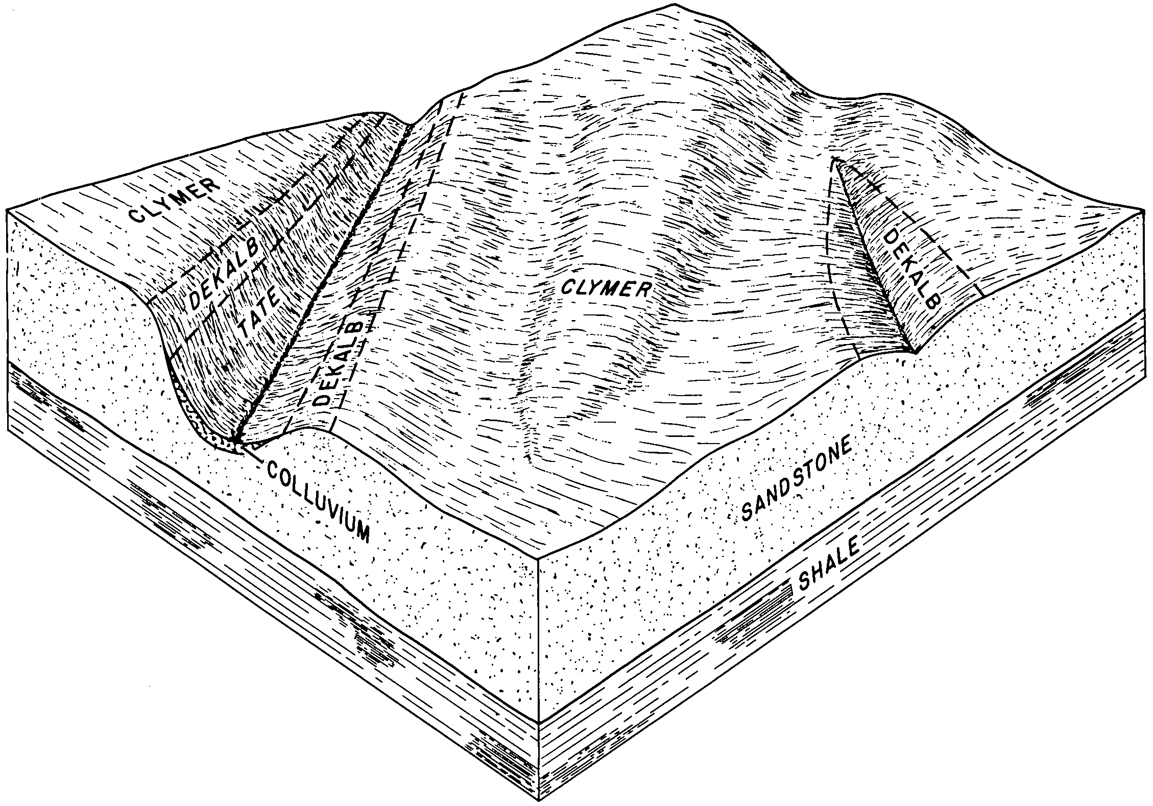
Clymer-Dekalb complex, very steep | CDF | 212047 | 512830 | k6mx | wv039 | 1976 | 1:20000 |
Clymer-Dekalb complex, steep | CDE | 23557 | 512829 | k6mw | wv039 | 1976 | 1:20000 |
Clymer-Dekalb complex, moderately steep | CDD | 6449 | 512828 | k6mv | wv039 | 1976 | 1:20000 |
Clymer loam, 10 to 15 percent slopes | CaC | 510 | 512831 | k6my | wv039 | 1976 | 1:20000 |
Clymer loam, 3 to 8 percent slopes | CmB | 2944 | 1864228 | 20kwd | wv077 | 1955 | 1:20000 |
Clymer loam, 8 to 15 percent slopes | CmC | 456 | 1864229 | 20kwf | wv077 | 1955 | 1:20000 |
Clymer gravelly loam, 3 to 8 percent slopes | CkB | 194 | 1864226 | 20kwb | wv077 | 1955 | 1:20000 |
Clymer loam, 0 to 3 percent slopes | CmA | 123 | 1864227 | 20kwc | wv077 | 1955 | 1:20000 |
Clymer and Wharton soils, 3 to 15 percent slopes, very rubbly | CWC | 55 | 1675007 | 1t6zh | wv602 | 1965 | 1:20000 |
Clymer and Wharton rubbly soils, 3 to 15 percent slopes | CwB | 6401 | 515890 | k9tm | wv628 | 1980 | 1:20000 |
Clymer and Wharton rubbly soils, 15 to 35 percent slopes | CwD | 3987 | 515891 | k9tn | wv628 | 1980 | 1:20000 |
Clymer stony loam, 3 to 15 percent slopes | CsB | 3123 | 515888 | k9tk | wv628 | 1980 | 1:20000 |
Clymer stony loam, 15 to 35 percent slopes | CsD | 820 | 515889 | k9tl | wv628 | 1980 | 1:20000 |
Clymer-Gilpin complex, 30 to 70 percent slopes | CnF | 24043 | 2516578 | k9xw | wv713 | | 1:24000 |
Clymer-Gilpin complex, 15 to 30 percent slopes | CnD | 4602 | 2516577 | k9xv | wv713 | | 1:24000 |