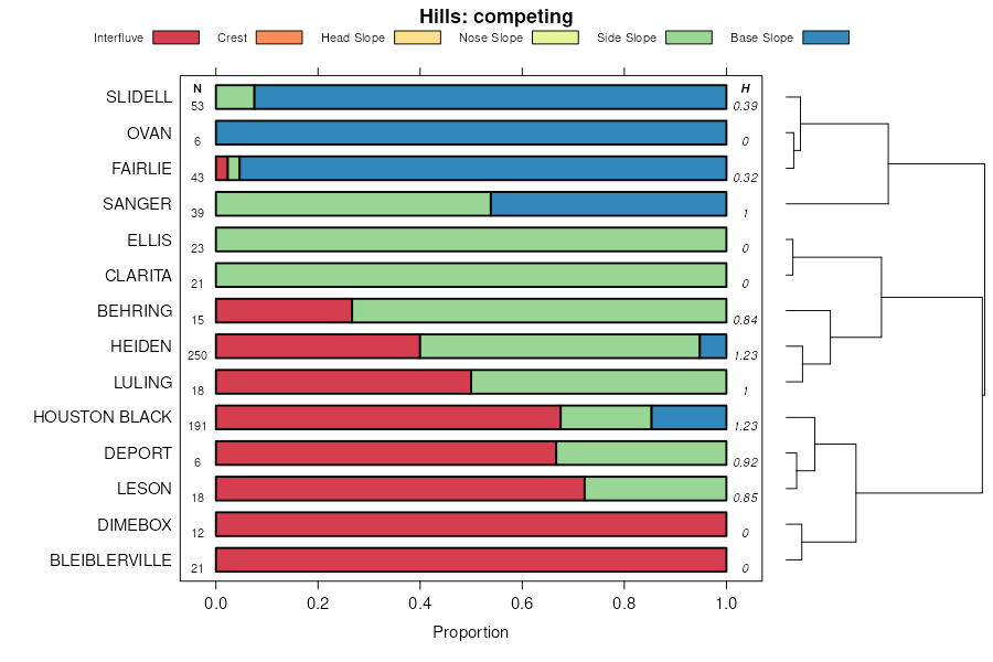
| Burleson clay, 1 to 3 percent slopes | 19 | 5343 | 571331 | m5j1 | ok005 | 1977 | 1:24000 |
Burleson clay, 0 to 1 percent slopes | 18 | 1109 | 571330 | 2ssg6 | ok005 | 1977 | 1:24000 |
Burleson clay, 1 to 3 percent slopes | 16 | 19529 | 381795 | 2tbtx | ok013 | 1974 | 1:24000 |
Burleson clay, 0 to 1 percent slopes | 15 | 6613 | 381794 | 2ssg6 | ok013 | 1974 | 1:24000 |
Burleson clay, 3 to 5 percent slopes | 17 | 4330 | 381796 | 2ssg9 | ok013 | 1974 | 1:24000 |
Burleson clay, 0 to 1 percent slopes | 4 | 1945 | 382024 | 30mz7 | ok019 | 1977 | 1:24000 |
Burleson clay, 1 to 3 percent slopes | 12 | 1051 | 571201 | 2tbtx | ok023 | 1977 | 1:24000 |
Burleson clay, 0 to 1 percent slopes | BuA | 2333 | 571586 | m5s8 | ok029 | 1969 | 1:24000 |
Burleson clay, 1 to 3 percent slopes | BuB | 2254 | 571587 | m5s9 | ok029 | 1969 | 1:24000 |
Burleson clay, 1 to 3 percent slopes | 8 | 1176 | 382615 | 30mz8 | ok049 | 1982 | 1:24000 |
Burleson clay, 1 to 3 percent slopes | 4 | 12194 | 383304 | 30mz8 | ok069 | 1976 | 1:24000 |
Burleson clay, 0 to 1 percent slopes | 3 | 1980 | 383293 | 30mz7 | ok069 | 1976 | 1:24000 |
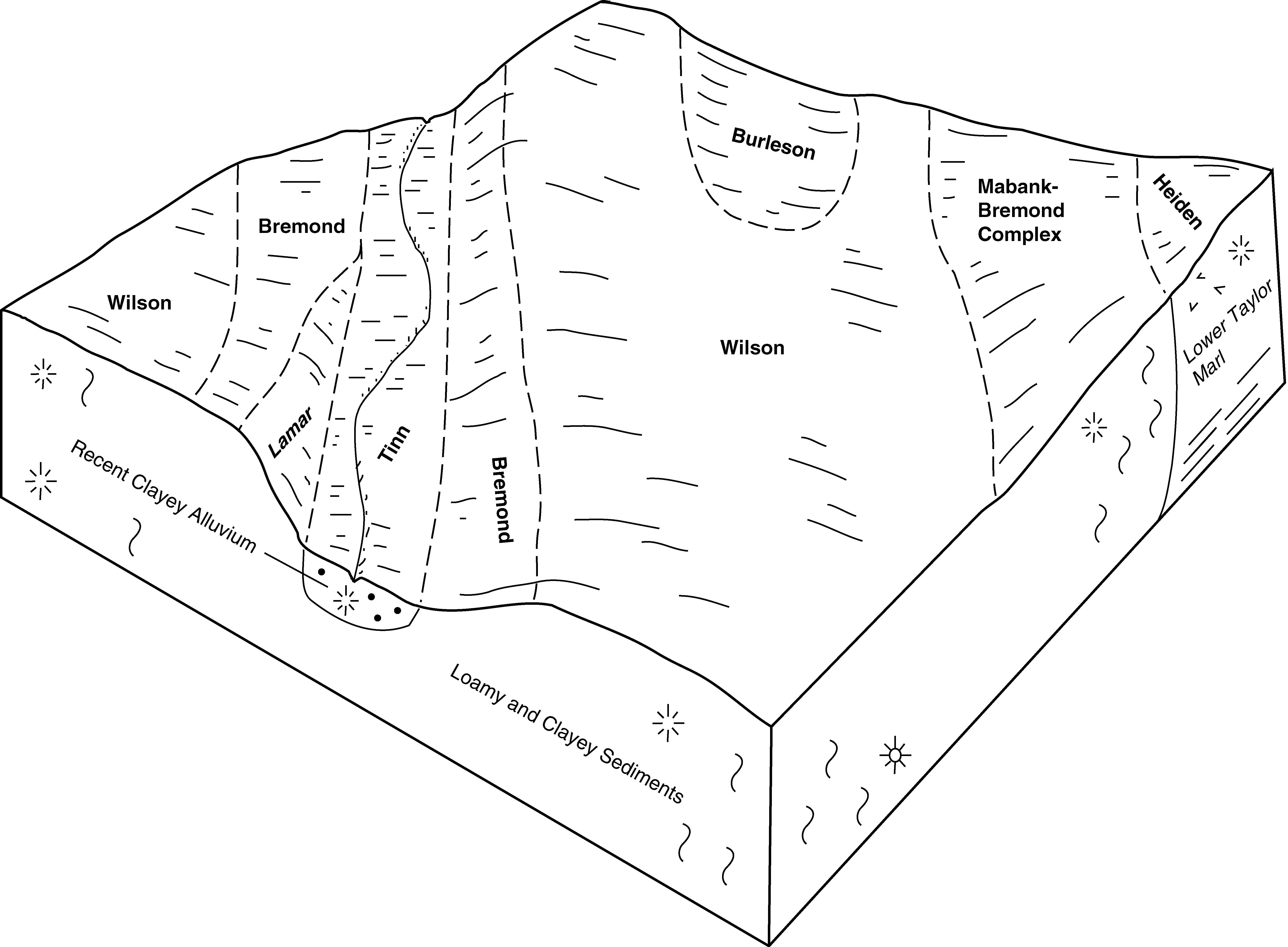
Heiden-Burleson complex, 3 to 5 percent slopes | DdC | 8372 | 383704 | dw8k | ok085 | 1963 | 1:24000 |
Burleson clay, 1 to 3 percent slopes | 3 | 8229 | 383905 | dwh1 | ok095 | 1978 | 1:24000 |
Burleson clay, 1 to 3 percent slopes | 6 | 4235 | 383968 | 30mz8 | ok099 | 1982 | 1:24000 |
Burleson clay, 1 to 3 percent slopes | BuB | 3743 | 384603 | 30mz8 | ok123 | 1967 | 1:24000 |
Burleson clay, 0 to 1 percent slopes | Bu | 1041 | 575124 | 2ssg6 | tx001 | 1970 | 1:20000 |
Burleson clay, 1 to 3 percent slopes | BuB | 1245 | 393278 | 2tbtx | tx021 | 1972 | 1:24000 |
Burleson clay, 0 to 1 percent slopes | BuA | 3880 | 391078 | 2ssg6 | tx027 | 1972 | 1:24000 |
Wilson-Burleson complex, 0 to 1 percent slopes | WnbA | 2807 | 3130039 | 2s1ry | tx027 | 1972 | 1:24000 |
Wilson-Burleson complex, 1 to 3 percent slopes | WnbB | 2389 | 3130066 | 2s1rz | tx027 | 1972 | 1:24000 |
Burleson clay, 1 to 3 percent slopes | BuB | 1392 | 391079 | 2tbtx | tx027 | 1972 | 1:24000 |
Burleson clay, 1 to 3 percent slopes, gravelly | BugB | 296 | 3130038 | 2s1qr | tx027 | 1972 | 1:24000 |
Burleson clay, 0 to 1 percent slopes | BuA | 3031 | 363180 | 2ssg6 | tx041 | 1993 | 1:20000 |
Burleson clay, 1 to 3 percent slopes | BuB | 2309 | 363181 | 2tbtx | tx041 | 1993 | 1:20000 |
Burleson clay, 3 to 5 percent slopes | BuC | 872 | 363182 | 2ssg9 | tx041 | 1993 | 1:20000 |
Burleson clay, 0 to 1 percent slopes | BuA | 4430 | 363430 | 2ssg6 | tx051 | 1994 | 1:24000 |
Burleson clay, 1 to 3 percent slopes | BuB | 1171 | 363431 | 2tbtx | tx051 | 1994 | 1:24000 |
Burleson clay, 3 to 5 percent slopes | BuC | 442 | 363432 | 2ssg9 | tx051 | 1994 | 1:24000 |
Burleson clay, 1 to 3 percent slopes | BuB | 5728 | 363497 | 2tbtx | tx055 | 1972 | 1:20000 |
Burleson clay, 0 to 1 percent slopes | BuA | 1813 | 363496 | 2ssg6 | tx055 | 1972 | 1:20000 |
Burleson clay, 1 to 3 percent slopes | BcB | 11453 | 364060 | 2tbtx | tx085 | 1965 | 1:20000 |
Burleson clay, 0 to 1 percent slopes | BcA | 4448 | 364059 | 2ssg6 | tx085 | 1965 | 1:20000 |
Burleson clay, 0 to 1 percent slopes | BuA | 2996 | 364258 | 2ssg6 | tx089 | 1997 | 1:24000 |
Burleson clay, 1 to 3 percent slopes | BuB | 237 | 364259 | 2tbtx | tx089 | 1997 | 1:24000 |
Burleson clay, 0 to 1 percent slopes | 18 | 5881 | 364798 | 2ssg6 | tx113 | 1975 | 1:20000 |
Burleson clay, 1 to 3 percent slopes | 19 | 4849 | 364799 | 2tbtx | tx113 | 1975 | 1:20000 |
Burleson clay, 1 to 3 percent slopes | 22 | 13622 | 364972 | 2tbtx | tx121 | 1975 | 1:24000 |
Burleson clay, 0 to 1 percent slopes | 21 | 8597 | 364971 | 2ssg6 | tx121 | 1975 | 1:24000 |
Burleson clay, 0 to 1 percent slopes | BuA | 9911 | 365284 | 2ssg6 | tx139 | 1962 | 1:20000 |
Burleson clay, 1 to 3 percent slopes | BtB | 4573 | 365283 | 2tbtx | tx139 | 1962 | 1:20000 |
Burleson clay, depressional | By | 323 | 365286 | d83f | tx139 | 1962 | 1:20000 |
Burleson clay, 0 to 1 percent slopes | 16 | 11014 | 365433 | 2ssg6 | tx145 | 1975 | 1:20000 |
Burleson clay, 1 to 3 percent slopes | 17 | 2609 | 365434 | 2tbtx | tx145 | 1975 | 1:20000 |
Burleson clay, 0 to 1 percent slopes | BuA | 4142 | 365505 | 2ssg6 | tx147 | 1989 | 1:24000 |
Burleson clay, 0 to 1 percent slopes | BuA | 1561 | 365692 | 2ssg6 | tx149 | 1991 | 1:24000 |
Burleson clay, 0 to 1 percent slopes | BuA | 593 | 375373 | 2ssg6 | tx161 | 1986 | 1:24000 |
Burleson clay, 0 to 1 percent slopes | BsA | 1353 | 366743 | 2ssg6 | tx185 | 1988 | 1:24000 |
Burleson gravelly clay, 1 to 3 percent slopes | ByB | 2149 | 366844 | 2ssgb | tx187 | 1973 | 1:20000 |
Burleson gravelly clay, 0 to 1 percent slopes | ByA | 1106 | 366843 | d9qn | tx187 | 1973 | 1:20000 |
Burleson clay, 0 to 1 percent slopes | BuA | 761 | 366842 | 2ssg6 | tx187 | 1973 | 1:20000 |
Burleson clay, 0 to 1 percent slopes | 5 | 1949 | 367639 | 2ssg6 | tx213 | 1978 | 1:20000 |
Burleson clay, 0 to 1 percent slopes | 22 | 3355 | 367734 | 2ssg6 | tx217 | 1975 | 1:20000 |
Wilson-Burleson complex, 0 to 1 percent slopes | 81 | 3116 | 367799 | dbqh | tx217 | 1975 | 1:20000 |
Burleson clay, 1 to 3 percent slopes | 23 | 1022 | 367735 | 2tbtx | tx217 | 1975 | 1:20000 |
Burleson clay, 0 to 1 percent slopes | 5 | 8709 | 367897 | 2ssg6 | tx231 | 1978 | 1:24000 |
Burleson clay, 0 to 1 percent slopes | BuA | 1549 | 368155 | 2ssg6 | tx251 | 1981 | 1:20000 |
Burleson clay, 1 to 3 percent slopes | BuB | 1376 | 368156 | 2tbtx | tx251 | 1981 | 1:20000 |
Burleson clay, 0 to 1 percent slopes | BuA | 1594 | 369176 | 2ssg6 | tx289 | 1985 | 1:24000 |
Burleson clay, 1 to 3 percent slopes | BuB | 1088 | 369177 | 2tbtx | tx289 | 1985 | 1:24000 |
Burleson clay, 0 to 2 percent slopes | BuA | 6108 | 369385 | 2ssg7 | tx293 | 1991 | 1:24000 |
Burleson clay, 0 to 1 percent slopes | BuA | 12450 | 370082 | 2ssg6 | tx309 | 1992 | 1:24000 |
Burleson clay, 0 to 1 percent slopes | BuA | 1314 | 370273 | 2ssg6 | tx313 | 1989 | 1:24000 |
Burleson clay, 0 to 2 percent slopes | BurA | 15760 | 370664 | 2ssg7 | tx331 | 1988 | 1:24000 |
Burleson clay, 0 to 1 percent slopes | BuA | 1632 | 3130071 | 2ssg6 | tx331 | 1988 | 1:24000 |
Burleson clay, 1 to 3 percent slopes | BuB | 680 | 3130072 | 2tbtx | tx331 | 1988 | 1:24000 |
Wilson-Burleson complex, 0 to 1 percent slopes | WnbA | 394 | 3130073 | 2s1ry | tx331 | 1988 | 1:24000 |
Wilson-Burleson complex, 1 to 3 percent slopes | WnbB | 250 | 3130096 | 2s1rz | tx331 | 1988 | 1:24000 |
Burleson clay, 1 to 3 percent slopes | Bu | 2122 | 575572 | 2tbtx | tx339 | 1967 | 1:20000 |
Burleson clay, 0 to 1 percent slopes | BuA | 22616 | 370917 | 2ssg6 | tx349 | 1968 | 1:24000 |
Burleson clay, 1 to 3 percent slopes | BuB | 14656 | 370918 | 2tbtx | tx349 | 1968 | 1:24000 |
Burleson clay, 1 to 3 percent slopes | BuB | 25965 | 371431 | 2tbtx | tx387 | 1972 | 1:24000 |
Burleson clay, 0 to 1 percent slopes | BuA | 2334 | 371430 | 2ssg6 | tx387 | 1972 | 1:24000 |
Burleson clay, 0 to 1 percent slopes | BuA | 1066 | 371697 | 2ssg6 | tx395 | 1996 | 1:24000 |
Burleson clay, 0 to 1 percent slopes | BuA | 1232 | 372363 | 2ssg6 | tx439 | 1979 | 1:20000 |
Burleson gravelly clay, 1 to 3 percent slopes | BtB | 3426 | 392172 | 2ssgb | tx453 | 1969 | 1:20000 |
Burleson gravelly clay, 3 to 5 percent slopes | BtC | 2916 | 392173 | f52r | tx453 | 1969 | 1:20000 |
Burleson clay, 1 to 3 percent slopes | BsB | 2618 | 392171 | 2tbtx | tx453 | 1969 | 1:20000 |
Burleson clay, 0 to 1 percent slopes | BsA | 961 | 392170 | 2ssg6 | tx453 | 1969 | 1:20000 |
Burleson clay, 0 to 1 percent slopes | 12 | 540 | 373138 | 2ssg6 | tx477 | 1979 | 1:24000 |
Burleson clay, 1 to 3 percent slopes | 13 | 472 | 373139 | 2tbtx | tx477 | 1979 | 1:24000 |
Burleson clay, 0 to 1 percent slopes | BuA | 18320 | 373529 | 2ssg6 | tx491 | 1981 | 1:20000 |
Burleson clay, 1 to 3 percent slopes | BuB | 3620 | 373530 | 2tbtx | tx491 | 1981 | 1:20000 |
Wilson-Burleson complex, 1 to 3 percent slopes | WnbB | 1576 | 3130130 | 2s1rz | tx491 | 1981 | 1:20000 |
Wilson-Burleson complex, 0 to 1 percent slopes | WnbA | 1066 | 3130105 | 2s1ry | tx491 | 1981 | 1:20000 |
Burleson clay, 1 to 3 percent slopes, gravelly | BugB | 214 | 3130104 | 2s1qr | tx491 | 1981 | 1:20000 |
Burleson clay, 0 to 1 percent slopes | BuA | 2975 | 373819 | 2ssg6 | tx600 | 1981 | 1:24000 |
Burleson clay, 1 to 3 percent slopes | BuB | 22874 | 374466 | 2tbtx | tx612 | 1973 | 1:20000 |
Burleson clay, 0 to 1 percent slopes | BuA | 8786 | 374465 | 2ssg6 | tx612 | 1973 | 1:20000 |
Burleson clay, 0 to 1 percent slopes | 8 | 5038 | 393338 | 2ssg6 | tx614 | 1975 | 1:20000 |


