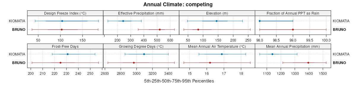
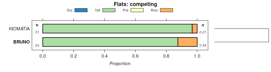
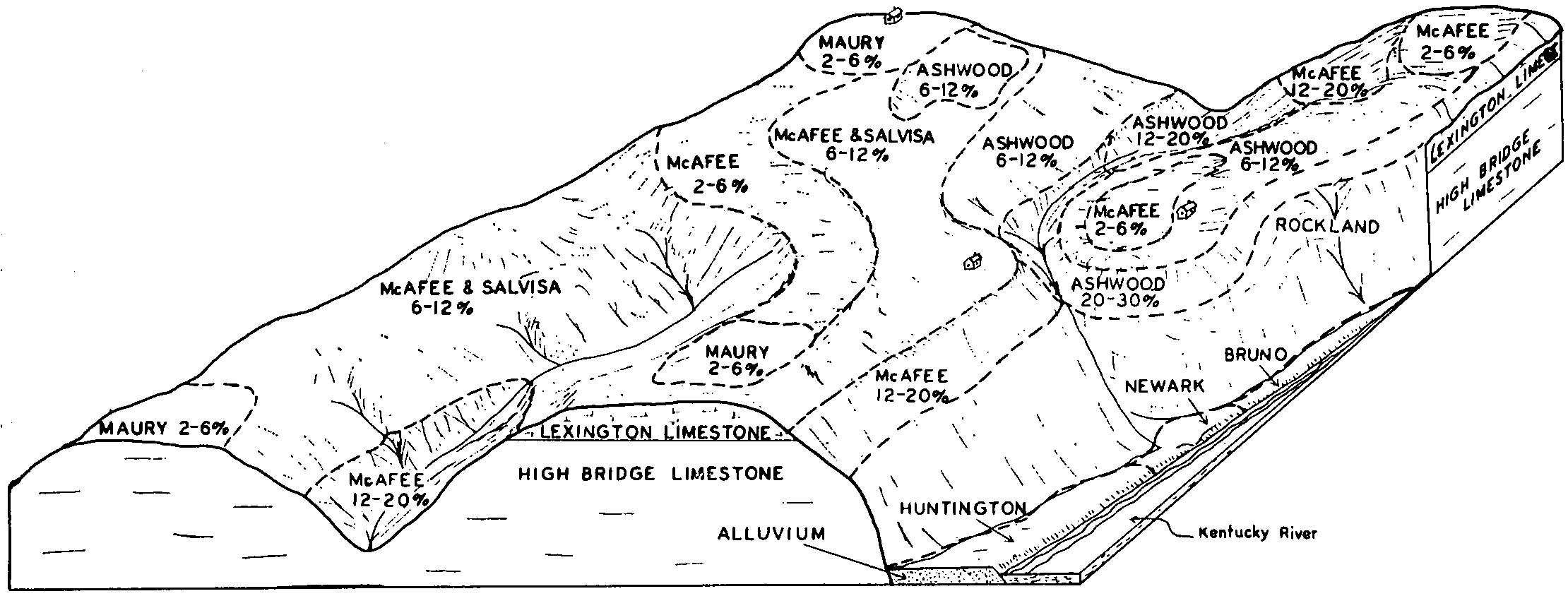
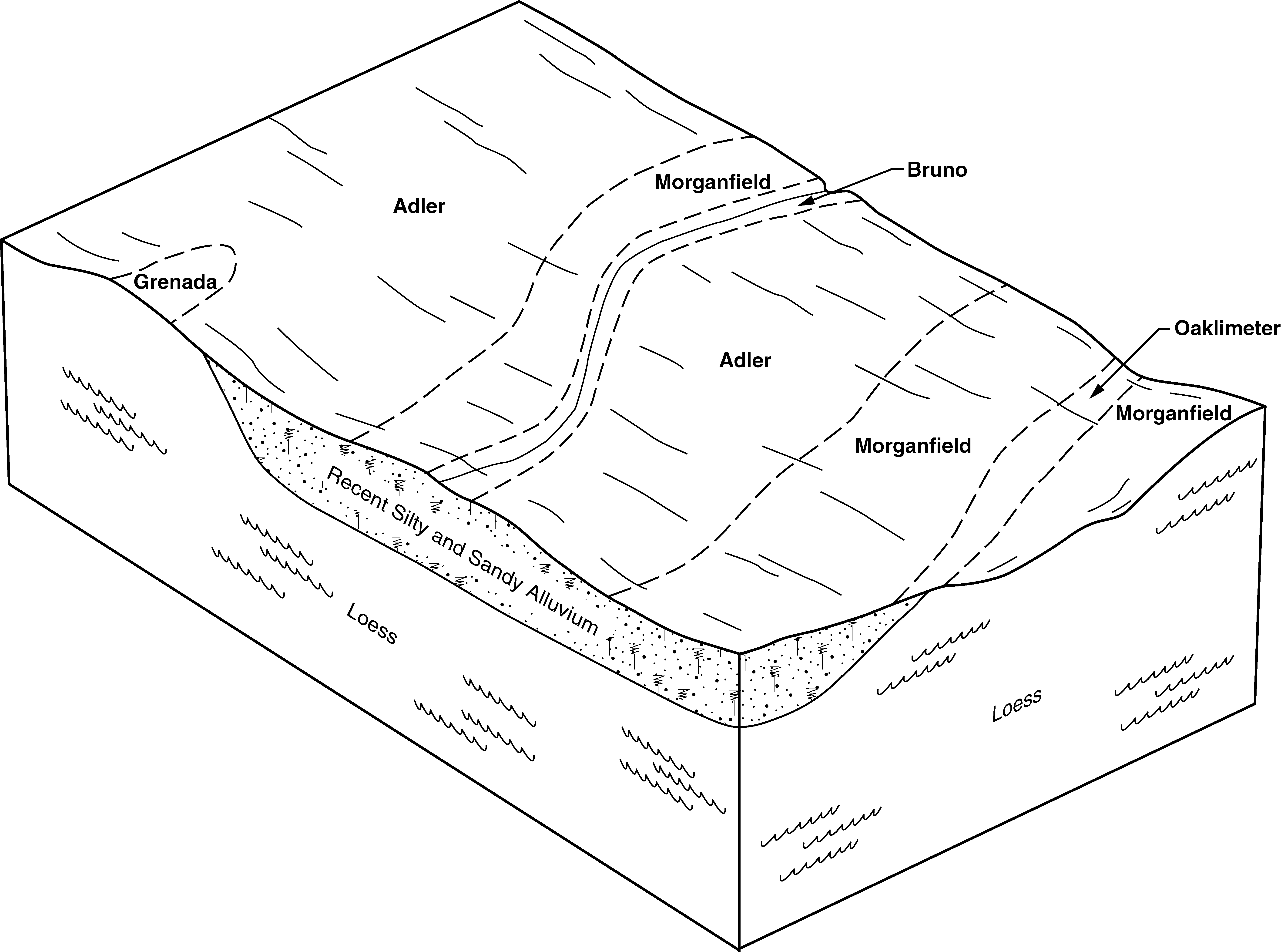
| Bruno loamy sand | Bu | 810 | 329318 | c1p5 | al053 | 1969 | 1:20000 |
Bruno fine sandy loam | Bf | 4567 | 522821 | kk16 | al071 | 1943 | 1:24000 |
Bruno loamy fine sand | Bu | 331 | 522822 | kk17 | al071 | 1943 | 1:24000 |
Bruno loamy fine sand | Bd | 1075 | 330083 | c2gv | al079 | 1950 | 1:20000 |
Bruno fine sandy loam | Bf | 680 | 522720 | kjxy | al083 | 1953 | 1:20000 |
Riverview-Bruno complex, 0 to 3 percent slopes, occasionally flooded | RoB | 2223 | 330488 | c2wx | al087 | 1997 | 1:24000 |
Bruno loamy fine sand | Br | 189 | 523083 | kk9n | al089 | 1958 | 1:24000 |
Sandy alluvial land, excessively drained | Sa | 56 | 330746 | c357 | al095 | 1956 | 1:20000 |
Bruno loamy fine sand | Bb | 723 | 331033 | c3gh | al103 | 1949 | 1:15840 |
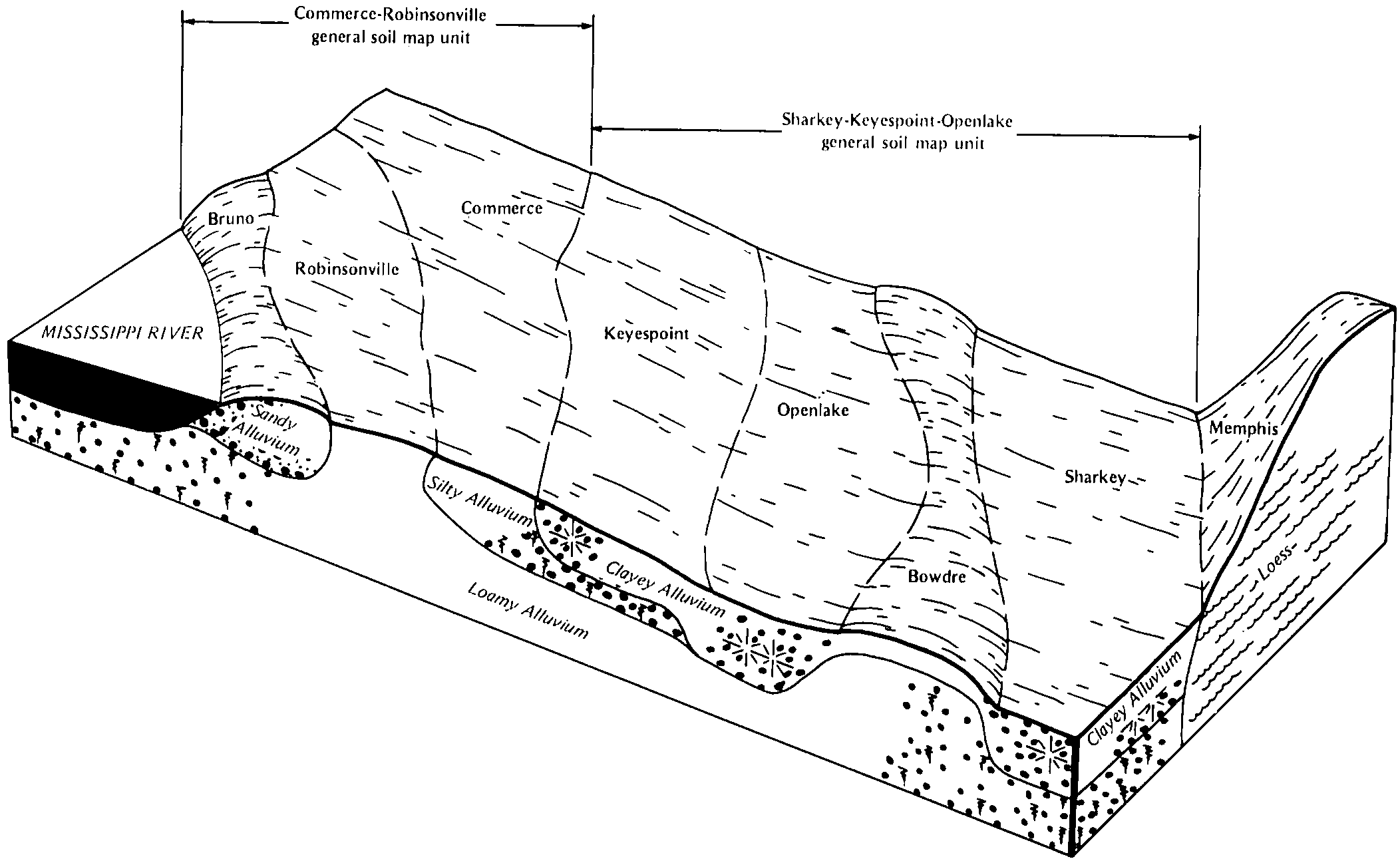
Dundee-Bruno-Commerce complex | 20 | 13870 | 564127 | ly0n | ar031 | 1976 | 1:20000 |
Bruno loamy sand | 7 | 1970 | 564152 | ly1g | ar031 | 1976 | 1:20000 |
Bruno loamy sand, gently undulating | BrU | 2229 | 564187 | ly2l | ar041 | 1968 | 1:20000 |
Bruno and Iuka soils | Bu | 9433 | 565532 | lzgz | ar047 | 1967 | 1:20000 |
Bruno loamy fine sand | Br | 3155 | 565531 | lzgy | ar047 | 1967 | 1:20000 |
Bruno loamy fine sand | Br | 2609 | 565823 | lzsc | ar071 | 1973 | 1:24000 |
Bruno soils, frequently flooded | Bs | 1650 | 564075 | lxyz | ar077 | 1974 | 1:20000 |
Bruno fine sandy loam, gently undulating | BrB | 400 | 564074 | lxyy | ar077 | 1974 | 1:20000 |
Bruno-Crevasse complex | Bv | 4860 | 564337 | ly7f | ar093 | 1967 | 1:20000 |
Bruno loamy fine sand, 0 to 3 percent slopes | 2 | 3818 | 566124 | m032 | ar115 | 1978 | 1:20000 |
Bruno loamy fine sand, occasionally flooded | 3 | 3249 | 566135 | m03f | ar115 | 1978 | 1:20000 |
Bruno fine sandy loam | Bs | 9044 | 566167 | m04g | ar119 | 1972 | 1:20000 |
Bruno-Urban land complex | Bu | 579 | 566168 | m04h | ar119 | 1972 | 1:20000 |
Bruno loamy sand, undulating | Br | 1370 | 564434 | lybk | ar123 | 1964 | 1:20000 |
Bruno loamy fine sand, 0 to 3 percent slopes, occasionally flooded | 6 | 2836 | 565015 | lyy9 | ar149 | 1985 | 1:20000 |
Bruno loamy fine sand, 0 to 3 percent slopes | 5 | 602 | 565010 | lyy4 | ar149 | 1985 | 1:20000 |
Crevasse and Bruno soils, gently undulating, frequently flooded | CVB | 8114 | 577253 | mcp2 | la107 | 2001 | 1:24000 |
Bruno and Vicksburg soils | Bv | 3584 | 567400 | m1f7 | ms001 | 1966 | 1:15840 |
Crevasse-Bruno complex | Cx | 1941 | 567408 | m1fh | ms001 | 1966 | 1:15840 |
Bruno loamy fine sand | Bu | 1401 | 567399 | m1f6 | ms001 | 1966 | 1:15840 |
Bruno soils | Br | 525 | 567437 | m1gf | ms005 | 1971 | 1:20000 |
Bruno sandy loam, occasionally flooded | 13 | 8578 | 567524 | m1k7 | ms015 | 1985 | 1:20000 |
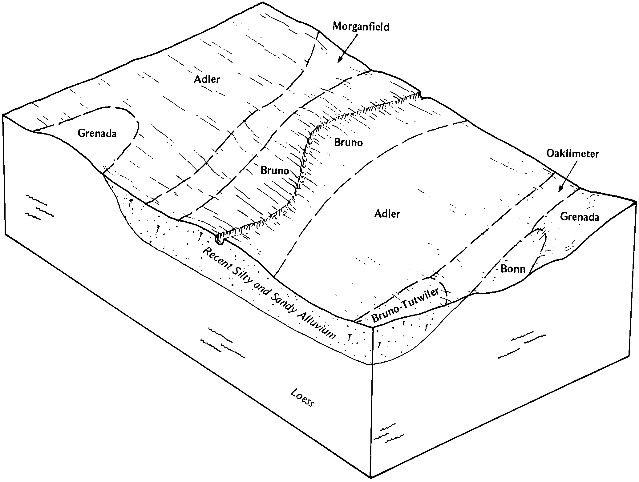
Bruno-Tutwiler complex | 19 | 2408 | 567527 | m1kb | ms015 | 1985 | 1:20000 |
Bruno sandy loam | Br | 5974 | 567674 | m1q2 | ms029 | 1981 | 1:20000 |
Bruno sandy loam, occasionally flooded | 12 | 8079 | 567799 | m1v3 | ms037 | 1992 | 1:20000 |
Bruno sandy loam, frequently flooded | 9 | 1094 | 567826 | m1vz | ms037 | 1992 | 1:20000 |
Bruno sandy loam, occasionally flooded | Br | 4275 | 567949 | m1zy | ms051 | 1997 | 1:20000 |
Bruno sandy loam, frequently flooded | Bu | 1415 | 567950 | m1zz | ms051 | 1997 | 1:20000 |
Bruno sandy loam | Bu | 2526 | 568071 | m23w | ms063 | 1976 | 1:20000 |
Ochlockonee-Bruno association, frequently flooded | 40 | 5792 | 332826 | c5bb | ms071 | 1979 | 1:20000 |
Ochlockonee-Bruno complex, frequently flooded | 41 | 335 | 332827 | c5bc | ms071 | 1979 | 1:20000 |
Bruno loamy sand, 0 to 2 percent slopes, occasionally flooded | 15 | 1037 | 568106 | m250 | ms083 | 1997 | 1:24000 |
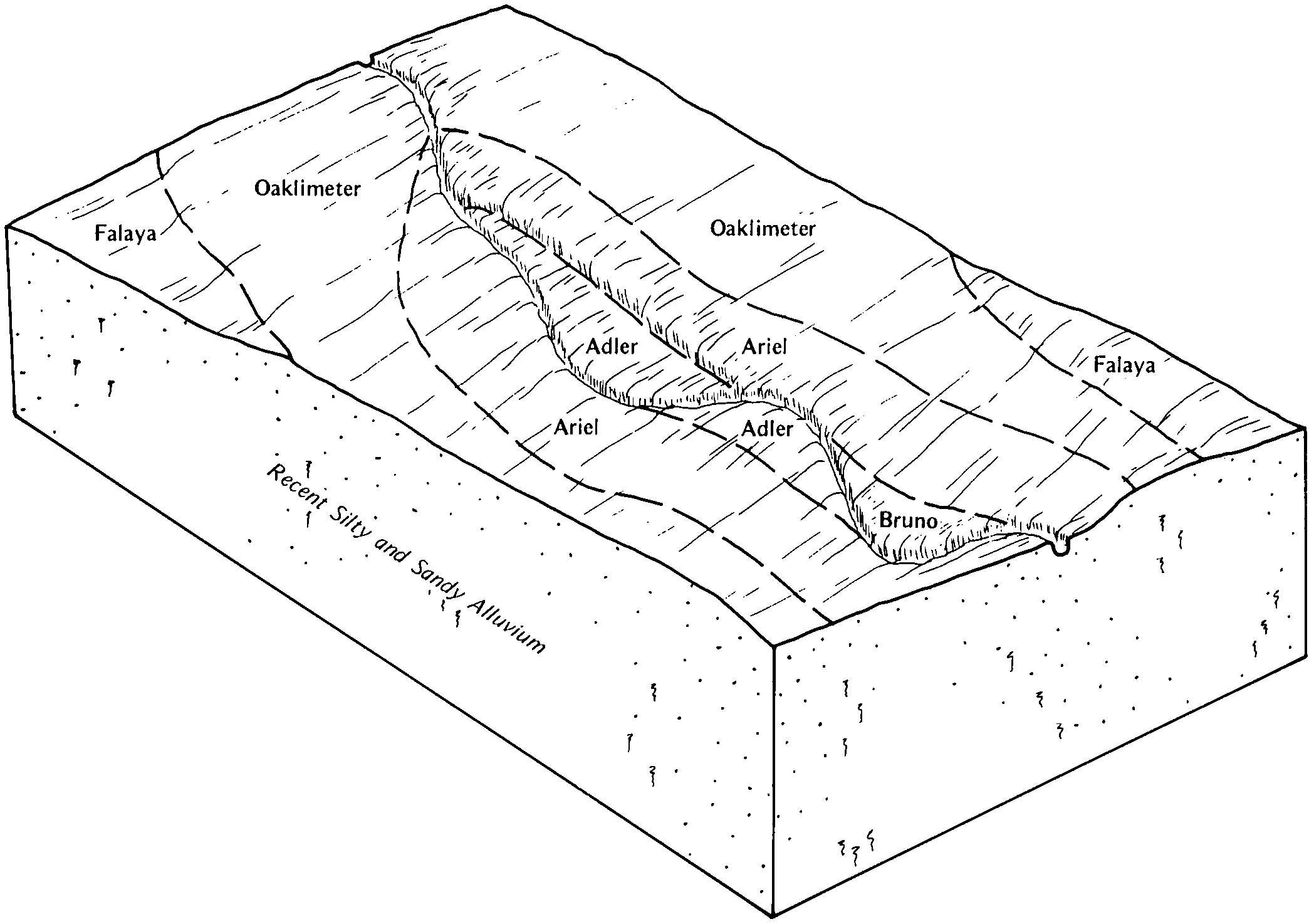
Bruno-Ariel complex | Bc | 977 | 568209 | m28b | ms089 | 1981 | 1:20000 |
Collins-Arkabutla-Bruno association | CN | 4019 | 568263 | m2b2 | ms093 | 1968 | 1:20000 |
Bruno soils | Bu | 602 | 333236 | c5rk | ms097 | 1971 | 1:20000 |
Mixed alluvial land (bruno and Collins soils, frequently flooded) | Mx | 14721 | 568344 | m2dp | ms107 | 1961 | 1:24000 |
Ochlockonee and Bruno soils | Ob | 588 | 333646 | c65s | ms113 | 1965 | 1:15840 |
Bruno loamy sand, frequently flooded | Br | 3337 | 333954 | c6hq | ms127 | 1993 | 1:20000 |
Vicksburg and Bruno soils | Vk | 3170 | 568551 | m2mc | ms135 | 1966 | 1:24000 |
Tutwiler-Bruno complex, 0 to 5 percent slopes | TwB | 1727 | 568549 | m2m9 | ms135 | 1966 | 1:24000 |
Crevasse and Bruno soils | Cs | 369 | 568512 | m2l3 | ms135 | 1966 | 1:24000 |
Bruno loamy fine sand, 2 to 8 percent slopes, frequently flooded | 73 | 1588 | 1715953 | 1vllb | ms143 | 2006 | 1:24000 |
Bruno loamy fine sand, 0 to 2 percent slopes, frequently flooded | 71 | 1275 | 1715952 | 1vll9 | ms143 | 2006 | 1:24000 |
Bruno loamy sand (nugent) | Br | 313 | 334300 | c6vw | ms147 | 1965 | 1:20000 |
Bruno sandy loam | Br | 299 | 334445 | c70k | ms155 | 1974 | 1:20000 |
Bruno loamy fine sand, 0 to 5 percent slopes, frequently flooded | 4C | 2253 | 571062 | m57c | ms157 | 2006 | 1:24000 |
Bruno sandy loam, occasionally flooded | Br | 1230 | 334639 | c76t | ms161 | 1975 | 1:20000 |
Bruno sandy loam, frequently flooded | Bu | 140 | 334640 | c76v | ms161 | 1975 | 1:20000 |
Bruno-Morganfield complex, frequently flooded | Bm | 401 | 2693466 | 2rv58 | ms163 | 1969 | 1:20000 |
Bruno loamy fine sand | Bf | 187 | 526857 | kp7d | tn011 | 1951 | 1:20000 |
Bruno loamy fine sand | Br | 93 | 524870 | km59 | tn031 | 1956 | 1:20000 |
BRUNO FINE SANDY LOAM | Bp | 579 | 327272 | bzk5 | tn039 | 2008 | 1:24000 |
BRUNO LOAMY FINE SAND | Br | 190 | 327273 | bzk6 | tn039 | 2008 | 1:24000 |
Sandy alluvial land (Bruno) | Sa | 1782 | 567029 | m118 | tn047 | 1961 | 1:15840 |
Bruno loamy fine sand | Bu | 661 | 527155 | kpk0 | tn051 | 1950 | 1:20000 |
Bruno loamy fine sand | Bu | 506 | 327526 | bztc | tn071 | 1961 | 1:15840 |
Sandy alluvial land (Bruno) | Rk | 539 | 327786 | c02r | tn077 | 1955 | 1:20000 |
Bruno loamy fine sand | Br | 284 | 527514 | kpxl | tn083 | 1952 | 1:20000 |
Bruno soils and alluvial land | Bu | 3353 | 567121 | m147 | tn095 | 1966 | 1:20000 |
Reelfoot-Bruno complex | Rb | 1724 | 567129 | m14h | tn095 | 1966 | 1:20000 |
Bruno loamy fine sand, occasionally flooded | Br | 3509 | 567147 | m152 | tn097 | 1985 | 1:24000 |
Bruno silty clay loam, overwash, occasionally flooded | Bs | 755 | 567148 | m153 | tn097 | 1985 | 1:24000 |
Bruno loamy fine sand | Bh | 216 | 526235 | knlb | tn115 | 1951 | 1:20000 |
Crevasse silt loam (Bruno overwash) | Cv | 585 | 567288 | m19m | tn157 | 1966 | 1:15840 |
Bruno silt loam, frequently flooded | Br | 2782 | 567331 | m1c0 | tn167 | 1989 | 1:24000 |
Bruno loamy sand | Br | 431 | 529864 | kscd | tn177 | 1965 | 1:15840 |
Bruno sandy loam, frequently flooded | By | 213 | 328008 | c09x | tn181 | 1996 | 1:24000 |
Bruno loamy fine sand | Bg | 395 | 1899450 | 21rjl | tn609 | 1955 | 1:20000 |
Bruno loamy sand | Br | 206 | 2427409 | 2mgxj | tn610 | 1960 | 1:15840 |
Bruno loamy fine sand | Br | 693 | 575571 | m9xt | tx339 | 1967 | 1:20000 |


