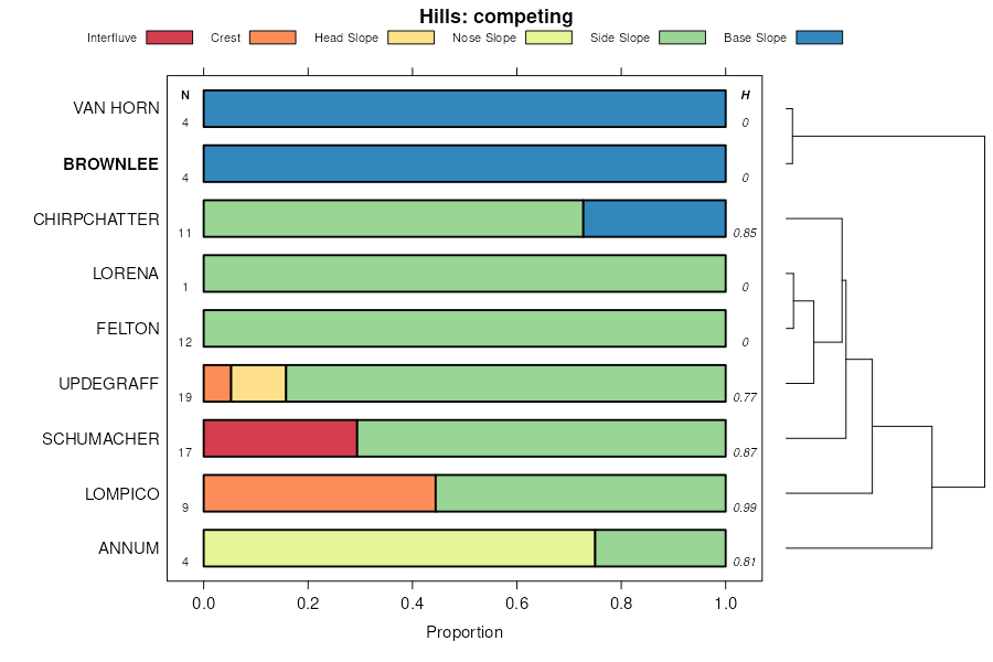
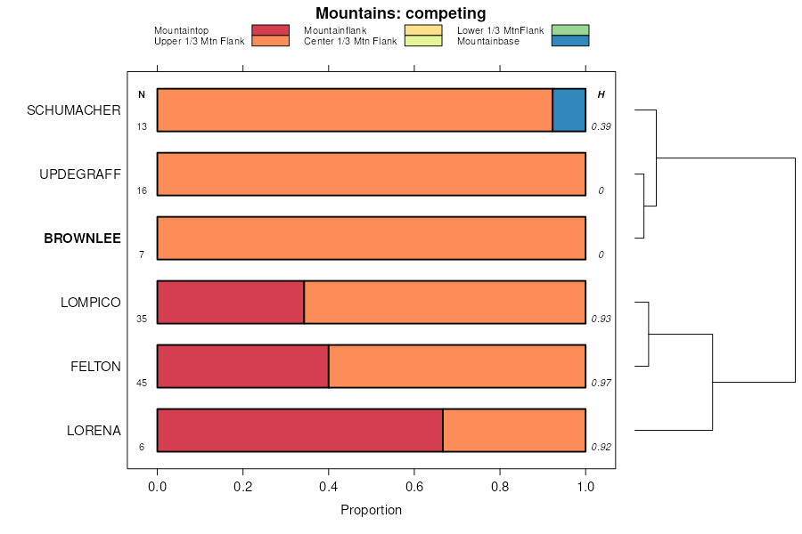
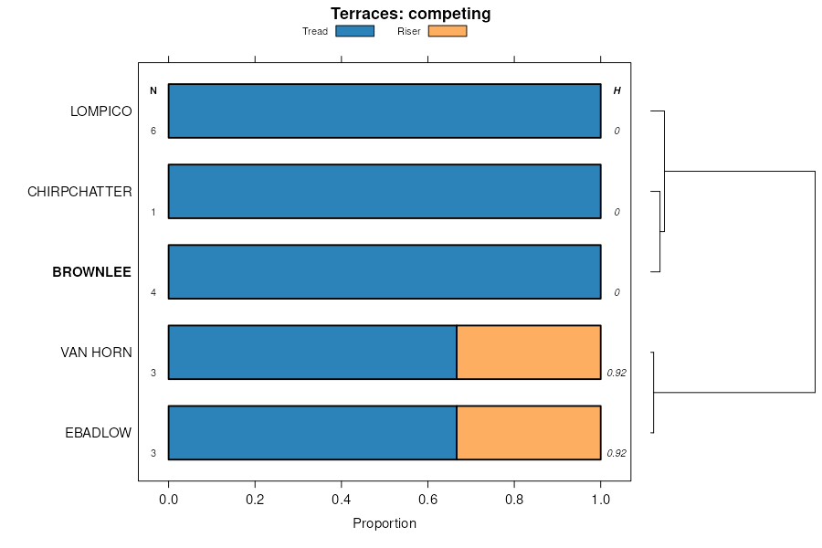
| Brownlee-Bobbitt families association, 0 to 35 percent slopes. | 15la | 6781 | 3059815 | ht35 | ca707 | 1983 | 1:24000 |
Bobbitt-Holland-Brownlee families association,35 to 50 percent slopes. | 9la | 2981 | 3059829 | ht2z | ca707 | 1983 | 1:24000 |
Bobbitt- Brownlee-Alicel families comples, 0 to 35 percent slopes | 5 | 12158 | 470978 | ht2v | ca708 | 1984 | 1:24000 |
Brownlee-Skalan families association, 0 to 35 percent slopes. | 16 | 4298 | 470989 | ht36 | ca708 | 1984 | 1:24000 |
Brownlee-Bobbitt families association, 0 to 35 percent slopes. | 15 | 1316 | 470988 | ht35 | ca708 | 1984 | 1:24000 |
Brownlee family-Hotaw variant complex, 30 to 50 percent slopes | 601 | 5719 | 465210 | hm2s | ca760 | 1981 | 1:24000 |
Hotaw variant-Brownlee family-Rock outcrop complex, 40 to 75 percent slopes | 635 | 3064 | 465229 | hm3d | ca760 | 1981 | 1:24000 |
Robbscreek-Dobson-Brownlee complex, 25 to 65 percent slopes | 5025 | 4903 | 2519245 | 2162p | id001 | 2012 | 1:24000 |
Cartwright-Brownlee-Robbscreek complex, 25 to 65 percent slopes | 5026 | 2003 | 2519246 | 2162q | id001 | 2012 | 1:24000 |
Brownlee-Robbscreek-Whisk complex, 8 to 35 percent slopes | 5006 | 1814 | 2519242 | 2162k | id001 | 2012 | 1:24000 |
Borid-Shanks-Brownlee complex, 25 to 65 percent slopes | 5031 | 1750 | 2519250 | 2166v | id001 | 2012 | 1:24000 |
Kisky-Shimo-Brownlee complex, 35 to 90 percent slopes | 5056 | 450 | 2519259 | 21631 | id001 | 2012 | 1:24000 |
Brower-Brownlee complex, 12 to 40 percent slopes | 14 | 39 | 3253828 | 5577 | id600 | 1989 | 1:24000 |
Brower-Brownlee complex, 12 to 40 percent slopes | 14 | 11 | 2686323 | 5577 | id609 | 1989 | 1:24000 |
Brownlee loam, 12 to 25 percent slopes | 18 | 1766 | 153989 | 557d | id617 | 1976 | 1:24000 |
Brower-Brownlee complex, 12 to 40 percent slopes | 14 | 1586 | 153984 | 5577 | id617 | 1976 | 1:24000 |
Brownlee loam, 25 to 40 percent slopes | 19 | 630 | 153990 | 557f | id617 | 1976 | 1:24000 |
Brownlee loam, 7 to 12 percent slopes | 17 | 395 | 153988 | 557c | id617 | 1976 | 1:24000 |
Brownlee loam, 2 to 7 percent slopes | 16 | 181 | 153987 | 557b | id617 | 1976 | 1:24000 |
Deshler-Brownlee complex, 8 to 20 percent slopes | 56 | 7158 | 81251 | 2qk0 | id656 | 1992 | 1:24000 |
Deshler-Brownlee complex, 20 to 30 percent slopes | 57 | 6350 | 81252 | 2qk1 | id656 | 1992 | 1:24000 |
Brownlee sandy loam, 20 to 35 percent slopes | 26 | 5873 | 81218 | 2qhy | id656 | 1992 | 1:24000 |
Brownlee sandy loam, 8 to 20 percent slopes | 25 | 5270 | 81217 | 2qhx | id656 | 1992 | 1:24000 |
Brownlee sandy loam, 4 to 8 percent slopes | 24 | 4473 | 81216 | 2qhw | id656 | 1992 | 1:24000 |
Deshler-Brownlee complex, 2 to 8 percent slopes | 55 | 3962 | 81250 | 2qjz | id656 | 1992 | 1:24000 |
Brownlee loam, 1 to 4 percent slopes | 27 | 1583 | 81219 | 2qhz | id656 | 1992 | 1:24000 |
Brownlee and Ola soils, 30 to 60 percent slopes | BtF | 3665 | 80509 | 2ps2 | id660 | 1962 | 1:15840 |
Brownlee and Rainey soils, 12 to 30 percent slopes | BuE | 3030 | 80511 | 2ps4 | id660 | 1962 | 1:15840 |
Brownlee loam, 12 to 30 percent slopes | BsE | 1587 | 80508 | 2ps1 | id660 | 1962 | 1:15840 |
Brownlee-Rainey-Rock outcrop complex, 12 to 30 percent slopes | BvE | 879 | 80512 | 2ps5 | id660 | 1962 | 1:15840 |
Brownlee coarse sandy loam, 12 to 30 percent slopes | BrE | 762 | 80505 | 2pry | id660 | 1962 | 1:15840 |
Brownlee loam, 7 to 12 percent slopes | BsD | 297 | 80507 | 2ps0 | id660 | 1962 | 1:15840 |
Brownlee loam, 3 to 7 percent slopes | BsC | 243 | 80506 | 2prz | id660 | 1962 | 1:15840 |
Brownlee and Rainey soils, 7 to 12 percent slopes | BuD | 120 | 80510 | 2ps3 | id660 | 1962 | 1:15840 |
Robbscreek-Dobson-Brownlee complex, 25 to 65 percent slopes | 525 | 16949 | 2519792 | 2qrm | id683 | 2012 | 1:24000 |
Brownlee-Robbscreek-Whisk complex, 8 to 35 percent slopes | 506 | 10597 | 2519677 | 2qr9 | id683 | 2012 | 1:24000 |
Cartwright-Brownlee-Robbscreek complex, 25 to 65 percent slopes | 526 | 7423 | 2519652 | 2qrn | id683 | 2012 | 1:24000 |
Kisky-Shimo-Brownlee complex, 35 to 90 percent slopes | 556 | 1588 | 2519754 | 2qwh | id683 | 2012 | 1:24000 |
Brownlee loam, 4 to 15 percent slopes | 505 | 313 | 2519755 | 2qtn | id683 | 2012 | 1:24000 |
Brownlee-Schiller complex, 8 to 65 percent slopes | 555 | 270 | 2519719 | 2qwg | id683 | 2012 | 1:24000 |
Brownlee-Immiant complex, 2 to 20 percent slopes | 18 | 11590 | 2519538 | 2qzk | id685 | 2012 | 1:24000 |
Rainey-Brownlee association, 10 to 50 percent slopes | 126 | 10192 | 2519483 | 2qxs | id685 | 2012 | 1:24000 |
Brownlee-Van Dusen loams, 2 to 20 percent slopes | 19 | 5484 | 2519539 | 2qzl | id685 | 2012 | 1:24000 |
Brownlee loam, 2 to 12 percent slopes | 17 | 3244 | 2519531 | 2qzb | id685 | 2012 | 1:24000 |
Brownlee-Shangland loams, 12 to 35 percent south slopes | 26D | 6063 | 62190 | 22q4 | or604 | 1988 | 1:24000 |
Brownlee-Shangland loams, 2 to 12 percent slopes | 25C | 2230 | 62189 | 22q3 | or604 | 1988 | 1:24000 |
Brownlee-Shangland loams, 12 to 35 percent south slopes | 4031BO | 867 | 2437151 | 22q4 | or631 | 2018 | 1:24000 |
Brownlee-Shangland loams, 2 to 12 percent slopes | 4033AO | 186 | 2437153 | 22q3 | or631 | 2018 | 1:24000 |
Brownlee loam, 0 to 3 percent slopes | BfA | 1740 | 506512 | k023 | ut609 | 1974 | 1:24000 |
Brownlee loam, 3 to 6 percent slopes | BfB | 215 | 506513 | k024 | ut609 | 1974 | 1:24000 |