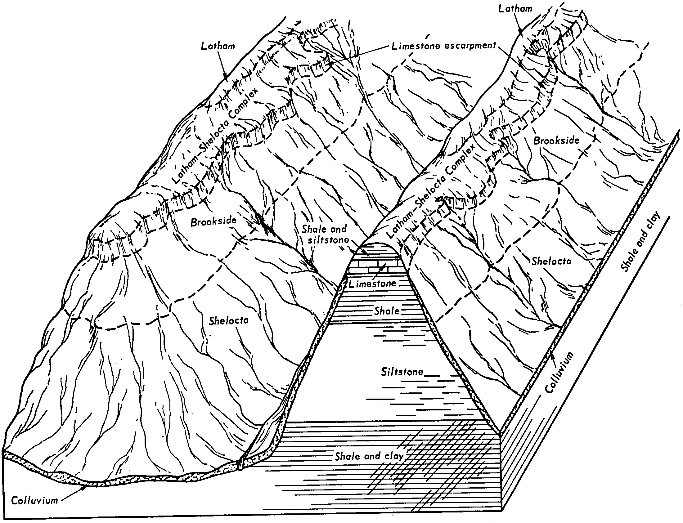
| Brookside silty clay loam, 35 to 60 percent slopes, bouldery | 690G | 1059 | 200507 | 6qmz | il157 | 2001 | 1:12000 |
Brookside silty clay loam, 18 to 35 percent slopes, stony | 690F | 1042 | 200506 | 6qmy | il157 | 2001 | 1:12000 |
Brookside-Rock outcrop complex, 30 to 75 percent slopes | BrF | 6025 | 552383 | ljst | ky199 | 1969 | 1:12000 |
Brookside-Faywood-Rock outcrop complex, 30 to 65 percent slopes | BxF | 12018 | 552253 | ljnm | ky628 | 1973 | 1:20000 |
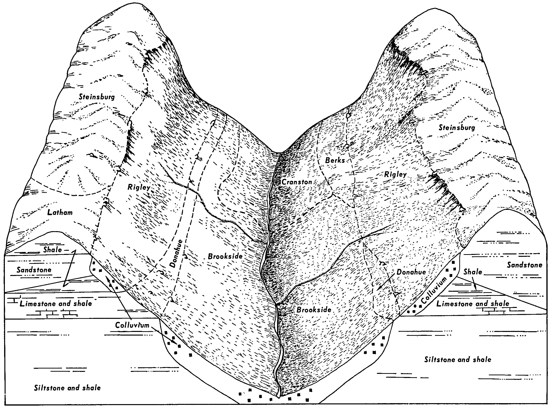
Vandalia-Brookside complex, 15 to 25 percent slopes | VbD | 15400 | 537395 | l16b | oh009 | 1981 | 1:15840 |
Brookside silt loam, 15 to 25 percent slopes | BrD | 6980 | 537344 | 2t31v | oh009 | 1981 | 1:15840 |
Elba-Brookside-Berks complex, 40 to 70 percent slopes | EbF | 4480 | 537355 | l151 | oh009 | 1981 | 1:15840 |
Vandalia-Brookside complex, 25 to 40 percent slopes | VbE | 3630 | 537396 | l16c | oh009 | 1981 | 1:15840 |
Brookside silt loam, 25 to 40 percent slopes | BrE | 1300 | 537345 | l14q | oh009 | 1981 | 1:15840 |
Brookside silt loam, 8 to 15 percent slopes | BrC | 430 | 537343 | 2t31w | oh009 | 1981 | 1:15840 |
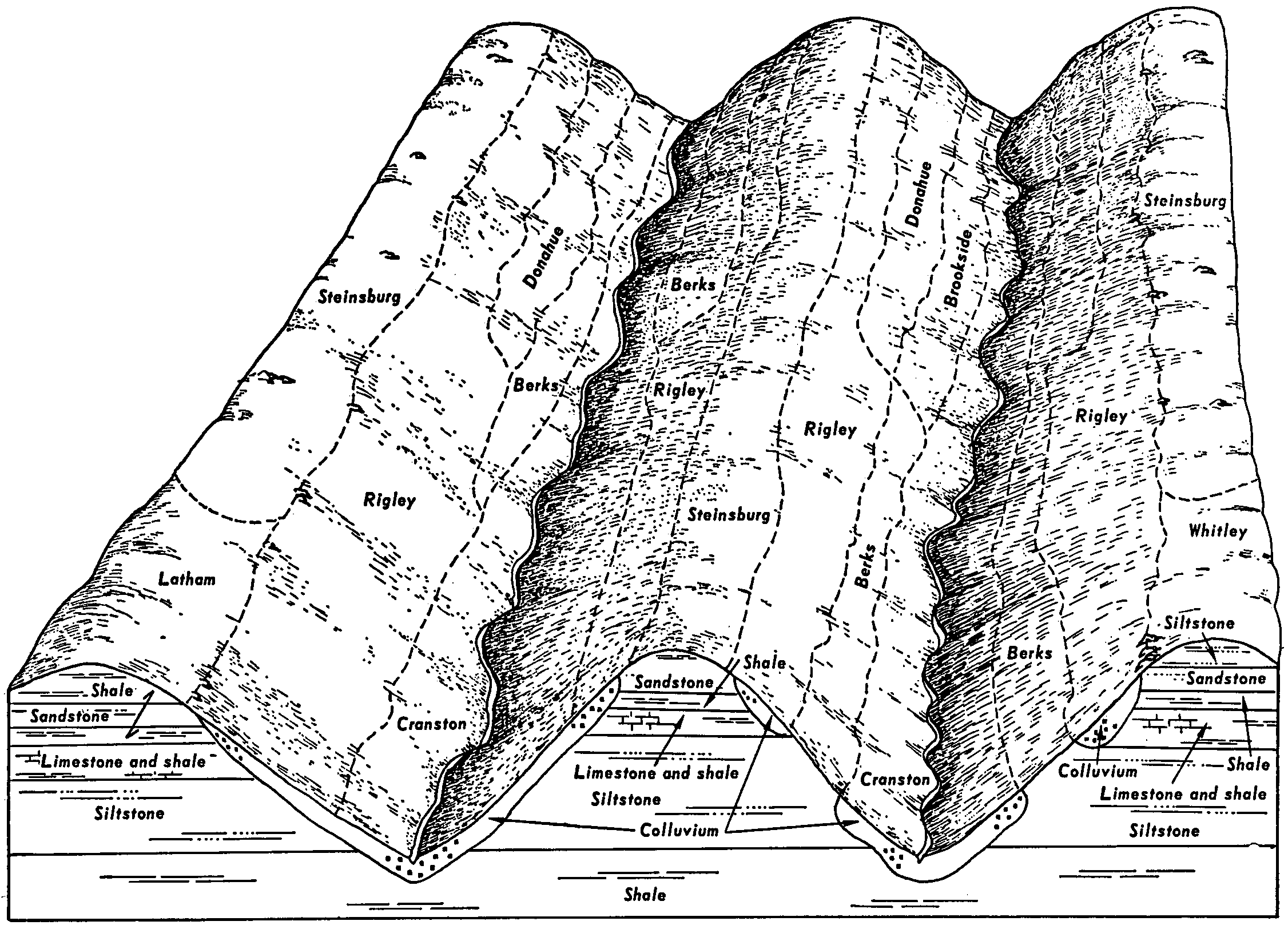
Brookside silty clay loam, 15 to 25 percent slopes | BsD | 3725 | 537063 | 2t31r | oh013 | 1978 | 1:15840 |
Brookside silty clay loam, 25 to 40 percent slopes | BsE | 2724 | 537064 | 2t31t | oh013 | 1978 | 1:15840 |
Brookside silty clay loam, 8 to 15 percent slopes | BsC | 783 | 537062 | 2t31s | oh013 | 1978 | 1:15840 |
Brookside-Urban land complex, 15 to 40 percent slopes | BuD | 647 | 537066 | l0vq | oh013 | 1978 | 1:15840 |
Brookside-Urban land complex, 3 to 15 percent slopes | BuB | 576 | 537065 | l0vp | oh013 | 1978 | 1:15840 |
Brookside-Vandalia complex, 15 to 25 percent slopes | BtD | 4313 | 536879 | l0np | oh059 | 1998 | 1:15840 |
Brookside-Vandalia complex, 25 to 40 percent slopes | BtE | 543 | 536880 | l0nq | oh059 | 1998 | 1:15840 |
Brookside silt loam, 15 to 25 percent slopes, eroded | BsD2 | 358 | 1592919 | 1qgkh | oh059 | 1998 | 1:15840 |
Brookside silt loam, 15 to 25 percent slopes | BsD | 340 | 536877 | 2t31v | oh059 | 1998 | 1:15840 |
Brookside-Vandalia complex, 8 to 15 percent slopes | BtC | 189 | 536878 | l0nn | oh059 | 1998 | 1:15840 |
Brookside silty clay loam, 8 to 15 percent slopes, eroded | BrC2 | 111 | 1592905 | 1qgk1 | oh059 | 1998 | 1:15840 |
Brookside silty clay loam, 15 to 25 percent slopes | BkD | 37 | 1592915 | 2t31r | oh059 | 1998 | 1:15840 |
Brookside silty clay loam, 25 to 40 percent slopes | BkE | 32 | 1592916 | 2t31t | oh059 | 1998 | 1:15840 |
Brookside silty clay loam, 15 to 40 percent slopes | BrE | 8 | 1592906 | 1qgk2 | oh059 | 1998 | 1:15840 |
Brookside-Vandalia complex, 15 to 25 percent slopes, eroded | BtD2 | 2 | 1592920 | 1qgkj | oh059 | 1998 | 1:15840 |
Brookside silty clay loam, 15 to 25 percent slopes | BsD | 68 | 536722 | 2t31r | oh067 | 1993 | 1:15840 |
Brookside silty clay loam, 25 to 40 percent slopes | BsE | 15 | 1695497 | 2t31t | oh067 | 1993 | 1:15840 |
Brookside silty clay loam, 25 to 40 percent slopes | BsE | 2924 | 536063 | 2t31t | oh081 | 1987 | 1:15840 |
Brookside silty clay loam, 15 to 25 percent slopes | BsD | 1444 | 536062 | 2t31r | oh081 | 1987 | 1:15840 |
Brookside silty clay loam, 8 to 15 percent slopes | BsC | 244 | 536061 | 2t31s | oh081 | 1987 | 1:15840 |
Vandalia-Brookside complex, 15 to 25 percent slopes | VbD | 10 | 1527420 | 1n8dm | oh105 | 1991 | 1:15840 |
Brookside silt loam, 15 to 25 percent slopes, eroded | BsD2 | 52 | 1469243 | 1l9vy | oh111 | 1968 | 1:15840 |
Brookside silty clay loam, 15 to 25 percent slopes | BtD | 26 | 1469268 | 2t31r | oh111 | 1968 | 1:15840 |
Brookside silty clay loam, 20 to 35 percent slopes | BrE | 2975 | 537425 | l179 | oh115 | 1992 | 1:15840 |
Brookside silty clay loam, 12 to 20 percent slopes | BrD | 1534 | 537424 | l178 | oh115 | 1992 | 1:15840 |
Vandalia-Brookside complex, 12 to 20 percent slopes, eroded | VbD2 | 344 | 537469 | l18q | oh115 | 1992 | 1:15840 |
Brookside silty clay loam, 15 to 40 percent slopes | BtE | 250 | 1541130 | 1nqnw | oh115 | 1992 | 1:15840 |
Brookside silty clay loam, 15 to 40 percent slopes | BsE | 1270 | 537863 | l1pf | oh119 | 1989 | 1:15840 |
Brookside silty clay loam, 8 to 15 percent slopes, eroded | BsC2 | 843 | 537862 | l1pd | oh119 | 1989 | 1:15840 |
Brookside silt loam, 15 to 25 percent slopes, eroded | BsD2 | 3600 | 536985 | l0s3 | oh121 | 1986 | 1:15840 |
Brookside-Vandalia complex, 25 to 35 percent slopes, eroded | BtE2 | 1300 | 536987 | l0s5 | oh121 | 1986 | 1:15840 |
Brookside-Vandalia complex, 15 to 25 percent slopes, eroded | BtD2 | 1100 | 536986 | l0s4 | oh121 | 1986 | 1:15840 |
Brookside-Vandalia complex, 15 to 25 percent slopes | BtD | 711 | 1481800 | 1lqy0 | oh121 | 1986 | 1:15840 |
Brookside silt loam, 8 to 15 percent slopes, eroded | BsC2 | 350 | 536984 | l0s2 | oh121 | 1986 | 1:15840 |
Brookside-Vandalia complex, 8 to 15 percent slopes | BtC | 203 | 1481799 | 1lqxz | oh121 | 1986 | 1:15840 |
Brookside-Vandalia complex, 25 to 40 percent slopes | BtE | 115 | 1481801 | 1lqy1 | oh121 | 1986 | 1:15840 |
Brookside silt loam, 15 to 25 percent slopes | BrD | 93 | 1481817 | 2t31v | oh121 | 1986 | 1:15840 |
Brookside silt loam, 8 to 15 percent slopes | BrC | 15 | 1481816 | 2t31w | oh121 | 1986 | 1:15840 |
Brookside silt loam, 25 to 40 percent slopes | BrE | 5 | 1481818 | 1lqyl | oh121 | 1986 | 1:15840 |
Brookside silty clay loam, 18 to 25 percent slopes | BsE | 1708 | 536458 | l073 | oh167 | 1973 | 1:15840 |
Brookside silty clay loam, 12 to 18 percent slopes | BsD | 960 | 536457 | l072 | oh167 | 1973 | 1:15840 |
Brookside silty clay loam, 6 to 12 percent slopes | BsC | 542 | 536456 | l071 | oh167 | 1973 | 1:15840 |
Brookside bouldery silty clay loam, 18 to 35 percent slopes | BtF | 538 | 536459 | l074 | oh167 | 1973 | 1:15840 |
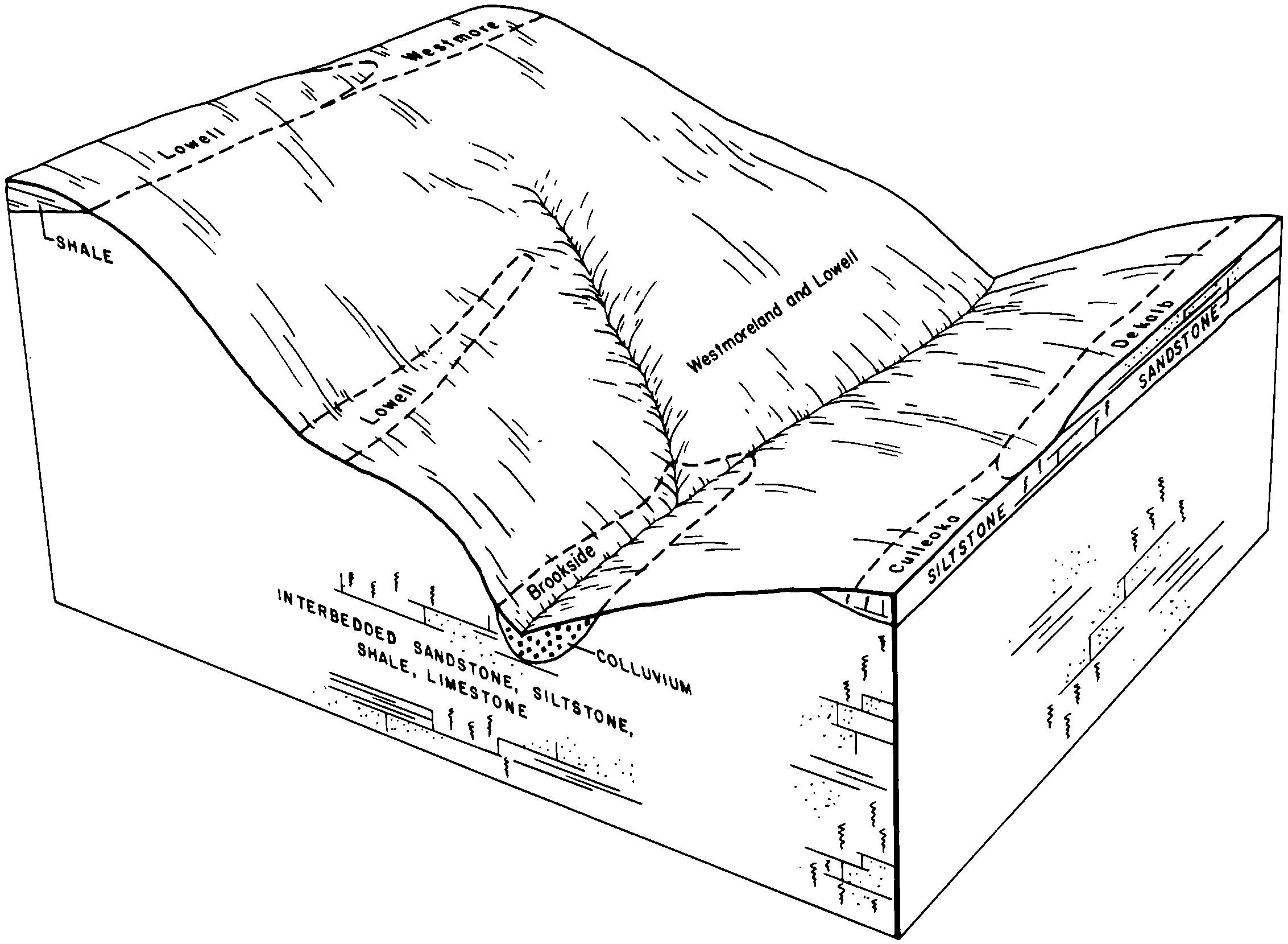
Brookside silt loam, 15 to 25 percent slopes | BrD | 2451 | 1602313 | 2t31v | wv051 | 2007 | 1:12000 |
Brookside silt loam, 25 to 35 percent slopes | BrE | 2402 | 1602312 | 1qsbh | wv051 | 2007 | 1:12000 |
Brookside silt loam, 8 to 15 percent slopes | BrC | 432 | 1602314 | 2t31w | wv051 | 2007 | 1:12000 |
Urban land-Brookside complex, 15 to 25 percent slopes | UmD | 267 | 1608846 | 1r048 | wv051 | 2007 | 1:12000 |
Urban land-Brookside complex, 3 to 15 percent slopes | UmC | 104 | 1608844 | 1r046 | wv051 | 2007 | 1:12000 |
Brookside silt loam, 3 to 8 percent slopes | BrB | 77 | 1862608 | 20j64 | wv051 | 2007 | 1:12000 |
Brookside silt loam, 15 to 25 percent slopes | BrD | 1191 | 1602545 | 2t31v | wv604 | 1970 | 1:20000 |