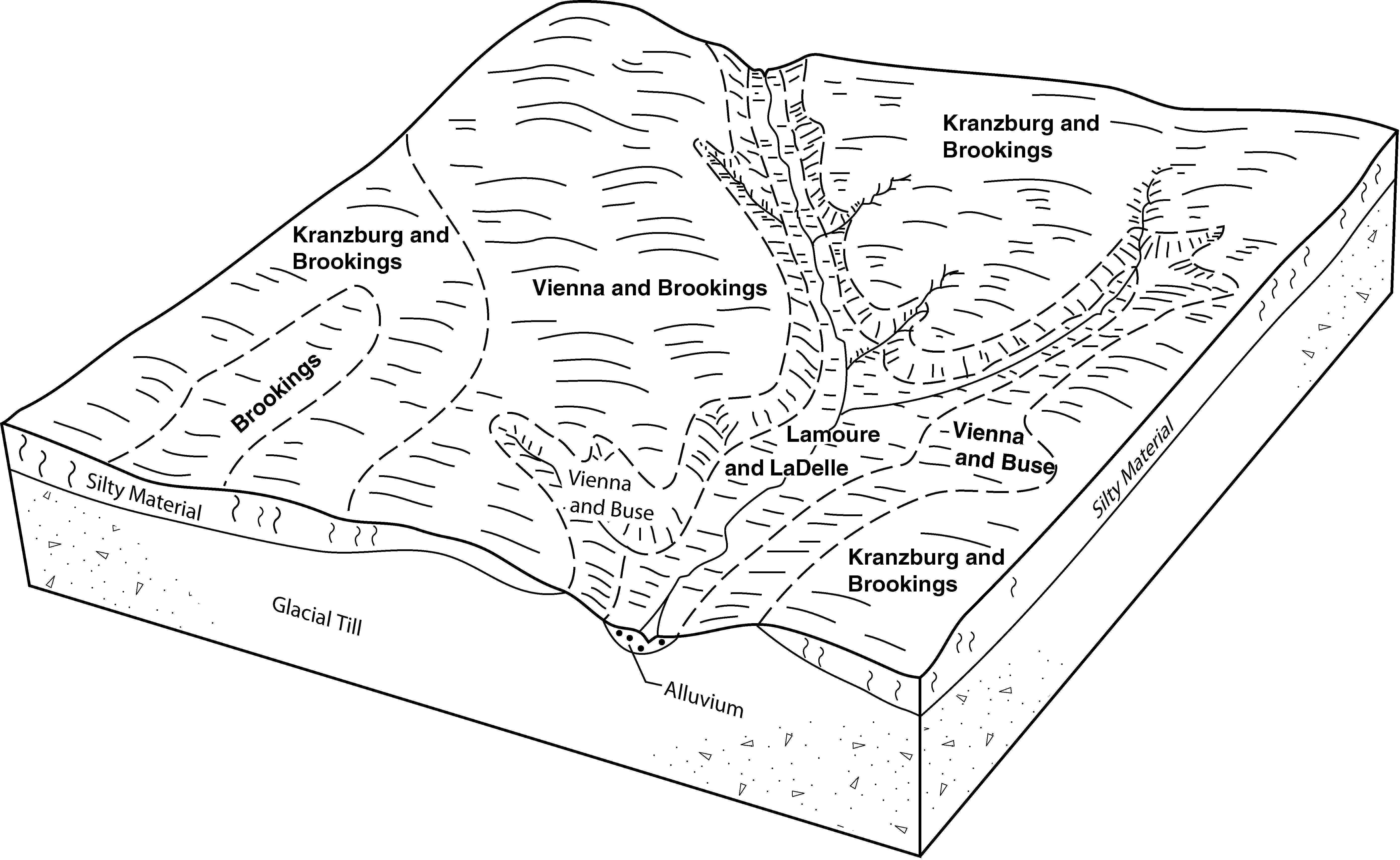
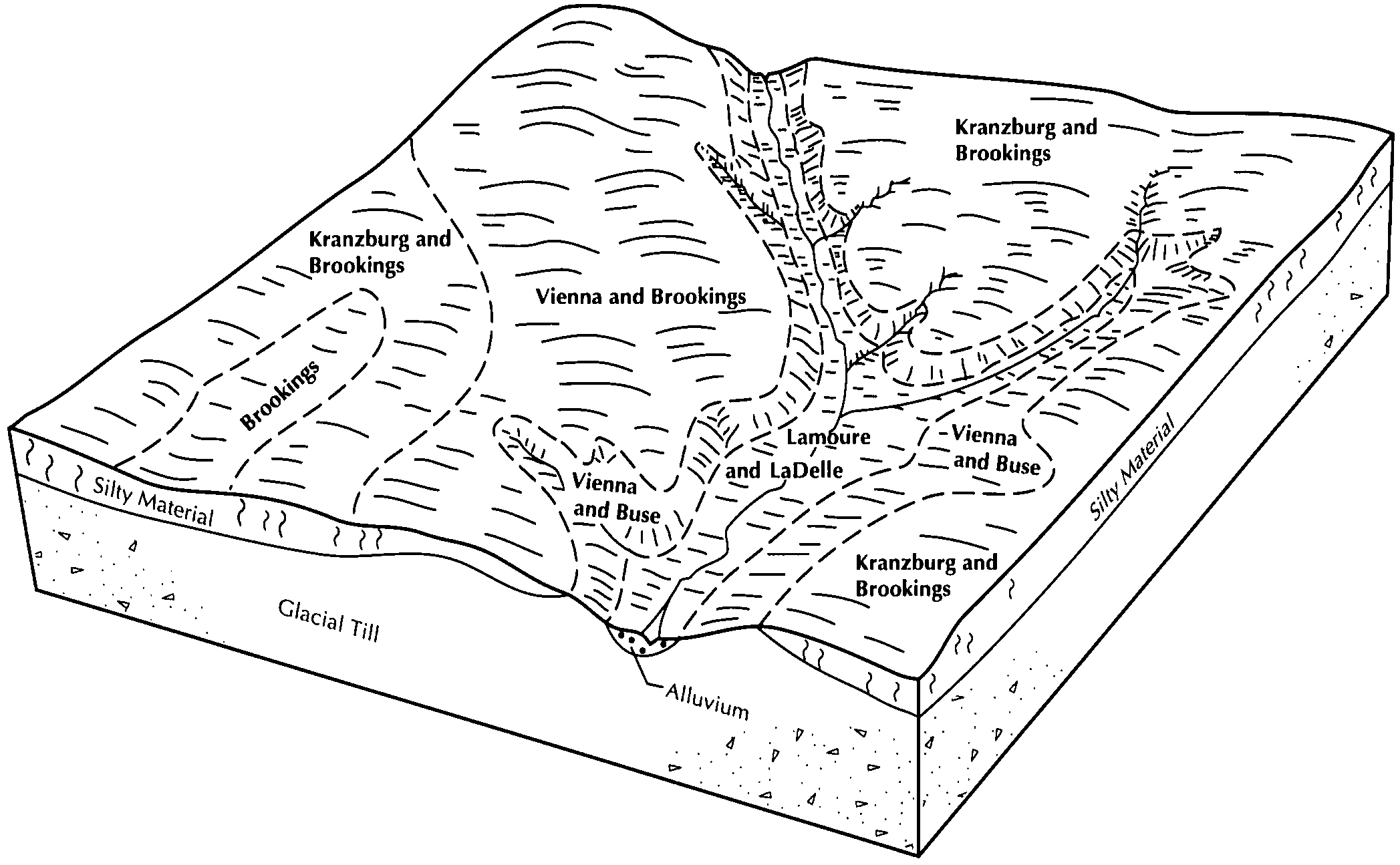
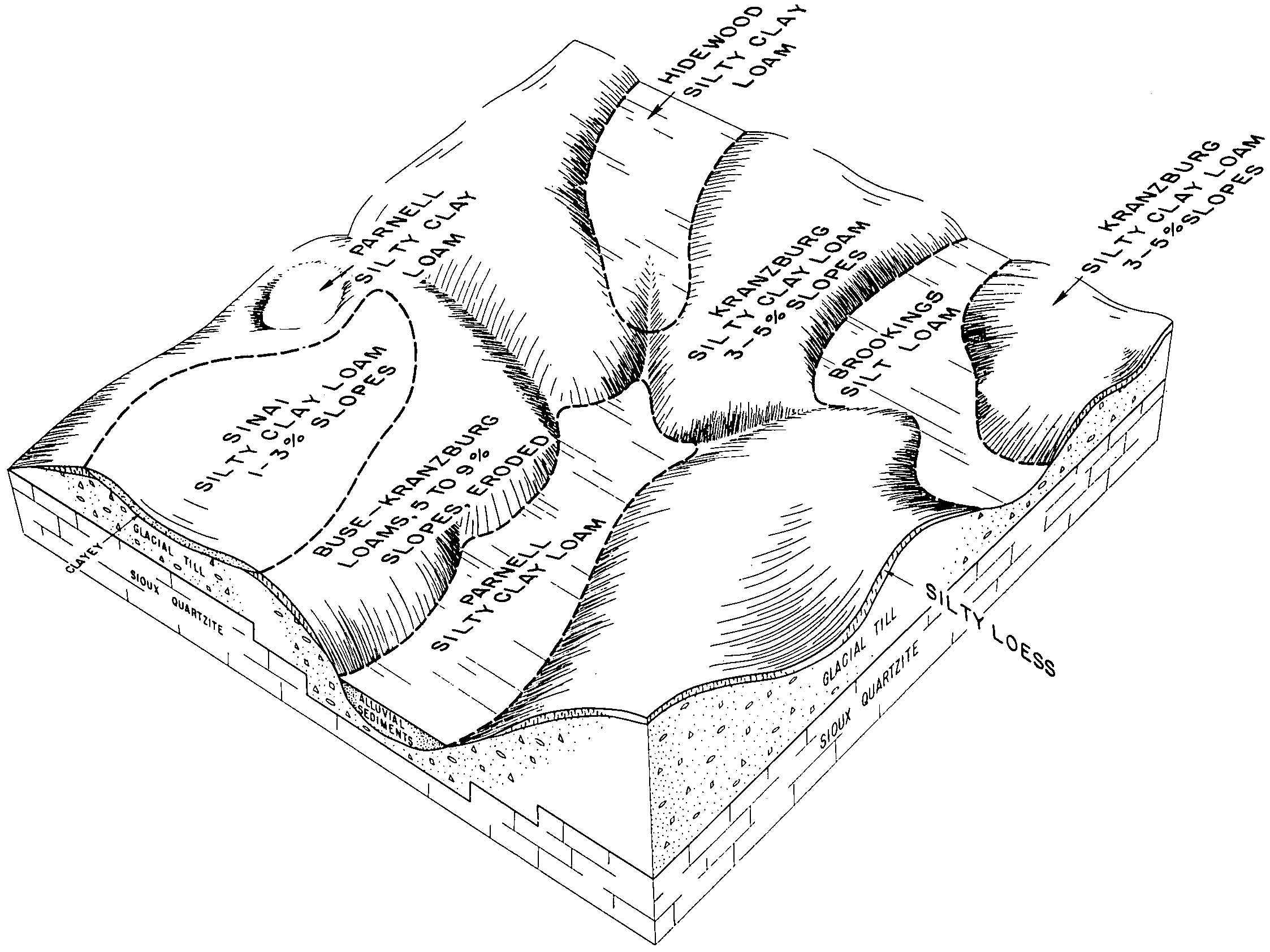
| Kranzburg-Brookings silty clay loams, 1 to 6 percent slopes | J90B | 17916 | 991439 | 2wkp4 | mn081 | 2007 | 1:12000 |
Brookings silty clay loam, 0 to 2 percent slopes | J71A | 6895 | 991432 | 2wkp5 | mn081 | 2007 | 1:12000 |
Vienna-Brookings complex, 1 to 6 percent slopes | J79B | 1186 | 991442 | 2wkpx | mn081 | 2007 | 1:12000 |
Vienna-Brookings complex, 1 to 6 percent slopes | J79B | 3978 | 988905 | 2wkpx | mn101 | 2008 | 1:12000 |
Kranzburg-Brookings silty clay loams, 1 to 6 percent slopes | J90B | 1 | 1947682 | 2wkp4 | mn101 | 2008 | 1:12000 |
Kranzburg-Brookings silty clay loams, 1 to 6 percent slopes | J90B | 54508 | 780322 | 2wkp4 | mn117 | 2005 | 1:12000 |
Brookings silty clay loam, 0 to 2 percent slopes | J71A | 46211 | 780265 | 2wkp5 | mn117 | 2005 | 1:12000 |
Vienna-Brookings complex, 1 to 6 percent slopes | J79B | 3789 | 780668 | 2wkpx | mn117 | 2005 | 1:12000 |
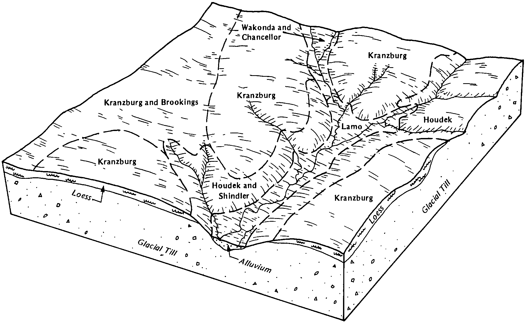
Kranzburg-Brookings silty clay loams, 1 to 6 percent slopes | KrB | 29703 | 418768 | 2wkp4 | sd011 | 1995 | 1:24000 |
Kranzburg-Brookings silty clay loams, 0 to 2 percent slopes | KrA | 20378 | 418767 | 2wkp2 | sd011 | 1995 | 1:24000 |
Vienna-Brookings complex, 1 to 6 percent slopes | VbB | 12908 | 418818 | 2wkpx | sd011 | 1995 | 1:24000 |
Vienna-Brookings complex, 0 to 2 percent slopes | VbA | 9686 | 418817 | 2wkpw | sd011 | 1995 | 1:24000 |
Brookings silty clay loam, 0 to 2 percent slopes | Bf | 3556 | 418724 | 2wkp5 | sd011 | 1995 | 1:24000 |
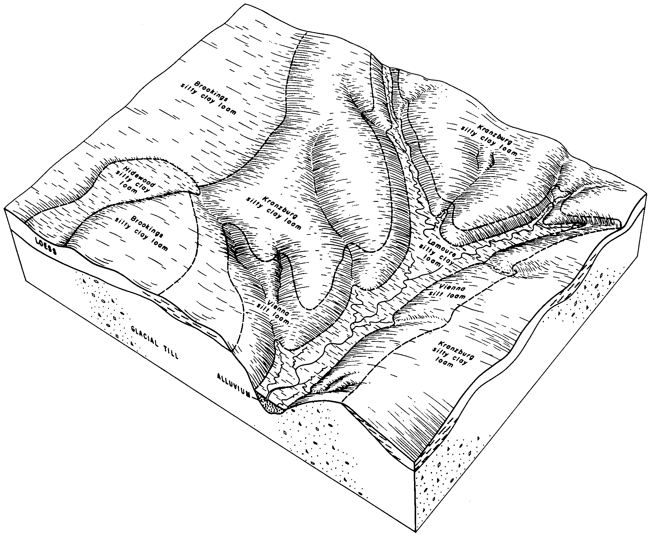
Kranzburg-Brookings silt loams, 0 to 2 percent slopes | G790A | 8681 | 2797820 | 2sd5q | sd013 | 1987 | 1:20000 |
Kranzburg-Brookings-Buse complex, 0 to 6 percent slopes | G792B | 2721 | 2797822 | 2sd5x | sd013 | 1987 | 1:20000 |
Kranzburg-Brookings silt loams, 2 to 6 percent slopes | G790B | 404 | 2797821 | 2sd5r | sd013 | 1987 | 1:20000 |
Vienna-Brookings complex, 1 to 6 percent slopes | Z192B | 28105 | 2765246 | 2wkpx | sd029 | 2006 | 1:12000 |
Vienna-Brookings complex, 0 to 2 percent slopes | Z192A | 19321 | 2765245 | 2wkpw | sd029 | 2006 | 1:12000 |
Kranzburg-Brookings silty clay loams, 0 to 2 percent slopes | J143A | 16463 | 1684436 | 2wkp2 | sd029 | 2006 | 1:12000 |
Kranzburg-Brookings silty clay loams, 1 to 6 percent slopes | J143B | 8233 | 1684438 | 2wkp4 | sd029 | 2006 | 1:12000 |
Brookings silty clay loam, 0 to 2 percent slopes | Z190A | 2374 | 2765244 | 2wkp5 | sd029 | 2006 | 1:12000 |
Kranzburg-Brookings silt loams, 0 to 2 percent slopes | G790A | 32151 | 2798526 | 2sd5q | sd037 | 1992 | 1:20000 |
Kranzburg-Brookings-Buse complex, 0 to 6 percent slopes | G792B | 11853 | 2798528 | 2sd5x | sd037 | 1992 | 1:20000 |
Kranzburg-Brookings silt loams, 2 to 6 percent slopes | G790B | 3061 | 2798527 | 2sd5r | sd037 | 1992 | 1:20000 |
Vienna-Brookings complex, 1 to 6 percent slopes | VoB | 2082 | 417142 | 2wkpx | sd037 | 1992 | 1:20000 |
Vienna-Brookings complex, 0 to 2 percent slopes | VoA | 510 | 417141 | 2wkpw | sd037 | 1992 | 1:20000 |
Kranzburg-Brookings-Buse complex, 1 to 6 percent slopes | KrB | 56 | 417092 | g00l | sd037 | 1992 | 1:20000 |
Kranzburg-Brookings silt loams, 0 to 2 percent slopes | Ks | 37 | 417093 | g00m | sd037 | 1992 | 1:20000 |
Kranzburg-Brookings silty clay loams, 1 to 6 percent slopes | KrB | 34581 | 416867 | 2wkp4 | sd039 | 1992 | 1:20000 |
Vienna-Brookings complex, 1 to 6 percent slopes | VtB | 22547 | 416911 | 2wkpx | sd039 | 1992 | 1:20000 |
Kranzburg-Brookings silty clay loams, 0 to 2 percent slopes | KrA | 15185 | 416866 | 2wkp2 | sd039 | 1992 | 1:20000 |
Vienna-Brookings complex, 0 to 2 percent slopes | VrA | 7437 | 416910 | 2wkpw | sd039 | 1992 | 1:20000 |
Brookings silty clay loam, 0 to 2 percent slopes | Br | 1571 | 416839 | 2wkp5 | sd039 | 1992 | 1:20000 |
Kranzburg-Brookings silty clay loams, 2 to 9 percent slopes | KrC | 1276 | 416868 | fzsc | sd039 | 1992 | 1:20000 |
Vienna-Brookings complex, 1 to 6 percent slopes | Z192B | 13515 | 2712902 | 2wkpx | sd051 | 1977 | 1:20000 |
Vienna-Brookings complex, 0 to 2 percent slopes | Z192A | 10027 | 2712901 | 2wkpw | sd051 | 1977 | 1:20000 |
Brookings silty clay loam, 0 to 2 percent slopes | Z190A | 602 | 2712900 | 2wkp5 | sd051 | 1977 | 1:20000 |
Vienna-Brookings complex, 1 to 6 percent slopes | VbB | 17531 | 417319 | 2wkpx | sd057 | 1992 | 1:20000 |
Kranzburg-Brookings silty clay loams, 1 to 6 percent slopes | KrB | 6115 | 417283 | 2wkp4 | sd057 | 1992 | 1:20000 |
Vienna-Brookings complex, 0 to 2 percent slopes | VbA | 5074 | 417318 | 2wkpw | sd057 | 1992 | 1:20000 |
Kranzburg-Brookings silty clay loams, 0 to 2 percent slopes | KrA | 1941 | 417282 | 2wkp2 | sd057 | 1992 | 1:20000 |
Brookings silty clay loam, 0 to 2 percent slopes | Bs | 559 | 417255 | 2wkp5 | sd057 | 1992 | 1:20000 |
Vienna-Brookings complex, 1 to 6 percent slopes | VbB | 2204 | 417521 | 2wkpx | sd077 | 1992 | 1:20000 |
Vienna-Brookings complex, 0 to 2 percent slopes | VbA | 834 | 417520 | 2wkpw | sd077 | 1992 | 1:20000 |
Kranzburg-Brookings silt loams, 0 to 2 percent slopes | G790A | 12841 | 2799374 | 2sd5q | sd091 | 1970 | 1:20000 |
Kranzburg-Brookings silt loams, 2 to 6 percent slopes | G790B | 8494 | 2799375 | 2sd5r | sd091 | 1970 | 1:20000 |
Kranzburg-Brookings-Buse complex, 0 to 6 percent slopes | G792B | 1525 | 2799380 | 2sd5x | sd091 | 1970 | 1:20000 |
Kranzburg-Brookings silty clay loams, 1 to 6 percent slopes | KaB | 18313 | 418340 | 2wkp4 | sd101 | 1985 | 1:20000 |
Kranzburg-Brookings silty clay loams, 0 to 2 percent slopes | KbA | 3020 | 418341 | 2wkp2 | sd101 | 1985 | 1:20000 |
Vienna-Brookings complex, 1 to 6 percent slopes | Z192B | 8683 | 2712797 | 2wkpx | sd109 | 1977 | 1:20000 |
Vienna-Brookings complex, 0 to 2 percent slopes | Z192A | 2978 | 2712796 | 2wkpw | sd109 | 1977 | 1:20000 |
Kranzburg-Brookings silt loams, 0 to 2 percent slopes | G790A | 6888 | 2800034 | 2sd5q | sd115 | 1997 | 1:24000 |
Kranzburg-Brookings-Buse complex, 0 to 6 percent slopes | G792B | 5557 | 2800036 | 2sd5x | sd115 | 1997 | 1:24000 |
Kranzburg-Brookings silt loams, 2 to 6 percent slopes | G790B | 314 | 2800035 | 2sd5r | sd115 | 1997 | 1:24000 |
