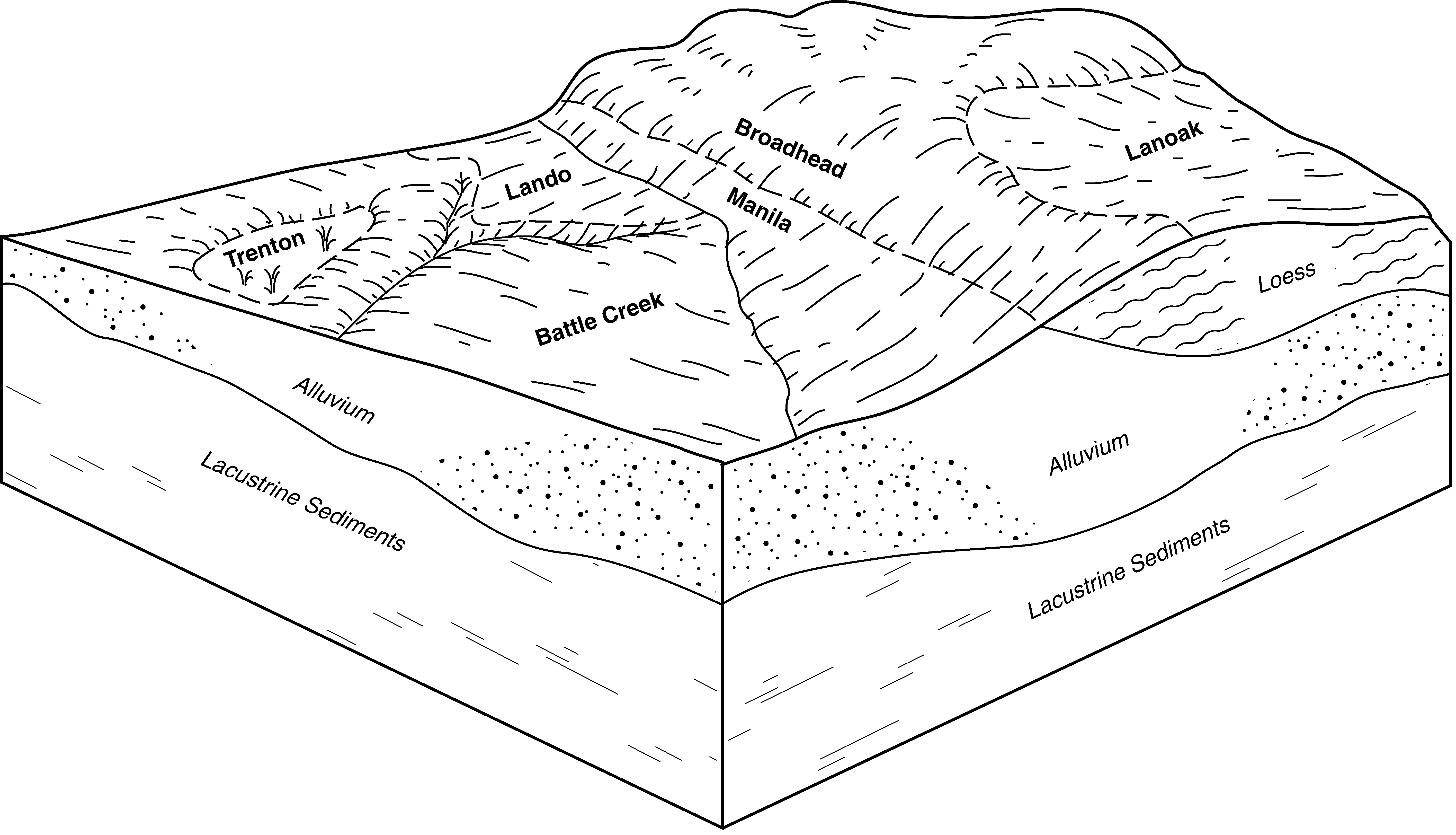
| Dranburn-Broadhead-Lanoak complex, 10 to 30 percent slopes | 470D | 17 | 3238958 | n466 | id710 | 1968 | 1:24000 |
Toponce-Broadhead association, 6 to 30 percent slopes | 112 | 2304 | 82865 | 2s72 | id711 | 1983 | 1:24000 |
Broadhead-Yago, extremely stony surface, complex, 4 to 12 percent slopes | 15 | 1900 | 3163520 | 2szw6 | id711 | 1983 | 1:24000 |
Broadhead-Yago complex, 12 to 20 percent slopes | 16 | 1563 | 82885 | 2s7q | id711 | 1983 | 1:24000 |
Broadhead-Hades-Yago complex, 4 to 20 percent slopes | 14 | 1426 | 82883 | 2s7n | id711 | 1983 | 1:24000 |
Broadhead-Faim-Farlow family, very stony surface, complex, 15 to 45 percent slopes | 461 | 156 | 3173249 | 2rg01 | id711 | 1983 | 1:24000 |
Drage-Vitale, stony surface-Broadhead association, 5 to 30 percent slopes | DGF | 9 | 3238965 | n4bk | id711 | 1983 | 1:24000 |
Broadhead silt loam, 4 to 12 percent slopes | 33 | 1299 | 154256 | 55j0 | id712 | 2008 | 1:24000 |
Broadhead-Hades-Swanpeak complex, 10 to 30 percent slopes | 34 | 808 | 154455 | 55qf | id712 | 2008 | 1:24000 |
Broadhead silt loam, 1 to 4 percent slopes | 32 | 427 | 154255 | 55hz | id712 | 2008 | 1:24000 |
Manila-Broadhead complex, 12 to 30 percent slopes, MLRA 47 | 7547 | 236 | 3173320 | 2x027 | id712 | 2008 | 1:24000 |
Broadhead-Faim-Farlow family, very stony surface, complex, 15 to 45 percent slopes | 461 | 6045 | 2619869 | 2rg01 | id713 | | 1:24000 |
Manila-Broadhead complex, 12 to 30 percent slopes, MLRA 13 | 75 | 2799 | 2619851 | 2v072 | id713 | | 1:24000 |
Manila-Broadhead complex, 12 to 30 percent slopes, MLRA 47 | 7547 | 1809 | 2980914 | 2x027 | id713 | | 1:24000 |
Broadhead-Hades-Yago, very stony surface, complex, 5 to 35 percent slopes | BHE | 1382 | 2917057 | n4b7 | id713 | | 1:24000 |
Manila-Broadhead complex, 4 to 12 percent slopes | 74 | 284 | 2619850 | 2v071 | id713 | | 1:24000 |
Dranburn-Broadhead-Lanoak complex, 10 to 30 percent slopes | 470D | 80 | 2520241 | n466 | id713 | | 1:24000 |
Broadhead-Yago, extremely stony surface, complex, 4 to 12 percent slopes | 15 | 40 | 2830433 | 2szw6 | id713 | | 1:24000 |
Lanoak-Broadhead-Hades complex, 25 to 50 percent slopes | 77-F | 26 | 3163230 | 2yy48 | id713 | | 1:24000 |
Manila-Broadhead complex, 12 to 30 percent slopes | 92 | 9303 | 485343 | j917 | id714 | 1997 | 1:24000 |
Manila-Broadhead complex, 4 to 12 percent slopes | 91 | 6365 | 485341 | j915 | id714 | 1997 | 1:24000 |
Lanoak-Broadhead complex, 12 to 30 percent slopes | 76 | 4015 | 485324 | j90m | id714 | 1997 | 1:24000 |
Lanoak-Broadhead-Hades complex, 25 to 50 percent slopes | 77 | 2360 | 3163571 | 2yy48 | id714 | 1997 | 1:24000 |
Toponce-Broadhead association, 6 to 30 percent slopes | 139 | 206 | 485230 | j8xl | id714 | 1997 | 1:24000 |
Broadhead-Hades-Yago, very stony surface, complex, 5 to 35 percent slopes | BHE | 82 | 3173331 | n4b7 | id714 | 1997 | 1:24000 |
Manila-Broadhead complex, 4 to 12 percent slopes | 74-O | 72 | 3173328 | 2v071 | id714 | 1997 | 1:24000 |
Broadhead-Hades-Yago complex, 4 to 20 percent slopes | 30 | 47 | 485274 | j8z0 | id714 | 1997 | 1:24000 |
Broadhead-Yago complex, 12 to 20 percent slopes | 31 | 25 | 485275 | j8z1 | id714 | 1997 | 1:24000 |
Broadhead-Faim-Farlow family, very stony surface, complex, 15 to 45 percent slopes | 461 | 3 | 3173344 | 2rg01 | id714 | 1997 | 1:24000 |
Manila-Broadhead complex, 12 to 30 percent slopes, MLRA 13 | 75 | 8095 | 3163598 | 2v072 | id715 | 1994 | 1:24000 |
Manila-Broadhead complex, 4 to 12 percent slopes | 74 | 7365 | 3163597 | 2v071 | id715 | 1994 | 1:24000 |
Broadhead-Faim-Farlow family, very stony surface, complex, 15 to 45 percent slopes | 461 | 808 | 3173373 | 2rg01 | id715 | 1994 | 1:24000 |
Dranburn-Broadhead-Lanoak complex, 10 to 30 percent slopes | 470D | 3418 | 599856 | n466 | id716 | | 1:24000 |
Broadhead-Hades-Yago, very stony surface, complex, 5 to 35 percent slopes | BHE | 1103 | 599981 | n4b7 | id716 | | 1:24000 |
Broadhead-Yago, very stony surface, complex, 12 to 35 percent slopes | BYE | 693 | 599987 | n4bf | id716 | | 1:24000 |
Drage-Vitale, stony surface-Broadhead association, 5 to 30 percent slopes | DGF | 594 | 599991 | n4bk | id716 | | 1:24000 |
Hades-Broadhead complex, 10 to 30 percent slopes | 6085 | 320 | 2989731 | 2x3mt | id716 | | 1:24000 |
Broadhead-Yago, very stony surface, complex, 4 to 12 percent slopes | BYD | 217 | 599986 | n4bd | id716 | | 1:24000 |
Broadhead loam, 3 to 25 percent slopes | BnD | 588 | 482470 | j61k | ut608 | 1981 | 1:24000 |
Broadhead loam, 25 to 70 percent slopes | BnF | 246 | 482471 | j61l | ut608 | 1981 | 1:24000 |
Broadhead clay loam, 2 to 5 percent slopes | BeB | 310 | 506511 | k022 | ut609 | 1974 | 1:24000 |
Broadhead-Little Pole association, steep | BPE | 12788 | 504191 | jxn7 | ut622 | 1967 | 1:24000 |
Broadhead-Little Pole association, very steep | BPF | 9192 | 504192 | jxn8 | ut622 | 1967 | 1:24000 |
Broadhead soils, 15 to 25 percent slopes | BTD | 3453 | 504194 | jxnb | ut622 | 1967 | 1:24000 |
Broadhead soils, 6 to 15 percent slopes | BTC | 3261 | 504193 | jxn9 | ut622 | 1967 | 1:24000 |
Horrocks-Broadhead association, very steep | HWF | 3209 | 504256 | jxqb | ut622 | 1967 | 1:24000 |
Horrocks-Broadhead association, steep | HWE | 2884 | 504255 | jxq9 | ut622 | 1967 | 1:24000 |
Broadhead soils, 25 to 40 percent slopes | BTE | 1916 | 504195 | jxnc | ut622 | 1967 | 1:24000 |
Broadhead-Little Pole association, hilly | BPD | 1710 | 504190 | jxn6 | ut622 | 1967 | 1:24000 |
Broadhead very cobbly loam, 15 to 40 percent slopes | BOE | 1640 | 504188 | jxn4 | ut622 | 1967 | 1:24000 |
Broadhead-Little Pole association, moderately steep | BPC | 648 | 504189 | jxn5 | ut622 | 1967 | 1:24000 |
Broadhead soils, 40 to 60 percent slopes | BTF | 448 | 504196 | jxnd | ut622 | 1967 | 1:24000 |
Horrocks-Broadhead association, moderately steep | HWC | 296 | 504254 | jxq8 | ut622 | 1967 | 1:24000 |


