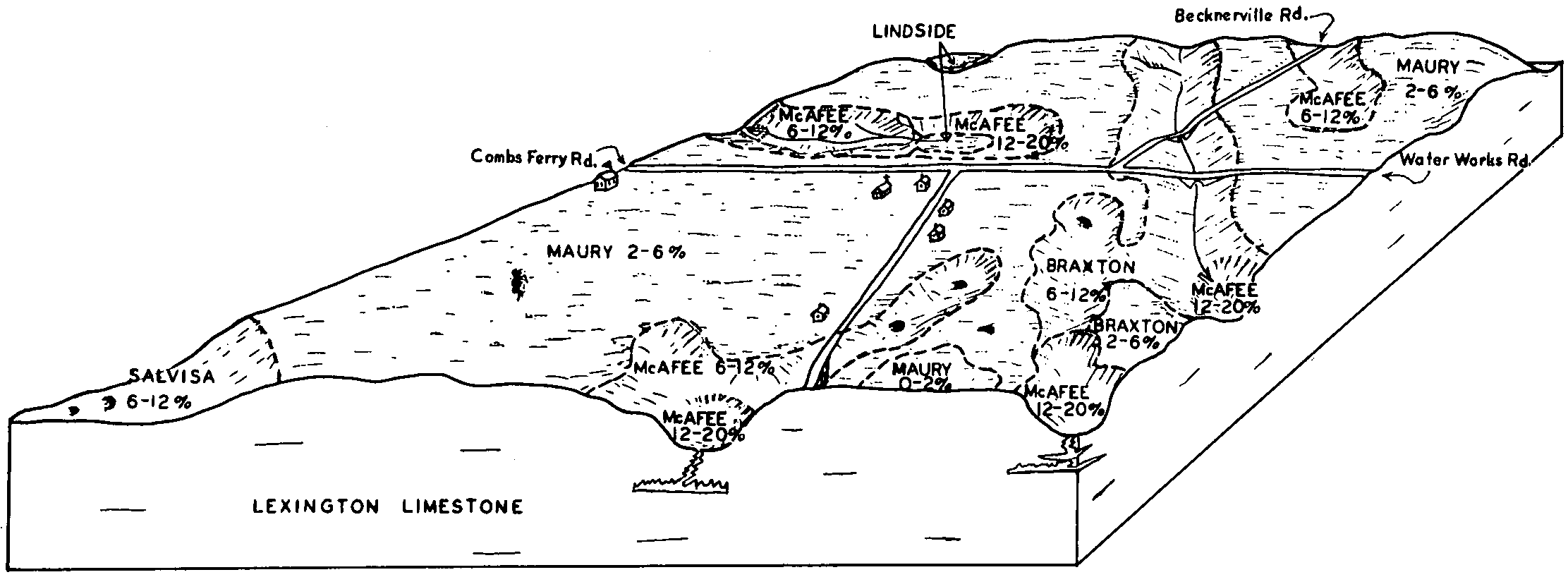
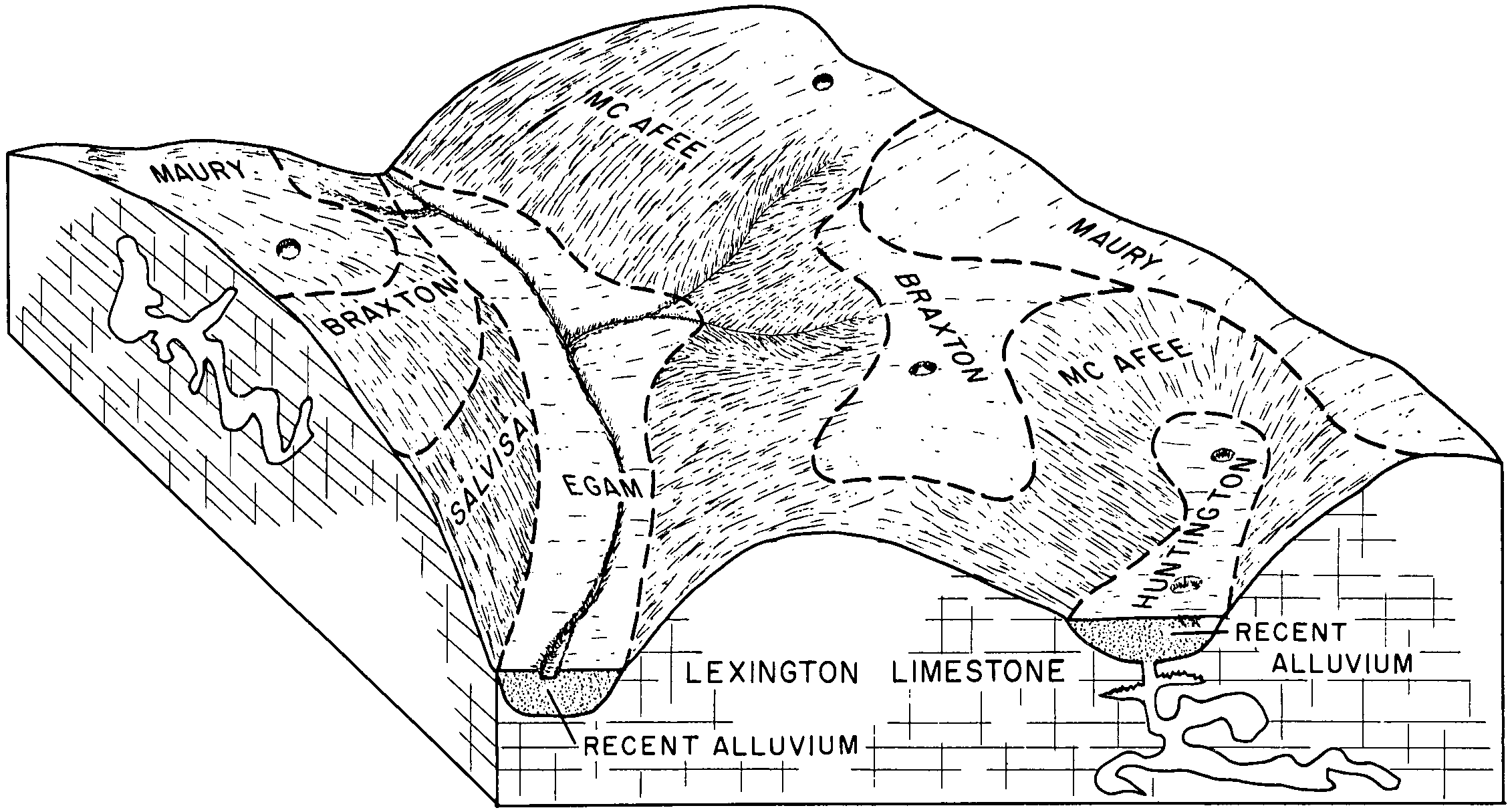
| Lyerly-Barfield-Braxton-Rock outcrop complex, 2 to 25 percent slopes | LrD | 10402 | 531501 | kv26 | ga619 | 2012 | 1:24000 |
Braxton-Talbott-Lyerly complex, 2 to 6 percent slopes, very rocky | BtB | 2984 | 2567646 | 2q79g | ga619 | 2012 | 1:24000 |
Braxton-Talbott-Lyerly complex, 6 to 10 percent slopes, very rocky | BtC | 2966 | 2567647 | 2q79h | ga619 | 2012 | 1:24000 |
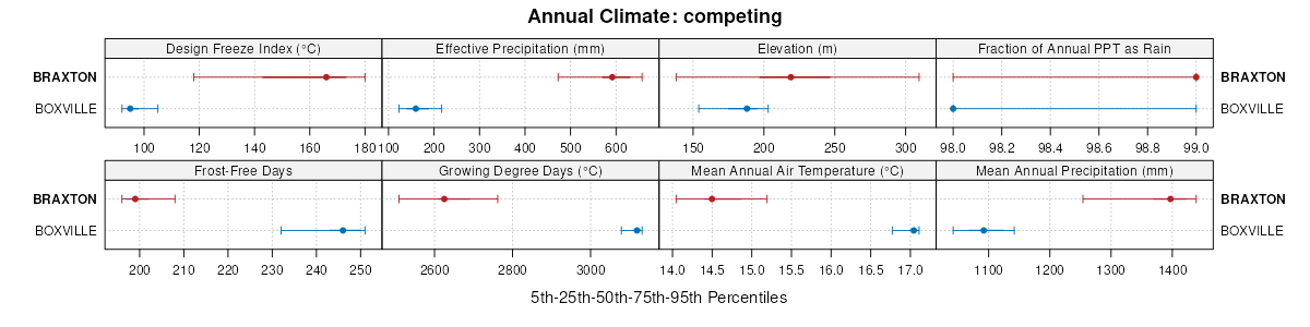
Braxton silt loam, 2 to 5 percent slopes, eroded | BrB2 | 4434 | 529363 | krv7 | tn003 | 1998 | 1:24000 |
Braxton silt loam, 5 to 12 percent slopes, eroded | BrC2 | 3457 | 529364 | krv8 | tn003 | 1998 | 1:24000 |
Braxton silty clay loam, 12 to 20 percent slopes, severely eroded | BxD3 | 775 | 529365 | krv9 | tn003 | 1998 | 1:24000 |
Talbott-Braxton-Rock outcrop complex, 20 to 35 percent slopes | TrE | 8732 | 526691 | kp21 | tn007 | 1987 | 1:24000 |
Talbott-Braxton-Rock outcrop complex, 6 to 20 percent slopes | TrD | 3739 | 526690 | kp20 | tn007 | 1987 | 1:24000 |
Talbott-Braxton complex, 6 to 12 percent slopes | TaC | 922 | 526688 | kp1y | tn007 | 1987 | 1:24000 |
Talbott-Braxton complex, 12 to 20 percent slopes | TaD | 830 | 526689 | kp1z | tn007 | 1987 | 1:24000 |
Talbott-Braxton complex, 2 to 6 percent slopes | TaB | 276 | 526687 | kp1x | tn007 | 1987 | 1:24000 |
Braxton silt loam, 5 to 12 percent slopes | BrC | 5875 | 526420 | kns9 | tn019 | 2000 | 1:24000 |
Braxton silt loam, 12 to 20 percent slopes, eroded | BrD2 | 5819 | 526421 | knsb | tn019 | 2000 | 1:24000 |
Braxton-Talbott-Rock outcrop complex, 20 to 35 percent slopes, eroded | BtE2 | 4823 | 526426 | knsh | tn019 | 2000 | 1:24000 |
Braxton silt loam, 20 to 35 percent slopes, eroded | BrE2 | 3420 | 526422 | knsc | tn019 | 2000 | 1:24000 |
Braxton-Talbott-Rock outcrop complex, 12 to 20 percent slopes, eroded | BtD2 | 2428 | 526425 | knsg | tn019 | 2000 | 1:24000 |
Braxton-Urban land complex, 5 to 20 percent slopes | BuD | 2163 | 526427 | knsj | tn019 | 2000 | 1:24000 |
Braxton silt loam, 2 to 5 percent slopes | BrB | 1985 | 557556 | lq5p | tn019 | 2000 | 1:24000 |
Braxton silt loam, 35 to 50 percent slopes, eroded | BrF2 | 1422 | 526423 | knsd | tn019 | 2000 | 1:24000 |
Talbott-Rock outcrop-Braxton complex, 20 to 40 percent slopes | ToE | 3413 | 523901 | kl51 | tn035 | 1998 | 1:24000 |
Talbott-Braxton-Rock outcrop complex, 5 to 20 percent slopes | TbD | 925 | 523900 | kl50 | tn035 | 1998 | 1:24000 |
Braxton silty clay loam, 5 to 12 percent slopes, severely eroded | BtC3 | 4240 | 527284 | kpp5 | tn055 | 1965 | 1:15840 |
Braxton cherty silt loam, 5 to 12 percent slopes, eroded | BrC2 | 3163 | 527280 | kpp1 | tn055 | 1965 | 1:15840 |
Braxton cherty silty clay loam, 5 to 12 percent slopes, severely eroded | BsC3 | 2445 | 527282 | kpp3 | tn055 | 1965 | 1:15840 |
Braxton cherty silty clay loam, 12 to 20 percent slopes, severely eroded | BsD3 | 2281 | 527283 | kpp4 | tn055 | 1965 | 1:15840 |
Braxton cherty silt loam, 12 to 20 percent slopes, eroded | BrD2 | 1995 | 527281 | kpp2 | tn055 | 1965 | 1:15840 |
Braxton cherty silt loam, 2 to 5 percent slopes, eroded | BrB2 | 887 | 527279 | kpp0 | tn055 | 1965 | 1:15840 |
Braxton silty clay loam, 12 to 20 percent slopes, severely eroded | BtD3 | 832 | 527285 | kpp6 | tn055 | 1965 | 1:15840 |
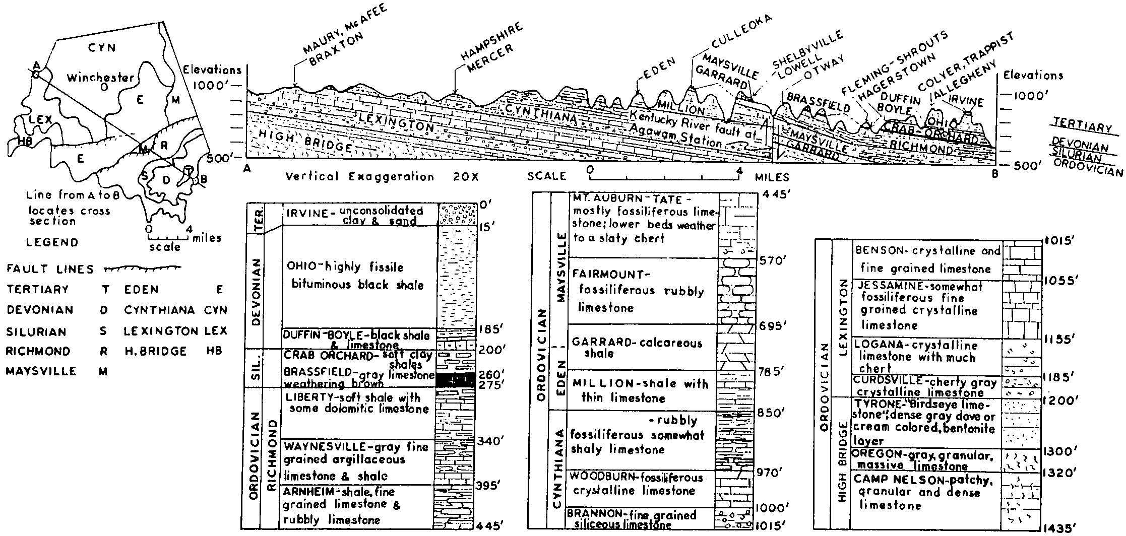
Talbott cherty silt loam, 12 to 25 percent slopes (Braxton) | TbE | 1388 | 327652 | bzyf | tn071 | 1961 | 1:15840 |
Talbott silt loam, 12 to 25 percent slopes (Braxton) | TsE | 1049 | 327659 | bzyn | tn071 | 1961 | 1:15840 |
Talbott cherty silt loam, 5 to 12 percent slopes (Braxton) | TbD | 1046 | 327651 | bzyd | tn071 | 1961 | 1:15840 |
Talbott silt loam, 5 to 8 percent slopes (Braxton) | TsC | 649 | 327657 | bzyl | tn071 | 1961 | 1:15840 |
Talbott silt loam, 8 to 12 percent slopes (Braxton) | TsD | 625 | 327658 | bzym | tn071 | 1961 | 1:15840 |
Talbott cherty silt loam, 25 to 35 percent slopes (Braxton) | TbF | 488 | 327653 | bzyg | tn071 | 1961 | 1:15840 |
Talbott silty clay, 8 to 25 percent slopes, severely eroded (Braxton) | TtE3 | 439 | 327661 | bzyq | tn071 | 1961 | 1:15840 |
Talbott cherty silty clay, 12 to 25 percent slopes, severely eroded (Braxton cr-sicl) | TcE3 | 335 | 327655 | bzyj | tn071 | 1961 | 1:15840 |
Talbott silty clay, 5 to 8 percent slopes, severely eroded (Braxton) | TtC3 | 258 | 327660 | bzyp | tn071 | 1961 | 1:15840 |
Talbott cherty silty clay, 5 to 12 percent slopes, severely eroded (Braxton) | TcD3 | 253 | 327654 | bzyh | tn071 | 1961 | 1:15840 |
Talbott silt loam, 2 to 5 percent slopes (Braxton) | TsB | 66 | 327656 | bzyk | tn071 | 1961 | 1:15840 |
Braxton silt loam, 2 to 5 percent slopes, eroded | BtB2 | 9608 | 524061 | klb6 | tn117 | 1999 | 1:24000 |
Braxton-Talbott-Rock outcrop complex, 2 to 12 percent slopes, eroded | BxC2 | 9497 | 524063 | klb8 | tn117 | 1999 | 1:24000 |
Braxton silt loam, 5 to 12 percent slopes, eroded | BtC2 | 2548 | 524062 | klb7 | tn117 | 1999 | 1:24000 |
Braxton cherty silty clay loam, severely eroded sloping phase | Bg | 13136 | 527741 | kq4x | tn119 | 1955 | 1:20000 |
Braxton silty clay loam, eroded sloping phase | Bk | 6718 | 527743 | kq4z | tn119 | 1955 | 1:20000 |
Braxton cherty silty clay, severely eroded moderately steep phase | Bf | 3818 | 527740 | kq4w | tn119 | 1955 | 1:20000 |
Braxton silt loam, eroded gently sloping phase | Bh | 3212 | 527742 | kq4y | tn119 | 1955 | 1:20000 |
Braxton silty clay loam, eroded moderately steep phase | Bl | 1780 | 527744 | kq50 | tn119 | 1955 | 1:20000 |
Braxton-Talbott complex, 15 to 35 percent slopes | BtE | 1542 | 560607 | ltc3 | tn135 | 2000 | 1:24000 |
Braxton-Talbott complex, 15 to 35 percent slopes, severely eroded | BtE3 | 1085 | 560608 | ltc4 | tn135 | 2000 | 1:24000 |
Braxton-Talbott complex, 5 to 15 percent slopes | BtC | 590 | 560605 | ltc1 | tn135 | 2000 | 1:24000 |
Braxton-Talbott complex, 5 to 15 percent slopes, severely eroded | BtC3 | 461 | 560606 | ltc2 | tn135 | 2000 | 1:24000 |
Colbert-Talbott-Braxton complex, 5 to 12 percent slopes, eroded | CtC2 | 586 | 529606 | ks32 | tn153 | 1995 | 1:24000 |
Colbert-Talbott-Braxton complex, 12 to 20 percent slopes, eroded | CtD2 | 490 | 529607 | ks33 | tn153 | 1995 | 1:24000 |
Braxton gravelly silt loam, 12 to 20 percent slopes, eroded | BxD2 | 498 | 529811 | ks9p | tn159 | 1992 | 1:24000 |
Braxton gravelly silt loam, 5 to 12 percent slopes, eroded | BxC2 | 279 | 529810 | ks9n | tn159 | 1992 | 1:24000 |
Braxton silt loam, 5 to 12 percent slopes | BrC | 504 | 1689624 | 1tq60 | tn179 | 1955 | 1:15840 |
Braxton-Urban land complex, 5 to 20 percent slopes | BuD | 351 | 1689629 | 1tq65 | tn179 | 1955 | 1:15840 |
Braxton-Talbott-Rock outcrop complex, 20 to 35 percent slopes, eroded | BtE2 | 183 | 1689628 | 1tq64 | tn179 | 1955 | 1:15840 |
Braxton silt loam, 12 to 20 percent slopes, eroded | BrD2 | 108 | 1689625 | 1tq61 | tn179 | 1955 | 1:15840 |
Braxton-Talbott-Rock outcrop complex, 12 to 20 percent slopes, eroded | BtD2 | 106 | 1689627 | 1tq63 | tn179 | 1955 | 1:15840 |
Braxton silt loam, 20 to 35 percent slopes, eroded | BrE2 | 13 | 1689626 | 1tq62 | tn179 | 1955 | 1:15840 |
Braxton silt loam, 2 to 5 percent slopes | BrB | 5 | 1689623 | 1tq5z | tn179 | 1955 | 1:15840 |
Braxton-Talbott complex, 15 to 35 percent slopes | BsE | 7270 | 328005 | c09t | tn181 | 1996 | 1:24000 |
Braxton-Talbott complex, 15 to 35 percent slopes, stony | BtE | 2325 | 328006 | c09v | tn181 | 1996 | 1:24000 |
Braxton-Talbott complex, 5 to 15 percent slopes | BsC | 2305 | 328004 | c09s | tn181 | 1996 | 1:24000 |
Braxton silt loam, 5 to 12 percent slopes | BrC | 725 | 328000 | c09n | tn181 | 1996 | 1:24000 |
Braxton silty clay loam, 5 to 12 percent slopes, severely eroded | BrC3 | 435 | 328001 | c09p | tn181 | 1996 | 1:24000 |
Braxton silt loam, 12 to 20 percent slopes | BrD | 286 | 328002 | c09q | tn181 | 1996 | 1:24000 |
Braxton silty clay loam, 12 to 20 percent slopes, severely eroded | BrD3 | 262 | 328003 | c09r | tn181 | 1996 | 1:24000 |
Braxton-Talbott-Gullied land complex, 5 to 20 percent slopes | BxC | 250 | 328007 | c09w | tn181 | 1996 | 1:24000 |
Braxton silt loam, 2 to 5 percent slopes | BrB | 170 | 327999 | c09m | tn181 | 1996 | 1:24000 |
Braxton cherty silt loam, 5 to 12 percent slopes, eroded | BrC2 | 2467 | 523473 | kkq7 | tn187 | 1961 | 1:15840 |
Braxton cherty silt loam, 2 to 5 percent slopes, eroded | BrB2 | 841 | 523472 | kkq6 | tn187 | 1961 | 1:15840 |
Braxton cherty silt loam, 12 to 20 percent slopes, eroded | BrD2 | 714 | 523474 | kkq8 | tn187 | 1961 | 1:15840 |
Braxton cherty silty clay loam, 5 to 12 percent slopes, severely eroded | BsC3 | 614 | 523475 | kkq9 | tn187 | 1961 | 1:15840 |
Braxton cherty silty clay loam, 12 to 20 percent slopes, severely eroded | BsD3 | 336 | 523476 | kkqb | tn187 | 1961 | 1:15840 |