| Brackett loam, 5 to 20 percent slopes | 2 | 5652 | 383282 | dvty | ok069 | 1976 | 1:24000 |
Brackett loam, 8 to 12 percent slopes | BKE | 15573 | 391075 | 30ytz | tx027 | 1972 | 1:24000 |
Brackett gravelly clay loam, 12 to 20 percent slopes | BrE | 23852 | 390451 | 2yly2 | tx029 | 2000 | 1:24000 |
Brackett-Eckrant association, 20 to 60 percent slopes | BtE | 17047 | 390453 | 2yly3 | tx029 | 2000 | 1:24000 |
Brackett gravelly clay loam, 3 to 12 percent slopes | BrD | 10955 | 390450 | 2t2m5 | tx029 | 2000 | 1:24000 |
Brackett-Eckrant association, 8 to 40 percent slopes | BtF | 78526 | 362984 | 30yv4 | tx035 | 1977 | 1:24000 |
Brackett gravelly clay loam, 1 to 5 percent slopes | BtC | 1081 | 363037 | 2szps | tx035 | 1977 | 1:24000 |
Hext-Oplin-Brackett association, hilly | 20 | 12743 | 363594 | d6bv | tx059 | 1979 | 1:24000 |
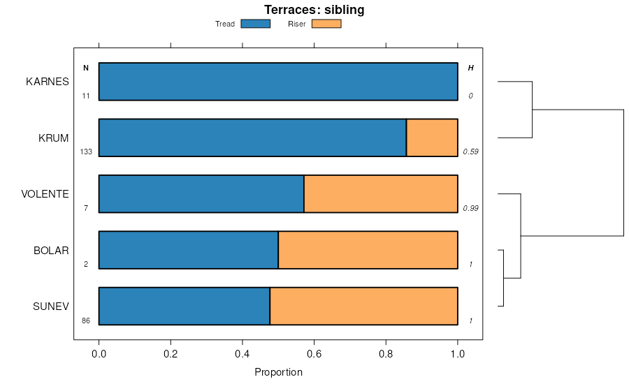
Brackett-Karnes complex, 1 to 12 percent slopes | BsE | 9536 | 364359 | d74j | tx093 | 1974 | 1:20000 |
Brackett-Bolar complex, 1 to 5 percent slopes | BrC | 6940 | 364358 | d74h | tx093 | 1974 | 1:20000 |
Brackett soils, 8 to 30 percent slopes | BTF | 3402 | 364349 | 2szpt | tx093 | 1974 | 1:20000 |
Brackett loam, 8 to 20 percent slopes | BtE | 1777 | 365227 | 30yv2 | tx133 | 1972 | 1:20000 |
Brackett stony loam, 1 to 8 percent slopes | BrD | 1751 | 365226 | d81h | tx133 | 1972 | 1:20000 |
Brackett-Purves complex | Bt | 25195 | 365356 | d85p | tx143 | 1966 | 1:20000 |
Brackett-Dugout complex, 8 to 40 percent slopes | BrF | 22742 | 365355 | d85n | tx143 | 1966 | 1:20000 |
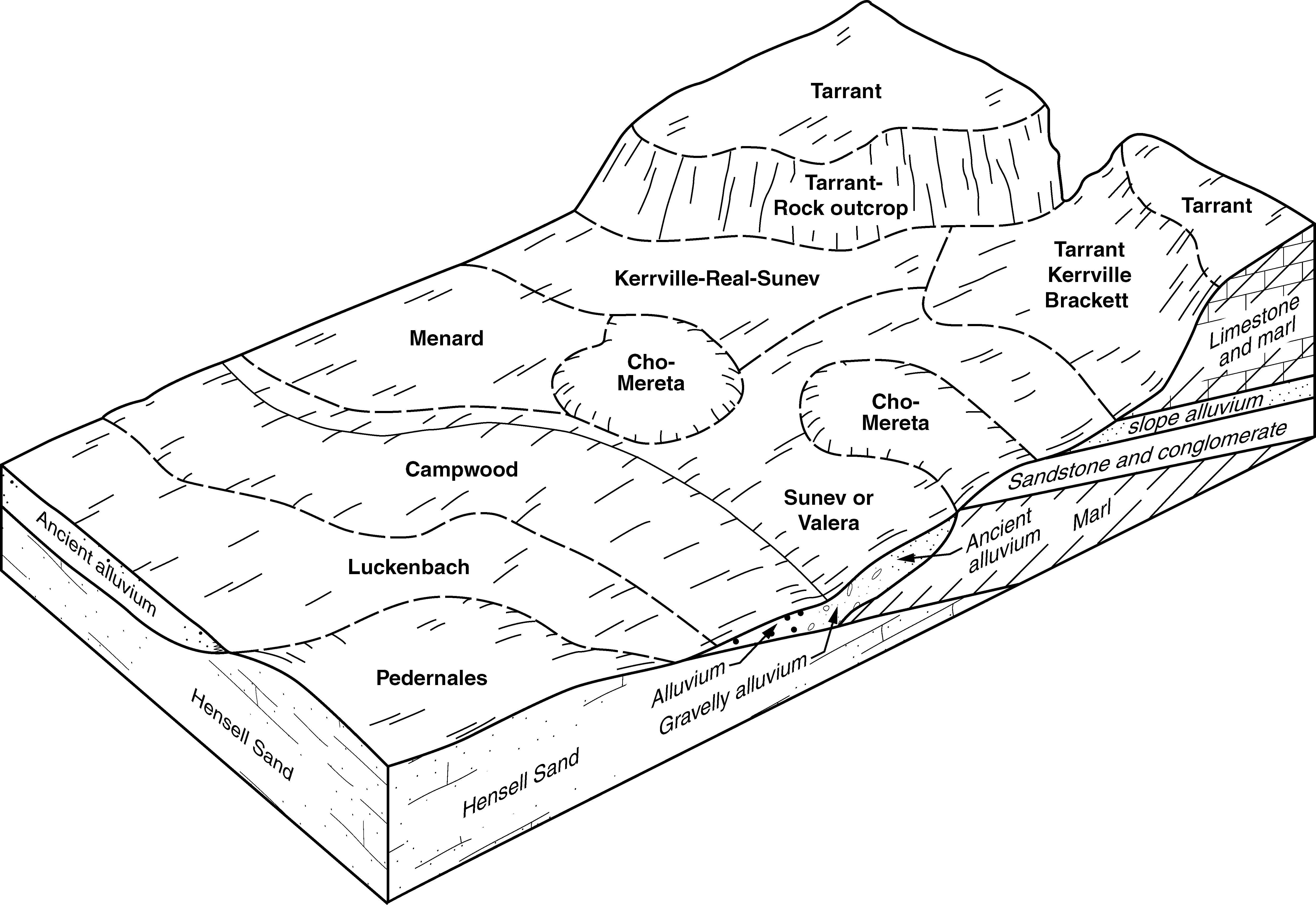
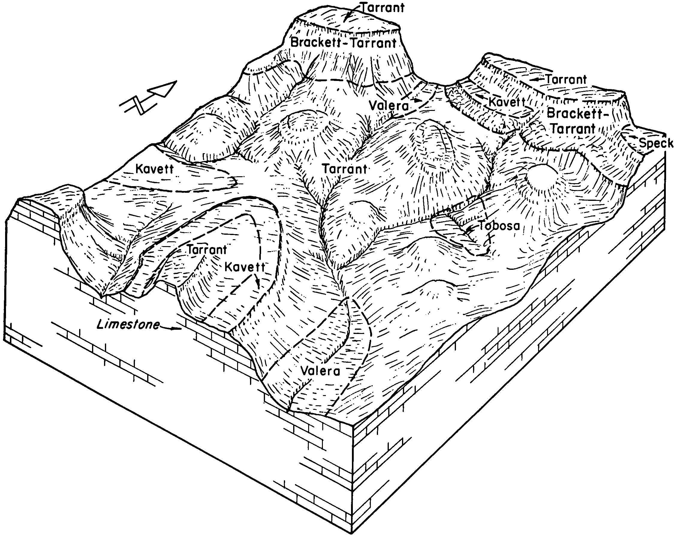
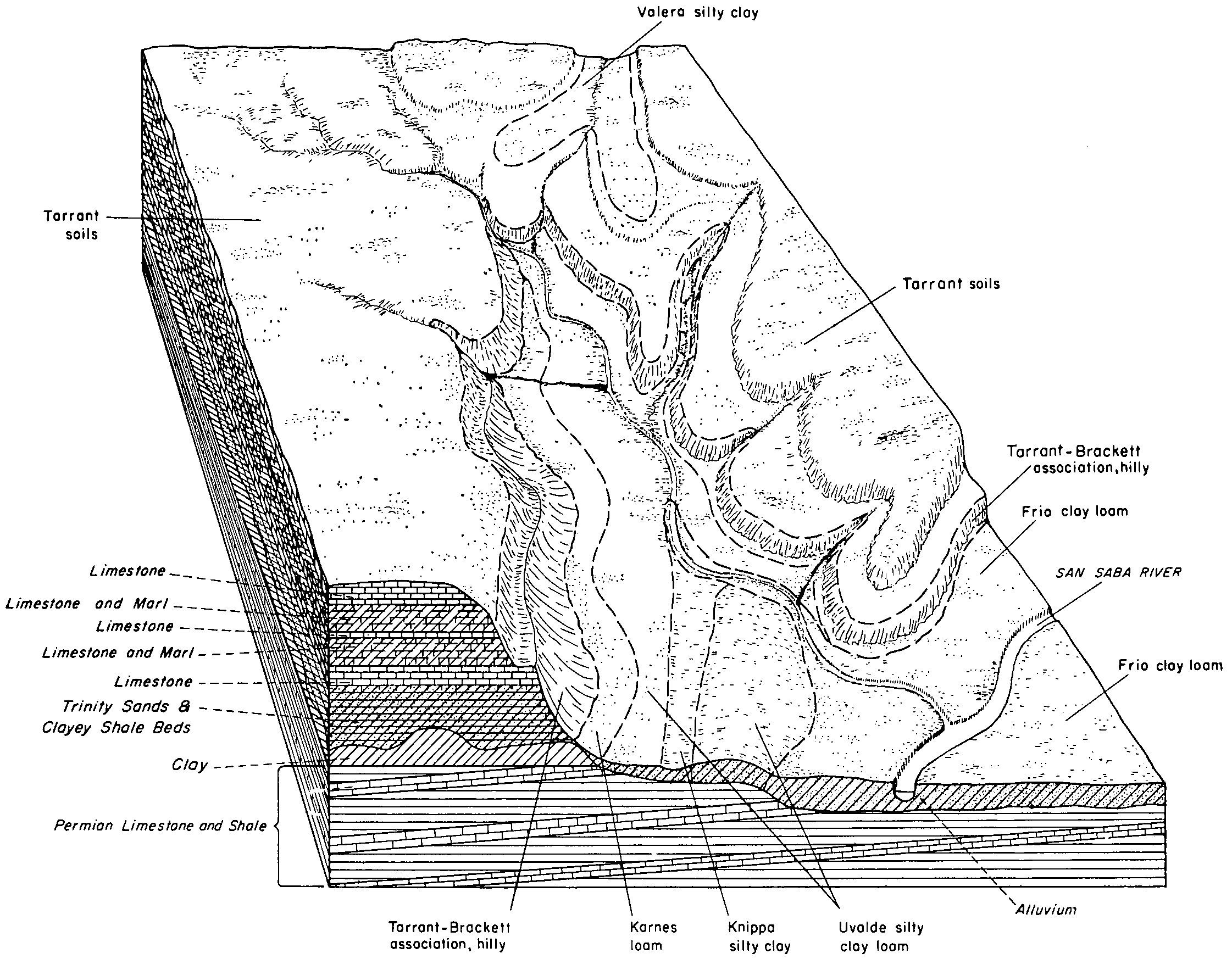
Brackett-Tarrant association, hilly | BtE | 22790 | 366175 | d913 | tx171 | 1970 | 1:20000 |
Brackett soils, hilly | BrE | 15333 | 366174 | d912 | tx171 | 1970 | 1:20000 |
Brackett soils, 1 to 8 percent slopes | BrC | 11447 | 366173 | 2t26g | tx171 | 1970 | 1:20000 |
Brackett-Pidcoke gravelly clay loams, 1 to 5 percent slopes | ByC | 21464 | 376651 | 30knd | tx193 | 1994 | 1:24000 |
Brackett-Maloterre complex, 2 to 12 percent slopes | BxD | 20613 | 376650 | 30knc | tx193 | 1994 | 1:24000 |
Brackett gravelly clay loam, 8 to 30 percent slopes | BtE | 11546 | 376649 | dmxz | tx193 | 1994 | 1:24000 |
Brackett gravelly clay loam, 1 to 5 percent slopes | BtC | 4037 | 376648 | 2szps | tx193 | 1994 | 1:24000 |
Brackett-Rock outcrop complex, 5 to 30 percent slopes | 20 | 5255 | 367732 | 30knj | tx217 | 1975 | 1:20000 |
Brackett-Rock outcrop complex, 5 to 30 percent slopes | BrE | 7056 | 368154 | 30knj | tx251 | 1981 | 1:20000 |
Brackett-Real association, 10 to 30 percent slopes | 5 | 89006 | 368463 | 2t271 | tx259 | 1979 | 1:31680 |
Doss-Brackett association, 1 to 8 percent slopes | 9 | 72975 | 368467 | 30gjs | tx259 | 1979 | 1:31680 |
Brackett association, 1 to 8 percent slopes | 4 | 24612 | 368462 | 2t26h | tx259 | 1979 | 1:31680 |
Real-Brackett complex, hilly | RbF | 28998 | 368559 | dcj0 | tx267 | 1980 | 1:31680 |
Brackett gravelly clay loam, 3 to 8 percent slopes | BrD | 152609 | 368849 | dctc | tx281 | 1990 | 1:24000 |
Brackett-Rock outcrop complex, 10 to 30 percent slopes | BrE | 26265 | 368850 | dctd | tx281 | 1990 | 1:24000 |
Brackett gravelly clay loam, 1 to 5 percent slopes | BrC | 1599 | 368848 | 30yv0 | tx281 | 1990 | 1:24000 |
Brackett-Tarrant association, steep | BUE | 10617 | 369931 | ddy8 | tx307 | 1970 | 1:24000 |
Brackett soils, 1 to 8 percent slopes | BtC | 6266 | 369936 | 2t26g | tx307 | 1970 | 1:24000 |
Brackett loam, 1 to 5 percent slopes | BsC | 4245 | 369935 | ddyd | tx307 | 1970 | 1:24000 |
Aledo-Brackett complex, 5 to 20 percent slopes | AdE | 5481 | 370071 | 30ytv | tx309 | 1992 | 1:24000 |
Kerrville, Brackett, and Tarrant soils, 12 to 40 percent slopes, very rocky | KTG | 10769 | 370410 | dffq | tx319 | 2011 | 1:24000 |
Tarrant-Brackett association, hilly | Tb | 22652 | 370615 | dfnb | tx327 | 1965 | 1:20000 |
Brackett soils, 1 to 8 percent slopes | BaC | 2853 | 370597 | 2t26g | tx327 | 1965 | 1:20000 |
Brackett-Maloterre complex, 2 to 12 percent slopes | BsE | 26369 | 390867 | 30knc | tx367 | 1973 | 1:20000 |
Brackett-Maloterre soils, 12 to 30 percent slopes | BsG | 4388 | 390868 | 30ytx | tx367 | 1973 | 1:20000 |
Brackett-Urban land complex, 3 to 12 percent slopes | BrE | 451 | 390866 | f3ql | tx367 | 1973 | 1:20000 |
Maloterre, Aledo, and Brackett soils, 3 to 20 percent slopes | MaC | 8395 | 372393 | 30knr | tx439 | 1979 | 1:20000 |
Brackett clay loam, 3 to 8 percent slopes | BrD | 1433 | 372361 | 30yv1 | tx439 | 1979 | 1:20000 |
Brackett-Rock outcrop complex, 1 to 12 percent slopes | BlD | 110018 | 392167 | 2yltz | tx453 | 1969 | 1:20000 |
Brackett-Rock outcrop-Real complex, 8 to 30 percent slopes | BoF | 57011 | 392168 | 2t2m3 | tx453 | 1969 | 1:20000 |
Brackett soils and Urban land, 12 to 30 percent slopes | BrF | 3207 | 392169 | 2ylty | tx453 | 1969 | 1:20000 |
Urban land and Brackett soils, 1 to 12 percent slopes | UuE | 2662 | 393256 | f66p | tx453 | 1969 | 1:20000 |
Brackett gravelly clay loam, 3 to 12 percent slopes | BkE | 15873 | 373525 | 2t2m5 | tx491 | 1981 | 1:20000 |
Brackett association, 1 to 8 percent slopes | BktD | 4262 | 373524 | 2t26h | tx491 | 1981 | 1:20000 |
Brackett-Rock outcrop-Real complex, 8 to 30 percent slopes | BkrG | 1760 | 373526 | 2t2m3 | tx491 | 1981 | 1:20000 |
Brackett-Aledo complex, 5 to 20 percent slopes | ByE | 18009 | 373654 | 30yv3 | tx497 | 1984 | 1:20000 |
Brackett association, 1 to 8 percent slopes | 6 | 170145 | 373942 | 2t26h | tx601 | 1977 | 1:31680 |
Brackett-Real association, 10 to 30 percent slopes | 7 | 157214 | 373943 | 2t271 | tx601 | 1977 | 1:31680 |
Bolar-Brackett complex, 1 to 8 percent slopes | 6 | 89912 | 391037 | f3x3 | tx602 | 1975 | 1:24000 |
Brackett-Tarrant complex, 8 to 30 percent slopes | 14 | 5135 | 390987 | 30knp | tx602 | 1975 | 1:24000 |
Hext-Brackett complex, 1 to 8 percent slopes | 37 | 4659 | 391012 | f3w9 | tx602 | 1975 | 1:24000 |
Brackett gravelly clay loam, 1 to 8 percent slopes | 13 | 4430 | 390986 | 30yty | tx602 | 1975 | 1:24000 |
Brackett-Rock outcrop-Comfort complex, 1 to 8 percent slopes | BtD | 110380 | 378708 | 2ylv1 | tx604 | 1981 | 1:20000 |
Brackett-Rock outcrop-Real complex, 8 to 30 percent slopes | BtG | 104633 | 378709 | 2t2m3 | tx604 | 1981 | 1:20000 |
Brackett soils, 8 to 30 percent slopes | BtF | 11738 | 374323 | 2szpt | tx609 | 1975 | 1:20000 |


