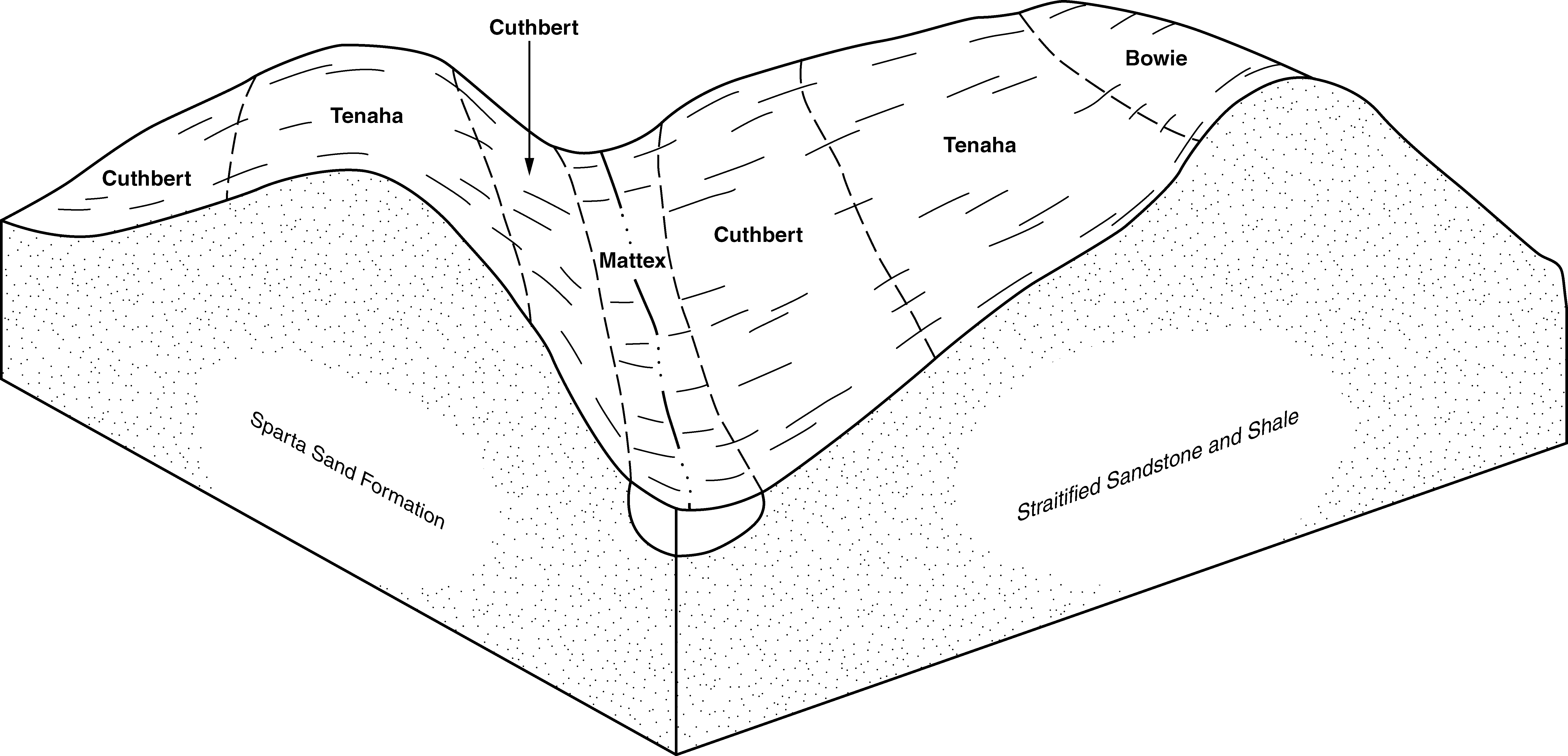
| Bowie, Lakeland, and Cuthbert soils, 8 to 12 percent slopes | BwD | 48421 | 328110 | c0f6 | al003 | 1961 | 1:20000 |
Bowie, Lakeland, and Cuthbert soils, 12 to 25 percent slopes, eroded | BwF2 | 23876 | 328112 | c0f8 | al003 | 1961 | 1:20000 |
Cuthbert, Bowie, and Sunsweet soils, 8 to 12 percent | CuD | 18577 | 328127 | c0fr | al003 | 1961 | 1:20000 |
Cuthbert, Bowie, and Sunsweet soils, 12 to 17 percent slopes, eroded | CuE2 | 12472 | 328128 | c0fs | al003 | 1961 | 1:20000 |
Bowie, Lakeland, and Cuthbert soils, 5 to 8 percent slopes | BwC | 7277 | 328109 | c0f5 | al003 | 1961 | 1:20000 |
Bowie fine sandy loam, thin solum, 2 to 5 percent slopes | BtB | 5016 | 328107 | c0f3 | al003 | 1961 | 1:20000 |
Bowie, Lakeland, and Cuthbert soils, 8 to 12 percent slopes, eroded | BwD2 | 3554 | 328111 | c0f7 | al003 | 1961 | 1:20000 |
Cuthbert, Bowie, and Sunsweet soils, 5 to 8 percent slopes | CuC | 873 | 328126 | c0fq | al003 | 1961 | 1:20000 |
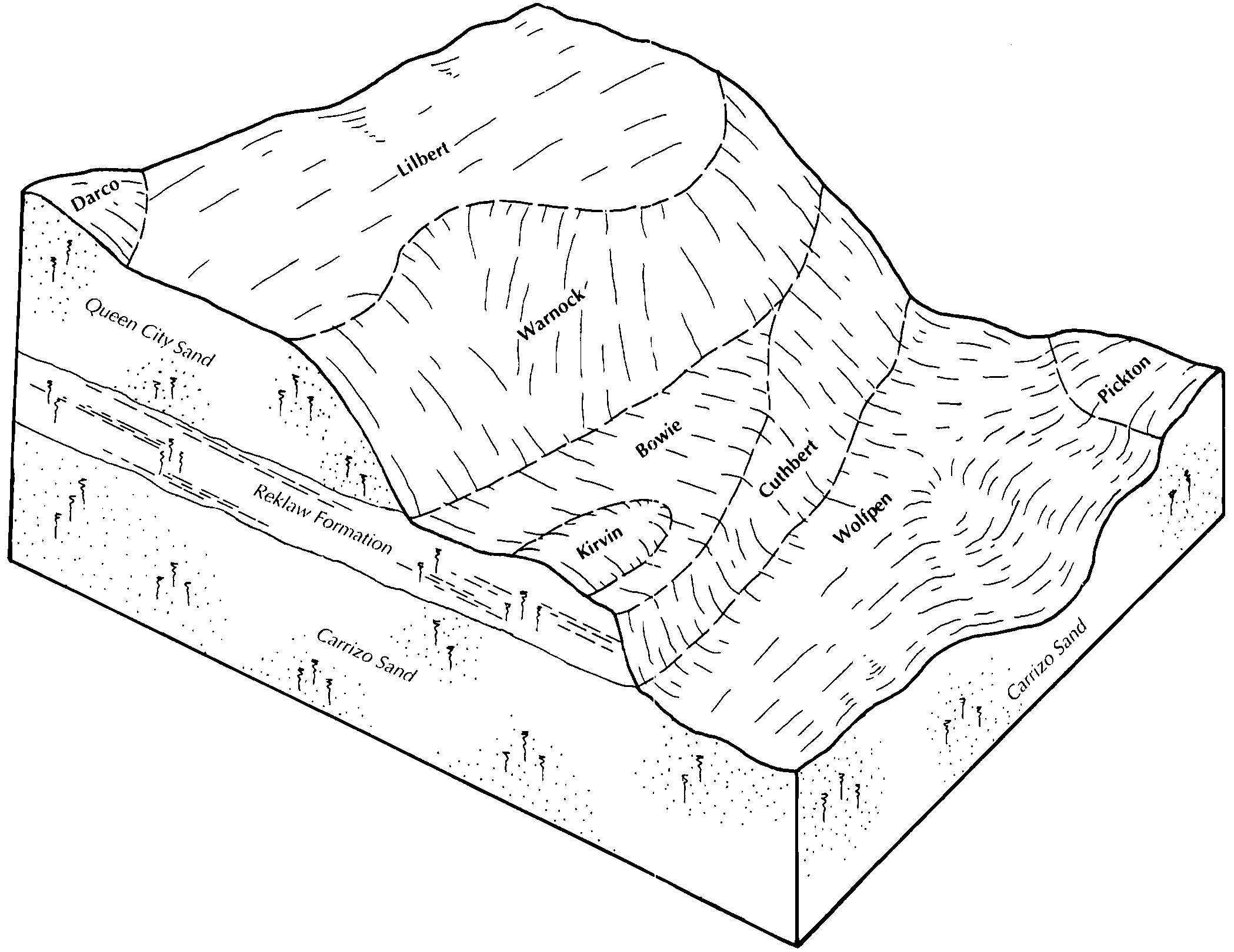
Bowie fine sandy loam, 3 to 8 percent slopes | 10 | 4187 | 3179341 | 2tf49 | ar019 | 1983 | 1:20000 |
Bowie fine sandy loam, 1 to 3 percent slopes | 9 | 2324 | 3179428 | 2wdl2 | ar019 | 1983 | 1:20000 |
Smithdale-Bowie-Sacul association, undulating | 77 | 36 | 3179414 | lypd | ar019 | 1983 | 1:20000 |
Bowie fine sandy loam, 3 to 8 percent slopes | BwC | 3150 | 565294 | 2tf49 | ar025 | 1965 | 1:15840 |
Bowie fine sandy loam, 1 to 3 percent slopes | BwB | 224 | 565293 | 2wdl2 | ar025 | 1965 | 1:15840 |
Bowie fine sandy loam, 3 to 8 percent slopes | 9 | 62418 | 565374 | 2tf49 | ar027 | 1983 | 1:20000 |
Bowie fine sandy loam, 1 to 3 percent slopes | 8 | 26099 | 565373 | 2wdl2 | ar027 | 1983 | 1:20000 |
Bowie fine sandy loam, 3 to 8 percent slopes | 3 | 10493 | 565655 | 2tf49 | ar057 | 1976 | 1:20000 |
Bowie fine sandy loam, 1 to 3 percent slopes | 2 | 4086 | 565644 | 2wdl2 | ar057 | 1976 | 1:20000 |
Smithdale-Bowie-Sacul association, undulating | 77 | 7028 | 3179304 | lypd | ar059 | 1983 | 1:20000 |
Bowie fine sandy loam, 1 to 3 percent slopes | 9 | 4110 | 3179318 | 2wdl2 | ar059 | 1983 | 1:20000 |
Bowie fine sandy loam, 3 to 8 percent slopes | 10 | 4108 | 3179231 | 2tf49 | ar059 | 1983 | 1:20000 |
Bowie fine sandy loam, 3 to 8 percent slopes | BoC | 28683 | 721509 | 2tf49 | ar099 | 2000 | 1:24000 |
Bowie fine sandy loam, 1 to 3 percent slopes | BoB | 5090 | 721508 | 2wdl2 | ar099 | 2000 | 1:24000 |
Bowie fine sandy loam, 1 to 3 percent slopes | 9 | 24548 | 564963 | 2wdl2 | ar670 | 1981 | 1:20000 |
Bowie fine sandy loam, 3 to 8 percent slopes | 10 | 24409 | 564882 | 2tf49 | ar670 | 1981 | 1:20000 |
Bowie fine sandy loam, 5 to 8 percent slopes | BoD | 23241 | 1724573 | 2y11w | la013 | 1992 | 1:24000 |
Bowie fine sandy loam, 1 to 5 percent slopes | BoC | 21069 | 1724572 | 2y11v | la013 | 1992 | 1:24000 |
Bowie fine sandy loam, 1 to 5 percent slopes | BoC | 17922 | 570984 | 2y11v | la015 | 2005 | 1:24000 |
Bowie fine sandy loam, 1 to 5 percent slopes | BoC | 17708 | 2805698 | 2y11v | la017 | 2013 | 1:24000 |
Bowie fine sandy loam, 5 to 8 percent slopes | BoD | 3761 | 2805699 | 2y11w | la017 | 2013 | 1:24000 |
Bowie fine sandy loam, 1 to 5 percent slopes | Bw | 19330 | 569311 | 2y11v | la027 | 1986 | 1:20000 |
Bowie fine sandy loam, 1 to 5 percent slopes | Bo | 872 | 1724524 | 2y11v | la031 | 1986 | 1:24000 |
Bowie fine sandy loam, 1 to 5 percent slopes | BoC | 15498 | 1725253 | 2y11v | la049 | 1991 | 1:24000 |
Bowie fine sandy loam, 1 to 5 percent slopes | BoC | 12511 | 571112 | 2y11v | la061 | 1991 | 1:24000 |
Bowie fine sandy loam, 5 to 8 percent slopes | BoD | 4132 | 571113 | 2y11w | la061 | 1991 | 1:24000 |
Bowie fine sandy loam, 1 to 5 percent slopes | BwC | 580 | 1903154 | 2y11v | la069 | 1983 | 1:24000 |
Bowie fine sandy loam, 5 to 8 percent slopes | BwD | 9 | 1903159 | 2y11w | la069 | 1983 | 1:24000 |
Bowie fine sandy loam, 1 to 5 percent slopes | BwC | 15548 | 1903025 | 2y11v | la085 | 1991 | 1:24000 |
Bowie fine sandy loam, 5 to 8 percent slopes | BwD | 4077 | 1903026 | 2y11w | la085 | 1991 | 1:24000 |
Bowie fine sandy loam, 1 to 5 percent slopes | Bh | 1438 | 1725325 | 2y11v | la111 | 1992 | 1:24000 |
Bowie fine sandy loam, 1 to 5 percent slopes | BnC | 1068 | 1725535 | 2y11v | la115 | 1992 | 1:24000 |
Bowie fine sandy loam, 1 to 5 percent slopes | BoB | 7991 | 575122 | 2y11v | tx001 | 1970 | 1:20000 |
Bowie fine sandy loam, 3 to 8 percent slopes | BoD | 7020 | 575123 | 2tf49 | tx001 | 1970 | 1:20000 |
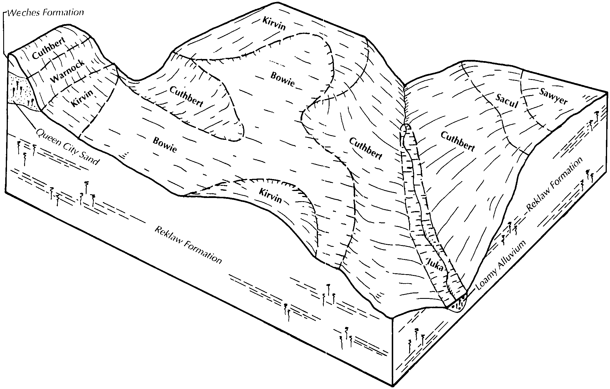
Bowie fine sandy loam, 3 to 8 percent slopes | Bn | 40460 | 575315 | 2tf49 | tx073 | 1949 | 1:20000 |
Bowie fine sandy loam, 1 to 3 percent slopes | Bm | 18258 | 575314 | 2wdl2 | tx073 | 1949 | 1:20000 |
Bowie fine sandy loam, sloping, eroded | Bo | 1786 | 575316 | m9nl | tx073 | 1949 | 1:20000 |
Bowie fine sandy loam, 1 to 5 percent slopes | BoC | 51133 | 576424 | 2y11v | tx203 | 1989 | 1:24000 |
Bowie fine sandy loam, 1 to 5 percent slopes | BwB | 6577 | 575493 | 2y11v | tx225 | 1994 | 1:24000 |
Bowie fine sandy loam, 1 to 8 percent slopes | 13 | 12051 | 575621 | 2tf48 | tx347 | 1976 | 1:24000 |
Bowie fine sandy loam, 1 to 8 percent slopes | Bo | 2775 | 575690 | 2tf48 | tx365 | 1971 | 1:20000 |
Bowie fine sandy loam, 1 to 5 percent slopes | BwB | 23424 | 578206 | 2y11v | tx401 | 1993 | 1:24000 |
Bowie fine sandy loam, 1 to 5 percent slopes | BwB | 2571 | 575756 | 2y11v | tx419 | 2002 | 1:24000 |
Bowie fine sandy loam, 1 to 5 percent slopes | BoB | 30913 | 575788 | 2y11v | tx423 | 1987 | 1:24000 |
Bowie fine sandy loam, 5 to 8 percent slopes | BoD | 5482 | 575789 | 2y11w | tx423 | 1987 | 1:24000 |
Bowie fine sandy loam, 1 to 5 percent slopes | BoC | 16286 | 576040 | 2y11v | tx499 | 1993 | 1:24000 |
Bowie fine sandy loam, 1 to 5 percent slopes | BoC | 74677 | 576085 | 2y11v | tx603 | 1984 | 1:24000 |
Bowie-Urban land complex, 2 to 5 percent slopes | BuC | 2375 | 576086 | mbgf | tx603 | 1984 | 1:24000 |
Bowie fine sandy loam, 1 to 5 percent slopes | BoC | 97860 | 576139 | 2y11v | tx608 | 1981 | 1:24000 |
Bowie-Urban land complex, 2 to 5 percent slopes | BuC | 12376 | 576140 | mbj5 | tx608 | 1981 | 1:24000 |
Bowie fine sandy loam, 1 to 5 percent slopes | BoC | 128182 | 576480 | 2y11v | tx616 | 2004 | 1:24000 |
Bowie fine sandy loam, 1 to 5 percent slopes | BoC | 11344 | 1894752 | 2y11v | tx619 | 2007 | 1:24000 |