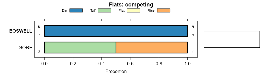
| Wilcox-Boswell complex, 5 to 15 percent slopes, eroded | WwD2 | 690 | 2247757 | 2ffz9 | al007 | 2007 | 1:24000 |
Luverne-Boswell complex, 15 to 45 percent slopes | LwF | 27330 | 328522 | c0vh | al021 | 1967 | 1:20000 |
Luverne-Boswell complex, 10 to 15 percent slopes, eroded | LwD2 | 13431 | 328521 | c0vg | al021 | 1967 | 1:20000 |
Luverne-Boswell complex, 2 to 10 percent slopes, eroded | LwC2 | 777 | 328520 | c0vf | al021 | 1967 | 1:20000 |
Boswell fine sandy loam, 5 to 12 percent slopes, moderately eroded | BgD2 | 1600 | 328618 | 2tjl7 | al023 | 1998 | 1:24000 |
Cuthbert, Boswell, and Eustis soils, 12 to 30 percent slopes | CdE | 10800 | 328971 | c19z | al045 | 1958 | 1:20000 |
Boswell very fine sandy loam, eroded, very gently sloping, moderately shallow | BdB2 | 1600 | 328960 | c19m | al045 | 1958 | 1:20000 |
Boswell very fine sandy loam, eroded, gently sloping, moderately shallow | BdC2 | 1400 | 328961 | c19n | al045 | 1958 | 1:20000 |
Boswell very fine sandy loam, eroded, sloping, moderately shallow | BdD2 | 716 | 328962 | c19p | al045 | 1958 | 1:20000 |
Boswell sandy clay, severely eroded, very gently sloping, moderately shallow | BcB3 | 517 | 328958 | c19k | al045 | 1958 | 1:20000 |
Boswell sandy clay, severely eroded, gently sloping, moderately shallow | BcC3 | 375 | 328959 | c19l | al045 | 1958 | 1:20000 |
Cuthbert, Boswell, and Eustis soils, eroded, sloping | CdD2 | 251 | 328970 | c19y | al045 | 1958 | 1:20000 |
Shubuta and Boswell fine sandy loams, sloping phases | Sc | 6410 | 329293 | c1nc | al051 | 1948 | 1:20000 |
Shubuta and Boswell fine sandy loams | Sb | 3887 | 329292 | c1nb | al051 | 1948 | 1:20000 |
Shubuta-Boswell complex, 15 to 50 percent slopes | ShE | 5591 | 329519 | c1wn | al057 | 1963 | 1:15840 |
Shubuta-Boswell complex, 10 to 15 percent slopes, eroded | ShD2 | 2861 | 329518 | c1wm | al057 | 1963 | 1:15840 |
Shubuta-Boswell complex, 6 to 10 percent slopes, eroded | ShC2 | 2130 | 329517 | c1wl | al057 | 1963 | 1:15840 |
Shubuta-Boswell complex, 8 to 12 percent slopes, eroded | SmD2 | 7651 | 329710 | c22t | al063 | 2013 | 1: |
Shubuta-Boswell complex, 8 to 12 percent slopes, severely eroded | SmD3 | 3062 | 329711 | c22v | al063 | 2013 | 1: |
Boswell fine sandy loam, 2 to 5 percent slopes, eroded | BoB2 | 759 | 329653 | c20z | al063 | 2013 | 1: |
Boswell fine sandy loam, 5 to 8 percent slopes, eroded | BoC2 | 749 | 329654 | c210 | al063 | 2013 | 1: |
Boswell clay loam, 2 to 8 percent slopes, severely eroded | BeC3 | 300 | 329652 | c20y | al063 | 2013 | 1: |
Boswell fine sandy loam, 6 to 15 percent slopes | BoD | 894 | 2494537 | 2psf6 | al075 | 2010 | 1:24000 |
Boswell clay loam, severely eroded, 8 to 20 percent slopes | BbE3 | 15405 | 330877 | c39g | al101 | 1958 | 1:20000 |
Cuthbert, Lakeland, and Boswell soils eroded, 12 to 30 percent slopes | CkE2 | 13680 | 330900 | c3b6 | al101 | 1958 | 1:20000 |
Boswell clay loam, severely eroded, gently sloping phase | BbD3 | 9511 | 330876 | c39f | al101 | 1958 | 1:20000 |
Boswell clay loam, severely eroded, very gently sloping phase | BbC3 | 6348 | 330875 | c39d | al101 | 1958 | 1:20000 |
Boswell fine sandy loam, eroded, very gently sloping phase | BcC2 | 5660 | 330879 | c39j | al101 | 1958 | 1:20000 |
Boswell fine sandy loam, eroded, nearly level phase | BcB2 | 3996 | 330878 | c39h | al101 | 1958 | 1:20000 |
Boswell fine sandy loam, eroded, gently sloping phase | BcD2 | 3387 | 330880 | c39k | al101 | 1958 | 1:20000 |
Cuthbert, Lakeland, and Boswell soils severely eroded, 12 to 30 percent slopes | CkE3 | 2908 | 330901 | c3b7 | al101 | 1958 | 1:20000 |
Cuthbert, Lakeland, and Boswell soils, eroded, 2 to 12 percent slopes | CkD2 | 2478 | 330898 | c3b4 | al101 | 1958 | 1:20000 |
Cuthbert, Lakeland, and Boswell soils, 12 to 30 percent slopes | CkE | 1105 | 330899 | c3b5 | al101 | 1958 | 1:20000 |
Boswell clay loam, severely eroded, nearly level phase | BbB3 | 605 | 330874 | c39c | al101 | 1958 | 1:20000 |
Boswell loam, 4 to 10 percent slopes | 11 | 6246 | 331503 | c3yn | al125 | 1980 | 1:20000 |
Boswell fine sandy loam, 5 to 12 percent slopes, eroded | BoD2 | 331 | 2642061 | 2rjr0 | al129 | 2013 | 1:24000 |
Boswell very fine sandy loam, gently sloping phase (sacul) | BwC | 1786 | 565144 | lz2g | ar011 | 1959 | 1:20000 |
Boswell gravelly fine sandy loam, gently sloping phase (sacul) | BgC | 1522 | 565139 | lz29 | ar011 | 1959 | 1:20000 |
Boswell very fine sandy loam, 8 to 20 percent slopes (sacul) | BwE | 1186 | 565146 | lz2j | ar011 | 1959 | 1:20000 |
Boswell gravelly fine sandy loam, eroded gently sloping phase (sacul) | BgC2 | 1054 | 565140 | lz2b | ar011 | 1959 | 1:20000 |
Boswell very fine sandy loam, nearly level phase (sacul) | BwB | 1024 | 565142 | lz2d | ar011 | 1959 | 1:20000 |
Boswell very fine sandy loam, eroded gently sloping phase (sacul) | BwC2 | 852 | 565145 | lz2h | ar011 | 1959 | 1:20000 |
Boswell very fine sandy loam, eroded nearly level phase (sacul) | BwB2 | 491 | 565143 | lz2f | ar011 | 1959 | 1:20000 |
Boswell gravelly fine sandy loam, nearly level phase (sacul) | BgB | 310 | 565138 | lz28 | ar011 | 1959 | 1:20000 |
Boswell sandy clay, severely eroded gently sloping phase (sacul) | BoC3 | 159 | 565141 | lz2c | ar011 | 1959 | 1:20000 |
Boswell loam, 3 to 8 percent slopes, eroded | BoC2 | 10792 | 565291 | lz76 | ar025 | 1965 | 1:15840 |
Boswell loam, 1 to 3 percent slopes, eroded | BoB2 | 4223 | 565290 | lz75 | ar025 | 1965 | 1:15840 |
Boswell loam, 8 to 20 percent slopes, eroded | BoE2 | 2619 | 565292 | lz77 | ar025 | 1965 | 1:15840 |
Boswell sandy loam, 5 to 8 percent slopes, eroded | BqC2 | 75 | 324960 | bx4l | ga283 | 1962 | 1:20000 |
Boswell sandy loam, 2 to 5 percent slopes, eroded | BqB2 | 65 | 324959 | bx4k | ga283 | 1962 | 1:20000 |
Boswell sandy loam, 2 to 5 percent slopes | BqB | 40 | 324958 | bx4j | ga283 | 1962 | 1:20000 |
Boswell-Susquehanna-Oktibbeha complex, 5 to 12 percent slopes, eroded | BrD2 | 6470 | 325882 | by3b | ga640 | 1965 | 1:15840 |
Boswell-Susquehanna-Oktibbeha complex, 2 to 5 percent slopes, eroded | BrB2 | 4145 | 325881 | by39 | ga640 | 1965 | 1:15840 |
Boswell-Susquehanna-Oktibbeha complex, 5 to 12 percent slopes, severely eroded | BrD3 | 950 | 325883 | by3c | ga640 | 1965 | 1:15840 |
Falkner-Boswell association, gently sloping | FBB | 7895 | 1720665 | 1vrhb | la081 | 1973 | 1:24000 |
Boswell-Falkner association, sloping | BFC | 4394 | 1720658 | 1vrh3 | la081 | 1973 | 1:24000 |
Boswell fine sandy loam, 5 to 8 percent slopes, eroded | BfC2 | 3173 | 331973 | c4ft | ms023 | 1963 | 1:15840 |
Boswell fine sandy loam, 2 to 5 percent slopes, eroded | BfB2 | 1492 | 331971 | c4fr | ms023 | 1963 | 1:15840 |
Boswell sandy clay loam, 5 to 8 percent slopes, severely eroded | BoC3 | 586 | 331976 | c4fx | ms023 | 1963 | 1:15840 |
Boswell fine sandy loam, 5 to 8 percent slopes | BfC | 559 | 331972 | 2tjl9 | ms023 | 1963 | 1:15840 |
Boswell fine sandy loam, 2 to 5 percent slopes | BfB | 358 | 331970 | 2w9wp | ms023 | 1963 | 1:15840 |
Boswell and Savannah soils, 2 to 8 percent slopes | BsC | 5575 | 332124 | c4lp | ms031 | 1962 | 1:15840 |
Boswell, Cuthbert, and Savannah soils, 8 to 17 percent slopes (boswell, sweatman, savannah) | BrD | 2006 | 332123 | c4ln | ms031 | 1962 | 1:15840 |
Boswell silt loam, 2 to 5 percent slopes | BoB | 1998 | 332119 | c4lj | ms031 | 1962 | 1:15840 |
Boswell silt loam, 5 to 8 percent slopes | BoC | 834 | 332120 | c4lk | ms031 | 1962 | 1:15840 |
Boswell silt loam, 8 to 17 percent slopes | BoD | 727 | 332122 | c4lm | ms031 | 1962 | 1:15840 |
Boswell silt loam, 5 to 8 percent slopes, eroded | BoC2 | 339 | 332121 | c4ll | ms031 | 1962 | 1:15840 |
Boswell fine sandy loam, 2 to 5 percent slopes, eroded | BoB2 | 20 | 2642167 | 2rrxv | ms041 | 2012 | 1:24000 |
Boswell-Tippah complex, 17 to 40 percent slopes (sweatman, tippah) | BtF | 3869 | 567834 | m1w7 | ms043 | 1965 | 1:15840 |
Tippah-Boswell complex, 8 to 12 percent slopes, eroded (tippah, sweatman) | TbD2 | 2359 | 567891 | m1y2 | ms043 | 1965 | 1:15840 |
Tippah-Boswell complex, 12 to 17 percent slopes, eroded (tippah sweatman) | TbE2 | 1625 | 567893 | m1y4 | ms043 | 1965 | 1:15840 |
Tippah-Boswell complex, 12 to 17 percent slopes (tippah, sweatman) | TbE | 1556 | 567892 | m1y3 | ms043 | 1965 | 1:15840 |
Tippah-Boswell complex, 8 to 12 percent slopes (tippah, sweatman) | TbD | 497 | 567890 | m1y1 | ms043 | 1965 | 1:15840 |
Boswell fine sandy loam, 5 to 8 percent slopes | BoC | 11253 | 332619 | 2tjl9 | ms061 | 1974 | 1:20000 |
Boswell fine sandy loam, 2 to 5 percent slopes | BoB | 2599 | 332618 | 2w9wp | ms061 | 1974 | 1:20000 |
Guin and Boswell soils, 17 to 40 percent slopes, eroded (saffell, sweatman) | GbF2 | 19456 | 568160 | m26r | ms085 | 1961 | 1:20000 |
Dulac and Boswell soils, 5 to 8 percent slopes, eroded (kolin and lorman) | DbC2 | 4800 | 568151 | m26g | ms085 | 1961 | 1:20000 |
Guin and Boswell soils, 17 to 40 percent slopes (saffell, sweatman) | GbF | 2183 | 568159 | m26q | ms085 | 1961 | 1:20000 |
Guin and Boswell soils, 8 to 12 percent slopes, eroded (saffell, sweatman) | GbD2 | 1696 | 568155 | m26l | ms085 | 1961 | 1:20000 |
Dulac and Boswell soils, 5 to 8 percent slopes (kolin and lorman) | DbC | 1612 | 568150 | m26f | ms085 | 1961 | 1:20000 |
Dulac and Boswell soils, 2 to 5 percent slopes, eroded (kolin and lorman) | DbB2 | 1528 | 568149 | m26d | ms085 | 1961 | 1:20000 |
Guin and Boswell soils, 12 to 17 percent slopes, eroded (saffell, sweatman) | GbE2 | 1173 | 568157 | m26n | ms085 | 1961 | 1:20000 |
Guin and Boswell soils, 17 to 40 percent slopes, severely eroded (saffell, sweatman) | GbF3 | 891 | 568161 | m26s | ms085 | 1961 | 1:20000 |
Dulac and Boswell soils, 5 to 8 percent slopes, severely eroded (kolin and lorman) | DbC3 | 642 | 568152 | m26h | ms085 | 1961 | 1:20000 |
Dulac and Boswell soils, 2 to 5 percent slopes (kolin and lorman) | DbB | 521 | 568148 | m26c | ms085 | 1961 | 1:20000 |
Guin and Boswell soils, 8 to 12 percent slopes, severely eroded (saffell, sweatman) | GbD3 | 369 | 568156 | m26m | ms085 | 1961 | 1:20000 |
Guin and Boswell soils, 12 to 17 percent slopes, severely eroded (saffell, sweatman) | GbE3 | 211 | 568158 | m26p | ms085 | 1961 | 1:20000 |
Boswell fine sandy loam, eroded gently sloping phase (5 to 8 percent slopes) | BcC2 | 1208 | 333302 | c5tp | ms101 | 1957 | 1:20000 |
Boswell fine sandy loam, eroded very gently sloping phase (2 to 5 percent slopes) | BcB2 | 275 | 333301 | c5tn | ms101 | 1957 | 1:20000 |
Boswell fine sandy loam, 2 to 5 percent slopes | BoB | 1950 | 333475 | 2w9wp | ms105 | 1968 | 1:20000 |
Boswell silt loam, 2 to 5 percent slopes, eroded | BoB2 | 1680 | 333681 | c66x | ms115 | 1969 | 1:20000 |
Boswell silt loam, 5 to 8 percent slopes, eroded | BoC2 | 974 | 333682 | c66y | ms115 | 1969 | 1:20000 |
Boswell loam, 5 to 8 percent slopes, eroded | BoC2 | 6484 | 334042 | c6lk | ms129 | 1997 | 1:20000 |
Boswell loam, 2 to 5 percent slopes, eroded | BoB2 | 3564 | 334041 | c6lj | ms129 | 1997 | 1:20000 |
Savannah-Boswell complex, 2 to 8 percent slopes | SB | 314 | 334064 | c6m8 | ms129 | 1997 | 1:20000 |
Shubuta and Boswell soils, 8 to 12 percent slopes, eroded | StD2 | 824 | 334333 | c6wy | ms147 | 1965 | 1:20000 |
Shubuta and Boswell soils, 5 to 8 percent slopes, eroded | StC2 | 306 | 334332 | c6wx | ms147 | 1965 | 1:20000 |
Shubuta and Boswell soils, 12 to 17 percent slopes | StE | 212 | 334334 | c6wz | ms147 | 1965 | 1:20000 |
Boswell fine sandy loam, 5 to 12 percent slopes, moderately eroded | BoC2 | 16483 | 2403465 | 2tjl7 | ms153 | 2008 | 1:24000 |
Boswell fine sandy loam, 2 to 5 percent slopes, eroded | BoB2 | 4879 | 2403464 | 2lp03 | ms153 | 2008 | 1:24000 |
Boswell silty clay, 8 to 12 percent slopes, severely eroded | BoD3 | 459 | 327522 | bzt7 | tn071 | 1961 | 1:15840 |
Boswell fine sandy loam, 2 to 8 percent slopes | BfC | 381 | 327519 | bzt4 | tn071 | 1961 | 1:15840 |
Boswell silty clay, 2 to 8 percent slopes, severely eroded | BoC3 | 349 | 327521 | bzt6 | tn071 | 1961 | 1:15840 |
Boswell fine sandy loam, 8 to 12 percent slopes | BfD | 293 | 327520 | bzt5 | tn071 | 1961 | 1:15840 |
Boswell soils, 12 to 25 percent slopes, eroded | BpE2 | 215 | 327523 | bzt8 | tn071 | 1961 | 1:15840 |