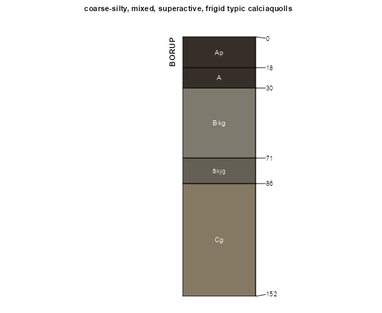
| Borup loam, 0 to 1 percent slopes | I5A | 10757 | 2798061 | prmm | mn027 | 1980 | 1:20000 |
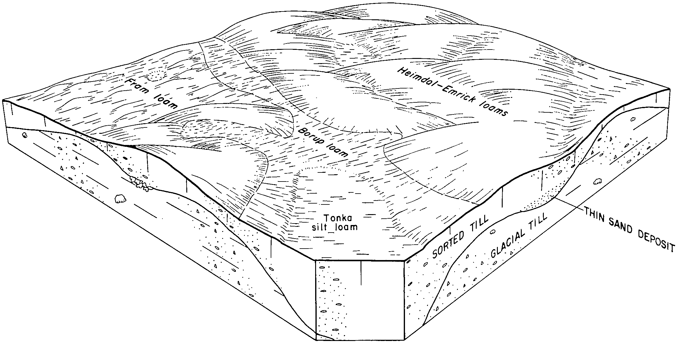
Borup loam | 46 | 50 | 356983 | czgl | mn027 | 1980 | 1:20000 |
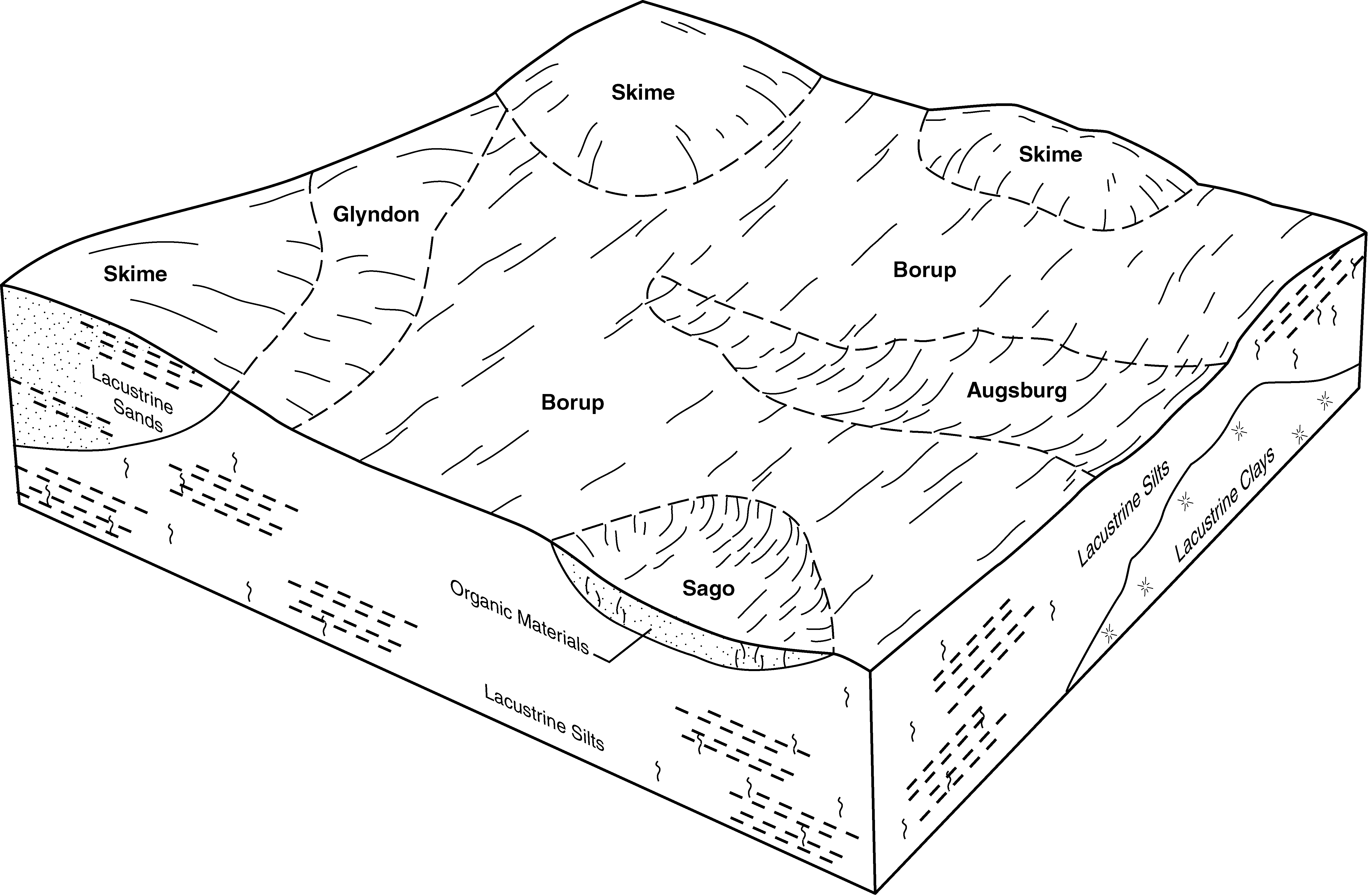
Borup-Glyndon loams, 0 to 2 percent slopes | I669A | 32 | 2798115 | 2qjyl | mn027 | 1980 | 1:20000 |
Borup-Rosewood complex, 0 to 1 percent slopes | I122A | 1134 | 2798866 | 21qd1 | mn069 | 2007 | 1:12000 |
Augsburg, Borup and Colvin soils, very poorly drained, 0 to 1 percent slopes | I110A | 237 | 2798855 | 21qcm | mn069 | 2007 | 1:12000 |
Borup very fine sandy loam, 0 to 1 percent slopes | I6A | 3836 | 2798895 | prmn | mn089 | 1994 | 1:20000 |
Augsburg, Borup and Colvin soils, very poorly drained, 0 to 1 percent slopes | I110A | 10 | 2798983 | 21qcm | mn089 | 1994 | 1:20000 |
Borup-Glyndon loams, 0 to 2 percent slopes | I669A | 9406 | 2799097 | 2qjyl | mn107 | 1970 | 1:20000 |
Augsburg, Borup and Colvin soils, very poorly drained, 0 to 1 percent slopes | I110A | 2404 | 2799076 | 21qcm | mn107 | 1970 | 1:20000 |
Borup loam, 0 to 1 percent slopes | I5A | 52 | 2799029 | prmm | mn107 | 1970 | 1:20000 |
Borup loam, depressional | Bo | 34 | 357209 | czpw | mn107 | 1970 | 1:20000 |
Borup very fine sandy loam, 0 to 1 percent slopes | I6A | 22 | 2799030 | prmn | mn107 | 1970 | 1:20000 |
Borup loam | 46 | 393 | 435846 | gmjk | mn111 | 1996 | 1:20000 |
Borup mucky silt loam, depressional | 1339 | 344 | 435616 | gm94 | mn111 | 1996 | 1:20000 |
Borup loam, 0 to 1 percent slopes | I5A | 53 | 2799128 | prmm | mn111 | 1996 | 1:20000 |
Borup loam, 0 to 1 percent slopes | I5A | 5756 | 2799168 | prmm | mn113 | 2003 | 1:12000 |
Borup very fine sandy loam, 0 to 1 percent slopes | I6A | 6043 | 2799229 | prmn | mn119 | 1996 | 1:20000 |
Augsburg, Borup and Colvin soils, very poorly drained, 0 to 1 percent slopes | I110A | 395 | 2799701 | 21qcm | mn119 | 1996 | 1:20000 |
Borup very fine sandy loam | 1299 | 65 | 352189 | ctgy | mn119 | 1996 | 1:20000 |
Borup loam, depressional | 348 | 3 | 352238 | ctjj | mn119 | 1996 | 1:20000 |
Borup very fine sandy loam, 0 to 1 percent slopes | I6A | 1409 | 2799752 | prmn | mn125 | 2001 | 1:12000 |
Borup loam, 0 to 1 percent slopes | I5A | 496 | 2799751 | prmm | mn125 | 2001 | 1:12000 |
Borup silt loam, Aspen Parkland, 0 to 1 percent slopes | I846A | 13066 | 2799880 | 2qjyn | mn135 | 1999 | 1:24000 |
Borup-Glyndon complex, 0 to 2 percent slopes | I682A | 10966 | 2799881 | 2qjyp | mn135 | 1999 | 1:24000 |
Augsburg, Borup and Colvin soils, very poorly drained, 0 to 1 percent slopes | I110A | 1152 | 2799867 | 21qcm | mn135 | 1999 | 1:24000 |
Borup silt loam | Bm | 1390 | 428319 | gcpr | mn149 | 1966 | 1:15840 |
Colvin-Borup complex, 0 to 1 percent slopes | I631A | 1385 | 2799922 | 2qktl | mn149 | 1966 | 1:15840 |
Borup silt loam, 0 to 1 percent slopes | I318A | 871 | 2799912 | 1nywl | mn149 | 1966 | 1:15840 |
Borup loam, 0 to 1 percent slopes | I5A | 809 | 2799930 | prmm | mn155 | 1986 | 1:20000 |
Borup loam, 0 to 1 percent slopes | I5A | 2299 | 2799977 | prmm | mn167 | 1985 | 1:20000 |
Colvin-Borup complex, saline, 0 to 1 percent slopes | G447A | 4631 | 2573612 | 2q5n4 | nd003 | 1988 | 1:20000 |
Colvin-Borup complex, saline, 0 to 1 percent slopes | F447A | 3565 | 2587600 | 2q55g | nd005 | | 1:12000 |
Borup loam, 0 to 1 percent slopes | F41A | 496 | 2587635 | 2q3w2 | nd005 | | 1:12000 |
Borup loam, 0 to 1 percent slopes | G41A | 440 | 2573806 | 2q4nk | nd005 | | 1:12000 |
Colvin-Borup complex, saline, 0 to 1 percent slopes | G447A | 220 | 2573690 | 2q5n4 | nd005 | | 1:12000 |
Colvin-Borup complex, saline, 0 to 1 percent slopes | F447A | 5112 | 2585877 | 2q55g | nd009 | 1981 | 1:20000 |
Colvin-Borup complex, saline, 0 to 1 percent slopes | G447A | 4383 | 2575043 | 2q5n4 | nd017 | 1983 | 1:20000 |
Borup silt loam, 0 to 1 percent slopes | I318A | 1867 | 2640871 | 1nywl | nd017 | 1983 | 1:20000 |
Borup silt loam, 0 to 1 percent slopes, frequently ponded | I316A | 311 | 2521574 | 1nywj | nd017 | 1983 | 1:20000 |
Colvin-Borup complex, saline, 0 to 1 percent slopes | G447A | 632 | 2575338 | 2q5n4 | nd021 | 1989 | 1:20000 |
Borup loam, 0 to 1 percent slopes | G41A | 840 | 2576237 | 2q4nk | nd027 | | 1:12000 |
Colvin-Borup complex, saline, 0 to 1 percent slopes | G447A | 22 | 2576309 | 2q5n4 | nd027 | | 1:12000 |
Colvin-Borup complex, saline, 0 to 1 percent slopes | G447A | 410 | 2576450 | 2q5n4 | nd031 | 1990 | 1:20000 |
Borup silt loam, 0 to 1 percent slopes | I318A | 2626 | 2642547 | 1nywl | nd035 | 1980 | 1:20000 |
Borup loam, 0 to 1 percent slopes | G41A | 1282 | 2577047 | 2q4nk | nd045 | 1966 | 1:20000 |
Colvin-Borup complex, saline, 0 to 1 percent slopes | F447A | 2265 | 2585575 | 2q55g | nd049 | 1987 | 1:20000 |
Colvin-Borup complex, saline, 0 to 1 percent slopes | G447A | 134 | 2571375 | 2q5n4 | nd049 | 1987 | 1:20000 |
Borup loam, 0 to 1 percent slopes | F41A | 10 | 2585620 | 2q3w2 | nd049 | 1987 | 1:20000 |
Borup loam, 0 to 1 percent slopes | G41A | 1526 | 2577277 | 2q4nk | nd063 | | 1:12000 |
Colvin-Borup complex, saline, 0 to 1 percent slopes | G447A | 875 | 2577333 | 2q5n4 | nd063 | | 1:12000 |
Colvin-Borup complex, saline, 0 to 1 percent slopes | F447A | 461 | 2587308 | 2q55g | nd063 | | 1:12000 |
Borup loam, 0 to 1 percent slopes | F41A | 158 | 2587326 | 2q3w2 | nd063 | | 1:12000 |
Borup silt loam, 0 to 1 percent slopes | I318A | 9929 | 2642967 | 1nywl | nd067 | 1972 | 1:20000 |
Borup loam, 0 to 1 percent slopes | F41A | 2389 | 2587200 | 2q3w2 | nd069 | 1975 | 1:20000 |
Colvin-Borup complex, saline, 0 to 1 percent slopes | F447A | 1716 | 2587174 | 2q55g | nd069 | 1975 | 1:20000 |
Colvin-Borup complex, saline, 0 to 1 percent slopes | G447A | 588 | 2582319 | 2q5n4 | nd069 | 1975 | 1:20000 |
Borup loam, 0 to 1 percent slopes | G41A | 250 | 2582277 | 2q4nk | nd069 | 1975 | 1:20000 |
Colvin-Borup complex, saline, 0 to 1 percent slopes | F447A | 6418 | 2587133 | 2q55g | nd071 | 1984 | 1:12000 |
Borup silt loam, 0 to 1 percent slopes | I318A | 16 | 2641284 | 1nywl | nd073 | 1992 | 1:20000 |
Borup loam, 0 to 1 percent slopes | G41A | 8 | 2581141 | 2q4nk | nd073 | 1992 | 1:20000 |
Borup silt loam, slightly saline, stratified substratum, 0 to 1 percent slopes | I203A | 6909 | 2641023 | 1nyry | nd077 | 2005 | 1:12000 |
Borup silt loam, 0 to 1 percent slopes | I318A | 2877 | 2641084 | 1nywl | nd077 | 2005 | 1:12000 |
Borup silt loam, moderately saline, stratified substratum, 0 to 1 percent slopes | I367A | 1625 | 2641013 | 1nyxv | nd077 | 2005 | 1:12000 |
Borup silt loam, slightly saline, stratified substratum, 0 to 1 percent slopes, frequently ponded | I205A | 792 | 2641168 | 1nys0 | nd077 | 2005 | 1:12000 |
Borup silt loam, 0 to 1 percent slopes, frequently ponded | I316A | 333 | 2640945 | 1nywj | nd077 | 2005 | 1:12000 |
Colvin-Borup complex, saline, 0 to 1 percent slopes | G447A | 26 | 2577394 | 2q5n4 | nd077 | 2005 | 1:12000 |
Colvin-Borup complex, saline, 0 to 1 percent slopes | F447A | 2763 | 2587995 | 2q55g | nd079 | 1990 | 1:24000 |
Borup loam, 0 to 1 percent slopes | F41A | 1 | 2588043 | 2q3w2 | nd079 | 1990 | 1:24000 |
Borup loam, 0 to 1 percent slopes | G41A | 1809 | 2579546 | 2q4nk | nd081 | 1959 | 1:12000 |
Borup silt loam, 0 to 1 percent slopes | I318A | 1256 | 2641213 | 1nywl | nd081 | 1959 | 1:12000 |
Colvin-Borup complex, saline, 0 to 1 percent slopes | G447A | 853 | 2579443 | 2q5n4 | nd081 | 1959 | 1:12000 |
Borup, Colvin, and Perella soils | Br | 134 | 341566 | cgf8 | nd081 | 1959 | 1:12000 |
Borup silt loam, slightly saline, stratified substratum, 0 to 1 percent slopes | I203A | 35 | 2641195 | 1nyry | nd081 | 1959 | 1:12000 |
Borup silt loam, 0 to 1 percent slopes, frequently ponded | I316A | 11 | 2641212 | 1nywj | nd081 | 1959 | 1:12000 |
Borup silt loam, 0 to 1 percent slopes | I318A | 15 | 2641374 | 1nywl | nd091 | 1991 | 1:20000 |
Colvin-Borup complex, saline, 0 to 1 percent slopes | G447A | 596 | 2581382 | 2q5n4 | nd093 | 1990 | 1:24000 |
Borup silt loam, 0 to 1 percent slopes | I318A | 6795 | 2641603 | 1nywl | nd097 | 1974 | 1:20000 |
Borup silt loam, moderately saline, 0 to 1 percent slopes | I188A | 449 | 2642467 | 2l6wt | nd097 | 1974 | 1:20000 |
Borup silt loam, 0 to 1 percent slopes | I318A | 1914 | 2642841 | 1nywl | nd099 | 1967 | 1:20000 |
Borup loam, 0 to 1 percent slopes | G41A | 5448 | 2579624 | 2q4nk | nd103 | 1966 | 1:12000 |
Borup loam, 0 to 1 percent slopes | C51A | 311 | 2566968 | 2q1ny | nd103 | 1966 | 1:12000 |
Colvin-Borup complex, saline, 0 to 1 percent slopes | G447A | 33 | 2579660 | 2q5n4 | nd103 | 1966 | 1:12000 |
Borup loam, 0 to 1 percent slopes | G041A | 2767 | 2797652 | 2q4nk | sd013 | 1987 | 1:20000 |
Colvin-Borup complex, saline, 0 to 1 percent slopes | G447A | 924 | 2797679 | 2q5n4 | sd013 | 1987 | 1:20000 |
Colvin-Borup complex, saline, 0 to 1 percent slopes | G447A | 13 | 2799300 | 2q5n4 | sd091 | 1970 | 1:20000 |
Borup silt loam | Bo | 2754 | 417806 | g0rm | sd109 | 1977 | 1:20000 |
Borup silt loam, 0 to 1 percent slopes | I318A | 1352 | 2800171 | 1nywl | sd109 | 1977 | 1:20000 |
Borup silt loam, moderately saline, stratified substratum, 0 to 1 percent slopes | I367A | 10 | 2800179 | 1nyxv | sd109 | 1977 | 1:20000 |
