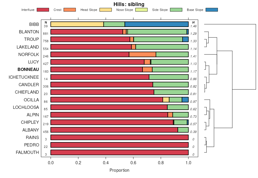
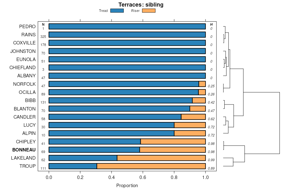
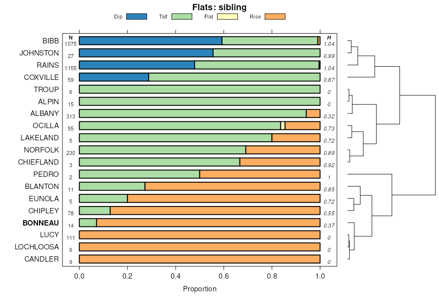
| Blanton-Bonneau complex, 0 to 5 percent slopes | BnB | 15740 | 328275 | c0lj | al005 | 2001 | 1:24000 |
Bonneau loamy sand, 0 to 5 percent slopes | BoB | 9080 | 328444 | 2tl15 | al013 | 1996 | 1:20000 |
Bonneau loamy sand, 5 to 8 percent slopes | BoC | 5030 | 328445 | 2v5m1 | al013 | 1996 | 1:20000 |
Bonneau loamy sand, 0 to 2 percent slopes | BoA | 2611 | 328719 | c11v | al035 | 1985 | 1:20000 |
Bonneau loamy sand, 0 to 5 percent slopes | BoB | 3040 | 328862 | 2tl15 | al041 | 2005 | 1:24000 |
Bonneau loamy fine sand, 0 to 5 percent slopes | 13 | 4902 | 329048 | c1dg | al047 | 1977 | 1:20000 |
Bonneau-Urban land complex, 0 to 5 percent slopes | 14 | 468 | 329049 | c1dh | al047 | 1977 | 1:20000 |
Bonneau loamy fine sand, 0 to 2 percent slopes | BoA | 750 | 329781 | c253 | al067 | 1986 | 1:20000 |
Bonneau loamy sand, 0 to 5 percent slopes | BoB | 5288 | 2514622 | 2tl15 | al085 | 2011 | 1:24000 |
Bonneau loamy sand, 5 to 8 percent slopes | BoC | 1321 | 2514623 | 2v5m1 | al085 | 2011 | 1:24000 |
Bonneau loamy fine sand, 0 to 5 percent slopes | BnB | 5630 | 330560 | c2z7 | al091 | 1997 | 1:24000 |
Bonneau loamy sand, 0 to 5 percent slopes | BoB | 1981 | 330913 | 2tl15 | al101 | 1958 | 1:20000 |
Bonneau-Eunola, occasionally flooded complex, 0 to 3 percent slopes | BoB | 5270 | 331299 | c3r2 | al109 | 1996 | 1:20000 |
Bonneau fine sand, 2 to 5 percent slopes | 39 | 14924 | 320723 | brqx | fl001 | 1982 | 1:15840 |
Jonesville-Cadillac-Bonneau complex, 0 to 5 percent slopes | 46 | 12202 | 320735 | brr9 | fl001 | 1982 | 1:15840 |
Troup-Bonneau-Penney complex, 5 to 8 percent slopes | 7 | 1165 | 1444865 | 1khhk | fl003 | 1991 | 1:20000 |
Bonneau fine sand, 2 to 5 percent slopes | 13 | 31560 | 797432 | 2w0q7 | fl023 | 1981 | 1:24000 |
Bonneau-Blanton complex, 2 to 5 percent slopes | 15 | 7780 | 797434 | vrsp | fl023 | 1981 | 1:24000 |
Blanton-Bonneau-Ichetucknee complex, 2 to 5 percent slopes | 11 | 5990 | 797430 | vrsk | fl023 | 1981 | 1:24000 |
Bonneau fine sand, 5 to 8 percent slopes | 14 | 3330 | 797433 | vrsn | fl023 | 1981 | 1:24000 |
Blanton-Bonneau-Ichetucknee complex, 5 to 8 percent slopes | 12 | 1210 | 797431 | vrsl | fl023 | 1981 | 1:24000 |
Bonneau-Blanton complex, 5 to 8 percent slopes | 16 | 410 | 797435 | vrsq | fl023 | 1981 | 1:24000 |
Bonneau-Leefield-Norfolk complex, 0 to 5 percent slopes | 12 | 1314 | 1381552 | 1hcm6 | fl039 | 2006 | 1:12000 |
Bonneau-Blanton fine sands, 0 to 5 percent slopes | 34 | 4375 | 321815 | bsw4 | fl041 | 1989 | 1:20000 |
Eunola-Bonneau fine sands, 0 to 5 percent slopes | 33 | 3840 | 321814 | bsw3 | fl041 | 1989 | 1:20000 |
Bonneau fine sand, 0 to 5 percent slopes | 21 | 2860 | 321804 | 2v17x | fl041 | 1989 | 1:20000 |
Bonneau sand, 0 to 5 percent slopes | 29 | 1460 | 1148825 | 17kfw | fl047 | 1995 | 1:24000 |
Millhopper-Bonneau complex, 1 to 5 percent slopes | 62 | 4110 | 1414105 | 1jgh9 | fl075 | 1990 | 1:24000 |
Bonneau fine sand, 0 to 5 percent slopes | 49 | 1020 | 323415 | 2v17y | fl107 | 1985 | 1:15840 |
Blanton-Alpin-Bonneau complex, 0 to 5 percent slopes | 13 | 90031 | 1023328 | 2w4gj | fl121 | 2003 | 1:24000 |
Bonneau-Blanton-Padlock complex, 0 to 5 percent slopes | 11 | 57387 | 1023326 | 2w4gb | fl121 | 2003 | 1:24000 |
Blanton-Bonneau complex, 0 to 5 percent slopes | 5 | 31778 | 1023323 | 2y51t | fl121 | 2003 | 1:24000 |
Falmouth-Bonneau-Blanton complex, 0 to 5 percent slopes | 17 | 22151 | 1023331 | 13bvp | fl121 | 2003 | 1:24000 |
Blanton-Lynchburg-Bonneau Complex, 0 to 5 percent slopes | 15 | 4982 | 1023330 | 13bvn | fl121 | 2003 | 1:24000 |
Blanton-Bonneau complex, 5 to 8 percent slopes | 14 | 3646 | 1023329 | 13bvm | fl121 | 2003 | 1:24000 |
Falmouth-Bonneau-Blanton complex, 5 to 8 percent slopes | 34 | 1892 | 1023348 | 13bw7 | fl121 | 2003 | 1:24000 |
Bonneau fine sand, 0 to 5 percent slopes | 80 | 1233 | 1023394 | 2v17x | fl121 | 2003 | 1:24000 |
Blanton-Bonneau-Ichetucknee complex, 2 to 5 percent slopes | 81 | 205 | 1023395 | 13bxr | fl121 | 2003 | 1:24000 |
Bonneau fine sand, 6 to 10 percent slopes | 41 | 430 | 1414605 | 1jh0f | fl125 | 1989 | 1:15840 |
Bonneau-Norfolk-Angie complex, 5 to 12 percent slopes | 38 | 20210 | 324008 | bw4w | fl131 | 1985 | 1:20000 |
Bonneau loamy sand, 0 to 5 percent slopes | 47 | 10970 | 324018 | bw56 | fl131 | 1985 | 1:20000 |
Blanton-Bonneau complex, 0 to 5 percent slopes | 128 | 10460 | 2424627 | 2md0s | fl133 | 2009 | 1:12000 |
Blanton-Bonneau complex, 5 to 8 percent slopes | 129 | 6180 | 2424629 | 2md0v | fl133 | 2009 | 1:12000 |
Bonneau loamy sand, 0 to 5 percent slopes | BoB | 43020 | 754245 | 2tl15 | ga087 | 2001 | 1:24000 |
Bonneau loamy sand, 5 to 12 percent slopes | BoD | 3860 | 754246 | t9vj | ga087 | 2001 | 1:24000 |
Bonneau loamy sand, 0 to 5 percent slopes | BoB | 13651 | 336586 | 2tl15 | ga131 | 2000 | 1:12000 |
Bonneau loamy sand, 5 to 12 percent slopes | BoD | 1526 | 336587 | c97n | ga131 | 2000 | 1:12000 |
Bonneau loamy sand, 0 to 5 percent slopes | BoB | 965 | 581276 | 2tl15 | ga243 | 2002 | 1:24000 |
Bonneau loamy sand, 0 to 5 percent slopes | BoB | 6455 | 2425335 | 2tl15 | ga259 | 2009 | 1:12000 |
Bonneau loamy sand, 5 to 8 percent slopes | BoC | 1925 | 2425337 | 2v5m1 | ga259 | 2009 | 1:12000 |
Bonneau loamy sand, 0 to 5 percent slopes | BoB | 2970 | 2455407 | 2tl15 | ga307 | 2009 | 1:12000 |
Bonneau loamy sand, 5 to 8 percent slopes | BoC | 715 | 2455408 | 2nf1q | ga307 | 2009 | 1:12000 |
Bonneau loamy sand, 0 to 2 percent slopes | BoA | 15225 | 325138 | bxbb | ga603 | 1981 | 1:20000 |
Bonneau-Lucy complex, 6 to 15 percent slopes | BoD | 2255 | 2639036 | 2rj2j | ga639 | 2012 | 1:24000 |
Bonneau loamy sand, 0 to 5 percent slopes | BoB | 4735 | 1605069 | 2tl15 | ga658 | 2005 | 1:24000 |
Bonneau loamy sand, 0 to 4 percent slopes | BoB | 2250 | 111548 | 3r2b | nc013 | 1986 | 1:24000 |
Bonneau loamy sand, 0 to 6 percent slopes | BoB | 4710 | 111395 | 3qxd | nc015 | 1984 | 1:24000 |
Bonneau loamy sand, 6 to 10 percent slopes | BoC | 475 | 111396 | 3qxf | nc015 | 1984 | 1:24000 |
Bonneau loamy fine sand, 0 to 6 percent slopes | BoB | 3444 | 115927 | 3wml | nc073 | 1990 | 1:24000 |
Bonneau loamy fine sand, 0 to 4 percent slopes | BoB | 14996 | 113024 | 3sly | nc083 | 1995 | 1:24000 |
Bonneau loamy sand, 0 to 6 percent slopes | BoB | 7288 | 113151 | 3sr1 | nc091 | 1981 | 1:24000 |
Bonneau loamy sand, 6 to 12 percent slopes | BoC | 2616 | 113152 | 3sr2 | nc091 | 1981 | 1:24000 |
Bonneau sand, 0 to 3 percent slopes | BoA | 7996 | 113521 | 3t3z | nc101 | 1986 | 1:24000 |
Bonneau loamy sand, 0 to 6 percent slopes | BoB | 14369 | 111120 | 3qmj | nc117 | 1985 | 1:24000 |
Bonneau loamy sand, 6 to 12 percent slopes | BoC | 2615 | 111121 | 3qmk | nc117 | 1985 | 1:24000 |
Bonneau loamy sand, 0 to 4 percent slopes | BoB | 14399 | 110894 | 3qd7 | nc127 | 1984 | 1:24000 |
Bonneau loamy sand, 0 to 6 percent slopes | BoB | 24162 | 114027 | 3tn9 | nc131 | 1988 | 1:24000 |
Bonneau loamy sand, 6 to 12 percent slopes | BoC | 3553 | 114028 | 3tnb | nc131 | 1988 | 1:24000 |
Bonneau fine sand, 0 to 2 percent slopes | BoA | 17070 | 132360 | 4fqp | sc005 | 1989 | 1:20000 |
Bonneau fine sand, 2 to 6 percent slopes | BoB | 15292 | 132361 | 4fqq | sc005 | 1989 | 1:20000 |
Bonneau sand, 0 to 2 percent slopes | BoA | 14320 | 138098 | 4mps | sc009 | 1997 | 1:24000 |
Bonneau sand, 2 to 6 percent slopes | BoB | 6044 | 138099 | 4mpt | sc009 | 1997 | 1:24000 |
Bonneau loamy sand, 2 to 6 percent slopes | BoB | 32000 | 131942 | 4f96 | sc015 | 1974 | 1:20000 |
Bonneau loamy sand, 0 to 2 percent slopes | BoA | 17000 | 131941 | 4f95 | sc015 | 1974 | 1:20000 |
Lucy loamy sand, 0 to 6 percent slopes | LuB | 825 | 131959 | 4f9r | sc015 | 1974 | 1:20000 |
Bonneau sand, 0 to 4 percent slopes | BoB | 1584 | 131994 | 4fbw | sc025 | 1989 | 1:20000 |
Bonneau fine sand, 0 to 2 percent slopes | 16A | 15579 | 132258 | 4fmd | sc029 | 1980 | 1:20000 |
Bonneau fine sand, 2 to 6 percent slopes | 16B | 5057 | 132259 | 4fmf | sc029 | 1980 | 1:20000 |
Bonneau sand, 0 to 6 percent slopes | BoB | 15303 | 618788 | nrwx | sc031 | 1998 | 1:24000 |
Bonneau fine sand, 0 to 2 percent slopes | BoA | 6700 | 129787 | 4c1p | sc035 | 1985 | 1:20000 |
Bonneau fine sand, 2 to 6 percent slopes | BoB | 2200 | 129788 | 4c1q | sc035 | 1985 | 1:20000 |
Bonneau fine sand, 0 to 2 percent slopes | BoA | 21025 | 130090 | 4ccg | sc049 | 1990 | 1:20000 |
Bonneau fine sand, 2 to 6 percent slopes | BoB | 5035 | 130091 | 4cch | sc049 | 1990 | 1:20000 |
Bonneau loamy sand, 0 to 2 percent slopes | BnA | 3310 | 132535 | 4fxb | sc053 | 1975 | 1:20000 |
Bonneau sand, 0 to 6 percent slopes | BoB | 2333 | 1606513 | 1qxq0 | sc061 | 2005 | 1:24000 |
Bonneau sand, 0 to 4 percent slopes | BoB | 7130 | 130608 | 4cx5 | sc069 | 1995 | 1:24000 |
Bonneau sand, 0 to 4 percent slopes | BoB | 35521 | 130876 | 4d5t | sc075 | 1985 | 1:20000 |
Bonneau-Norfolk complex, 0 to 6 percent slopes | BoB | 715 | 2485885 | 2pfrv | sc085 | 1969 | 1:20000 |
Bonneau fine sand, 0 to 2 percent slopes | BnA | 2220 | 131503 | 4dv1 | sc089 | 1985 | 1:20000 |
Bonneau loamy sand, 0 to 6 percent slopes | 7B | 4960 | 120347 | 4175 | va149 | 1980 | 1:15840 |
Bonneau loamy sand, 6 to 10 percent slopes | 7C | 594 | 120348 | 4176 | va149 | 1980 | 1:15840 |


