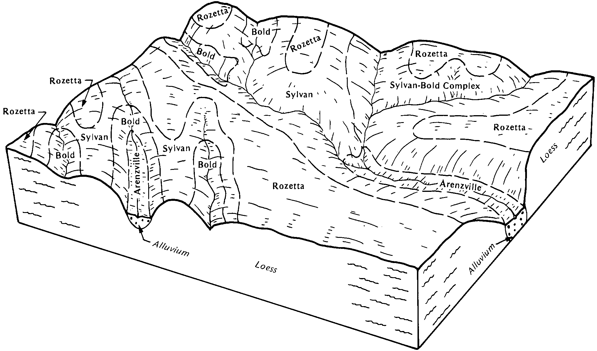
| Sylvan-Bold complex, 10 to 18 percent slopes, severely eroded | 962D3 | 8540 | 262827 | 8th9 | il017 | 2003 | 1:12000 |
Sylvan-Bold silt loams, 18 to 25 percent slopes, eroded | 962E2 | 6839 | 262828 | 8thb | il017 | 2003 | 1:12000 |
Tallula-Bold silt loams, 10 to 18 percent slopes, eroded | 965D2 | 4875 | 262830 | 8thd | il017 | 2003 | 1:12000 |
Sylvan-Bold Complex, 5 to 10 percent slopes, severely eroded | 962C3 | 4006 | 262826 | 8th8 | il017 | 2003 | 1:12000 |
Sylvan-Bold silt loams, 10 to 18 percent slopes, eroded | 962D2 | 2546 | 780783 | v6gk | il017 | 2003 | 1:12000 |
Sylvan-Bold silt loams, 18 to 35 percent slopes | 962F | 577 | 758469 | tg7r | il017 | 2003 | 1:12000 |
Tallula-Bold silt loams, 18 to 35 percent slopes | 965F | 526 | 262831 | 8thf | il017 | 2003 | 1:12000 |
Alford-Bold complex, 7 to 12 percent slopes, eroded | 985D2 | 158 | 211712 | 739f | il059 | 1966 | 1:20000 |
Sylvan-Bold silt loams, 35 to 60 percent slopes | 962G | 4669 | 211793 | 73d1 | il061 | 1968 | 1:15840 |
Sylvan-Bold silt loams, 18 to 25 percent slopes, eroded | 962E2 | 1495 | 211792 | 73d0 | il061 | 1968 | 1:15840 |
Sylvan-Bold silt loams, 18 to 35 percent slopes | 962F | 1171 | 211791 | 73cz | il061 | 1968 | 1:15840 |
Sylvan-Bold silt loams, 10 to 18 percent slopes, eroded | 962D2 | 1051 | 211790 | 73cy | il061 | 1968 | 1:15840 |
Sylvan-Bold complex, 10 to 18 percent slopes, severely eroded | 962D3 | 3084 | 244783 | 86q7 | il073 | 2001 | 1:12000 |
Sylvan-Bold silt loams, 35 to 60 percent slopes | 962G | 3651 | 728443 | sg05 | il083 | 2002 | 1:12000 |
Sylvan-Bold silt loams, 18 to 35 percent slopes | 962F | 1916 | 728442 | sg04 | il083 | 2002 | 1:12000 |
Sylvan-Bold silt loams, 18 to 25 percent slopes, eroded | 962E2 | 1605 | 728445 | sg07 | il083 | 2002 | 1:12000 |
Sylvan-Bold silt loams, 10 to 18 percent slopes, eroded | 962D2 | 914 | 728439 | sg01 | il083 | 2002 | 1:12000 |
Sylvan-Bold complex, 10 to 18 percent slopes, severely eroded | 962D3 | 217 | 728441 | sg03 | il083 | 2002 | 1:12000 |
Sylvan-Bold complex, terrace, 10 to 18 percent slopes, severely eroded | 9962D3 | 147 | 728475 | sg16 | il083 | 2002 | 1:12000 |
Tallula-Bold silt loams, 10 to 18 percent slopes, eroded | 965D2 | 587 | 1596061 | 1qktv | il107 | 2006 | 1:12000 |
Tallula-Bold silt loams, 5 to 10 percent slopes, eroded | 965C2 | 132 | 1596060 | 1qktt | il107 | 2006 | 1:12000 |
Sylvan-Bold silt loams, 18 to 35 percent slopes, eroded | 962F2 | 4130 | 198923 | 6nzw | il119 | 2001 | 1:12000 |
Sylvan-Bold silt loams, 10 to 18 percent slopes, eroded | 962D2 | 1955 | 198922 | 6nzv | il119 | 2001 | 1:12000 |
Bold silt loam, 18 to 35 percent slopes | 35F | 391 | 198941 | 6p0g | il119 | 2001 | 1:12000 |
Tallula-Bold silt loams, 10 to 18 percent slopes, eroded | 965D2 | 986 | 177829 | 5z1f | il125 | 1989 | 1:15840 |
Tallula-Bold silt loams, 5 to 10 percent slopes, eroded | 965C2 | 4310 | 1406149 | 1j66n | il129 | 2005 | 1:12000 |
Sylvan-Bold silt loams, 10 to 18 percent slopes, eroded | 962D2 | 3928 | 1406116 | 1j65l | il129 | 2005 | 1:12000 |
Sylvan-Bold silt loams, 5 to 10 percent slopes, eroded | 962C2 | 3071 | 1486967 | 1lx9p | il129 | 2005 | 1:12000 |
Sylvan-Bold silt loams, 18 to 35 percent slopes, eroded | 962F2 | 2859 | 1486744 | 1lx2h | il129 | 2005 | 1:12000 |
Sylvan-Bold complex, 5 to 10 percent slopes, severely eroded | 962C3 | 2771 | 1406054 | 1j63l | il129 | 2005 | 1:12000 |
Sylvan-Bold complex, 10 to 18 percent slopes, severely eroded | 962D3 | 1610 | 1406123 | 1j65t | il129 | 2005 | 1:12000 |
Sylvan-Bold silt loams, 35 to 60 percent slopes | 962G | 395 | 1406044 | 1j638 | il129 | 2005 | 1:12000 |
Sylvan-Bold silt loams, 18 to 25 percent slopes, eroded | 962E2 | 296 | 1488479 | 1lywg | il129 | 2005 | 1:12000 |
Tallula-Bold silt loams, 10 to 18 percent slopes, eroded | 965D2 | 268 | 1406150 | 1j66p | il129 | 2005 | 1:12000 |
Sylvan-Bold complex, 10 to 18 percent slopes, severely eroded | 962D3 | 3350 | 245019 | 86yv | il131 | 2000 | 1:12000 |
Sylvan-Bold complex, 18 to 25 percent slopes, severely eroded | 962E3 | 3012 | 1672188 | 1t41k | il137 | 1984 | 1:15840 |
Sylvan-Bold silt loams, 18 to 25 percent slopes, eroded | 962E2 | 2014 | 1672187 | 1t41j | il137 | 1984 | 1:15840 |
Sylvan-Bold complex, 10 to 18 percent slopes, severely eroded | 962D3 | 1062 | 1672186 | 1t41h | il137 | 1984 | 1:15840 |
Sylvan-Bold silt loams, 10 to 18 percent slopes, eroded | 962D2 | 73 | 2542163 | 2qvjq | il137 | 1984 | 1:15840 |
Sylvan-Bold complex, 5 to 10 percent slopes, severely eroded | 962C3 | 51 | 2542162 | 2qvjp | il137 | 1984 | 1:15840 |
Sylvan-Bold silt loams, 18 to 35 percent slopes | 962F | 1312 | 198764 | 6ntr | il161 | 2002 | 1:12000 |
Sylvan-Bold silt loams, 18 to 35 percent slopes, eroded | 962F2 | 4825 | 183198 | 64mm | il163 | 1997 | 1:12000 |
Sylvan-Bold silt loams, 35 to 60 percent slopes | 962G | 1941 | 183200 | 64mp | il163 | 1997 | 1:12000 |
Sylvan-Bold silt loams, 18 to 25 percent slopes, eroded | 962E2 | 3395 | 2542083 | 2qrcm | il171 | 1984 | 1:12000 |
Sylvan-Bold complex, 18 to 25 percent slopes, severely eroded | 962E3 | 1243 | 2542084 | 2qrcn | il171 | 1984 | 1:12000 |
Sylvan-Bold complex, 10 to 18 percent slopes, severely eroded | 962D3 | 800 | 2542082 | 2qrcl | il171 | 1984 | 1:12000 |
Sylvan-Bold silt loams, 10 to 18 percent slopes, eroded | 962D2 | 9 | 2542081 | 2qrck | il171 | 1984 | 1:12000 |
Bold-Truman silt loams, 12 to 18 percent slopes | 909D | 286 | 396212 | f991 | mn013 | 1975 | 1:12000 |
Bold-Truman silt loams, 6 to 12 percent slopes | 909C | 256 | 396211 | f990 | mn013 | 1975 | 1:12000 |
Timula-Bold silt loams, 12 to 18 percent slopes, eroded | 963D2 | 832 | 396910 | fb0k | mn037 | 1980 | 1:15840 |
Timula-Bold silt loams, 6 to 12 percent slopes, eroded | 963C2 | 821 | 396909 | fb0j | mn037 | 1980 | 1:15840 |
Timula-Bold silt loams, 18 to 25 percent slopes, eroded | 963E2 | 606 | 396911 | fb0l | mn037 | 1980 | 1:15840 |
Truman-Bold complex, 6 to 12 percent slopes, eroded | 909C2 | 2580 | 397124 | fb7g | mn043 | 1989 | 1:20000 |
Bold-Truman complex, 12 to 18 percent slopes, eroded | 909D2 | 517 | 397125 | fb7h | mn043 | 1989 | 1:20000 |
Truman-Bold silt loams, 6 to 12 percent slopes | 909C | 685 | 400064 | ff99 | mn091 | 1985 | 1:20000 |
Bold-Truman silt loams, 12 to 18 percent slopes, eroded | 909D2 | 137 | 400065 | ff9b | mn091 | 1985 | 1:20000 |
Bold-Truman complex, 6 to 12 percent slopes, eroded | 909C2 | 928 | 436461 | gn5d | mn093 | 1996 | 1:20000 |
Gardencity-Bold complex, 6 to 12 percent slopes, eroded | 1177C | 465 | 436203 | gmx2 | mn093 | 1996 | 1:20000 |
Bold-Truman complex, 12 to 18 percent slopes, eroded | 909D2 | 295 | 436462 | gn5f | mn093 | 1996 | 1:20000 |
Timula-Bold complex, 6 to 12 percent slopes, eroded | 963C2 | 1191 | 429744 | gf5q | mn131 | 1996 | 1:12000 |
Timula-Bold complex, 12 to 18 percent slopes, eroded | 963D2 | 200 | 429746 | gf5s | mn131 | 1996 | 1:12000 |
Seaton-Bold soils, 12 to 18 percent slopes, moderately eroded | SbD2 | 31 | 2216431 | 2ddcs | mn157 | 2008 | 1:12000 |
Bold-Truman silt loams, 5 to 12 percent slopes, eroded | 909C2 | 626 | 428968 | gdcp | mn165 | 1987 | 1:20000 |