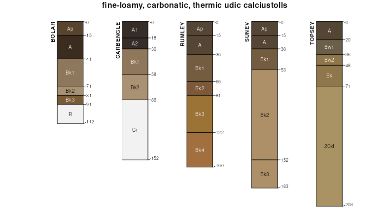
| Bolar gravelly clay loam, 1 to 4 percent slopes | BlC | 44 | 608495 | 2tc2l | tx027 | 1972 | 1:24000 |
Bolar clay loam, 1 to 3 percent slopes | BcB | 1926 | 363034 | 2tc2f | tx035 | 1977 | 1:24000 |
Bolar clay loam, 3 to 5 percent slopes | BcC | 1292 | 363035 | 2tc2h | tx035 | 1977 | 1:24000 |
Purves-Bolar association, 1 to 8 percent slopes | PXD | 81652 | 364401 | 30bzx | tx093 | 1974 | 1:20000 |
Bolar clay loam, 3 to 5 percent slopes | BcC | 10030 | 364354 | 2tc2h | tx093 | 1974 | 1:20000 |
Brackett-Bolar complex, 1 to 5 percent slopes | BrC | 6940 | 364358 | d74h | tx093 | 1974 | 1:20000 |
Bolar clay loam, 1 to 3 percent slopes | BcB | 3854 | 364353 | 2tc2f | tx093 | 1974 | 1:20000 |
Bolar clay loam, 5 to 8 percent slopes | BcD | 2148 | 364355 | 2tc2k | tx093 | 1974 | 1:20000 |
Bolar-Aledo complex, 3 to 20 percent slopes | 10 | 17582 | 364457 | 2tc2m | tx097 | 1973 | 1:24000 |
Bolar clay loam, 1 to 5 percent slopes | 7 | 12224 | 364522 | 2tc2g | tx097 | 1973 | 1:24000 |
Bolar stony clay loam, 5 to 12 percent slopes | 9 | 2530 | 364539 | d7bb | tx097 | 1973 | 1:24000 |
Bolar clay loam, 5 to 8 percent slopes | 8 | 2455 | 364533 | 2tc2k | tx097 | 1973 | 1:24000 |
Bolar gravelly clay loam, 1 to 4 percent slopes | BgB | 30175 | 391144 | 2tc2l | tx099 | 1983 | 1:24000 |
Bolar clay loam, 3 to 5 percent slopes | 17 | 2477 | 364966 | 2tc2h | tx121 | 1975 | 1:24000 |
Bolar clay loam, 1 to 3 percent slopes | 16 | 1788 | 364965 | 2tc2f | tx121 | 1975 | 1:24000 |
Bolar clay loam, 1 to 3 percent slopes | BcB | 7601 | 365224 | 2tc2f | tx133 | 1972 | 1:20000 |
Bolar-Denton complex 3 to 5 percent slopes | BdC | 13477 | 365352 | 30knb | tx143 | 1966 | 1:20000 |
Bolar-Aledo complex, 3 to 20 percent slopes | 15 | 3024 | 366649 | 2tc2m | tx181 | 1977 | 1:20000 |
Bolar clay loam, 1 to 5 percent slopes | 13 | 1367 | 366647 | 2tc2g | tx181 | 1977 | 1:20000 |
Bolar clay loam, 5 to 8 percent slopes | 14 | 788 | 366648 | 2tc2k | tx181 | 1977 | 1:20000 |
Bolar gravelly clay loam, 1 to 4 percent slopes | BgB | 4179 | 376645 | 2tc2l | tx193 | 1994 | 1:24000 |
Bolar-Sunev complex, 3 to 5 percent slopes | 19 | 5144 | 367730 | dbn8 | tx217 | 1975 | 1:20000 |
Bolar clay loam, 3 to 8 percent slopes | 18 | 3614 | 367729 | 2tc2j | tx217 | 1975 | 1:20000 |
Bolar clay loam, 1 to 3 percent slopes | 17 | 2256 | 367728 | 2tc2f | tx217 | 1975 | 1:20000 |
Aledo-Bolar association, 1 to 8 percent slopes | AbC | 70482 | 368146 | 2tc39 | tx251 | 1981 | 1:20000 |
Bolar clay loam, 3 to 8 percent slopes | BoC | 12899 | 368152 | 2tc2j | tx251 | 1981 | 1:20000 |
Bolar-Aledo complex, 3 to 20 percent slopes | BpE | 9461 | 368153 | 2tc2m | tx251 | 1981 | 1:20000 |
Bolar clay loam, 1 to 3 percent slopes | BoB | 7695 | 368151 | 2tc2f | tx251 | 1981 | 1:20000 |
Bolar clay loam, 1 to 3 percent slopes | BoB | 4241 | 368846 | 2tc2f | tx281 | 1990 | 1:24000 |
Bolar clay loam, 3 to 5 percent slopes | BoC | 161 | 368847 | 2tc2h | tx281 | 1990 | 1:24000 |
Bolar gravelly clay loam, 1 to 4 percent slopes | BgB | 13237 | 370077 | 2tc2l | tx309 | 1992 | 1:24000 |
Bolar-Aledo complex, 3 to 20 percent slopes | 6 | 11971 | 370795 | 2tc2m | tx337 | 1975 | 1:24000 |
Bolar clay loam, 1 to 5 percent slopes | 5 | 1485 | 370794 | 2tc2g | tx337 | 1975 | 1:24000 |
Aledo-Bolar association, 1 to 8 percent slopes | ALE | 98161 | 390853 | 2tc39 | tx367 | 1973 | 1:20000 |
Bolar clay loam, 3 to 5 percent slopes | BcC | 4268 | 390859 | 2tc2h | tx367 | 1973 | 1:20000 |
Bolar clay loam, 5 to 8 percent slopes | BcD | 2790 | 390860 | 2tc2k | tx367 | 1973 | 1:20000 |
Bolar clay loam, 1 to 3 percent slopes | BcB | 1028 | 390858 | 2tc2f | tx367 | 1973 | 1:20000 |
Bolar-Aledo complex, 3 to 20 percent slopes | AbE | 21475 | 372364 | 2tc2m | tx439 | 1979 | 1:20000 |
Aledo-Bolar-Urban land complex, 3 to 20 percent slopes | AuE | 14300 | 372375 | dhh3 | tx439 | 1979 | 1:20000 |
Bolar clay loam, 3 to 5 percent slopes | BoC | 3832 | 372359 | 2tc2h | tx439 | 1979 | 1:20000 |
Bolar clay loam, 1 to 3 percent slopes | BoB | 2200 | 372358 | 2tc2f | tx439 | 1979 | 1:20000 |
Bolar-Urban land complex, 1 to 5 percent slopes | BuC | 2125 | 372360 | dhgm | tx439 | 1979 | 1:20000 |
Bolar clay loam, 1 to 3 percent slopes | BoB | 3836 | 373650 | 2tc2f | tx497 | 1984 | 1:20000 |
Bolar clay loam, 3 to 5 percent slopes | BoC | 2982 | 373651 | 2tc2h | tx497 | 1984 | 1:20000 |
Bolar clay loam, 1 to 3 percent slopes | 4 | 38204 | 373934 | 2t272 | tx601 | 1977 | 1:31680 |
Bolar clay loam, 3 to 5 percent slopes | 5 | 8505 | 373941 | dk3m | tx601 | 1977 | 1:31680 |
Bolar-Brackett complex, 1 to 8 percent slopes | 6 | 89912 | 391037 | f3x3 | tx602 | 1975 | 1:24000 |
Bolar clay loam, 3 to 5 percent slopes | 5 | 46395 | 391026 | 2tc2h | tx602 | 1975 | 1:24000 |
Bolar clay loam, 1 to 3 percent slopes | BrB | 16217 | 378707 | 2t272 | tx604 | 1981 | 1:20000 |
Aledo-Bolar association, 1 to 8 percent slopes | AbE | 53195 | 374319 | 2tc39 | tx609 | 1975 | 1:20000 |
Bolar clay loam, 3 to 5 percent slopes | BcC | 2228 | 374321 | 2tc2h | tx609 | 1975 | 1:20000 |
Bolar clay loam, 1 to 3 percent slopes | BcB | 2212 | 374320 | 2tc2f | tx609 | 1975 | 1:20000 |
