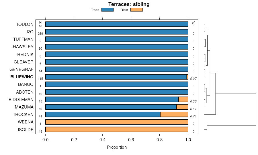
| Bluewing-Trocken families association, 5 to 15 percent slopes. | 115 | 2300 | 471531 | htnp | ca763 | 1984 | 1:24000 |
Bluewing-Izo complex, 5-15% slopes | 1002 | 681 | 3356321 | 2zzg5 | ca763 | 1984 | 1:24000 |
Trocken-Bluewing families complex, 15 to 30 percent slopes. | 178 | 124 | 471594 | htqq | ca763 | 1984 | 1:24000 |
Bluewing-Izo complex, 5-15% slopes | 1002 | 8276 | 3271051 | 2zzg5 | ca806 | | 1:24000 |
Bluewing gravelly sandy loam, 2 to 8 percent slopes | 105 | 459 | 1408866 | 1j919 | nv602 | 1985 | 1:24000 |
Bluewing-Toulon-Tuffman association | 7300 | 305 | 2439159 | 2mw4k | nv602 | 1985 | 1:24000 |
Mazuma-Bluewing-Woolsey association | 984 | 279 | 2450962 | 2n8f9 | nv602 | 1985 | 1:24000 |
Biddleman-Bluewing association | 7018 | 10008 | 2427741 | 2mh87 | nv603 | 1971 | 1:24000 |
Tuffman-Bluewing-Labou association | 7099 | 7123 | 2428392 | 2mhy7 | nv603 | 1971 | 1:24000 |
Trocken-Biddleman-Bluewing assciation | 7045 | 3659 | 2427771 | 2mh96 | nv603 | 1971 | 1:24000 |
Hawsley-Ruhe-Bluewing association | 7047 | 1563 | 2427773 | 2w4dm | nv603 | 1971 | 1:24000 |
Rawe-Bluewing-Trocken association | 7046 | 380 | 2427772 | 2mh97 | nv603 | 1971 | 1:24000 |
Bluewing gravelly loamy sand, 2 to 8 percent slopes | 117 | 361 | 643781 | plx4 | nv603 | 1971 | 1:24000 |
Bluewing very gravelly sandy loam, 2 to 8 percent slopes, occasionally flooded | 7019 | 206 | 2427742 | 2mh88 | nv603 | 1971 | 1:24000 |
Trocken-Hawsley-Bluewing association | 7051 | 71 | 2427774 | 2mh99 | nv603 | 1971 | 1:24000 |
Bluewing very gravelly loamy sand, 2 to 12 percent slopes | BuC | 3181 | 491502 | jhfx | nv611 | 1967 | 1:24000 |
Bluewing very gravelly sand, 0 to 8 percent slopes | BLC | 8697 | 495559 | jmns | nv622 | 1972 | 1:24000 |
Lathrop-Bluewing association | LF | 5748 | 495589 | jmpr | nv622 | 1972 | 1:24000 |
Bluewing gravelly loam, 0 to 4 percent slopes | BOB | 5145 | 495562 | jmnw | nv622 | 1972 | 1:24000 |
Orphant-Bluewing association | OS | 4708 | 495614 | jmqk | nv622 | 1972 | 1:24000 |
Bluewing very stony loamy sand, 2 to 8 percent slopes | BNC | 4356 | 495561 | jmnv | nv622 | 1972 | 1:24000 |
Bluewing gravelly loamy sand, 0 to 4 percent slopes | BMB | 3212 | 495560 | jmnt | nv622 | 1972 | 1:24000 |
Tybo-Bluewing association | TR | 1573 | 495656 | jmrx | nv622 | 1972 | 1:24000 |
Rawe-Bluewing-Trocken association | 7046 | 3269 | 2425524 | 2mdyq | nv625 | 1981 | 1:24000 |
Bluewing very gravelly sand, 2 to 8 percent slopes | 161 | 1745 | 473895 | hx3y | nv625 | 1981 | 1:24000 |
Perazzo-Rawe-Bluewing association | 7076 | 1485 | 2425523 | 2mdyp | nv625 | 1981 | 1:24000 |
Trocken-Bluewing association | 7065 | 1215 | 2425532 | 2mdyz | nv625 | 1981 | 1:24000 |
Cleaver-Trocken-Bluewing association | 214 | 817 | 474106 | 2xdmw | nv625 | 1981 | 1:24000 |
Bluewing-Hawsley association | 7075 | 782 | 2425567 | 2w4dr | nv625 | 1981 | 1:24000 |
Bluewing variant clay, 2 to 8 percent slopes | 151 | 685 | 473894 | hx3x | nv625 | 1981 | 1:24000 |
Perazzo-Bluewing association | 7068 | 415 | 2425520 | 2mdyl | nv625 | 1981 | 1:24000 |
Rednik-Trocken-Bluewing association | 7069 | 198 | 2425529 | 2w36k | nv625 | 1981 | 1:24000 |
Bluewing very stony loamy sand, 2 to 8 percent slopes | 162 | 197 | 473896 | hx3z | nv625 | 1981 | 1:24000 |
Tuffman-Bluewing-Labou association | 7099 | 33 | 2425573 | 2mf09 | nv625 | 1981 | 1:24000 |
Biddleman-Bluewing association | 7018 | 5 | 2452812 | 2nbbz | nv625 | 1981 | 1:24000 |
Hawsley-Ruhe-Bluewing association | 7047 | 15254 | 474176 | 2w4dm | nv628 | 1980 | 1:24000 |
Trocken-Ruhe-Bluewing association | 1361 | 2996 | 474185 | hxf9 | nv628 | 1980 | 1:24000 |
Trocken-Stumble-Bluewing association | 1360 | 2936 | 474184 | hxf8 | nv628 | 1980 | 1:24000 |
Trocken-Biddleman-Bluewing association | 7045 | 2546 | 2452475 | 2nb03 | nv628 | 1980 | 1:24000 |
Trocken-Tuffman-Bluewing association | 1368 | 1386 | 3014706 | 2whpg | nv628 | 1980 | 1:24000 |
Rawe-Bluewing-Trocken association | 7046 | 551 | 2452476 | 2nb04 | nv628 | 1980 | 1:24000 |
Trocken-Hawsley-Bluewing association | 7051 | 415 | 2452473 | 2nb01 | nv628 | 1980 | 1:24000 |
Stumble-Ruhe-Bluewing association | 1350 | 398 | 474181 | hxf5 | nv628 | 1980 | 1:24000 |
Hawsley-Bluewing association | 1347 | 263 | 474434 | 2rpfc | nv628 | 1980 | 1:24000 |
Bluewing gravelly sandy loam, 2 to 8 percent slopes | 160 | 24453 | 474690 | hxyl | nv760 | 1994 | 1:24000 |
Bluewing-Trocken association | 161 | 3860 | 474691 | hxym | nv760 | 1994 | 1:24000 |
Genegraf-Bluewing-Dorper association | 402 | 59984 | 476295 | hzmc | nv761 | 1988 | 1:24000 |
Bluewing-Toulon-Tuffman association | 7300 | 19219 | 2452928 | 2nbgq | nv761 | 1988 | 1:24000 |
Aboten-Jerval-Bluewing association | 110 | 17022 | 476228 | hzk6 | nv761 | 1988 | 1:24000 |
Bluewing gravelly sandy loam 2 to 8 percent slopes | 172 | 10505 | 476268 | hzlh | nv761 | 1988 | 1:24000 |
Aboten-Bluewing association | 114 | 7429 | 476233 | hzkc | nv761 | 1988 | 1:24000 |
Toulon-Appian-Bluewing association | 1080 | 6196 | 476227 | hzk5 | nv761 | 1988 | 1:24000 |
Woolsey-Bluewing association | 1190 | 2345 | 476236 | hzkg | nv761 | 1988 | 1:24000 |
Bluewing very gravelly loamy sand, 0 to 2 percent slopes, frequently flooded | 173 | 2005 | 476269 | hzlj | nv761 | 1988 | 1:24000 |
Hawsley-Bluewing association | 453 | 1125 | 476312 | 2rpfc | nv761 | 1988 | 1:24000 |
Genegraf-Dorper-Bluewing association | 401 | 937 | 476294 | hzmb | nv761 | 1988 | 1:24000 |
Toulon-Mazuma-Bluewing association | 241 | 19658 | 475248 | hyjl | nv769 | 1986 | 1:24000 |
Bluewing, moderately steep-Bluewing-Daick association | 1200 | 11986 | 475188 | hygn | nv769 | 1986 | 1:24000 |
Genegraf-Chilper-Bluewing association | 1121 | 11280 | 475181 | hygf | nv769 | 1986 | 1:24000 |
Trocken-Bluewing association | 823 | 7404 | 475317 | hylt | nv769 | 1986 | 1:24000 |
Jerval-Chilper-Bluewing association | 131 | 7184 | 475203 | hyh4 | nv769 | 1986 | 1:24000 |
Genegraf-Trocken-Bluewing association | 1122 | 6849 | 475182 | hygg | nv769 | 1986 | 1:24000 |
Mazuma-Bluewing-Woolsey association | 984 | 1998 | 475342 | hymm | nv769 | 1986 | 1:24000 |
Cleaver-Trocken-Bluewing association | 1130 | 1368 | 475184 | 2xdmw | nv769 | 1986 | 1:24000 |
Bluewing gravelly sandy loam, 2 to 8 percent slopes | 1201 | 340 | 475189 | hygp | nv769 | 1986 | 1:24000 |
Rednik-Trocken-Bluewing association | 310 | 26000 | 476531 | 2w36k | nv770 | 1995 | 1:24000 |
Genegraf-Trocken-Bluewing association | 1231 | 22265 | 476425 | hzrk | nv770 | 1995 | 1:24000 |
Trocken-Bluewing association | 283 | 22192 | 476518 | hzvk | nv770 | 1995 | 1:24000 |
Genegraf-Buckaroo-Bluewing association | 1233 | 19643 | 476427 | hzrm | nv770 | 1995 | 1:24000 |
Bluewing-Inmo association | 180 | 18477 | 476468 | hzsy | nv770 | 1995 | 1:24000 |
Buckaroo-Rednik-Bluewing association | 153 | 15010 | 476449 | hzsb | nv770 | 1995 | 1:24000 |
Bluewing-Pineval association | 184 | 13589 | 476471 | hzt1 | nv770 | 1995 | 1:24000 |
Buckaroo-Bluewing association | 150 | 13161 | 476446 | 2xdmv | nv770 | 1995 | 1:24000 |
Mazuma-Bluewing association | 643 | 12267 | 476637 | hzzd | nv770 | 1995 | 1:24000 |
Cleaver-Trocken-Bluewing association | 530 | 8369 | 476609 | 2xdmw | nv770 | 1995 | 1:24000 |
Ganaflan-Bluewing-Trocken association | 1071 | 7575 | 476397 | hzqn | nv770 | 1995 | 1:24000 |
Trocken-Bluewing-Trocken, saline-sodic association | 423 | 7212 | 476582 | hzxm | nv770 | 1995 | 1:24000 |
Bluewing-Toulon-Tuffman association | 7300 | 7104 | 2452938 | 2nbh1 | nv770 | 1995 | 1:24000 |
Bluewing-Hawsley association | 7075 | 5126 | 2425539 | 2w4dr | nv770 | 1995 | 1:24000 |
Aboten-Inmo-Bluewing association | 820 | 4987 | 476674 | j00l | nv770 | 1995 | 1:24000 |
Barnmot-Bluewing-Badland association | 610 | 4248 | 476630 | hzz5 | nv770 | 1995 | 1:24000 |
Bluewing very gravelly loamy sand, 2 to 8 percent slopes | 181 | 4210 | 476469 | hzsz | nv770 | 1995 | 1:24000 |
Hawsley-Celeton-Bluewing association | 147 | 3419 | 476445 | hzs6 | nv770 | 1995 | 1:24000 |
Biddleman-Bluewing-Trocken association | 216 | 2311 | 476498 | hztx | nv770 | 1995 | 1:24000 |
Pineval-Bluewing-Inmo association | 520 | 1924 | 476608 | hzyg | nv770 | 1995 | 1:24000 |
Tuffman-Bluewing-Labou association | 7099 | 1332 | 2452499 | 2nb0w | nv770 | 1995 | 1:24000 |
Genegraf-Bluewing-Dorper association | 1230 | 682 | 476424 | hzrj | nv770 | 1995 | 1:24000 |
Turupah-Parran association | 7024 | 233 | 2453033 | 2nbl3 | nv770 | 1995 | 1:24000 |
Biddleman-Bluewing association | 7018 | 139 | 2452496 | 2nb0s | nv770 | 1995 | 1:24000 |
Rawe-Bluewing-Trocken association | 7046 | 94 | 2425527 | 2mdyt | nv770 | 1995 | 1:24000 |
Trocken-Bluewing association | 1061 | 6578 | 477287 | j0nc | nv771 | 1990 | 1:24000 |
Trocken-Ganaflan-Bluewing association, dry | 1063 | 5108 | 477289 | j0nf | nv771 | 1990 | 1:24000 |
Trocken-Ganaflan-Bluewing association | 1580 | 4109 | 477394 | j0rt | nv771 | 1990 | 1:24000 |
Trocken-Ruhe-Bluewing association | 1065 | 3742 | 477291 | j0nh | nv771 | 1990 | 1:24000 |
Bluewing-Trocken association | 1043 | 893 | 477284 | j0n8 | nv771 | 1990 | 1:24000 |
Rednik-Trocken-Bluewing association | 3072 | 20247 | 2425528 | 2w36k | nv774 | 1985 | 1:24000 |
Trocken-Bluewing association | 1210 | 10222 | 476736 | j02l | nv774 | 1985 | 1:24000 |
Deefan-Rawe-Bluewing association | 3040 | 8726 | 476881 | j078 | nv774 | 1985 | 1:24000 |
Perazzo-Rawe-Bluewing association | 3001 | 6774 | 476874 | j071 | nv774 | 1985 | 1:24000 |
Deefan-Cleaver-Bluewing association | 3043 | 3848 | 476883 | j07b | nv774 | 1985 | 1:24000 |
Rawe-Bluewing-Trocken association | 3020 | 3577 | 476879 | j076 | nv774 | 1985 | 1:24000 |
Luning-Hawsley-Bluewing association | 1875 | 3106 | 476822 | j05c | nv774 | 1985 | 1:24000 |
Singatse-Gynelle-Bluewing association | 1091 | 2706 | 476710 | j01r | nv774 | 1985 | 1:24000 |
Tuffman-Bluewing-Jacaranda association | 7105 | 2464 | 2425606 | 2mf1c | nv774 | 1985 | 1:24000 |
Perazzo-Bluewing association | 3003 | 1950 | 476876 | j073 | nv774 | 1985 | 1:24000 |
Bluewing, occasionally flooded-Trocken association | 7093 | 1698 | 2425598 | 2mf13 | nv774 | 1985 | 1:24000 |
Bluewing very gravelly loamy sand, 2 to 8 percent slopes | 7014 | 1527 | 2425469 | 2mdwy | nv774 | 1985 | 1:24000 |
Tuffman-Bluewing-Labou association | 7099 | 1063 | 2425604 | 2mf19 | nv774 | 1985 | 1:24000 |
Hawsley-Bluewing association | 7080 | 623 | 2425591 | 2rpfc | nv774 | 1985 | 1:24000 |
Buckaroo-Bluewing association | 1180 | 554 | 476730 | 2xdmv | nv774 | 1985 | 1:24000 |
Cleaver-Trocken-Bluewing association | 7059 | 245 | 2425472 | 2xdmw | nv774 | 1985 | 1:24000 |
Bluewing-Hawsley association | 7075 | 168 | 2425590 | 2w4dr | nv774 | 1985 | 1:24000 |
Beoska-Bluewing association | 141 | 3809 | 475516 | hyt7 | nv777 | 1993 | 1:24000 |
Luning-Hawsley-Bluewing association | 2110 | 4179 | 480845 | j4c4 | nv781 | 1994 | 1:24000 |
Bluewing very cobbly loam, 3 to 10 percent slopes, eroded | BLC2 | 3075 | 482384 | j5ys | ut632 | 1970 | 1:20000 |
