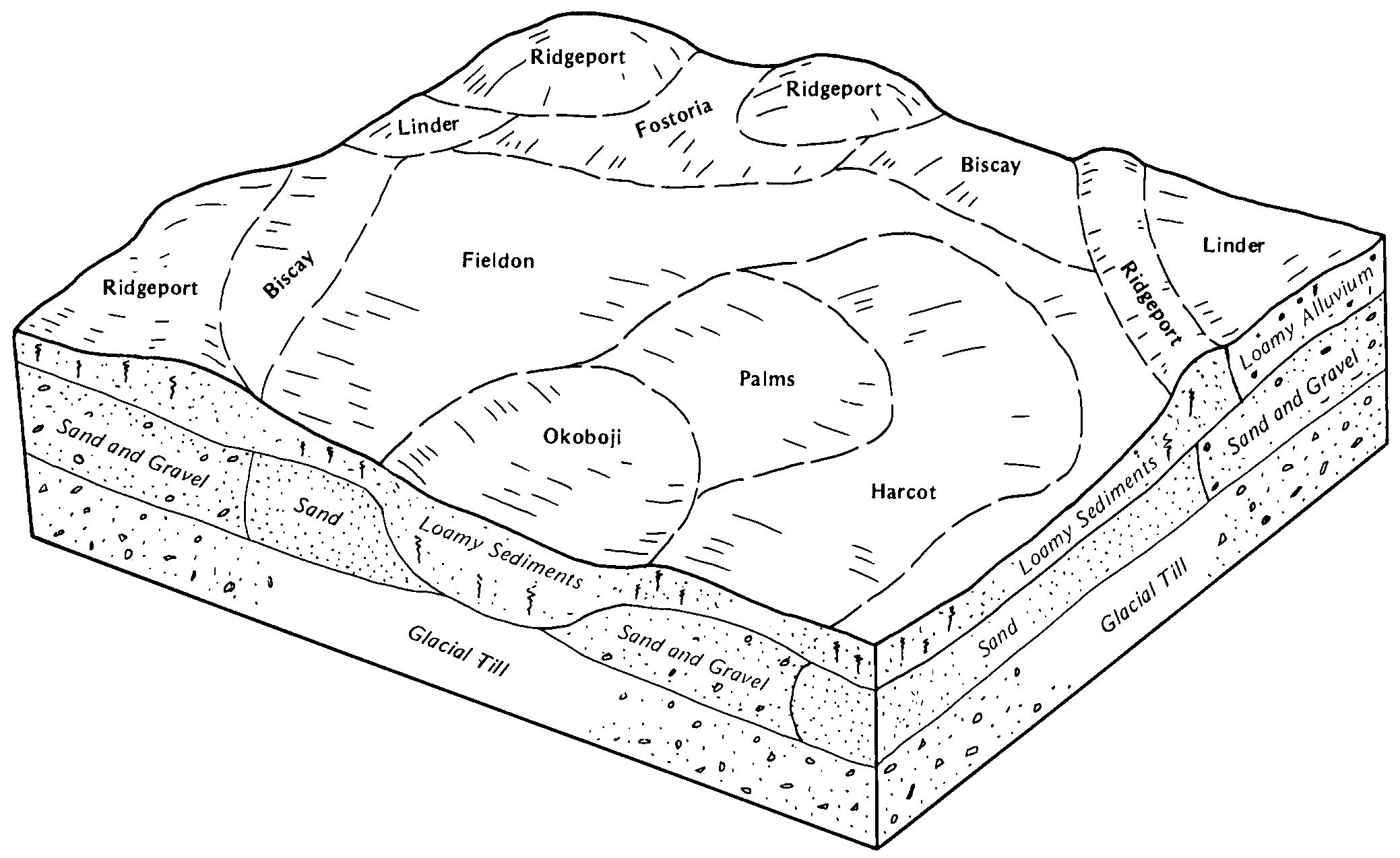
| Biscay clay loam, 0 to 2 percent slopes | 259 | 1117 | 2550252 | 2tsjc | ia015 | 1977 | 1:15840 |
Biscay clay loam, 0 to 2 percent slopes | 259 | 902 | 403286 | 2tsjc | ia021 | 1973 | 1:15840 |
Biscay clay loam, 0 to 2 percent slopes | 259 | 730 | 403468 | 2tsjc | ia025 | 1979 | 1:15840 |
Biscay clay loam, 0 to 2 percent slopes | 259 | 476 | 403524 | 2tsjc | ia027 | 1979 | 1:15840 |
Biscay clay loam, 0 to 2 percent slopes | 259 | 8020 | 399318 | 2tsjc | ia041 | 2002 | 1:12000 |
Biscay clay loam, depressional, 0 to 1 percent slopes | 1259 | 794 | 399272 | 2tsjb | ia041 | 2002 | 1:12000 |
Biscay clay loam, 0 to 2 percent slopes | 259 | 2359 | 404587 | 2tsjc | ia049 | 1980 | 1:15840 |
Biscay clay loam, 0 to 2 percent slopes | 259 | 788 | 2495322 | 2tsjc | ia059 | 2011 | 1:12000 |
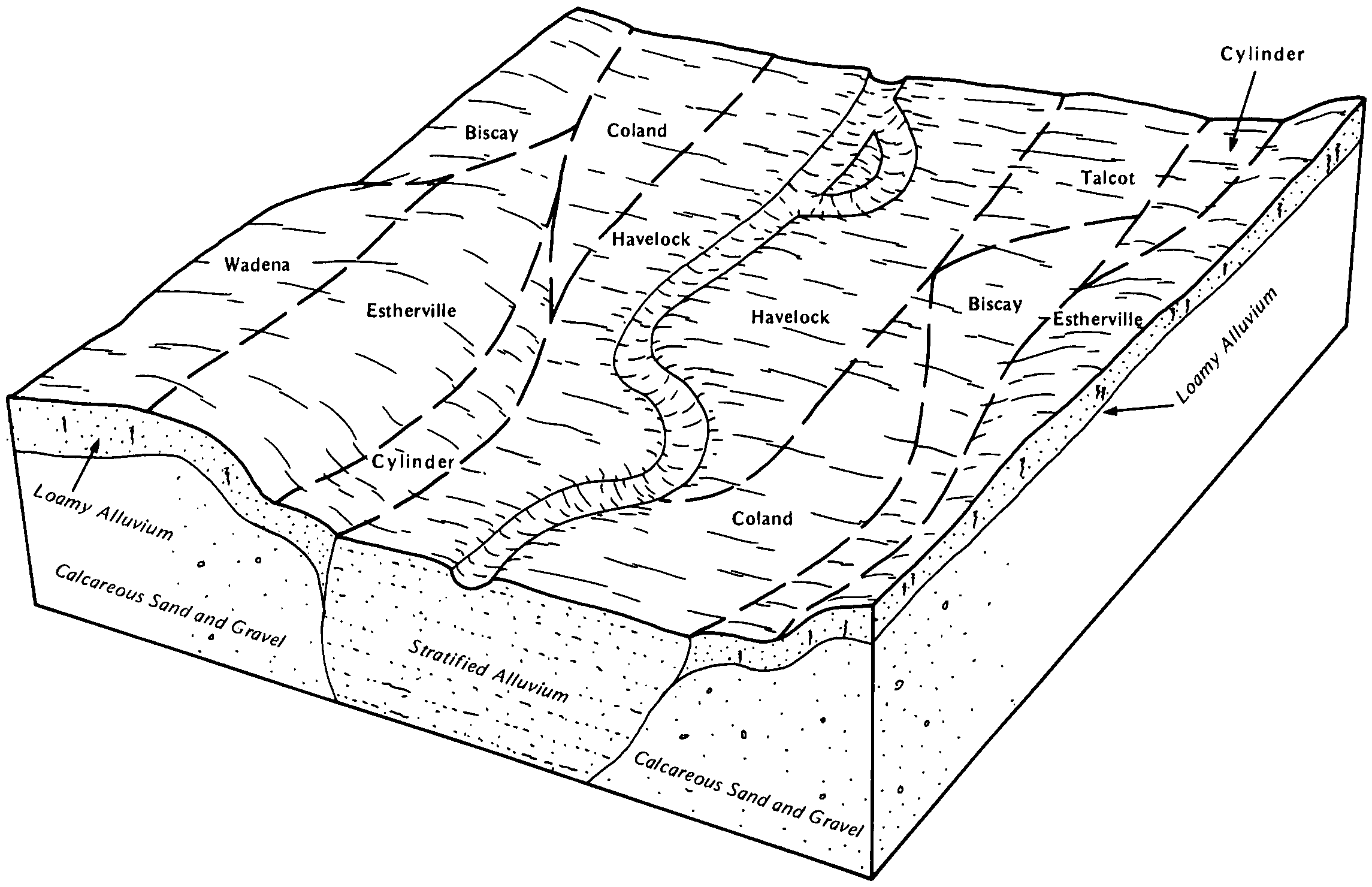
Talcot-Biscay complex, 0 to 2 percent slopes | 557 | 130 | 2481225 | 2p8xj | ia059 | 2011 | 1:12000 |
Biscay clay loam, 0 to 2 percent slopes | 259 | 563 | 405542 | 2tsjc | ia063 | 1989 | 1:15840 |
Biscay clay loam, 0 to 2 percent slopes | 259 | 2310 | 406214 | 2tsjc | ia073 | 1983 | 1:15840 |
Biscay clay loam, 0 to 2 percent slopes | 259 | 834 | 406474 | 2tsjc | ia079 | 1984 | 1:15840 |
Biscay clay loam, 0 to 2 percent slopes | 259 | 3626 | 406540 | 2tsjc | ia081 | 1987 | 1:15840 |
Biscay clay loam, depressional, 0 to 1 percent slopes | 1259 | 1255 | 406520 | 2tsjb | ia081 | 1987 | 1:15840 |
Biscay clay loam, 0 to 2 percent slopes | 259 | 1469 | 447533 | 2tsjc | ia091 | 1998 | 1:12000 |
Biscay clay loam, 0 to 2 percent slopes | 259 | 1898 | 408357 | 2tsjc | ia109 | 1980 | 1:15840 |
Biscay clay loam, deep, 0 to 2 percent slopes | 259 | 377 | 409083 | fqp7 | ia119 | 1973 | 1:15840 |
Biscay clay loam, 32 to 40 inches to sand and gravel, 0 to 2 percent slopes | 259 | 684 | 410062 | frpt | ia141 | 1977 | 1:15840 |
Biscay clay loam, 0 to 2 percent slopes | 259 | 1457 | 2506572 | 2tsjc | ia143 | 1985 | 1:15840 |
Talcot-Biscay complex, 0 to 2 percent slopes | 557 | 99 | 2506565 | 2q4mb | ia143 | 1985 | 1:15840 |
Biscay clay loam, 0 to 2 percent slopes | 259 | 4480 | 410268 | 2tsjc | ia147 | 1973 | 1:15840 |
Biscay clay loam, 0 to 2 percent slopes | 259 | 2988 | 410383 | 2tsjc | ia151 | 1982 | 1:15840 |
Biscay clay loam, 0 to 2 percent slopes | 259 | 2776 | 412882 | 2tsjc | ia153 | 1993 | 1:12000 |
Biscay clay loam, 0 to 2 percent slopes | 259 | 816 | 410784 | 2tsjc | ia161 | 1975 | 1:15840 |
Biscay loam, 32 to 40 inches to sand and gravel, 0 to 2 percent | 259 | 545 | 411201 | fswk | ia167 | 1987 | 1:15840 |
Biscay clay loam, 0 to 2 percent slopes | 259 | 1110 | 411305 | 2tsjc | ia169 | 1981 | 1:15840 |
Biscay clay loam, loamy substratum, 0 to 2 percent slopes | 278 | 911 | 1651355 | 1sfcj | ia187 | 2006 | 1:12000 |
Biscay clay loam, 0 to 2 percent slopes | 259 | 629 | 797941 | 2tsjc | ia187 | 2006 | 1:12000 |
Biscay clay loam, depressional, 0 to 1 percent slopes | 1259 | 129 | 1612301 | 2tsjb | ia187 | 2006 | 1:12000 |
Biscay clay loam, 0 to 2 percent slopes | 259 | 3397 | 412675 | 2tsjc | ia197 | 1988 | 1:15840 |
Biscay clay loam, 0 to 2 percent slopes | BY | 1526 | 396399 | 2tsjc | mn019 | 1987 | 1:12000 |
Biscay clay loam, 0 to 2 percent slopes | L6A | 1572 | 2421609 | 2tsjc | mn033 | 2008 | 1:12000 |
Biscay clay loam, loamy substratum, 0 to 2 percent slopes | L230A | 688 | 1720691 | 1vrj5 | mn033 | 2008 | 1:12000 |
Biscay clay loam, depressional, 0 to 1 percent slopes | L7A | 32 | 1727602 | 2tsjb | mn033 | 2008 | 1:12000 |
Biscay clay loam, 0 to 2 percent slopes | 392 | 424 | 397116 | 2tsjc | mn043 | 1989 | 1:20000 |
Biscay clay loam, 0 to 2 percent slopes | 392 | 6152 | 397860 | 2tsjc | mn047 | 1977 | 1:15840 |
Biscay clay loam, 0 to 2 percent slopes | L6A | 465 | 451624 | 2tsjc | mn053 | 2001 | 1:12000 |
Medo, Dassel and Biscay soils, ponded, 0 to 1 percent slopes | L31A | 246 | 451580 | 301v5 | mn053 | 2001 | 1:12000 |
Biscay clay loam, depressional, 0 to 1 percent slopes | L7A | 73 | 451623 | 2tsjb | mn053 | 2001 | 1:12000 |
Biscay clay loam, 0 to 2 percent slopes | 392 | 1248 | 398510 | 2tsjc | mn063 | 1984 | 1:20000 |
Biscay clay loam, depressional, 0 to 1 percent slopes | 399 | 3452 | 398688 | 2tsjb | mn067 | 1983 | 1:20000 |
Biscay-Palms complex | 1908 | 1286 | 398678 | fcvl | mn067 | 1983 | 1:20000 |
Biscay loam | 392 | 1176 | 398687 | fcvw | mn067 | 1983 | 1:20000 |
Biscay clay loam, 0 to 2 percent slopes | L6A | 641 | 2835077 | 2tsjc | mn067 | 1983 | 1:20000 |
Biscay clay loam, 0 to 2 percent slopes | 392 | 1072 | 398956 | 2tsjc | mn079 | 1986 | 1:20000 |
Biscay clay loam, 0 to 2 percent slopes | 392 | 1780 | 399168 | 2tsjc | mn085 | 1993 | 1:20000 |
Biscay clay loam, 0 to 2 percent slopes | 392 | 1399 | 400050 | 2tsjc | mn091 | 1985 | 1:20000 |
Mayer-Biscay, depressional complex, 0 to 2 percent slopes | 1097 | 4861 | 436177 | gmw7 | mn093 | 1996 | 1:20000 |
Medo, Dassel and Biscay soils, ponded, 0 to 1 percent slopes | 1406 | 4386 | 436235 | 301v5 | mn093 | 1996 | 1:20000 |
Biscay clay loam, 0 to 2 percent slopes | 1098 | 3439 | 436178 | 2tsjc | mn093 | 1996 | 1:20000 |
Biscay clay loam, depressional, 0 to 1 percent slopes | 399 | 351 | 436365 | 2tsjb | mn093 | 1996 | 1:20000 |
Biscay clay loam, 0 to 2 percent slopes | 392 | 970 | 1859447 | 2tsjc | mn101 | 2008 | 1:12000 |
Biscay silty clay loam, 0 to 2 percent slopes, occasionally flooded | P3A | 7 | 1652611 | 1sgp1 | mn101 | 2008 | 1:12000 |
Biscay silty clay loam, 0 to 2 percent slopes, occasionally flooded | P3A | 5533 | 630076 | p4n1 | mn105 | 2004 | 1:12000 |
Biscay clay loam, 0 to 2 percent slopes | L6A | 343 | 806455 | 2tsjc | mn105 | 2004 | 1:12000 |
Biscay clay loam, 0 to 2 percent slopes | 392 | 1670 | 2374035 | 2tsjc | mn127 | 2008 | 1:12000 |
Biscay clay loam, depressional, 0 to 1 percent slopes | 399 | 1556 | 2374036 | 2tsjb | mn127 | 2008 | 1:12000 |
Biscay clay loam, 0 to 2 percent slopes | 392 | 1232 | 436093 | 2tsjc | mn129 | 1995 | 1:20000 |
Biscay clay loam, 0 to 2 percent slopes | 392 | 1638 | 429655 | 2tsjc | mn131 | 1996 | 1:12000 |
Biscay silty clay loam, 0 to 2 percent slopes, occasionally flooded | P3A | 251 | 432702 | gj84 | mn133 | 2002 | 1:12000 |
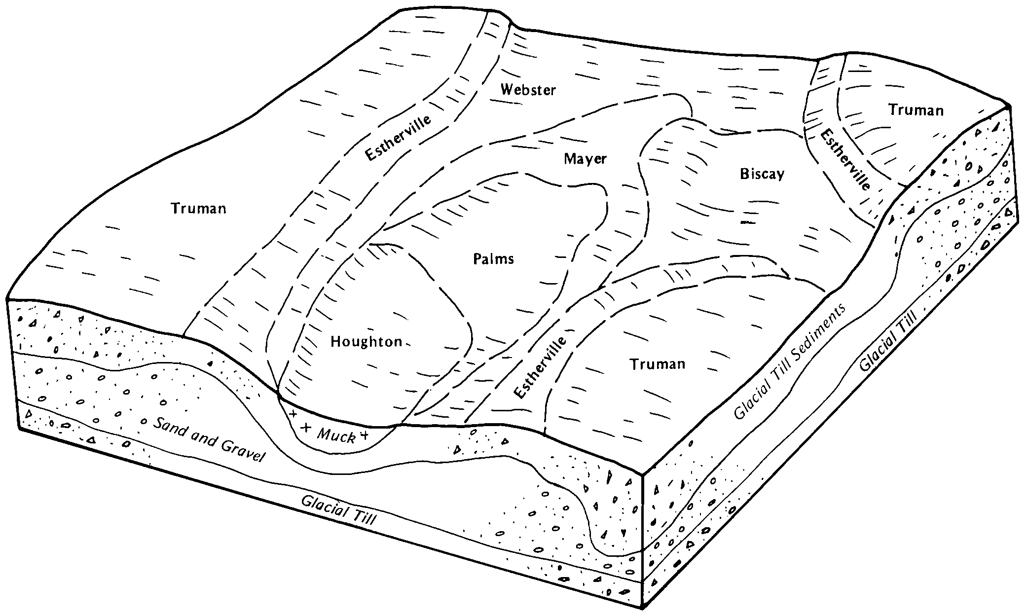
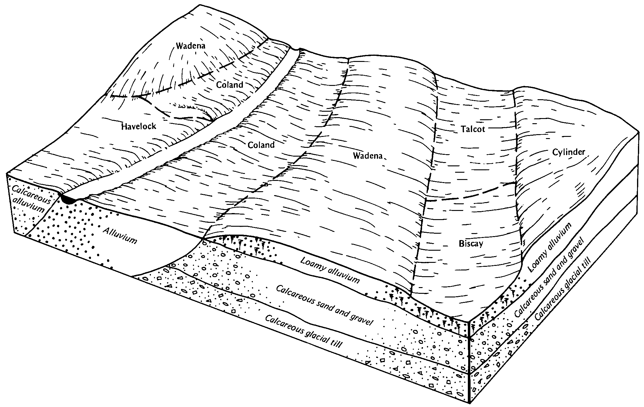
Webster-Biscay complex | 1093 | 661 | 431514 | gh0t | mn143 | 1991 | 1:20000 |
Biscay loam | 392 | 4292 | 428132 | gchq | mn145 | 1980 | 1:15840 |
Biscay loam, depressional | 399 | 1574 | 428133 | gchr | mn145 | 1980 | 1:15840 |
Biscay clay loam, 0 to 2 percent slopes | L6A | 318 | 2835078 | 2tsjc | mn145 | 1980 | 1:15840 |
Biscay clay loam, 0 to 2 percent slopes | Bc | 3475 | 428196 | 2tsjc | mn147 | 1967 | 1:20000 |
Biscay clay loam, depressional, 0 to 1 percent slopes | Bd | 1005 | 428197 | 2tsjb | mn147 | 1967 | 1:20000 |
Biscay silty clay loam | Be | 1064 | 428316 | gcpn | mn149 | 1966 | 1:15840 |
Biscay silty clay loam, depressional | Bf | 760 | 428317 | gcpp | mn149 | 1966 | 1:15840 |
Biscay clay loam, 0 to 2 percent slopes | 392 | 294 | 428947 | 2tsjc | mn165 | 1987 | 1:20000 |
Biscay clay loam, 0 to 2 percent slopes | 392 | 942 | 433732 | 2tsjc | mn171 | 1998 | 1:12000 |
Medo, Dassel and Biscay soils, ponded, 0 to 1 percent slopes | 1406 | 274 | 435064 | 301v5 | mn171 | 1998 | 1:12000 |
