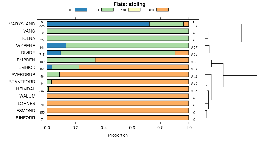
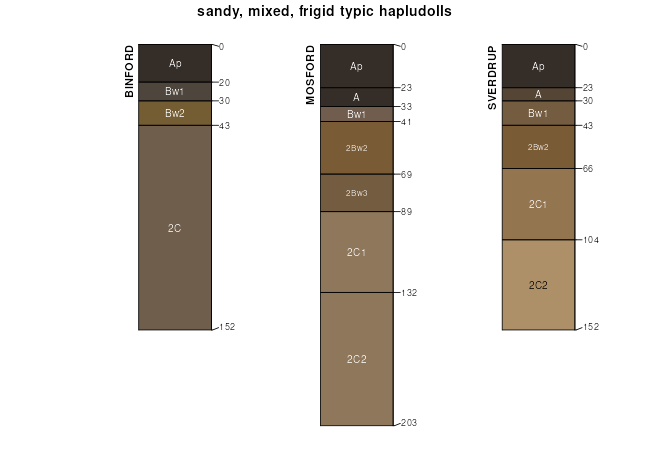
| Binford-Coe complex, 0 to 2 percent slopes | G304A | 10 | 2573604 | 2q4zc | nd003 | 1988 | 1:20000 |
Coe-Binford complex, 6 to 9 perent slopes | G304C | 6243 | 2573701 | 2q4zf | nd005 | | 1:12000 |
Coe-Binford sandy loams, 9 to 25 percent slopes | G304E | 5801 | 2573733 | 2q4zg | nd005 | | 1:12000 |
Coe-Binford sandy loams, 9 to 25 percent slopes | F304E | 1611 | 2587736 | 2q4vl | nd005 | | 1:12000 |
Coe-Binford complex, 6 to 9 percent slopes | F304C | 957 | 2587680 | 2q4vk | nd005 | | 1:12000 |
Binford-Coe complex, 0 to 2 percent slopes | G304A | 856 | 2573726 | 2q4zc | nd005 | | 1:12000 |
Binford-Coe complex, 2 to 6 percent slopes | G304B | 435 | 2573728 | 2q619 | nd005 | | 1:12000 |
Binford-Coe complex, 0 to 2 percent slopes | F304A | 43 | 2587633 | 2q61w | nd005 | | 1:12000 |
Binford-Coe complex, 2 to 6 percent slopes | F304B | 29 | 2587658 | 2q4vj | nd005 | | 1:12000 |
Binford sandy loam, 2 to 6 percent slopes | I659B | 622 | 2643075 | 2pgf8 | nd019 | 1987 | 1:20000 |
Binford sandy loam, 6 to 9 percent slopes | I659C | 437 | 2643078 | 2pgf9 | nd019 | 1987 | 1:20000 |
Binford sandy loam, 0 to 2 percent slopes | I659A | 120 | 2643094 | 2pgf7 | nd019 | 1987 | 1:20000 |
Coe-Binford complex, 6 to 9 percent slopes | F304C | 74 | 2587554 | 2q4vk | nd019 | 1987 | 1:20000 |
Binford-Coe complex, 2 to 6 percent slopes | F304B | 34 | 2587553 | 2q4vj | nd019 | 1987 | 1:20000 |
Binford-Coe complex, 0 to 2 percent slopes | F304A | 13 | 2587591 | 2q61w | nd019 | 1987 | 1:20000 |
Coe-Binford complex, 6 to 9 perent slopes | G304C | 968 | 2575306 | 2q4zf | nd021 | 1989 | 1:20000 |
Binford-Coe complex, 2 to 6 percent slopes | G304B | 279 | 2575381 | 2q619 | nd021 | 1989 | 1:20000 |
Binford-Coe complex, 0 to 2 percent slopes | G304A | 51 | 2575305 | 2q4zc | nd021 | 1989 | 1:20000 |
Coe-Binford sandy loams, 9 to 25 percent slopes | G304E | 4 | 2575307 | 2q4zg | nd021 | 1989 | 1:20000 |
Binford-Coe complex, 2 to 6 percent slopes | G304B | 6867 | 2576359 | 2q619 | nd027 | | 1:12000 |
Binford-Coe complex, 0 to 2 percent slopes | G304A | 3802 | 2576274 | 2q4zc | nd027 | | 1:12000 |
Coe-Binford complex, 6 to 9 perent slopes | G304C | 3516 | 2576275 | 2q4zf | nd027 | | 1:12000 |
Coe-Binford sandy loams, 9 to 25 percent slopes | G304E | 2979 | 2576276 | 2q4zg | nd027 | | 1:12000 |
Binford-Coe complex, 0 to 2 percent slopes | G304A | 22179 | 2576616 | 2q4zc | nd039 | 1991 | 1:24000 |
Binford-Coe complex, 2 to 6 percent slopes | G304B | 9195 | 2576682 | 2q619 | nd039 | 1991 | 1:24000 |
Coe-Binford complex, 6 to 9 perent slopes | G304C | 5719 | 2576617 | 2q4zf | nd039 | 1991 | 1:24000 |
Coe-Binford sandy loams, 9 to 25 percent slopes | G304E | 4806 | 2576618 | 2q4zg | nd039 | 1991 | 1:24000 |
Binford-Coe complex, 0 to 2 percent slopes | G304A | 4201 | 2577302 | 2q4zc | nd063 | | 1:12000 |
Coe-Binford sandy loams, 9 to 25 percent slopes | G304E | 2087 | 2577304 | 2q4zg | nd063 | | 1:12000 |
Coe-Binford complex, 6 to 9 perent slopes | G304C | 839 | 2577303 | 2q4zf | nd063 | | 1:12000 |
Binford-Coe complex, 2 to 6 percent slopes | G304B | 248 | 2577384 | 2q619 | nd063 | | 1:12000 |
Coe-Binford sandy loams, 9 to 25 percent slopes | F304E | 27 | 2587365 | 2q4vl | nd063 | | 1:12000 |
Binford sandy loam, 0 to 2 percent slopes | I659A | 2844 | 2643035 | 2pgf7 | nd067 | 1972 | 1:20000 |
Binford sandy loam, 2 to 6 percent slopes | I659B | 772 | 2643036 | 2pgf8 | nd067 | 1972 | 1:20000 |
Coe-Binford complex, 6 to 25 percent slopes | I595E | 165 | 2643005 | 2pywd | nd067 | 1972 | 1:20000 |
Binford-Coe complex, 2 to 6 percent slopes | F304B | 187 | 2587119 | 2q4vj | nd071 | 1984 | 1:12000 |
Coe-Binford complex, 6 to 9 percent slopes | F304C | 8 | 2587120 | 2q4vk | nd071 | 1984 | 1:12000 |
Binford-Coe complex, 0 to 2 percent slopes | F304A | 3 | 2587165 | 2q61w | nd071 | 1984 | 1:12000 |
Binford-Coe complex, 0 to 2 percent slopes | G304A | 76 | 2581159 | 2q4zc | nd073 | 1992 | 1:20000 |
Binford-Coe complex, 2 to 6 percent slopes | G304B | 56 | 2581221 | 2q619 | nd073 | 1992 | 1:20000 |
Binford-Coe complex, 0 to 2 percent slopes | G304A | 6701 | 2579751 | 2q4zc | nd091 | 1991 | 1:20000 |
Coe-Binford complex, 6 to 9 perent slopes | G304C | 2520 | 2579752 | 2q4zf | nd091 | 1991 | 1:20000 |
Binford-Coe complex, 2 to 6 percent slopes | G304B | 2450 | 2579789 | 2q619 | nd091 | 1991 | 1:20000 |
Binford-Coe complex, 0 to 6 percent slopes | I595B | 447 | 2641430 | 2pyx2 | nd091 | 1991 | 1:20000 |
Coe-Binford sandy loams, 9 to 25 percent slopes | G304E | 286 | 2579753 | 2q4zg | nd091 | 1991 | 1:20000 |
Coe-Binford complex, 6 to 25 percent slopes | I595E | 80 | 2641411 | 2pywd | nd091 | 1991 | 1:20000 |
Coe-Binford sandy loams, 9 to 25 percent slopes | F304E | 1106 | 2587058 | 2q4vl | nd095 | 1992 | 1:24000 |
Coe-Binford complex, 6 to 9 percent slopes | F304C | 774 | 2587031 | 2q4vk | nd095 | 1992 | 1:24000 |
Binford-Coe complex, 2 to 6 percent slopes | F304B | 718 | 2586225 | 2q4vj | nd095 | 1992 | 1:24000 |
Binford-Coe complex, 0 to 2 percent slopes | F304A | 158 | 2586211 | 2q61w | nd095 | 1992 | 1:24000 |
Coe-Binford complex, 6 to 9 percent slopes | F304C | 264 | 2586147 | 2q4vk | nd099 | 1967 | 1:20000 |
Coe-Binford sandy loams, 9 to 25 percent slopes | F304E | 87 | 2586148 | 2q4vl | nd099 | 1967 | 1:20000 |
Binford-Coe complex, 2 to 6 percent slopes | F304B | 70 | 2586146 | 2q4vj | nd099 | 1967 | 1:20000 |
Binford-Coe complex, 0 to 2 percent slopes | F304A | 36 | 2586189 | 2q61w | nd099 | 1967 | 1:20000 |


