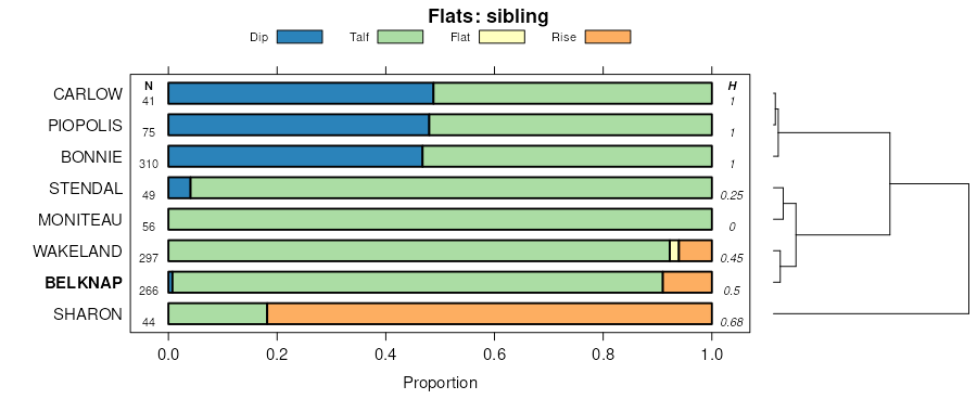
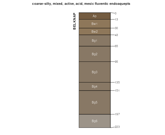
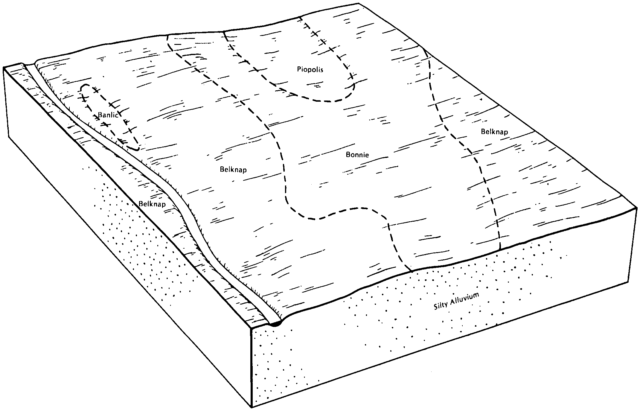
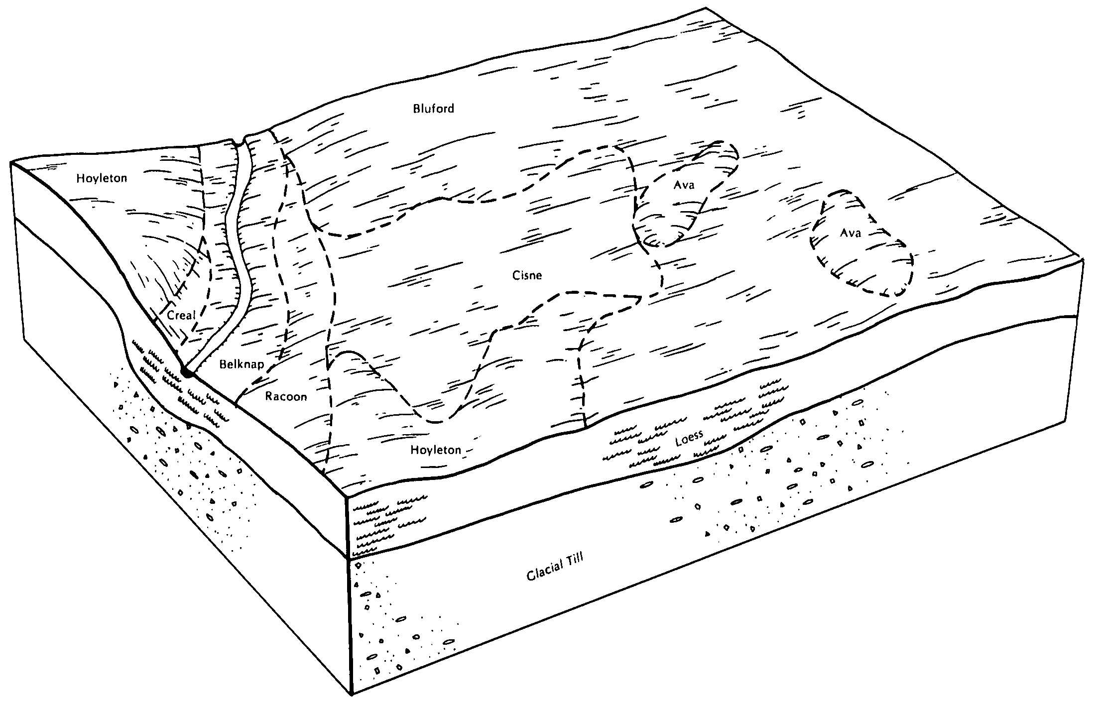
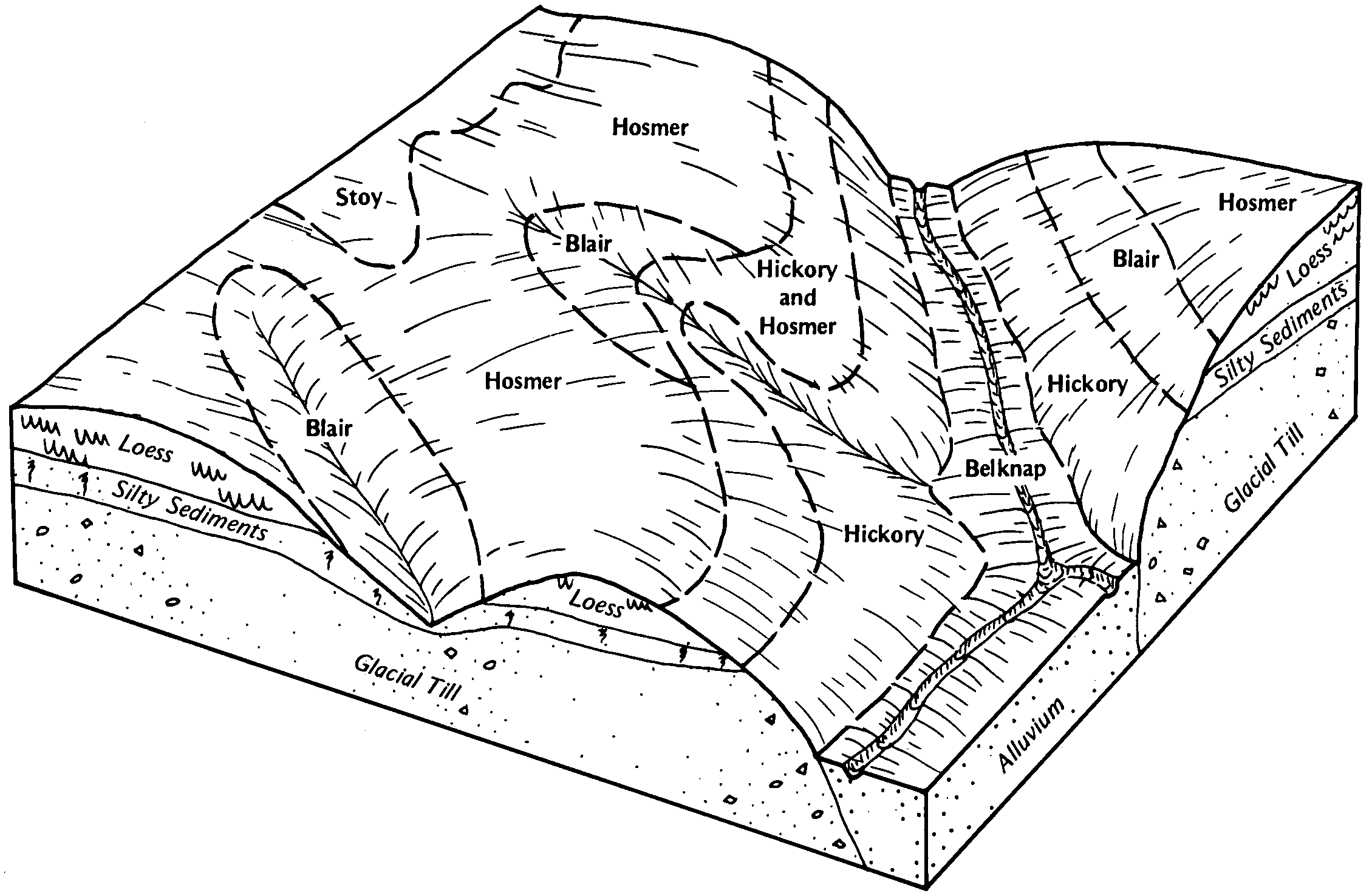
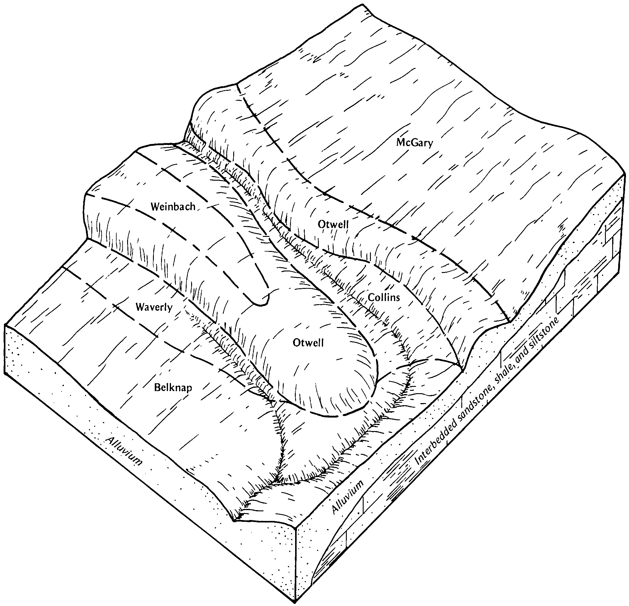
| Belknap silt loam, 0 to 2 percent slopes, occasionally flooded | 8382A | 2583 | 602275 | 2s2cn | il003 | 2002 | 1:12000 |
Belknap silt loam, 0 to 2 percent slopes, frequently flooded | 3382A | 127 | 602274 | n6q6 | il003 | 2002 | 1:12000 |
Belknap silt loam, 0 to 2 percent slopes, frequently flooded | 3382A | 5100 | 2109210 | 2tbrv | il025 | 1993 | 1:12000 |
Belknap silt loam, 0 to 2 percent slopes, frequently flooded | 3382A | 20049 | 175468 | 2tbrv | il047 | 1967 | 1:15840 |
Belknap silt loam, 0 to 2 percent slopes, frequently flooded | 3382A | 26202 | 809253 | 2tbrv | il055 | 2005 | 1:12000 |
Belknap silt loam, 0 to 2 percent slopes, frequently flooded | 3382A | 3079 | 211660 | 2tbrv | il059 | 1966 | 1:20000 |
Belknap silt loam, 0 to 2 percent slopes, occasionally flooded | 8382A | 35840 | 175137 | 2tbs9 | il065 | 1982 | 1:15840 |
Belknap silt loam, 0 to 2 percent slopes, occasionally flooded | 8382A | 2642 | 714046 | 2s2cn | il069 | 2003 | 1:12000 |
Belknap silt loam, 0 to 2 percent slopes, frequently flooded | 3382A | 698 | 713991 | ryyz | il069 | 2003 | 1:12000 |
Belknap silt loam, 0 to 2 percent slopes, frequently flooded | 3382A | 5733 | 1537877 | 2tbrv | il077 | 2006 | 1:12000 |
Belknap silt loam, 0 to 2 percent slopes, occasionally flooded | 8382A | 4604 | 1538091 | 2tbs9 | il077 | 2006 | 1:12000 |
Belknap silt loam, 0 to 2 percent slopes, frequently flooded | 3382A | 34757 | 1540503 | 2tbrv | il081 | 2005 | 1:12000 |
Belknap silt loam, 0 to 2 percent slopes, occasionally flooded | 8382A | 12860 | 1603720 | 2s2cn | il087 | 2005 | 1:12000 |
Belknap silt loam, 0 to 2 percent slopes, frequently flooded | 3382A | 3537 | 1146230 | 17gr5 | il087 | 2005 | 1:12000 |
Belknap silt loam, 0 to 2 percent slopes, occasionally flooded | 8382A | 15314 | 176768 | 2tbs9 | il101 | 1952 | 1:42240 |
Belknap silt loam, 0 to 2 percent slopes, frequently flooded | 3382A | 5779 | 2027426 | 2tbrv | il121 | 2008 | 1:12000 |
Belknap silt loam, 0 to 2 percent slopes, occasionally flooded | 8382A | 16813 | 808144 | 2s2cn | il127 | 2004 | 1:12000 |
Belknap silt loam, 0 to 2 percent slopes, frequently flooded, long duration | 3382L | 474 | 808089 | w3wd | il127 | 2004 | 1:12000 |
Belknap silt loam, 0 to 2 percent slopes, frequently flooded | 3382A | 317 | 808088 | w3wc | il127 | 2004 | 1:12000 |
Belknap silt loam, 0 to 2 percent slopes, frequently flooded | 3382A | 15947 | 1405916 | 2tbrv | il145 | 2005 | 1:12000 |
Belknap silt loam, 0 to 2 percent slopes, occasionally flooded | 8382A | 9654 | 608062 | 2s2cn | il151 | 2003 | 1:12000 |
Belknap silt loam, 0 to 2 percent slopes, frequently flooded, long duration | 3382L | 198 | 789689 | vhqv | il151 | 2003 | 1:12000 |
Belknap silt loam, 0 to 2 percent slopes, frequently flooded | 3382A | 22 | 608061 | ndqw | il151 | 2003 | 1:12000 |
Belknap silt loam, 0 to 2 percent slopes, occasionally flooded | 8382A | 9710 | 749029 | 2s2cn | il153 | 2004 | 1:12000 |
Belknap silt loam, 0 to 2 percent slopes, frequently flooded | 3382A | 1363 | 748962 | t4c2 | il153 | 2004 | 1:12000 |
Belknap silt loam, 0 to 2 percent slopes, frequently flooded | 3382A | 18679 | 2026864 | 2tbrv | il159 | 1967 | 1:12000 |
Belknap silt loam, 0 to 2 percent slopes, occasionally flooded | 8382A | 21110 | 178882 | 2tbs9 | il165 | 1974 | 1:15840 |
Belknap silt loam, 0 to 2 percent slopes, frequently flooded | 3382A | 9055 | 179688 | 2tbrv | il185 | 1962 | 1:20000 |
Belknap silt loam, 2 to 4 percent slopes, frequently flooded | 3382B | 315 | 179689 | 60zf | il185 | 1962 | 1:20000 |
Belknap silt loam, 0 to 2 percent slopes, frequently flooded | 3382A | 81 | 1528984 | 2tbrv | il189 | 2006 | 1:12000 |
Belknap silt loam, 0 to 2 percent slopes, frequently flooded | 3382A | 14134 | 2025098 | 2tbrv | il191 | 2008 | 1:12000 |
Belknap silt loam, 0 to 2 percent slopes, occasionally flooded | 8382A | 10475 | 2025118 | 2tbs9 | il191 | 2008 | 1:12000 |
Belknap silt loam, 0 to 2 percent slopes, frequently flooded | 3382A | 16715 | 1543943 | 2tbrv | il193 | 2006 | 1:12000 |
Belknap silt loam, 0 to 2 percent slopes, frequently flooded | 3382A | 28672 | 1478122 | 2tbrv | il199 | 2007 | 1:12000 |
Belknap silt loam, 0 to 2 percent slopes, occasionally flooded | 8382A | 627 | 1678575 | 2tbs9 | il199 | 2007 | 1:12000 |
Belknap silt loam, 0 to 2 percent slopes, frequently flooded, very brief duration | BdxAV | 4224 | 165898 | 5kmk | in119 | 1997 | 1:12000 |
Belknap silt loam, 0 to 2 percent slopes, frequently flooded | Bg | 16722 | 161892 | 2tbrv | in125 | 1983 | 1:15840 |
Belknap silt loam, rarely flooded | Bf | 2674 | 161891 | 5fg9 | in125 | 1983 | 1:15840 |
Belknap silt loam, 0 to 2 percent slopes, occasionally flooded | uBelA | 9882 | 2583894 | 2s2cn | ky033 | 2005 | 1:12000 |
Belknap silt loam, 0 to 2 percent slopes, occasionally flooded | uBelA | 2441 | 2526824 | 2s2cn | ky047 | 1977 | 1:20000 |
Belknap silt loam, 0 to 2 percent slopes, occasionally flooded | uBelA | 2653 | 2583900 | 2s2cn | ky055 | 1985 | 1:20000 |
Belknap silt loam, 0 to 2 percent slopes, occasionally flooded | uBelA | 23499 | 2738505 | 2s2cn | ky101 | 1964 | 1:15840 |
Belknap silt loam, 0 to 2 percent slopes, occasionally flooded | uBelA | 41858 | 2526826 | 2s2cn | ky107 | 1974 | 1:12000 |
Belknap-Urban land complex, 0 to 2 percent slopes, occasionally flooded | uBulA | 142 | 3098754 | 2wv57 | ky107 | 1974 | 1:12000 |
Belknap silt loam, 0 to 2 percent slopes, occasionally flooded | uBelA | 48839 | 549369 | 2s2cn | ky615 | 1971 | 1:20000 |
Belknap-Urban land complex, 0 to 2 percent slopes, occasionally flooded | uBulA | 876 | 3098749 | 2wv57 | ky615 | 1971 | 1:20000 |
Belknap silt loam, 0 to 2 percent slopes, occasionally flooded | uBelA | 49023 | 551089 | 2s2cn | ky631 | 1976 | 1:20000 |
Belknap silt loam, 0 to 2 percent slopes, occasionally flooded | uBelA | 29026 | 2526835 | 2s2cn | ky635 | 1978 | 1:20000 |
Belknap silt loam, 0 to 2 percent slopes, frequently flooded | 56010 | 16992 | 888716 | 2y8cr | mo007 | 1990 | 1:24000 |
Belknap silt loam, 1 to 3 percent slopes, frequently flooded | 67015 | 4121 | 2575430 | 2y8cs | mo007 | 1990 | 1:24000 |
Belknap silt loam, 0 to 2 percent slopes, occasionally flooded | 66058 | 162 | 2533675 | 2y8d1 | mo007 | 1990 | 1:24000 |
Belknap silt loam, 0 to 2 percent slopes, frequently flooded | 56010 | 5 | 2688279 | 2y8cr | mo019 | 1998 | 1:24000 |
Belknap silt loam, 0 to 2 percent slopes, occasionally flooded | 66058 | 2676 | 2533676 | 2y8d1 | mo027 | 1986 | 1:24000 |
Belknap silt loam, 0 to 2 percent slopes, frequently flooded | 56010 | 1984 | 2575560 | 2y8cr | mo027 | 1986 | 1:24000 |
Belknap silt loam, 1 to 3 percent slopes, frequently flooded | 67015 | 1351 | 2688237 | 2y8cs | mo027 | 1986 | 1:24000 |
Belknap silt loam, 0 to 2 percent slopes, occasionally flooded | 66058 | 350 | 2533677 | 2y8d1 | mo111 | 1986 | 1:24000 |
Belknap silt loam, 1 to 3 percent slopes, frequently flooded | 67015 | 30 | 2659709 | 2y8cs | mo111 | 1986 | 1:24000 |
Belknap silt loam, 0 to 2 percent slopes, frequently flooded | 56010 | 3 | 2575553 | 2y8cr | mo113 | 1985 | 1:24000 |
Belknap silt loam, 0 to 2 percent slopes, occasionally flooded | 66058 | 14486 | 2533680 | 2y8d1 | mo127 | 1982 | 1:24000 |
Belknap silt loam, 1 to 3 percent slopes, frequently flooded | 67015 | 1277 | 2688238 | 2y8cs | mo127 | 1982 | 1:24000 |
Belknap silt loam, 1 to 3 percent slopes, frequently flooded | 67015 | 7793 | 2688239 | 2y8cs | mo139 | 1975 | 1:24000 |
Belknap silt loam, 0 to 2 percent slopes, frequently flooded | 56010 | 7349 | 2575544 | 2y8cr | mo139 | 1975 | 1:24000 |
Belknap silt loam, 0 to 2 percent slopes, occasionally flooded | 66058 | 1186 | 2533681 | 2y8d1 | mo139 | 1975 | 1:24000 |
Belknap silt loam, 0 to 2 percent slopes, frequently flooded | 56010 | 6452 | 2575533 | 2y8cr | mo163 | 1991 | 1:24000 |
Belknap silt loam, 0 to 2 percent slopes, occasionally flooded | 66058 | 3979 | 2533679 | 2y8d1 | mo163 | 1991 | 1:24000 |
Belknap silt loam, 1 to 3 percent slopes, frequently flooded | 67015 | 654 | 2688240 | 2y8cs | mo163 | 1991 | 1:24000 |
Belknap silt loam, 0 to 2 percent slopes, occasionally flooded | 66058 | 7086 | 2533674 | 2y8d1 | mo173 | 1982 | 1:24000 |
Belknap silt loam, 1 to 3 percent slopes, frequently flooded | 67015 | 1458 | 2688241 | 2y8cs | mo173 | 1982 | 1:24000 |
Belknap silt loam, 1 to 3 percent slopes, frequently flooded | 67015 | 974 | 2688242 | 2y8cs | mo219 | 1975 | 1:24000 |
Belknap silt loam, 0 to 2 percent slopes, frequently flooded | 56010 | 968 | 2575518 | 2y8cr | mo219 | 1975 | 1:24000 |
Belknap silt loam, 0 to 2 percent slopes, occasionally flooded | 66058 | 539 | 2533682 | 2y8d1 | mo219 | 1975 | 1:24000 |