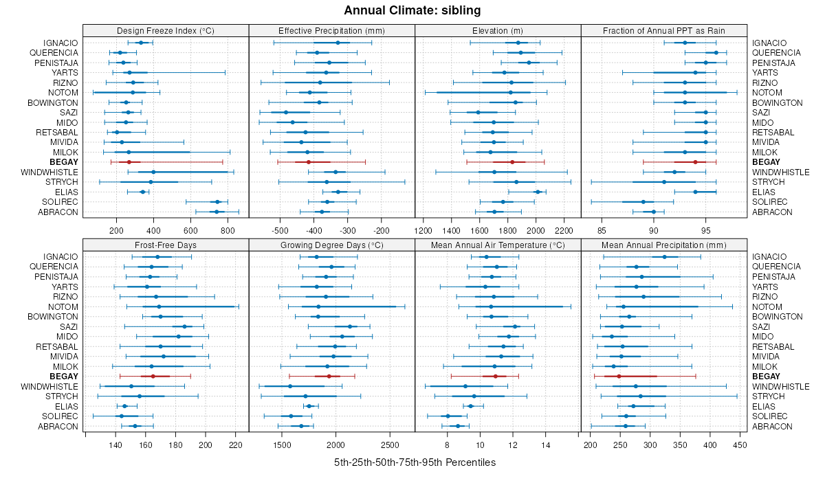
| Begay fine sandy loam, 3 to 12 percent slopes | 5 | 6163 | 52553 | 1rp8 | az625 | 1992 | 1:24000 |
Begay fine sandy loam, 1 to 3 percent slopes | 4 | 3501 | 52529 | 1rnh | az625 | 1992 | 1:24000 |
Chedeski-Begay complex, 1 to 14 percent slopes | 2338 | 8745 | 3441522 | 31kh5 | az695 | | 1:24000 |
Begay-Strych complex, 1 to 29 percent slopes | 2339 | 1070 | 3441448 | 315nd | az695 | | 1:24000 |
Begay-Mido-Milok complex, 1 to 5 percent slopes | 3 | 1925 | 814114 | 2rqqm | az707 | 2011 | 1:24000 |
Begay-Tsosie complex, 1 to 5 percent slopes | 6 | 18474 | 2025242 | 2sdwn | az711 | 2008 | 1:24000 |
Begay-Pensom, moderately deep complex, 1 to 10 percent slopes | 5 | 5571 | 1455136 | 2rqrz | az711 | 2008 | 1:24000 |
Pinavetes-Begay complex, white mesa, 1 to 5 percent slopes | 33 | 1813 | 1683766 | 2sdvw | az711 | 2008 | 1:24000 |
Begay family-Gullied land complex, 4 to 18 percent slopes | 6 | 786 | 2515658 | 20b1z | az712 | | 1:24000 |
Aquima-Rizno-Begay complex, 1 to 15 percent slopes | 3 | 103825 | 2450467 | 2sdxp | az713 | 2011 | 1:24000 |
Begay-Querencia-Rizno complex, 1 to 10 percent slopes | 11 | 42359 | 2427903 | 2sdxj | az713 | 2011 | 1:24000 |
Lithic Ustic Torriorthents-Begay complex, rocky 1 to 30 percent slopes | 27 | 36830 | 2515679 | 2sdz3 | az713 | 2011 | 1:24000 |
Begay-Mido complex, 1 to 15 percent slopes | 10 | 7989 | 2453941 | 2sdxt | az713 | 2011 | 1:24000 |
Begay-Gullied land complex, sodic, 1 to 3 percent slopes | 9 | 7242 | 2484134 | 2sdxz | az713 | 2011 | 1:24000 |
Begay loam, 1 to 5 percent slopes | 8 | 2418 | 2495425 | 2sdyw | az713 | 2011 | 1:24000 |
Arches-Begay-Mido complex, 1 to 25 percent slopes | 6 | 1876 | 2495410 | 2sdyg | az713 | 2011 | 1:24000 |
Sodic Ustic Haplocambids-Begay complex, 1 to 5 percent slopes | 48 | 795 | 2495426 | 2sdyx | az713 | 2011 | 1:24000 |
Penistaja-Begay complex, 1 to 8 percent slopes | 24 | 171370 | 54712 | 1txx | az714 | 1985 | 1:24000 |
Mido-Begay complex, 1 to 8 percent slopes | 18 | 39635 | 54701 | 1txk | az714 | 1985 | 1:24000 |
Pinavetes family-Begay complex, 10 to 60 percent slopes | 84 | 130561 | 58000 | 2qsxw | az715 | 2007 | 1:24000 |
Begay-Penistaja family complex, 2 to 8 percent slopes | 12 | 40027 | 58056 | 2qszg | az715 | 2007 | 1:24000 |
Begay-Milok family-Mathis family complex, 1 to 60 percent slopes | 11 | 38981 | 58055 | 2qszf | az715 | 2007 | 1:24000 |
Begay-Doakum family complex, 2 to 15 percent slopes | 10 | 16660 | 58054 | 2qszd | az715 | 2007 | 1:24000 |
Penistaja family-Begay complex, 1 to 8 percent slopes | 79 | 7527 | 1650661 | 2sfm4 | az715 | 2007 | 1:24000 |
Pinavetes family-Begay complex, 1 to 8 percent slopes | 83 | 5511 | 1650659 | 2sfm2 | az715 | 2007 | 1:24000 |
Begay fine sandy loam, 1 to 6 percent slopes | 18 | 5858 | 502009 | jvcv | co675 | 1986 | 1:24000 |
Begay fine sandy loam, 2 to 6 percent slopes | MC117 | 121 | 3170484 | k082 | co676 | 1983 | 1:24000 |
Begay fine sandy loam, 2 to 6 percent slopes | 117 | 1390 | 506697 | k082 | co680 | 1970 | 1:31680 |
Begay sandy loam, 6 to 12 percent slopes | 11 | 900 | 496750 | jnx6 | co683 | 1977 | 1:24000 |
Begay sandy loam, 1 to 6 percent slopes | 10 | 600 | 496749 | jnx5 | co683 | 1977 | 1:24000 |
Potts-Begay fine sandy loams, 2 to 7 percent slopes | 66 | 1794 | 497019 | jp5w | co685 | 1979 | 1:24000 |
Solirec-Abracon-Begay complex, 2 to 15 percent slopes | 122 | 142 | 929000 | 105pr | co685 | 1979 | 1:24000 |
Solirec-Abracon-Begay complex, 2 to 15 percent slopes | 267 | 1420 | 629971 | p4jn | co686 | 1992 | 1:31680 |
Begay-Mespun complex, 2 to 25 percent slopes | 7 | 283 | 506314 | jzvq | co692 | 1998 | 1:24000 |
Begay sandy loam, 2 to 15 percent slopes | 6 | 132 | 506301 | jzv9 | co692 | 1998 | 1:24000 |
Solirec-Abracon-Begay complex, 2 to 15 percent slopes | 213 | 46629 | 505488 | jz02 | ut047 | 1999 | 1:24000 |
Begay sandy loam, 2 to 15 percent slopes | 19 | 13158 | 505461 | jyz6 | ut047 | 1999 | 1:24000 |
Begay-Hideout-Rock outcrop complex, 2 to 15 percent slopes | 20 | 7867 | 505473 | jyzl | ut047 | 1999 | 1:24000 |
Begay-Sazi complex | 4 | 31667 | 504534 | jy09 | ut624 | 1985 | 1:24000 |
Begay-Rizno complex | 6 | 21658 | 504556 | jy10 | ut624 | 1985 | 1:24000 |
Begay-Sazi-Rizno complex | 5 | 14744 | 504545 | jy0n | ut624 | 1985 | 1:24000 |
Rizno-Begay complex | 51 | 9483 | 504547 | jy0q | ut624 | 1985 | 1:24000 |
Windwhistle-Begay complex | 78 | 4188 | 504576 | jy1n | ut624 | 1985 | 1:24000 |
Begay variant fine sandy loam, 3 to 15 percent slopes | 3 | 741 | 504523 | jxzy | ut624 | 1985 | 1:24000 |
Begay fine sandy loam, 2 to 8 percent slopes | BYB | 3674 | 504612 | 2qmb8 | ut629 | | 1:24000 |
Notom-Begay, moist-Bowington complex, 1 to 6 percent slopes | c60 | 1 | 2608486 | 2qdr6 | ut629 | | 1:24000 |
Begay fine sandy loam, 2 to 8 percent slopes | 5 | 23165 | 55178 | 1vdy | ut631 | 1982 | 1:24000 |
Begay loamy fine sand, 2 to 8 percent slopes | 4 | 21918 | 55167 | 1vdl | ut631 | 1982 | 1:24000 |
Milok-Begay complex | 50 | 12796 | 55179 | 1vdz | ut631 | 1982 | 1:24000 |
Begay-Mellenthin complex | 6 | 5068 | 55189 | 1vf9 | ut631 | 1982 | 1:24000 |
Begay-Rizno complex | 8 | 4949 | 55211 | 1vg0 | ut631 | 1982 | 1:24000 |
Begay-Mido complex | 7 | 4068 | 55200 | 1vfn | ut631 | 1982 | 1:24000 |
Begay-Rock outcrop-Mido complex, 2 to 35 percent slopes | 10 | 56518 | 55323 | 1vkm | ut633 | 1983 | 1:24000 |
Begay fine sandy loam, 2 to 6 percent slopes | 7 | 38319 | 55393 | 1vmw | ut633 | 1983 | 1:24000 |
Begay fine sandy loam, moist, 2 to 6 percent slopes | 8 | 30328 | 55404 | 1vn7 | ut633 | 1983 | 1:24000 |
Begay-Rizno complex, 3 to 15 percent slopes | 9 | 11315 | 55415 | 1vnl | ut633 | 1983 | 1:24000 |
Begay fine sandy loam, 2 to 6 percent slopes | MC117 | 2490 | 3202637 | k082 | ut633 | 1983 | 1:24000 |
Penistaja-Begay complex, 2 to 8 percent slopes | 64 | 13605 | 2427151 | 2mgn6 | ut642 | | 1:63360 |
Begay-Milok-Ildefonso complex, 2 to 8 percent slopes | 8 | 3517 | 2485498 | 2pfcc | ut642 | | 1:63360 |
Retsabal-Begay-Badland, gypsum association, 2 to 8 percent slopes | 77 | 2982 | 2427911 | 2mhfq | ut642 | | 1:63360 |
Begay loamy fine sand, 3 to 8 percent slopes | BbD | 9780 | 55270 | 1vhx | ut643 | 1976 | 1:63000 |
Begay family, 2 to 6 percent slopes | mt18 | 2919 | 3202669 | 2zbv4 | ut645 | | 1:24000 |
Begay family, dry, 2 to 6 percent slopes | mt8 | 862 | 3202664 | 2zbtz | ut645 | | 1:24000 |
Begay, saline-Querencia, saline-sodic complex, 1 to 9 percent slopes | 10 | 3209 | 2504476 | 2q3sh | ut685 | 1990 | 1:24000 |
Begay, saline-sodic-Begay, moist-Elias complex, 2 to 8 percent slopes | 11 | 2845 | 2556032 | 2qdrc | ut685 | 1990 | 1:24000 |
Begay-Ignacio-Retsabal complex, 2 to 60 percent slopes | 12 | 2178 | 2504483 | 2q3sq | ut685 | 1990 | 1:24000 |
Begay-Strych complex, 2 to 15 percent slopes | 14 | 574 | 2514991 | 2qdqf | ut685 | 1990 | 1:24000 |
Begay-Rizno complex, 1 to 20 percent slopes, moist | 13 | 427 | 2507449 | 2q70k | ut685 | 1990 | 1:24000 |
Chilton-Begay complex, 1 to 25 percent slopes | 18 | 344 | 2515011 | 2qghd | ut685 | 1990 | 1:24000 |
Begay sandy loam, 1 to 9 percent slopes | 8 | 270 | 2556035 | 2qdrg | ut685 | 1990 | 1:24000 |
Notom-Begay, moist-Bowington complex, 1 to 6 percent slopes | 60 | 246 | 2515016 | 2qdr6 | ut685 | 1990 | 1:24000 |
Begay fine sandy loam, 1 to 15 percent slopes, moist | 7 | 211 | 2507445 | 2q70f | ut685 | 1990 | 1:24000 |
Begay very fine sandy loam, 1 to 5 percent slopes, moist | 9 | 179 | 2608455 | 1ifsr | ut685 | 1990 | 1:24000 |
Progresso-Begay, dry complex, 1 to 8 percent slopes | 5130 | 6459 | 59857 | 208w | ut686 | 2004 | 1:24000 |
Begay fine sandy loam, 0 to 2 percent slopes, overwash | 116 | 1175 | 1897346 | 21pbq | ut687 | 2009 | 1:24000 |
Mido-Begay complex, 0 to 6 percent slopes | 104 | 9878 | 2383939 | 2l0p8 | ut688 | 2009 | 1:24000 |
Begay, bedrock substratum-Mido complex, 2 to 6 percent slopes | 92 | 3236 | 2247792 | 2fg0f | ut688 | 2009 | 1:24000 |
Begay-Ignacio complex, 2 to 10 percent slopes | 93 | 709 | 2247795 | 2fg0j | ut688 | 2009 | 1:24000 |
Begay-Gypimack-like-Cambria complex, 1 to 15 percent slopes | 2B07 | 3769 | 3358235 | 30zry | wy617 | | 1:24000 |
Begay-Threetop complex, 6 to 60 percent slopes | 5D14 | 487 | 3358233 | 30zrw | wy617 | | 1:24000 |
Zigweid-Shingle-Begay complex, 4 to 20 percent slopes | 5323 | 4712 | 2911970 | 2y4ys | wy629 | | 1:24000 |
Begay-Pultney complex, 6 to 20 percent slopes | 5322 | 933 | 2911969 | 2y4yr | wy629 | | 1:24000 |
Winnett-Begay association, 1 to 5 percent slopes | 2143 | 279 | 3136914 | 2ypql | wy629 | | 1:24000 |