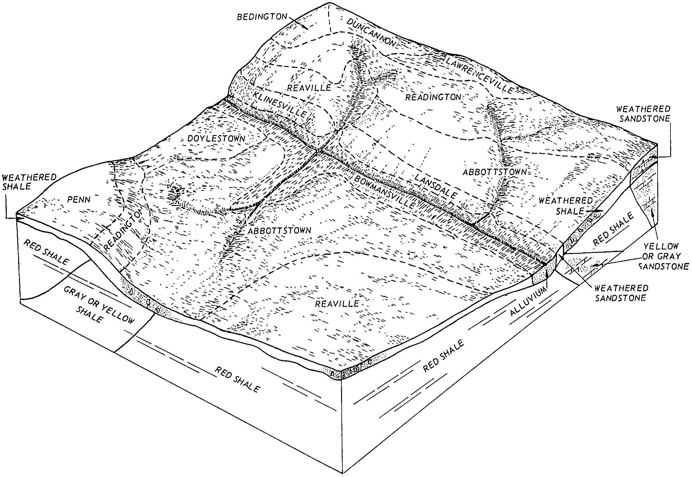
| Bedington channery silt loam, 2 to 6 percent slopes | BefB | 381 | 548575 | ldtz | nj019 | 1970 | 1:24000 |
Bedington channery silt loam, 6 to 12 percent slopes, eroded | BefC2 | 131 | 1478400 | 1lmdb | nj019 | 1970 | 1:24000 |
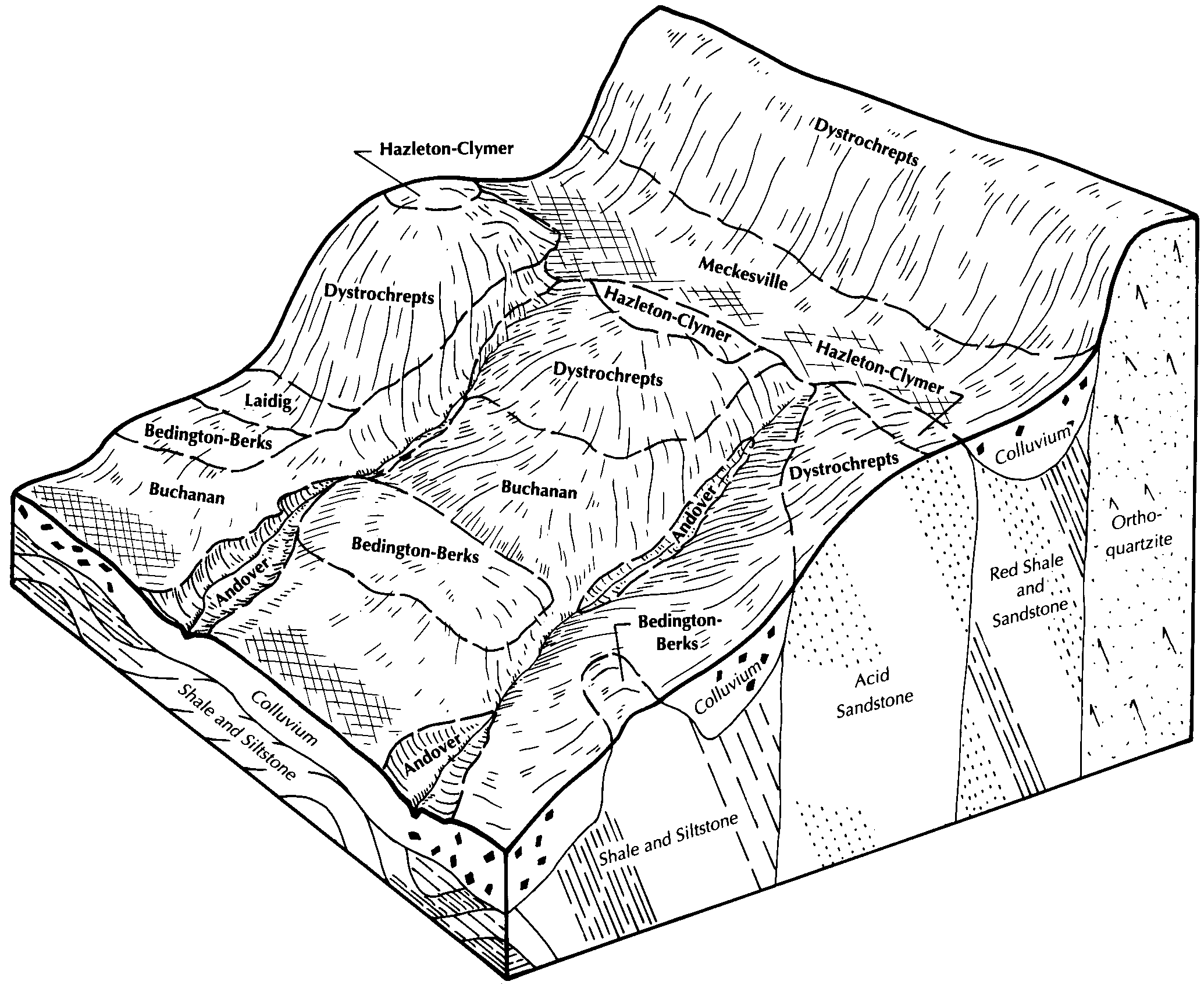
Bedington-Berks complex, 25 to 35 percent slopes, very stony | BdE | 11877 | 541764 | l5r8 | pa009 | 1989 | 1:24000 |
Bedington-Berks complex, 15 to 25 percent slopes, very stony | BdD | 6246 | 541763 | l5r7 | pa009 | 1989 | 1:24000 |
Bedington-Berks complex, 15 to 25 percent slopes | BcD | 4253 | 541761 | l5r5 | pa009 | 1989 | 1:24000 |
Bedington-Berks complex, 8 to 15 percent slopes, very stony | BdC | 3548 | 541762 | l5r6 | pa009 | 1989 | 1:24000 |
Bedington-Berks complex, 8 to 15 percent slopes | BcC | 3223 | 541760 | l5r4 | pa009 | 1989 | 1:24000 |
Bedington-Berks complex, 8 to 15 percent slopes | BfC | 6590 | 542974 | l709 | pa011 | 1997 | 1:24000 |
Bedington-Berks complex, 3 to 8 percent slopes | BfB | 6514 | 542973 | l708 | pa011 | 1997 | 1:24000 |
Berks-Bedington complex, 15 to 25 percent slopes | BhD | 3079 | 542975 | l70b | pa011 | 1997 | 1:24000 |
Bedington channery silt loam, 8 to 15 percent slopes | BeC | 1376 | 542320 | l6b6 | pa013 | 1978 | 1:20000 |
Bedington very stony silt loam, 8 to 25 percent slopes | BdD | 1234 | 542318 | l6b4 | pa013 | 1978 | 1:20000 |
Bedington channery silt loam, 3 to 8 percent slopes | BeB | 672 | 542319 | l6b5 | pa013 | 1978 | 1:20000 |
Bedington channery silt loam, 3 to 8 percent slopes | BeB | 1313 | 543600 | l7nh | pa017 | 1997 | 1:24000 |
Bedington channery silt loam, 0 to 3 percent slopes | BeA | 686 | 543599 | l7ng | pa017 | 1997 | 1:24000 |
Bedington channery silt loam, 8 to 15 percent slopes | BeC | 424 | 543601 | l7nj | pa017 | 1997 | 1:24000 |
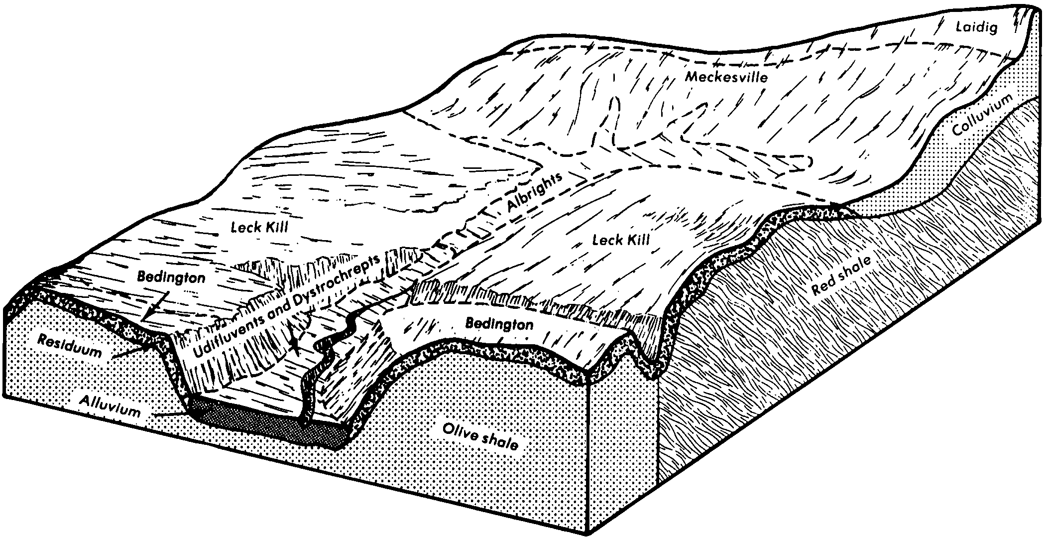
Bedington shaly silt loam, 3 to 8 percent slopes | BdB | 4632 | 693681 | r8tt | pa041 | 1980 | 1:15840 |
Bedington shaly silt loam, 8 to 15 percent slopes | BdC | 2667 | 693682 | r8tv | pa041 | 1980 | 1:15840 |
Bedington shaly silt loam, 15 to 25 percent slopes | BdD | 695 | 693683 | r8tw | pa041 | 1980 | 1:15840 |
Bedington shaly silt loam, 3 to 8 percent slopes, moderately eroded | BeB2 | 6388 | 540698 | l4mw | pa043 | 1967 | 1:15840 |
Bedington shaly silt loam, 8 to 15 percent slopes, moderately eroded | BeC2 | 2213 | 540699 | l4mx | pa043 | 1967 | 1:15840 |
Bedington shaly silt loam, 0 to 3 percent slopes | BeA | 322 | 540697 | l4mv | pa043 | 1967 | 1:15840 |
Bedington channery silt loam, 3 to 8 percent slopes | BegB | 94 | 737597 | srjg | pa043 | 1967 | 1:15840 |
Bedington channery silt loam, 15 to 25 percent slopes | BegD | 18 | 737599 | srjj | pa043 | 1967 | 1:15840 |
Bedington channery silt loam, 8 to 15 percent slopes | BegC | 10 | 737598 | srjh | pa043 | 1967 | 1:15840 |
Bedington channery silt loam, 3 to 8 percent slopes | BhB | 6711 | 545075 | l962 | pa055 | 1999 | 1:24000 |
Bedington channery silt loam, 8 to 15 percent slopes | BhC | 1912 | 545076 | l963 | pa055 | 1999 | 1:24000 |
Bedington channery silt loam, 15 to 25 percent slopes | BhD | 393 | 544820 | l8xv | pa057 | 1999 | 1:24000 |
Bedington channery silt loam, 8 to 15 percent slopes | BhC | 251 | 544819 | l8xt | pa057 | 1999 | 1:24000 |
Bedington channery silt loam, 3 to 8 percent slopes | BhB | 93 | 544818 | l8xs | pa057 | 1999 | 1:24000 |
Bedington channery silt loam, 8 to 15 percent slopes | BeC | 762 | 541959 | l5yk | pa061 | 1974 | 1:20000 |
Bedington channery silt loam, 15 to 25 percent slopes | BeD | 652 | 541960 | l5yl | pa061 | 1974 | 1:20000 |
Bedington channery silt loam, 3 to 8 percent slopes | BeB | 344 | 541958 | l5yj | pa061 | 1974 | 1:20000 |
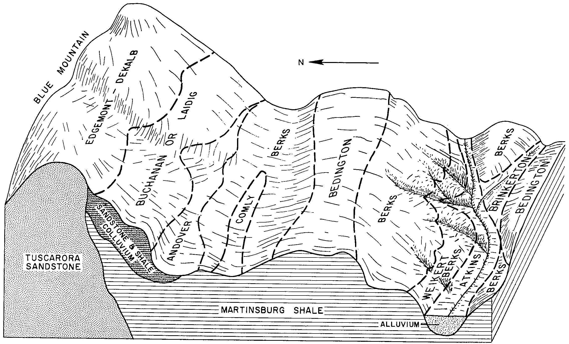
Bedington silt loam, 3 to 8 percent slopes | BdB | 18189 | 542719 | l6r2 | pa071 | 1982 | 1:15840 |
Bedington silt loam, 8 to 15 percent slopes | BdC | 12916 | 542720 | l6r3 | pa071 | 1982 | 1:15840 |
Bedington channery silt loam, 15 to 25 percent slopes | BeD | 9806 | 542721 | l6r4 | pa071 | 1982 | 1:15840 |
Bedington silt loam, 0 to 3 percent slopes | BdA | 1956 | 542718 | l6r1 | pa071 | 1982 | 1:15840 |
Bedington shaly silt loam, 3 to 8 percent slopes | BeB | 11849 | 541265 | l575 | pa075 | 1976 | 1:20000 |
Bedington shaly silt loam, 0 to 3 percent slopes | BeA | 1934 | 541264 | l574 | pa075 | 1976 | 1:20000 |
Bedington shaly silt loam, 8 to 15 percent slopes | BeC | 1146 | 541266 | l576 | pa075 | 1976 | 1:20000 |
Bedington channery silt loam, 8 to 15 percent slopes | BegC | 440 | 1397673 | 1hxd7 | pa075 | 1976 | 1:20000 |
Bedington channery silt loam, 3 to 8 percent slopes | BegB | 413 | 1397672 | 1hxd6 | pa075 | 1976 | 1:20000 |
Bedington shaly silt loam, 15 to 25 percent slopes | BeD | 340 | 541267 | l577 | pa075 | 1976 | 1:20000 |
Bedington channery silt loam, 15 to 25 percent slopes | BegD | 217 | 1397674 | 1hxd8 | pa075 | 1976 | 1:20000 |
Berks-Bedington complex, 15 to 25 percent slopes | 1BhD | 14 | 541356 | l5b3 | pa075 | 1976 | 1:20000 |
Bedington-Berks complex, 3 to 8 percent slopes | BfB | 6183 | 543108 | l74m | pa077 | 1997 | 1:24000 |
Bedington-Berks complex, 8 to 15 percent slopes | BfC | 2122 | 543109 | l74n | pa077 | 1997 | 1:24000 |
Bedington-Berks complex, 0 to 3 percent slopes | BfA | 957 | 543107 | l74l | pa077 | 1997 | 1:24000 |
Berks-Bedington complex, 15 to 25 percent slopes | BhD | 768 | 543110 | l74p | pa077 | 1997 | 1:24000 |
Bedington silt loam, 3 to 8 percent slopes | BeB | 752 | 538965 | l2tz | pa093 | 1980 | 1:20000 |
Bedington silt loam, 8 to 15 percent slopes | BeC | 500 | 538966 | l2v0 | pa093 | 1980 | 1:20000 |
Bedington silt loam, 15 to 25 percent slopes | BeD | 166 | 538967 | l2v1 | pa093 | 1980 | 1:20000 |
Bedington-Berks complex, 3 to 8 percent slopes | BfB | 2196 | 543236 | l78r | pa095 | 2007 | 1:12000 |
Bedington-Berks complex, 0 to 3 percent slopes | BfA | 614 | 543235 | l78q | pa095 | 2007 | 1:12000 |
Bedington-Berks complex, 8 to 15 percent slopes | BfC | 142 | 543237 | l78s | pa095 | 2007 | 1:12000 |
Bedington silt loam, 3 to 8 percent slopes | BeB | 2661 | 539600 | l3hg | pa097 | 1980 | 1:20000 |
Bedington silt loam, 8 to 15 percent slopes | BeC | 2263 | 539601 | l3hh | pa097 | 1980 | 1:20000 |
Bedington silt loam, 15 to 25 percent slopes | BeD | 461 | 539602 | l3hj | pa097 | 1980 | 1:20000 |
Bedington shaly silt loam, 8 to 15 percent slopes | BdC | 205 | 693907 | r923 | pa099 | 1980 | 1:15840 |
Bedington shaly silt loam, 3 to 8 percent slopes | BdB | 182 | 693906 | r922 | pa099 | 1980 | 1:15840 |
Bedington shaly silt loam, 15 to 25 percent slopes | BdD | 11 | 693908 | r924 | pa099 | 1980 | 1:15840 |
Bedington silt loam, 3 to 8 percent slopes | BeB | 1364 | 540790 | l4qv | pa109 | 1980 | 1:20000 |
Bedington silt loam, 3 to 8 percent slopes | BeB | 528 | 540885 | l4tx | pa119 | 1980 | 1:20000 |
Bedington silt loam, 8 to 15 percent slopes | BeC | 192 | 540886 | l4ty | pa119 | 1980 | 1:20000 |