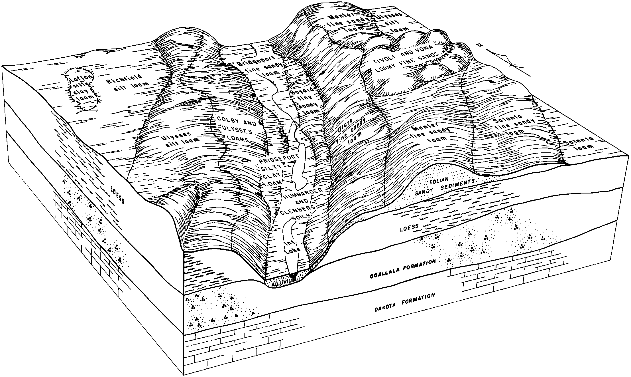
| Bayard fine sandy loam, 2 to 6 percent slopes | 10 | 86 | 96798 | 37qj | co063 | 1996 | 1:24000 |
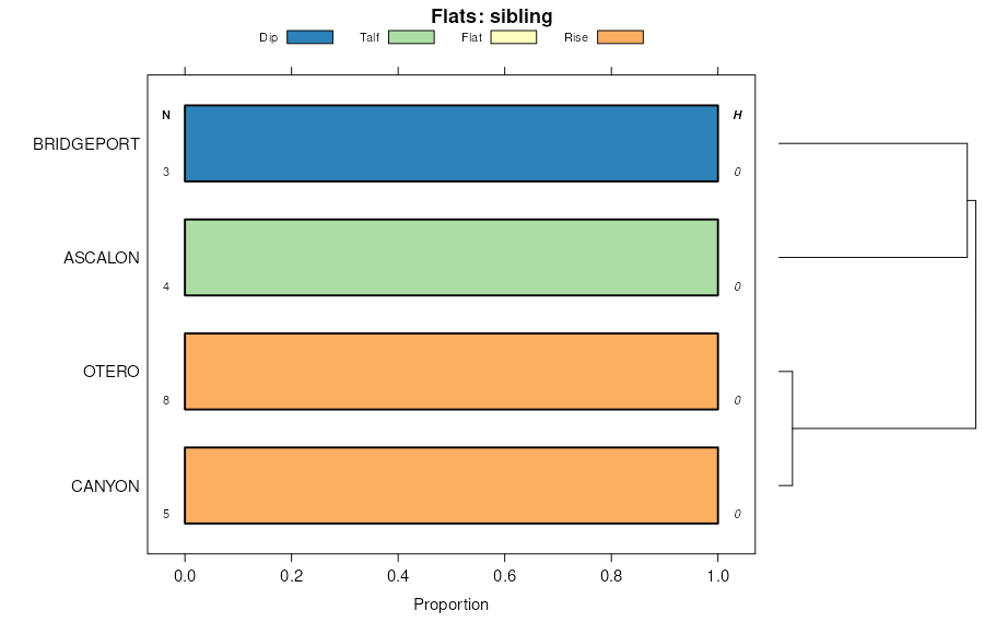
Bayard-Canyon complex, 1 to 9 percent slopes | 15 | 3246 | 94494 | 35b6 | co075 | 1974 | 1:24000 |
Bayard-Canyon complex, 3 to 5 percent slopes | BcC | 515 | 94770 | 35m3 | co095 | 1971 | 1:20000 |
Bayard-Ascalon-Manter sandy loams, 5 to 12 percent slopes | BaE | 9172 | 94919 | 35rx | co115 | 1969 | 1:15840 |
Bayard-Canyon complex, 5 to 12 percent slopes | BcE | 7114 | 94920 | 35ry | co115 | 1969 | 1:15840 |
Bayard fine sandy loam, 2 to 6 percent slopes | 7 | 11753 | 95095 | 35yl | co125 | 1976 | 1:24000 |
Las-Bayard sandy loams, occasionally flooded | 1234 | 2161 | 1152315 | 17p2g | ks055 | 1962 | 1:24000 |
Bayard fine sandy loam, 0 to 3 percent slopes | 1327 | 868 | 1152299 | 2w5f1 | ks055 | 1962 | 1:24000 |
Bayard fine sandy loam, 0 to 3 percent slopes | 1327 | 3345 | 1380648 | 2w5f1 | ks067 | 1965 | 1:24000 |
Bayard fine sandy loam, 0 to 1 percent slopes | 1326 | 1493 | 1152207 | 2w5dy | ks075 | 1959 | 1:24000 |
Bayard fine sandy loam, 0 to 3 percent slopes | 1327 | 88 | 1380614 | 2w5f1 | ks081 | 1965 | 1:24000 |
Bayard fine sandy loam, 0 to 1 percent slopes | 1326 | 986 | 1152252 | 2w5dy | ks093 | 1961 | 1:24000 |
Bayard fine sandy loam, 0 to 3 percent slopes | 1327 | 1644 | 1382621 | 2w5f1 | ks175 | 1963 | 1:24000 |
Bayard very fine sandy loam, 1 to 3 percent slopes | 1307 | 15383 | 1692458 | 2wz97 | ne007 | 1988 | 1:20000 |
Bayard very fine sandy loam, 3 to 6 percent slopes | 1308 | 12735 | 1692459 | 1tt4g | ne007 | 1988 | 1:20000 |
Bayard-Dix complex, 9 to 20 percent slopes | 1316 | 10805 | 1692463 | 1tt4l | ne007 | 1988 | 1:20000 |
Bayard-Dix complex, 3 to 9 percent slopes | 1315 | 7763 | 1692462 | 1tt4k | ne007 | 1988 | 1:20000 |
Bayard very fine sandy loam, 6 to 9 percent slopes | 1309 | 4135 | 1692460 | 1tt4h | ne007 | 1988 | 1:20000 |
Bayard very fine sandy loam, 9 to 20 percent slopes | 1310 | 2855 | 1692461 | 1tt4j | ne007 | 1988 | 1:20000 |
Bayard fine sandy loam, 0 to 3 percent slopes | 1327 | 119 | 2228138 | 2w5dz | ne007 | 1988 | 1:20000 |
Bayard fine sandy loam, 3 to 6 percent slopes | 1301 | 42 | 2228137 | 2dskd | ne007 | 1988 | 1:20000 |
Canyon-Bayard complex, 6 to 20 percent slopes | 5155 | 31033 | 1698672 | 1v0lw | ne033 | 1989 | 1:20000 |
Bayard fine sandy loam, 0 to 3 percent slopes | 1327 | 13145 | 2219675 | 2w5dz | ne033 | 1989 | 1:20000 |
Bayard fine sandy loam, 3 to 6 percent slopes | 1301 | 10944 | 1698660 | 1v0lh | ne033 | 1989 | 1:20000 |
Bayard fine sandy loam, 0 to 1 percent slopes | 1326 | 4961 | 1698658 | 2w5dy | ne033 | 1989 | 1:20000 |
Bayard fine sandy loam, 6 to 9 percent slopes | 1302 | 4411 | 1698661 | 1v0lj | ne033 | 1989 | 1:20000 |
Bayard fine sandy loam, 9 to 20 percent slopes | 1303 | 1121 | 1698662 | 1v0lk | ne033 | 1989 | 1:20000 |
Chappell-Bayard-Broadwater complex, 0 to 2 percent slopes | 1372 | 81 | 2219677 | 2dhrh | ne033 | 1989 | 1:20000 |
Vetal and Bayard soils, 1 to 6 percent slopes | 5070 | 12294 | 358176 | d0q2 | ne045 | 1973 | 1:20000 |
Bayard fine sandy loam, 0 to 3 percent slopes | 1327 | 4794 | 1698725 | 2w5dz | ne069 | 1995 | 1:20000 |
Bayard fine sandy loam, 0 to 1 percent slopes | 1326 | 2641 | 1698724 | 2w5dy | ne069 | 1995 | 1:20000 |
Bayard loam, 0 to 1 percent slopes | 1305 | 1585 | 1698728 | 1v0np | ne069 | 1995 | 1:20000 |
Bayard fine sandy loam, 3 to 6 percent slopes | 1301 | 1488 | 1698726 | 1v0nm | ne069 | 1995 | 1:20000 |
Bayard very fine sandy loam, 1 to 3 percent slopes | 1307 | 261 | 1698727 | 2wz96 | ne069 | 1995 | 1:20000 |
Bayard fine sandy loam, 0 to 3 percent slopes | 1327 | 1060 | 1699287 | 2w5dz | ne087 | 1965 | 1:20000 |
Bayard fine sandy loam, 0 to 1 percent slopes | 1326 | 628 | 1699286 | 2w5dy | ne087 | 1965 | 1:20000 |
Bayard loam, 0 to 1 percent slopes | 1305 | 405 | 1699293 | 1v17x | ne087 | 1965 | 1:20000 |
Bayard very fine sandy loam, 1 to 3 percent slopes | 1307 | 21218 | 1698874 | 2wz96 | ne101 | 1990 | 1:20000 |
Bayard fine sandy loam, 0 to 3 percent slopes | 1327 | 14 | 2219589 | 2w5dz | ne101 | 1990 | 1:20000 |
Bayard fine sandy loam, 0 to 3 percent slopes | 1327 | 21596 | 1692536 | 2w5dz | ne105 | 2004 | 1:24000 |
Chappell-Bayard-Broadwater complex, 0 to 2 percent slopes | 1372 | 10949 | 1692540 | 1tt72 | ne105 | 2004 | 1:24000 |
Bayard fine sandy loam, 3 to 6 percent slopes | 1301 | 4583 | 1692537 | 1tt6z | ne105 | 2004 | 1:24000 |
Bayard very fine sandy loam, 1 to 3 percent slopes | 1307 | 21 | 2227923 | 2wz97 | ne105 | 2004 | 1:24000 |
Bayard fine sandy loam, 0 to 1 percent slopes | 1326 | 6 | 2227930 | 2w5dy | ne105 | 2004 | 1:24000 |
Bayard very fine sandy loam, 1 to 3 percent slopes | 1307 | 1179 | 2219722 | 2wz96 | ne111 | 1971 | 1:24000 |
Bayard fine sandy loam, 0 to 3 percent slopes | 1327 | 201 | 2220355 | 2w5dz | ne123 | 1981 | 1:20000 |
Bayard-Dix complex, 9 to 20 percent slopes | 1316 | 86 | 2220378 | 2djh3 | ne123 | 1981 | 1:20000 |
Bayard very fine sandy loam, 6 to 9 percent slopes | 1309 | 19 | 2220377 | 2djh2 | ne123 | 1981 | 1:20000 |
Otero-Bayard fine sandy loams, 0 to 3 percent slopes | 1712 | 16749 | 1653773 | 1shwj | ne157 | 1965 | 1:20000 |
Bayard fine sandy loam, 3 to 6 percent slopes | 1301 | 6347 | 1653719 | 1shts | ne157 | 1965 | 1:20000 |
Bayard fine sandy loam, 6 to 9 percent slopes | 1302 | 4977 | 1653720 | 1shtt | ne157 | 1965 | 1:20000 |
Otero-Bayard fine sandy loams, 3 to 6 percent slopes | 1713 | 4369 | 1653774 | 1shwk | ne157 | 1965 | 1:20000 |
Dix-Bayard complex, 6 to 20 percent slopes | 1575 | 3428 | 1653733 | 1shv7 | ne157 | 1965 | 1:20000 |
Bayard fine sandy loam, 9 to 20 percent slopes | 1303 | 3085 | 1653721 | 1shtv | ne157 | 1965 | 1:20000 |
Otero-Bayard fine sandy loams, 6 to 9 percent slopes | 1714 | 2535 | 1653775 | 1shwl | ne157 | 1965 | 1:20000 |
Bayard very fine sandy loam, 6 to 9 percent slopes | 1309 | 1585 | 2227638 | 2ds19 | ne157 | 1965 | 1:20000 |
Bayard very fine sandy loam, 3 to 6 percent slopes | 1308 | 1239 | 2227637 | 2ds18 | ne157 | 1965 | 1:20000 |
Bayard fine sandy loam, 0 to 3 percent slopes | 1327 | 775 | 1653718 | 2w5dz | ne157 | 1965 | 1:20000 |
Blueridge-Bayard complex, 6 to 20 percent slopes | 5928 | 446 | 2227674 | 2ds2g | ne157 | 1965 | 1:20000 |
Bayard very fine sandy loam, 1 to 3 percent slopes | 1307 | 343 | 2227636 | 2wz97 | ne157 | 1965 | 1:20000 |
Bayard very fine sandy loam, 9 to 20 percent slopes | 1310 | 82 | 2227639 | 2ds1b | ne157 | 1965 | 1:20000 |
Bayard-Dix complex, 3 to 9 percent slopes | 1315 | 10 | 2227640 | 2ds1c | ne157 | 1965 | 1:20000 |
Blueridge-Bayard complex, 6 to 20 percent slopes | 5928 | 12421 | 357877 | d0df | ne165 | 1993 | 1:20000 |
Bayard fine sandy loam, 0 to 3 percent slopes | 1327 | 5492 | 357861 | 2w5dz | ne165 | 1993 | 1:20000 |
Bayard fine sandy loam, 3 to 6 percent slopes | 1301 | 4094 | 357862 | d0cy | ne165 | 1993 | 1:20000 |
Bayard fine sandy loam, 0 to 1 percent slopes | 1326 | 137 | 357860 | 2w5dy | ne165 | 1993 | 1:20000 |
Bayard fine sandy loam, 0 to 3 percent slopes | 108 | 1758 | 349529 | 2w5dz | wy027 | 1993 | 1:24000 |
Alice-Bayard fine sandy loams, 0 to 6 percent slopes | 103 | 22029 | 104445 | 3hp6 | wy031 | 1998 | 1:24000 |
Graystone-Greenhope-Bayard fine sandy loams, 0 to 10 percent slopes | 164 | 14699 | 104519 | 3hrl | wy031 | 1998 | 1:24000 |
Bayard-Phiferson-Treon, thin solum complex, 3 to 45 percent slopes | 109 | 13319 | 104458 | 3hpm | wy031 | 1998 | 1:24000 |
Bayard-Phiferson-Treon, thin solum complex, 0 to 6 percent slopes | 108 | 8839 | 104456 | 3hpk | wy031 | 1998 | 1:24000 |
Cedak-Bayard-Treon, thin solum, complex, 0 to 6 percent slopes | 124 | 2072 | 104481 | 3hqc | wy031 | 1998 | 1:24000 |
Bayard fine sandy loam, 0 to 3 percent slopes | 106 | 1583 | 104453 | 2w5dz | wy031 | 1998 | 1:24000 |
Featherlegs-Bayard fine sandy loams, 0 to 6 percent slopes | 150 | 1410 | 104505 | 3hr4 | wy031 | 1998 | 1:24000 |
Bayard fine sandy loam, 0 to 15 percent slopes | 107 | 41 | 104423 | 3hnh | wy031 | 1998 | 1:24000 |
Bayard fine sandy loam, 0 to 7 percent slopes | BgB | 5619 | 104667 | 3hxc | wy615 | 1965 | 1:20000 |
Bayard and Otero fine sandy loams, 0 to 3 percent slopes | BoA | 3048 | 104668 | 3hxd | wy615 | 1965 | 1:20000 |
Bayard and Otero fine sandy loams, 3 to 6 percent slopes | BoB | 679 | 104669 | 3hxf | wy615 | 1965 | 1:20000 |
Bayard fine sandy loam, 0 to 3 percent slopes | 11 | 18034 | 104799 | 2w5dz | wy621 | 1980 | 1:24000 |
Bayard fine sandy loam, 3 to 6 percent slopes | 12 | 8026 | 104800 | 3j1n | wy621 | 1980 | 1:24000 |
Bayard variant fine sandy loam, 0 to 3 percent slopes | 14 | 3879 | 104802 | 3j1q | wy621 | 1980 | 1:24000 |
Bayard fine sandy loam, 6 to 10 percent slopes | 13 | 2280 | 104801 | 3j1p | wy621 | 1980 | 1:24000 |
Bayard fine sandy loam, wet, 0 to 3 percent slopes | 55 | 82 | 104765 | 3j0j | wy621 | 1980 | 1:24000 |
Bayard fine sandy loam, 0 to 15 percent slopes | 59 | 63 | 104770 | 3j0p | wy621 | 1980 | 1:24000 |
Featherlegs-Bayard fine sandy loams, 0 to 6 percent slopes | 43 | 49 | 1414813 | 1jh74 | wy715 | 1974 | 1:20000 |
Blueridge-Bayard complex, 6 to 20 percent slopes | 95 | 25 | 1415381 | 1jhtg | wy715 | 1974 | 1:20000 |
Bayard-Paoli fine sandy loams, 0 to 10 percent slopes | 107 | 7064 | 104908 | 3j54 | wy721 | 1994 | 1:24000 |
Bayard fine sandy loam, 0 to 15 percent slopes | 105 | 3266 | 104906 | 3j52 | wy721 | 1994 | 1:24000 |
Treon, dry-Bayard association, 3 to 30 percent slopes | 175 | 1859 | 104976 | 3j7b | wy721 | 1994 | 1:24000 |
Bayard fine sandy loam, wet, 0 to 3 percent slopes | 106 | 783 | 104907 | 3j53 | wy721 | 1994 | 1:24000 |
Urban land-Bayard complex, 0 to 15 percent slopes | 185 | 113 | 104986 | 3j7n | wy721 | 1994 | 1:24000 |


